Download the high-resolution Sullivan County JPG maps in one ZIP from the file box below. Inside the ZIP are four 2572×3638 JPG originals covering the county, city, terrain-and-water, and elevation views. The maps show a county divided between the Wabash River lowlands along the western boundary, the US 41 town corridor through Sullivan, and higher creek-cut hills toward Hymera, Dugger, and the northeast. They also identify Sugar Creek, Turman Creek, the Busseron Creek system, Lake Sullivan, and several smaller ponds and lakes.
This Sullivan County Indiana Map set is easiest to understand from Sullivan itself. US 41 runs north through Shelburn and Farmersburg and south toward Carlisle, while Route 54 heads east toward Dugger and Route 154 reaches toward the river side. Merom and Graysville lie much closer to the Wabash River, giving the western edge a very different road and terrain pattern from the central corridor.
The elevation map makes that contrast unmistakable. The legend reports an actual range of about 80 to 215 meters and a mean of 155 meters. Broad dark-green low ground follows the Wabash River side and expands through the southwest, while tan and brown hills become much more extensive in the east and northeast. Creek valleys cut lower paths through those hills, so the upland side is broken rather than flat.
Table of Contents
Wabash River shapes both the western boundary and the broad lowland beside it
The western side of Sullivan County is defined by Wabash River more strongly than by any road. The river bends repeatedly along the boundary, with Graysville and Merom lying close to the river side. On the general map, the contrast between this irregular natural edge and the straighter interior road grid is easy to see.
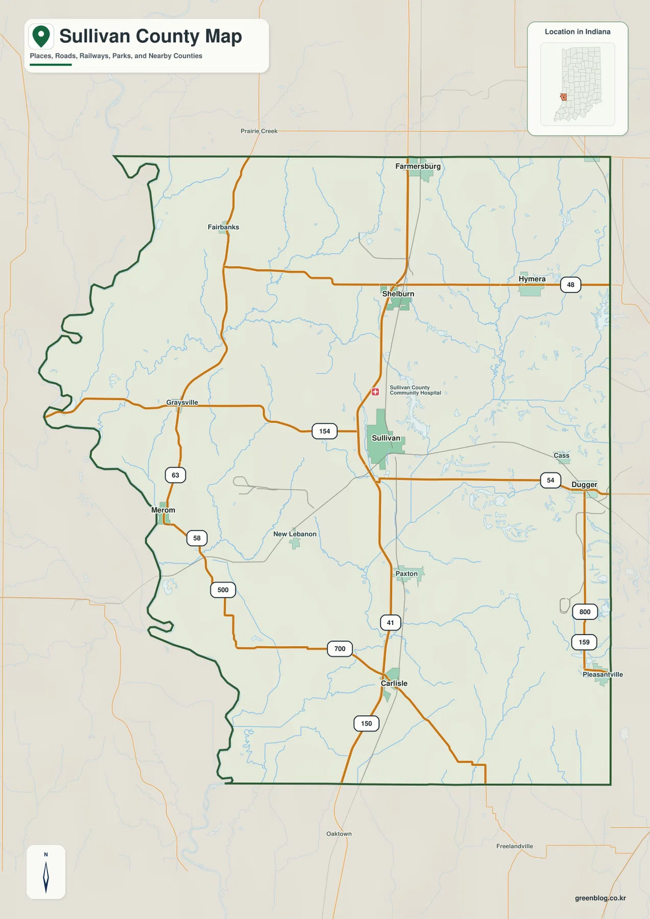
Several interior waterways head toward the river side. Turman Creek and Sugar Creek cross the western and central interior, while Tilley Creek is labeled farther south. These channels help explain why the elevation map shows such broad low ground between the river and the central part of the county.
Routes 63 and 58 provide useful road references near Merom, while New Lebanon lies farther inland between the river edge and Sullivan. The western side therefore combines river bends, tributary valleys, and small communities that are not arranged along the same straight corridor as the US 41 towns.
The general map is appropriate for county-scale orientation, major routes, communities, and boundary shape. It is not a live traffic product, so current construction, closures, and travel restrictions should be checked with a current transportation source.
US 41 creates a long settlement corridor through the middle of the county
US 41 provides the simplest road framework inside the county. It enters near Farmersburg, continues through Shelburn and Sullivan, and runs south past Paxton toward Carlisle. From Sullivan, Route 154 extends west and Route 54 heads east toward Dugger, making the county seat a useful point for comparing the river side with the eastern hill country.
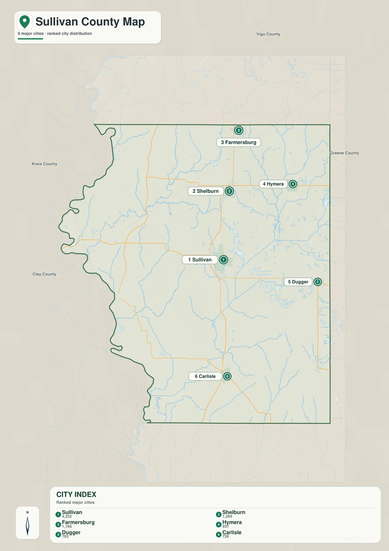
The city map removes most road detail and highlights Sullivan, Shelburn, Farmersburg, Hymera, Dugger, and Carlisle. It makes the elongated north–south distribution obvious, while Hymera and Dugger stand apart on the eastern side. Carlisle is separated farther south, showing how much the county extends beyond Sullivan.
The CITY INDEX also prints numeric values beside the six place names. Because the city graphic does not state a year or a separate source for its numbers, this article treats them only as labels on the supplied map rather than as current population counts. For current population figures, use a recent U.S. Census release instead of the unlabeled values printed in the city graphic.
Neighboring labels place Vigo County to the north, Greene County to the east, Knox County to the south and southwest, and Clay County around the northern-eastern side of the broader view. Those surrounding references help explain why Farmersburg lies near the north while Hymera and Dugger approach the eastern boundary.
Sugar Creek and the Busseron Creek system split the interior into several drainage areas
The terrain-and-water map shows that the interior is divided by several named creeks rather than one single river. Sugar Creek crosses the central part of the county toward the Wabash side, while West Fork Busseron Creek and Sulphur Creek run through the east and northeast. Farther south, Busseron Creek bends through lower terrain between the central corridor and the eastern hills.
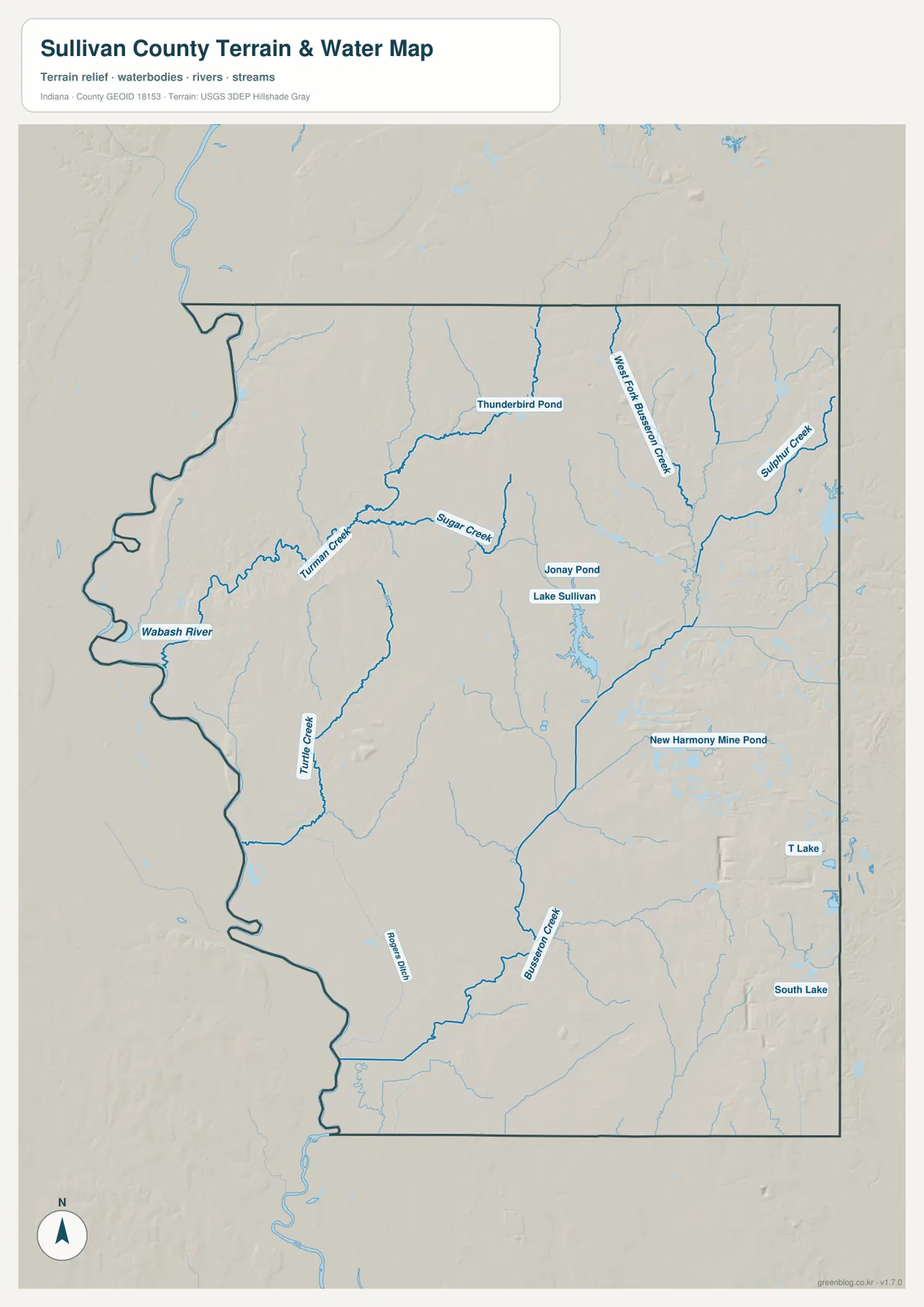
Lake Sullivan is one of the easiest central-eastern water references, while Thunderbird Pond is labeled farther north. New Harmony Mine Pond appears in the southeast, with South Lake farther east. These waters are shown separately rather than as one connected lake system and should be treated as distinct mapped features.
The creek network also helps explain the relief map. Where the eastern hills are brown and tan, the creek valleys remain green or light green as they cut through the higher surface. That relationship is especially noticeable around Sulphur Creek and the Busseron Creek system.
Use the water view to locate Sullivan County rivers, creeks, lakes, and ponds at county scale; it is not intended to define flood zones, parcels, legal water boundaries, water depth, drainage design, or navigation conditions. It is useful for locating rivers, creeks, lakes, and ponds and comparing them with nearby roads and communities. For a property-specific drainage question or a current flood situation, consult the agency data created for that purpose.
The 80–215 meter surface rises sharply from the Wabash lowlands toward the east
The elevation legend reports an actual Sullivan County range of about 80 to 215 meters and a mean of 155 meters. On this Sullivan County color scale, green marks the lower ground, with yellow and tan giving way to brown as elevation increases. The widest low ground follows Wabash River and spreads across the southwest, while the east and northeast contain much more extensive brown high ground.
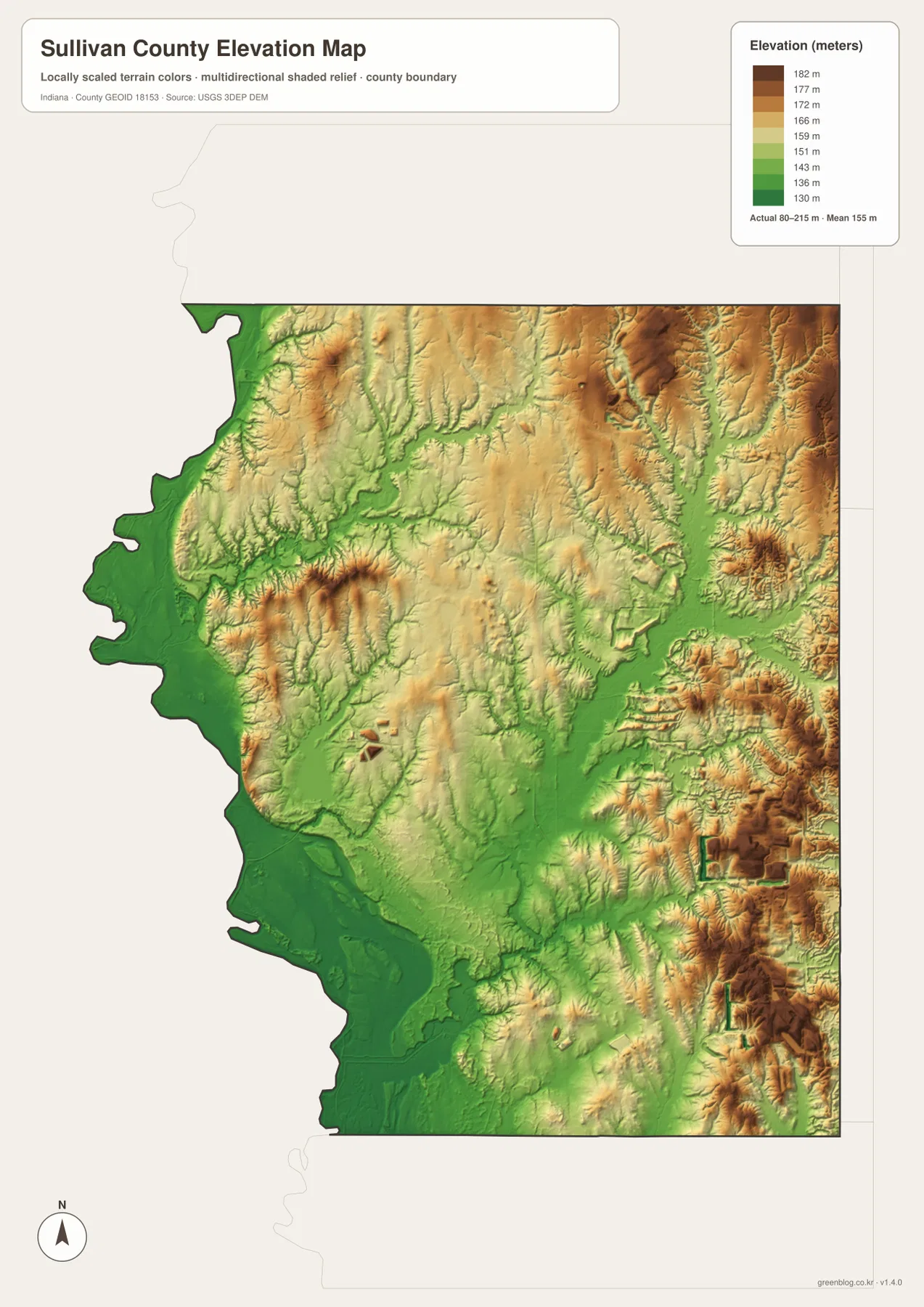
The eastern uplands are not a flat plateau. Green and light-green valleys cut deeply into the tan and brown terrain, especially around Sulphur Creek and the Busseron Creek system. Closely spaced ridges are most obvious in the northeast, where the terrain differs sharply from the broad Wabash River lowland.
Sullivan sits within a transition zone between those extremes. Moving west from the city brings the broad lowland closer, while the Lake Sullivan and eastern areas rise into more broken hills. Isolated high ground also appears farther west, so the county is better described as a river lowland mixed with ridges and creek valleys than as one smooth slope.
The relief image is meant to compare broad height differences across Sullivan County, not to provide surveyed elevations at individual sites. Do not use it to assign an exact height to a building, field, road point, parcel corner, or construction location. If a project depends on precise site elevation, check the underlying elevation data or a professional survey rather than this county overview.
Keep Sullivan fixed while moving from roads to water and relief
For ordinary orientation, begin with the general county map and locate Sullivan, US 41, Route 54, and the Wabash River edge. The city map is cleaner when the goal is simply to compare Farmersburg, Shelburn, Hymera, Dugger, and Carlisle around the county seat. Returning to the road view after that makes the outer communities easier to place.
For water features, use the terrain-and-water map to locate Wabash River, Sugar Creek, West Fork Busseron Creek, and Lake Sullivan. Then find the same areas on the elevation map. The river side remains broadly low, while the eastern hills are cut by narrow creek valleys.
The page uses smaller WebP previews so the Sullivan County maps load quickly in a browser. The ZIP keeps the full-resolution JPG originals for the county, city, terrain-and-water, and elevation views instead of the smaller WebP previews shown on the page. All four originals are portrait-oriented at 2572 by 3638 pixels, leaving more detail available for A3 output and close inspection of road or creek labels.
A practical comparison routine is to keep Sullivan fixed as the reference point. Find US 41 and Route 54 on the general map, compare the surrounding towns on the city view, then trace Wabash River and Sugar Creek on the water map. Finish with the elevation image and compare the low western greens with the higher eastern browns.
Frequently Asked Questions
What is the easiest place to use as a starting point on the Sullivan County maps?
Sullivan is the most useful starting point because US 41 passes through the area, Route 54 heads east toward Dugger, and the Wabash River lowlands lie to the west. Keeping Sullivan fixed makes it easy to compare the central town corridor with the river edge and eastern hills.
Are Wabash River and the Busseron Creek system part of the same water feature?
No. Wabash River is the large river along the western boundary, while Busseron Creek and West Fork Busseron Creek are separate interior streams. Sugar Creek and Sulphur Creek also occupy different valleys within the county.
Where does the elevation map show the strongest terrain contrast?
The clearest contrast is between the broad low green terrain along Wabash River and across the southwest and the higher tan-brown hills in the east and northeast. The legend reports an actual range of about 80–215 meters and a mean of 155 meters.
Map File Information
Download the high-resolution JPG originals for the Sullivan County general map, city map, terrain-and-water map, and elevation map in one ZIP. Choose those JPG originals when you need to zoom in on Sullivan County labels or prepare an A3 print.
- Printable Size: 2572×3638 px each
Related Maps
Sources and References
The road, settlement, water, and elevation descriptions above are based on the supplied Sullivan County maps and asset information. The links below point to official boundary, hydrography, and elevation sources that can be consulted when more detailed source data are needed.
- U.S. Census Bureau TIGER/Line Shapefiles – official county boundary, road, and place reference data
- USGS National Hydrography – official river, creek, lake, and pond data information
- USGS 3D Elevation Program – elevation source data and program information
Green Map creates custom-edited map images using open geographic data sources such as geoBoundaries, Natural Earth, OpenStreetMap, and government open data.
These maps are edited visual materials, not raw data files, and are provided for education, documents, presentations, and graphic reference.