Randolph County lies on Indiana’s eastern side, where Winchester provides a useful center for a county whose towns, rivers, and relief pull in several directions. Route 32 runs east from Winchester toward Union City near the state line, Farmland and Parker City sit to the west, Ridgeville is well to the north, and Lynn anchors the south. The water pattern is just as varied: the supplied map labels the Mississinawa River across the north, White River through the middle, Little Mississinawa River along the east, and separate Little White and Whitewater river corridors in the southwest. This Randolph County Indiana Map page includes all four views for on-screen reference, and you can download the original 3638×2572 high-resolution JPG maps together in one ZIP from the file box below.
The county becomes easier to understand when the roads and landform are read together. Route 32 supplies a strong central east–west line between Winchester and Union City, while Route 36 forms another east–west reference farther south near Modoc and Lynn. Route 28 crosses the northern half on a different alignment, and Route 27 descends from the Winchester area toward the southern part of the county. Against that relatively straight road framework, the rivers and creek valleys curve across the landscape. The elevation surface adds a broad north–south contrast, with greener lower ground across much of the north and extensive orange-brown uplands in the south and southeast.
Each supplied image answers a different geographic question without requiring the reader to learn specialized GIS terminology. The general county map is best for towns, numbered roads, and the boundary. The city view removes much of the secondary detail and emphasizes six named places. The terrain-and-water map is the clearest source for river and creek names, while the elevation view shows an actual county range of about 255 to 378 meters with a mean of 331 meters. Reading those views around the same familiar places—especially Winchester, Union City, Ridgeville, and Lynn—makes the differences between northern lowlands and southern high ground much easier to see.
Table of Contents
Three road levels organize the county from Ridgeville to Lynn
Winchester is the most practical place to start on the general county map. It sits slightly east of the county’s center, with Route 32 running directly through the area toward Union City. Route 27 turns south from the Winchester vicinity, creating a second strong directional line. Once those roads are located, the other labeled places become easier to place: Farmland and Parker City lie west of Winchester, Ridgeville is north, and Lynn is south. The county no longer looks like an undifferentiated grid of roads and blue stream lines.
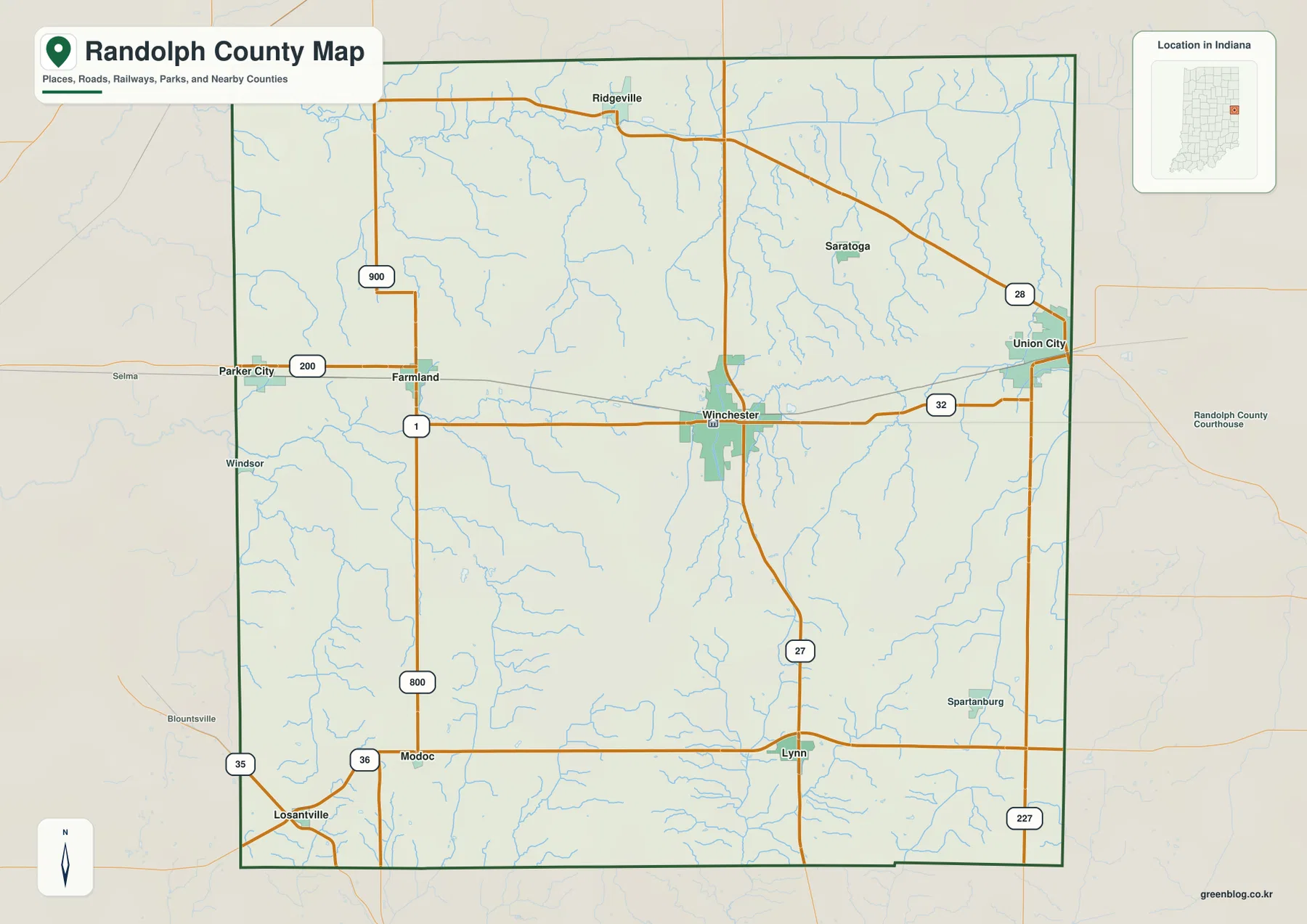
The northern road pattern is separated from the center by Route 28, which passes below Ridgeville and angles toward the Union City side of the county. Farther south, Route 36 crosses near Modoc and Lynn. Those three east–west bands—Route 28 in the north, Route 32 through the middle, and Route 36 in the south—make a useful mental framework. They are not perfectly parallel, but they divide the county into broad strips that can be matched with different towns and different terrain.
West of Winchester, Farmland sits near Route 1, which forms a clear north–south line. Parker City is farther toward the western boundary near the road marked 200, and the map also shows 900 north of Farmland and 800 farther south. These smaller route labels matter mainly because they show how the western side differs from Winchester’s road arrangement. Instead of one obvious central junction, the western towns sit among several long, straight segments that lead toward the county edge.
The southern tier has its own references. Modoc is near Route 36 in the southwest, Lynn is farther east on the same broad east–west band, and Route 27 approaches Lynn before continuing toward Winchester. A 227 marker appears near the southeastern boundary. The map also contains many small blue waterways around these roads, especially east of the center and through the southern half. For exact stream names, however, the specialized water map is much easier to use than the general road view.
The six highlighted places form a simple compass around Winchester
The city map reduces the county to six prominently labeled places: Winchester, Union City, Farmland, Parker City, Lynn, and Ridgeville. Their arrangement is more useful than the ranking itself. Winchester occupies the central reference position. Union City is near the eastern edge, Farmland and Parker City form a western pair, Ridgeville is clearly north, and Lynn stands apart to the south. Taken together, the six labels form a rough compass that can be carried into the more detailed road, water, and elevation views.
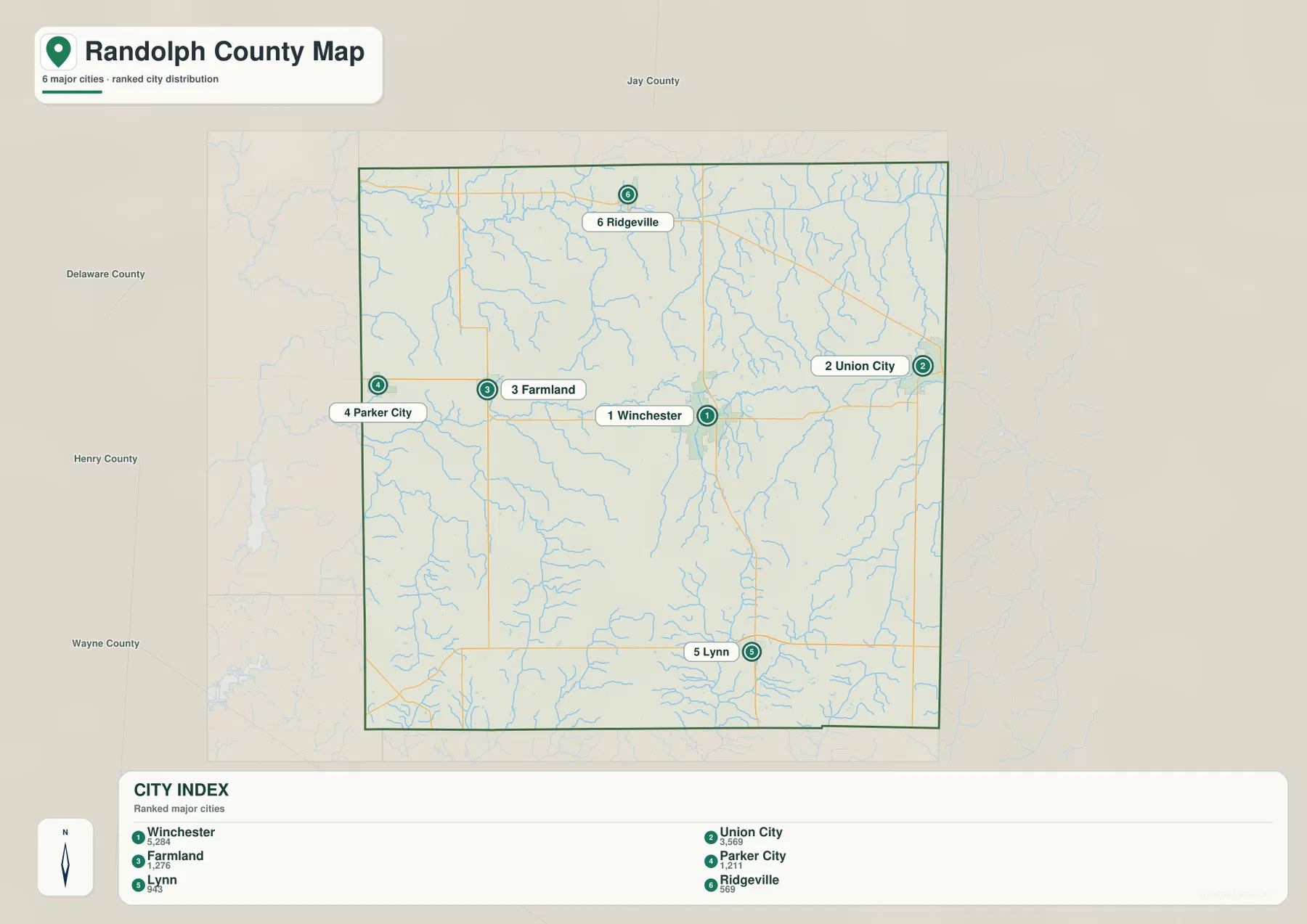
The CITY INDEX places Winchester first, followed by Union City, Farmland, Parker City, Lynn, and Ridgeville. Numeric values also appear beneath the place names, but the supplied chat package does not identify a date or a separate statistical source for those values. For that reason, this article does not present them as current official population. A current Census product is the appropriate source when up-to-date population is required; here, the map is used for the geography it clearly supports—where the highlighted places are and how they relate to one another.
The west-to-east relationship is especially clear. Parker City lies closest to the western side, Farmland is farther inward, Winchester occupies the central-eastern interior, and Union City is close to the eastern boundary. That sequence does not include every important place in the county, and it does not mean all four lie on one identical road line, but it gives a quick sense of the county’s width. Ridgeville and Lynn then add a north–south dimension that prevents the city pattern from being reduced to a single corridor.
Those directions also correspond with changes on the natural maps. Ridgeville points toward the broad lower-colored northern terrain, while Lynn lies in the higher southern half. Union City is near the eastern side where the Little Mississinawa River becomes a distinctive north–south water feature. Winchester remains useful in the center, close to the part of the county where the White River system and its tributaries become visually important. The city map therefore works well as a bridge between roads and physical geography.
Four water regions separate the north, center, east, and southwest
The terrain-and-water map is easier to read when Randolph County is divided into four broad water regions. Across the north, the map labels the Mississinawa River, with Bear Creek and Mud Creek among the nearby tributaries. Through the middle, White River follows a more irregular path and makes a broad bend on the eastern side before continuing southward. Along the east, Little Mississinawa River forms a long north–south feature. In the southwest, Little White River and Whitewater River create two separate named corridors rather than one dominant channel.
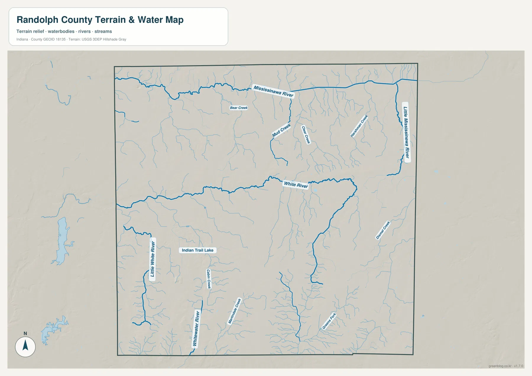
The northern and eastern systems have several useful labels beyond the major rivers. Bear Creek and Mud Creek appear below the northern river, while Silver Creek and Harrison Creek occupy the eastern interior. Their shapes are more irregular than the straight county line and most numbered roads, so the water network cuts across the road framework rather than following it. This difference is especially noticeable around the central and northeastern portions of the map, where short tributaries are dense even when only a few carry large printed names.
Southwestern Randolph County has a different combination of features. Little White River appears along the western side, Whitewater River is farther east, and Indian Trail Lake is labeled between the broader river areas. Cabin Creek is also named nearby. In the southeast, Green Fork and other small streams cross the higher terrain. These features make the south more complicated than a single drainage route; several valleys cut through the uplands and continue in different directions.
The water image is a county-scale reference rather than a flood, parcel, legal-boundary, drainage-design, or navigation product. It is appropriate for identifying where named rivers and creeks lie relative to one another and to the county boundary. Questions about current flooding, legal water ownership, drainage engineering, or safe navigation require dedicated agency information. Used for ordinary map reading, however, the supplied water view clearly shows why the north, center, east, and southwest cannot be described as one continuous river corridor.
The strongest relief change occurs between the northern lowlands and southern uplands
The elevation legend gives Randolph County an actual range of roughly 255 to 378 meters and a mean elevation of 331 meters. Green marks the lower part of this locally scaled surface, shifting through yellow and orange into brown at higher elevations. The largest countywide pattern is immediately visible: broad green terrain dominates much of the north, while orange and brown become much more extensive across the south and southeast. That contrast is stronger than the smaller variations within either half.
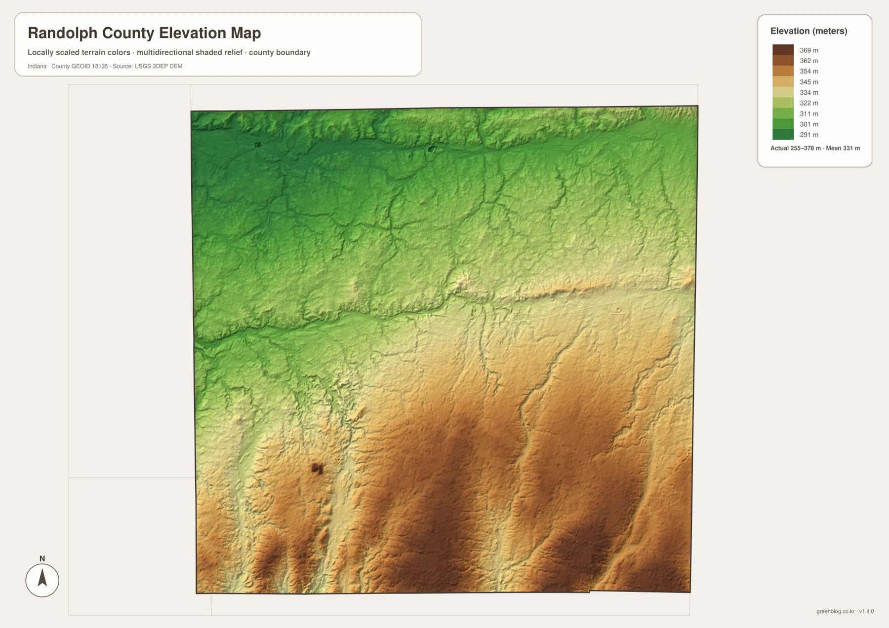
The transition is not a straight east–west boundary. Lower corridors push southward along stream valleys, and narrow drainage cuts remain visible inside the brown uplands. The White River area through the middle is useful for seeing that effect: lower colors follow the valley through terrain that becomes progressively higher farther south. The result is a landscape where “south is higher” is broadly true, but the river and creek valleys still interrupt the uplands with lower routes.
The southwest also contains elevated ground, yet the Little White and Whitewater river corridors carve lower passages through it. In the southeast, numerous narrow valleys dissect the higher surface even though broad brown areas remain dominant. The northern half is not perfectly flat either; subtle ridges and drainage lines can still be seen. What changes is the overall level and extent of the higher colors, which makes the contrast between the Ridgeville direction and the Lynn direction particularly easy to recognize.
This elevation image is intended for regional comparison, not for assigning a survey-grade height to a house, road, parcel, or construction point. The range and mean are useful countywide reference values, but precise site elevations require source data or professional survey work. For a general reader, the most useful interpretation is simple: northern Randolph County is broadly lower, southern Randolph County is broadly higher, and the river valleys create lower corridors through both.
Pick the view that matches the question you are trying to answer
For place names and roads, begin with the general county map. It keeps Winchester, Union City, Farmland, Parker City, Ridgeville, Lynn, and the principal route numbers in one frame, making it the best overview for ordinary orientation. If the secondary roads and stream lines make that view feel crowded, switch briefly to the city map. Its six large labels provide a cleaner way to remember which direction each major place lies from Winchester.
For rivers, the terrain-and-water map is much more informative. It separates the Mississinawa River in the north from White River in the center, Little Mississinawa River on the east, and the Little White–Whitewater river area in the southwest. When the question is elevation rather than water, use the relief map. Its color scale makes the low northern half, higher southern half, and lower stream valleys easier to compare than any road-based map can.
The WebP images on the page are optimized for convenient browser viewing. The downloadable ZIP contains the A3 high-resolution JPG originals for the general county map, city map, terrain-and-water map, and elevation map. Each JPG is 3638 by 2572 pixels. Those originals are the better choice when small stream labels, road numbers, or elevation shading need to remain clear after enlargement or printing.
A simple comparison routine is to keep Winchester as a fixed reference. Find Route 32 and Route 27 on the general map, use the city map to place Union City, the western pair, Ridgeville, and Lynn, then move to the water view to follow the central White River. Finish with the elevation map and compare the greener north with the brown southern uplands. Repeating one familiar part of the county across the four images makes the differences among the map types clear without reducing the article to a repetitive list.
Frequently Asked Questions
Which rivers are the easiest landmarks on the Randolph County water map?
The clearest large references are the Mississinawa River across the north and White River through the center. Little Mississinawa River runs near the eastern side, while Little White River and Whitewater River occupy separate southwestern corridors. Dividing the county into those four water regions is easier than trying to follow every small tributary at once.
Do the numbers in the city index represent current population?
The supplied package does not provide a date or separate statistical source for the numeric values printed under the city names, so this page does not present them as current official population. The city map is used here for its verified visual information: Winchester is central, Union City is east, Farmland and Parker City are west, Ridgeville is north, and Lynn is south.
What is the most important pattern on the elevation map?
The strongest pattern is the change from broad lower green terrain in the north to much more extensive orange-brown high ground in the south and southeast. The legend gives an actual range of about 255–378 meters and a mean of 331 meters. Stream valleys still cut lower corridors through the southern uplands, so the change is broad rather than a sharp straight boundary.
Map File Information
Download the high-resolution JPG originals for the Randolph County general map, city map, terrain-and-water map, and elevation map in one ZIP. The originals are best for enlarging small route and stream labels or preparing an A3 print.
- Printable Size: 3638×2572 px each
Related Maps
Sources and References
The county-specific road, place, water, and elevation descriptions above are based on the supplied Randolph County maps and asset information. The official resources below are useful when current source boundary, hydrography, or elevation data is required.
- U.S. Census Bureau TIGER/Line Shapefiles – official reference data for county boundaries, roads, and places
- USGS National Hydrography – official river and stream data information
- USGS 3D Elevation Program – elevation source data and program information
Green Map creates custom-edited map images using open geographic data sources such as geoBoundaries, Natural Earth, OpenStreetMap, and government open data.
These maps are edited visual materials, not raw data files, and are provided for education, documents, presentations, and graphic reference.