Clark County sits at a striking transition between the Ohio River lowlands and the higher ridges of southern Indiana. Jeffersonville and Clarksville occupy the river edge at the south, while I-65 carries the main north–south road pattern through Sellersburg, Memphis, and Henryville. Farther west, Borden lies in a much more broken landscape of ridges and creek valleys, and Charlestown anchors the central-eastern part of the county near Routes 62 and 3. The maps on this page show those differences in roads, settlements, water, and elevation, and the same map set is available as high-resolution JPG files in a downloadable ZIP.
The county does not have one uniform landscape. Its southern edge is urban and closely tied to the Ohio River, especially around Jeffersonville, Clarksville, and Utica. North of that cluster, development stretches along I-65 toward Sellersburg and Henryville. Charlestown, Otisco, and New Washington lie farther east, where roads spread across a broad interior before reaching the river. West of the interstate, the county boundary pushes outward around Borden into terrain that is visibly rougher on both the water-relief and elevation maps.
Water explains much of the relief. The Ohio River forms the long eastern and southeastern edge, while Silver Creek, Sinking Fork, Fourteenmile Creek, Camp Creek, Bull Creek, and smaller tributaries cut through the interior. Deam Lake and Scottsville Lake appear in the western hills, reinforcing the contrast with the broad river lowlands near Jeffersonville. The elevation map reports an actual county range of about 96 to 314 meters, with a mean near 188 meters, so the difference between the Ohio River corridor and the western uplands is substantial rather than merely visual.
Table of Contents
I-65 links the Ohio River cities with Sellersburg, Memphis, and Henryville
The county overview makes Jeffersonville and Clarksville the easiest starting points. Both sit near the Ohio River at the southern end of the county, and I-65 rises from that urban area through Sellersburg before continuing toward Memphis and Henryville. Underwood appears close to the northern boundary. This sequence gives the western half of Clark County a clear north–south orientation: find the river cities first, then follow the interstate corridor to understand where the next major settlements lie.
The rest of the road pattern is less linear. Borden sits in the western projection of the county and is reached along the Route 60 corridor. Charlestown lies east of Sellersburg, where Routes 62, 3, and 160 help organize the central part of the map. Otisco is north of Charlestown, and New Washington is farther northeast. Route 403 also helps connect the Sellersburg side with the Charlestown area. These roads show why Clark County is better understood as several connected zones rather than as a single strip along I-65.
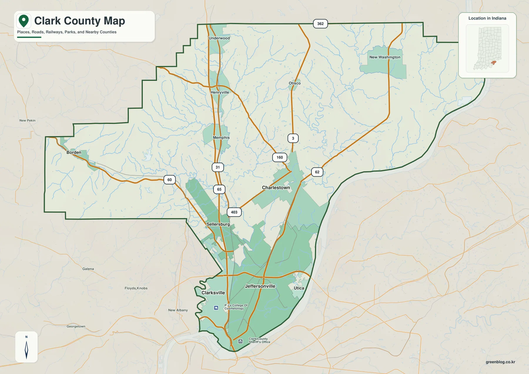
The county boundary also matters. The Ohio River creates a long curved eastern and southeastern edge rather than a straight line. In the west, the county extends outward around Borden in a stepped shape, then narrows again toward the southern urban area. That geometry helps explain why a town can appear close on a statewide map yet still sit in a very different part of Clark County. Using Jeffersonville, Charlestown, and Borden as three reference points makes the unusual outline much easier to remember.
The six-city index separates the southern river cluster from the western and eastern towns
The city-distribution map simplifies the county to six ranked places: Jeffersonville, Clarksville, Sellersburg, Charlestown, Utica, and Borden. Jeffersonville and Clarksville form a tight pair in the south, while Utica sits a short distance east along the Ohio River. Sellersburg is the northern extension of that urban corridor. Charlestown stands farther east in the interior, and Borden is isolated on the western side, making it the clearest contrast to the river cities.
This view is useful because it removes much of the road detail and makes settlement distribution easier to compare. Jeffersonville, Clarksville, and Utica all relate directly to the river edge. Sellersburg sits between the southern urban area and the communities farther north along I-65. Charlestown represents the central-eastern part of the county, while Borden marks the western hills. Returning to the overview after studying this simplified layout makes it easier to see which highways serve each cluster.
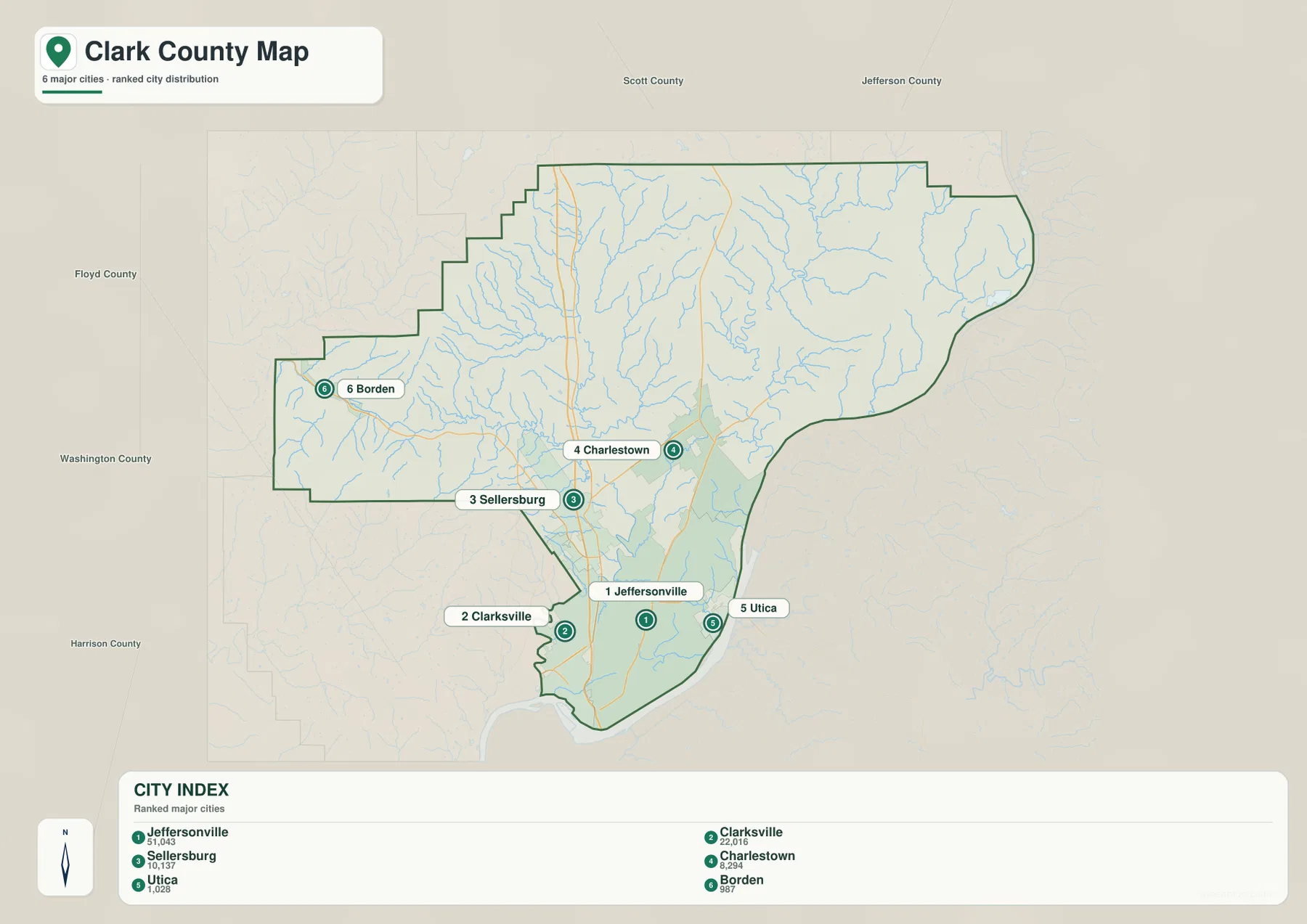
This map does not show travel time or driving distance. Its value is relative position. Jeffersonville and Clarksville are clearly much closer to one another than either is to Borden, and Utica is visibly tied to the Ohio River side of the county. Charlestown is separated from the I-65 line, which helps explain why Route 62 becomes more important east of Sellersburg. For trip planning, use an up-to-date road service; for county orientation, the simplified city view is the faster reference.
The Ohio River is the dominant water boundary, but the interior creeks shape the hills
The terrain-and-water map gives the Ohio River the strongest visual presence. It follows the county’s eastern side and bends around the southern edge below Jeffersonville and Clarksville. Camp Creek and Bull Creek approach the river from the northeast and east, while Fourteenmile Creek cuts through the central-eastern hills. Pleasant Run appears farther south near the river-facing side of the county. These channels correspond to narrow low corridors that are also visible on the elevation map.
Silver Creek is the major internal waterway on the western half of the county. Tributaries join it around Henryville and the central-western area, and Sinking Fork forms another prominent branch. In the Borden section, Muddy Fork cuts across the rougher western terrain. Deam Lake and Scottsville Lake are labeled in this same upland area, while Silver Lake appears farther south. The combination of creeks, lakes, and shaded relief shows that western Clark County is not a smooth plateau; it is divided by many short valleys and ridges.
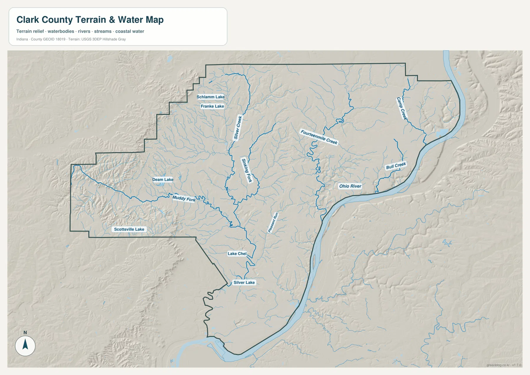
Deam Lake provides a useful real-world reference for the western terrain. Indiana DNR identifies Deam Lake State Recreation Area near Borden, and the supplied map places the lake within the county’s more rugged western relief. That setting contrasts sharply with the broad low ground along the Ohio River. The water map is therefore useful for understanding valley position and watershed context, but it is not a flood-zone map, a channel-depth chart, a navigation product, or a source for legal water boundaries.
A 96–314 m elevation range separates the western ridges from the river lowlands
The elevation map reports an actual Clark County range of about 96 to 314 meters and a mean of roughly 188 meters. The darkest greens hug the Ohio River and extend through the southern lowlands around Jeffersonville and Clarksville. Similar low fingers reach inland along Camp Creek, Bull Creek, Fourteenmile Creek, and other tributaries. This close match between water lines and low elevation helps explain why the eastern side is carved into many narrow valleys even where the surrounding surface is higher.
The highest colors are concentrated in the western projection around Borden and in the northwestern ridges. Brown and dark tan slopes are cut by green creek valleys, creating a much more irregular pattern than the river edge. The Henryville area also shows substantial local relief, while the broad central and northern interior generally sits between the two extremes. Clark County therefore has a strong west-to-east contrast, but the interior valleys prevent it from being a simple high-west, low-east slope.
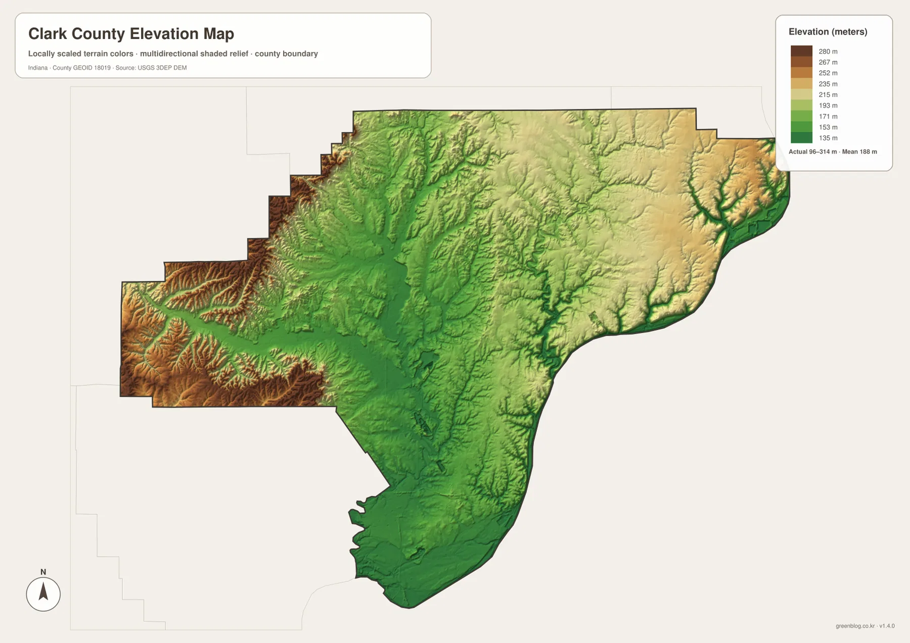
These colors are designed for county-scale comparison, not property-level measurement. A color band represents a range of elevations, and small cuts, embankments, and local slopes can be generalized at this scale. Survey, engineering, drainage, and building decisions require more precise source data. For ordinary map reading, the most useful interpretation is the large contrast: low river land around Jeffersonville and Utica, higher ground toward Borden, and creek valleys that cut through the uplands between them.
Choose the road view for settlements and the relief views for the county’s east–west contrast
Use the county overview when the question is where a place or numbered road lies. It is the best single view for comparing Jeffersonville, Clarksville, Sellersburg, Charlestown, Borden, I-65, U.S. 31, Routes 60, 62, 3, and 160. The city-distribution map is simpler when the goal is to understand how the six highlighted communities are arranged without reading every road. The two views work especially well together in the southern half of the county, where the river cities and interstate corridor overlap.
Use the terrain-and-water map when following Silver Creek, Sinking Fork, Fourteenmile Creek, Camp Creek, or the Ohio River. Then switch to the elevation map at the same location. The creek valleys appear as lower bands, the Ohio River edge becomes a broad low zone, and the western Borden area rises sharply into ridges. This comparison is the most direct way to see why roads and settlements occupy very different terrain within a county that looks compact on a statewide map.
The WebP maps in the article are reduced for fast viewing. If you need larger labels, a printable copy, or an offline reference, the ZIP below contains the original high-resolution JPG versions of all four supplied maps. Each JPG is 2572 × 3638 pixels.
Use these maps for county orientation rather than parcel, flood, or engineering decisions
Each map answers a different county-scale question. The overview combines roads, settlements, boundaries, and waterways; the city view reduces the county to six major places; the terrain-and-water map emphasizes streams and relief; and the elevation map summarizes broad differences in height. Because they prioritize different information, small visual differences between the files are expected. They are complementary reference maps rather than four versions of a legal or survey product.
For parcel boundaries, ownership, official flood determinations, channel conditions, or site-level elevation, use the appropriate government or professional source. The Clark County government site provides local administrative and transportation context, while Census and USGS resources provide authoritative boundary, hydrography, and elevation data. The maps here are best for understanding how Jeffersonville, Charlestown, Borden, the Ohio River, and the western ridges fit together and for choosing the downloadable image that matches your task.
Frequently Asked Questions
Which major Clark County communities are closest to the Ohio River?
Jeffersonville and Clarksville sit directly along the southern river edge, and Utica lies farther east beside the Ohio River. Sellersburg is north of this cluster along the I-65 corridor, while Charlestown is farther inland to the northeast. The county overview and city-distribution map make this river-to-interior relationship easiest to compare.
Why does the Borden area look much higher than Jeffersonville?
The elevation map places Borden in the western uplands, where brown and tan ridges are common, while Jeffersonville lies near the lowest broad zone along the Ohio River. The map’s actual county range is roughly 96–314 meters, so the contrast is large. Western creek valleys cut into the higher ground, creating a more rugged surface than the flatter river lowlands.
Which map is best for locating Silver Creek and Fourteenmile Creek?
The terrain-and-water map is the clearest choice. Silver Creek and Sinking Fork are prominent in the western-central part of the county, while Fourteenmile Creek runs through the central-eastern hills toward the Ohio River. Checking the same locations on the elevation map shows how both creek systems occupy lower corridors within surrounding uplands.
Map File Information
Download the Clark County maps shown on this page as a high-resolution JPG set. The archive is useful for enlarging road and water labels, comparing the Ohio River lowlands with the western ridges, or keeping printable copies offline.
- Printable Size: 2572 × 3638px each
- File Type: ZIP containing 4 JPG files
Related Maps
Sources and references
- Clark County, Indiana official website — county government, transportation, and Ohio River context
- Indiana DNR: Deam Lake State Recreation Area — official information for Deam Lake near Borden
- U.S. Census Bureau TIGER/Line Shapefiles — county boundaries, roads, and place data
- USGS National Hydrography — rivers, creeks, and water-network data
- USGS 3D Elevation Program — elevation and terrain data
Green Map creates custom-edited map images using open geographic data sources such as geoBoundaries, Natural Earth, OpenStreetMap, and government open data.
These maps are edited visual materials, not raw data files, and are provided for education, documents, presentations, and graphic reference.