Logansport is the clearest starting point for reading Cass County, Indiana. Roads converge around the city, the Wabash River crosses the middle of the county, and the Eel River comes down from the northeast to meet it near Logansport. Beyond that center, Royal Center lies to the northwest, Walton and Galveston occupy the southern part of the county, and Onward sits farther east. This page separates those features into four maps so you can examine county boundaries and roads, compare settlement locations, trace rivers and creeks, and see the county’s actual 147–256 m elevation range. The same maps are available below as high-resolution JPG files in a downloadable ZIP.
The river valleys are the strongest physical feature on the map set. On the elevation view, a dark green lowland follows the Wabash across the central part of Cass County, and another low corridor follows the Eel toward Logansport. Higher tan and brown terrain spreads across much of the north and northeast and appears again across broad areas south of the Wabash. That contrast makes the terrain easier to understand than a road map alone: the major rivers occupy lower ground, while many roads and settlements extend outward onto the higher surrounding surface.
The city-connections map gives a second way to orient the county. It uses Logansport as the hub and labels Royal Center at roughly 11 straight-line miles, Walton at about 8 miles, Onward at about 9 miles, and Galveston at about 15 miles. Those values are direct distances rather than driving mileage. They are best used to compare relative location and direction, not to estimate travel time.
Table of Contents
Logansport anchors a road network that reaches four different parts of the county
The county overview places Logansport slightly west of the visual center of Cass County, where the densest group of roads and developed areas appears. Royal Center is northwest of the city, while Lucerne lies farther north near the upper middle of the county. Twelve Mile appears toward the northeast. South of Logansport, Walton and Galveston become the main reference points, and Onward marks the eastern side. Lake Cicott appears on the western edge. Because these places are scattered rather than forming one continuous urban strip, Logansport works well as a central reference without hiding the importance of the outer communities.
Several numbered routes make the settlement pattern easier to follow. Route 24 runs east-west through the Logansport area, Route 17 extends north from the city, and Route 16 crosses the northern part of the county near Royal Center. Farther south, Route 218 passes through the Walton area, while Route 35 is a useful line for locating Walton and Galveston in the southeast. The map also shows Routes 25, 125, and 329 around the central area. Rather than listing every road, it is more useful to notice how the network changes from the tight Logansport cluster to the straighter, more widely spaced roads outside the city.
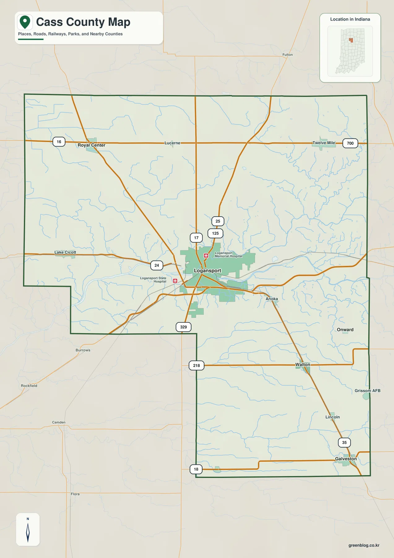
The county outline itself is worth noticing. The northern half is broad, but the western boundary steps inward south of Logansport, leaving a narrower southern extension on the eastern side. That irregular shape changes how far the southern communities feel from the northwestern corner even when they are in the same county. Starting at Logansport, tracing Route 24 east and west, then following the southern roads toward Walton and Galveston gives a simple mental framework for the entire outline.
Royal Center, Walton, Onward, and Galveston spread from 8 to 15 direct miles from Logansport
The city-connections map removes much of the local road detail and emphasizes distance and direction. Royal Center is northwest of Logansport and is labeled at about 11 miles. Walton lies to the southeast at roughly 8 miles, while Onward is about 9 miles to the east. Galveston sits farther toward the southeastern edge and is labeled at approximately 15 miles. The pattern shows that Cass County’s communities are distributed in several directions from the hub rather than arranged along a single corridor.
These connector values are straight-line measurements. A driver traveling from Logansport to Galveston or Royal Center must follow the actual road system, so road mileage can be longer than the number printed on the map. For map reading, however, direct distance is useful because it removes route choice from the comparison. Walton and Onward fall into a similar distance band even though they lie in different directions, while Galveston is clearly farther from the hub and Royal Center defines the northwestern side of the settlement pattern.
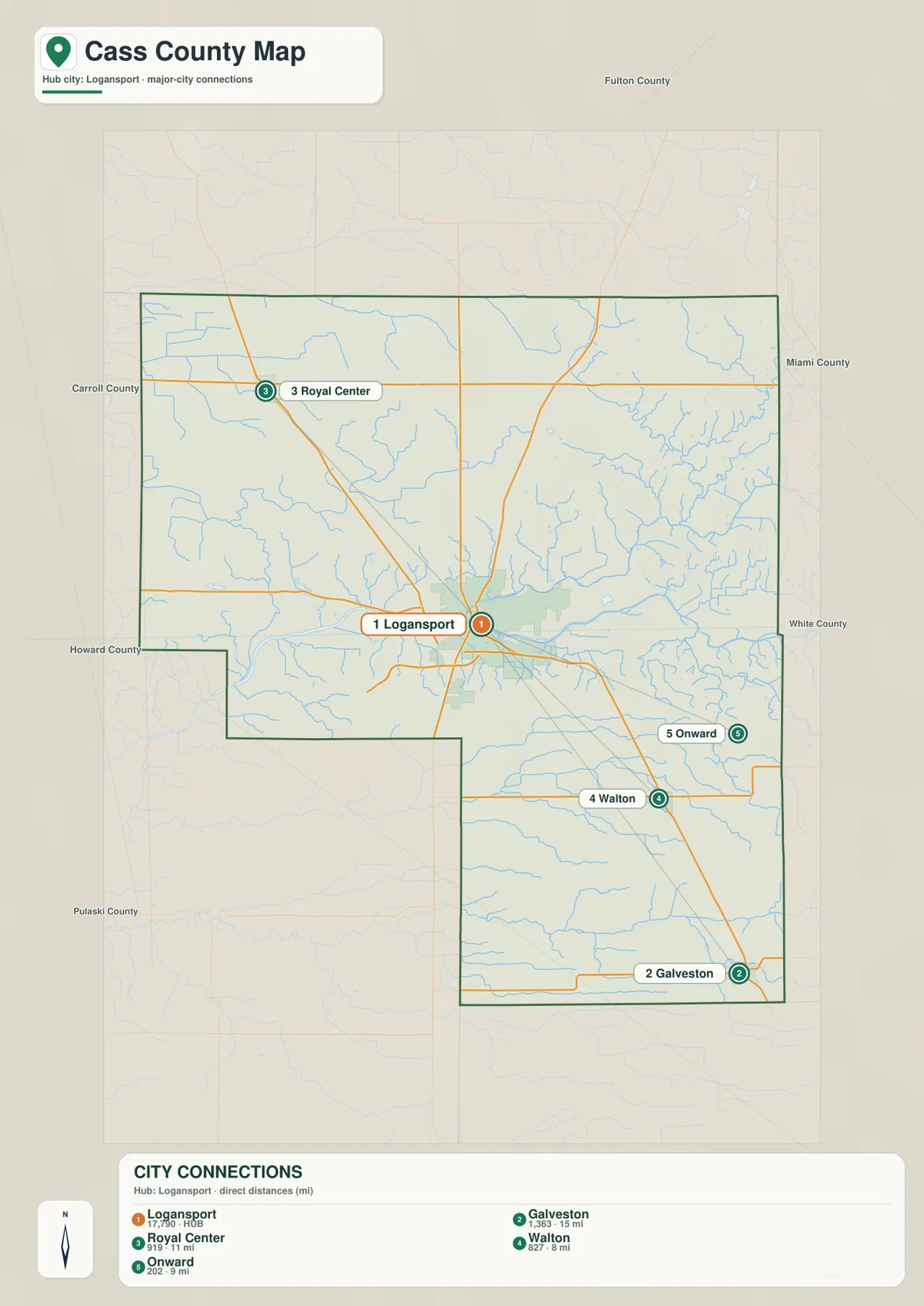
Putting the city map beside the road map adds practical context. Royal Center aligns with the northern Route 16 corridor, Walton sits near the southern Route 218 corridor, and Galveston helps define the county’s southeastern corner. Onward provides an eastern reference outside the Logansport urban area. Those place-road pairings make the map easier to remember than a sequence of route numbers on its own.
The Wabash and Eel rivers meet near Logansport while smaller creeks divide the outer townships
The terrain-and-water map makes the Wabash River the dominant line through central Cass County. It crosses the county through the Logansport area and forms a broad low corridor that is also obvious on the elevation map. The Eel River approaches from the northeast and joins the Wabash near Logansport. This meeting of two major rivers helps explain why the central part of the county has such a strong water signature compared with the more finely divided creek network farther north and south.
In the northeast, East Branch Twelve Mile Creek and Goose Creek appear among a dense set of smaller channels feeding toward the Eel system. West of Logansport, Crooked Creek and Lake Cicott provide useful landmarks, while Little Indian Creek is labeled farther northwest. South of the Wabash, Little Rock Creek and Rock Creek cross the middle of the southern section. Little Deer Creek and Deer Creek extend across the lower part of the county, and Harness Ditch appears near the southern edge. Together these labels show that the county is not defined only by its two large rivers; smaller streams cut many additional low routes through the landscape.
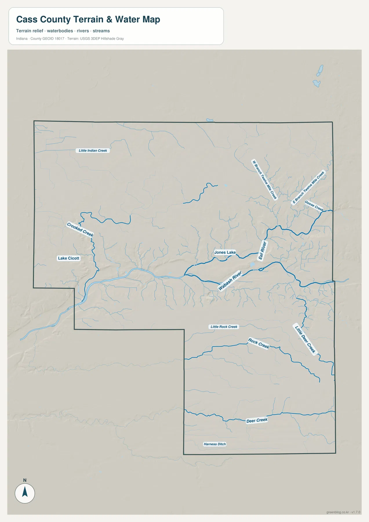
This is a reference map for location and terrain, not a flood map or a navigation chart. A stream line does not mean all nearby land has the same flood exposure, and the map does not provide channel depth, current speed, navigability, or legal water boundaries. Its strength is comparison: you can see how the Wabash and Eel dominate the central county while Deer Creek, Rock Creek, Crooked Creek, and other smaller channels occupy separate parts of the landscape.
The 147–256 m elevation range is shaped by a low central river corridor
The elevation map reports an actual county range of approximately 147 to 256 meters and a mean elevation of about 223 meters. The lowest colors form a long green corridor along the Wabash River. A second low branch follows the Eel River toward Logansport, where the two valleys widen and merge visually. That green network is the easiest feature to match between the water map and the elevation map.
Away from the major river valleys, the county rises. Tan and brown colors cover much of the northern and northeastern area and reappear broadly across the southern section. Deer Creek and several smaller streams create narrower lower strips inside that higher ground, but none forms a valley as broad as the Wabash corridor. The result is a landscape with a distinct low center and higher surrounding surfaces rather than a completely level plain.
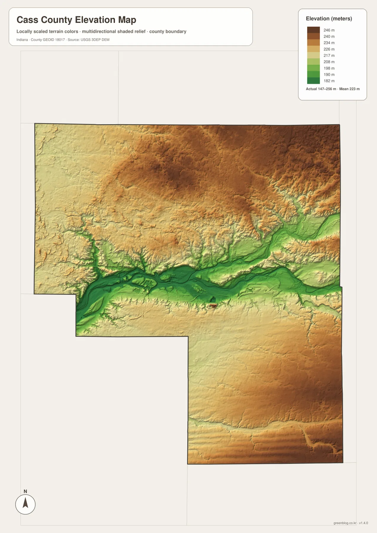
The elevation colors are intended for county-scale comparison. They should not be treated as survey measurements for a property, road project, drainage design, or building site. A single color band covers a range of elevations, and the shaded surface is generalized so that broad relief is readable at this scale. For practical map use, the important point is the relative contrast between the Wabash–Eel lowlands and the higher areas away from those valleys.
Choose the map by task rather than trying to read every layer at once
Use the county overview when the main question is where a town or road lies. Logansport, Royal Center, Walton, Galveston, Onward, Routes 24, 16, 35, and 218 can be compared in one view. Use the city-connections map when the goal is simpler: compare how far the four selected communities lie from Logansport without the distraction of local street detail. Because those connectors are straight-line distances, the map is best for orientation rather than trip planning.
The water map is the better choice for following the Wabash, Eel, Deer Creek, Rock Creek, and the smaller channels. After locating a stream there, switch to the elevation view to see whether it occupies one of the county’s lower corridors. This two-map comparison is especially useful around Logansport, where the Wabash and Eel valleys meet, and in the south, where Deer Creek makes a narrower depression across otherwise higher ground.
The WebP images in the article are reduced for fast on-page viewing. If you need larger labels, an image for printing, or a local copy for classroom and reference use, the ZIP below contains the original high-resolution JPG versions of all four supplied maps. Each JPG is 2572 × 3638 pixels.
These maps are for county orientation, not parcel, flood, or engineering decisions
Each map has a different purpose. The overview combines boundaries, roads, and places; the city-connections view simplifies settlement relationships; the terrain-and-water map emphasizes rivers and creeks; and the elevation view summarizes broad differences in height. Small differences in line detail or visual emphasis between the maps do not mean the files disagree. They are separate views of the same county built for different questions.
For legal parcel boundaries, property ownership, flood-risk determinations, or site-level elevation, use the relevant official source rather than these generalized county graphics. The Cass County government site provides access to its GIS Mapping service, while Census and USGS resources provide official boundary, hydrography, and elevation data. These page maps are most useful for understanding the county at a glance and selecting the downloadable image that matches your task.
Frequently Asked Questions
Are the distances from Logansport to Royal Center, Walton, Onward, and Galveston driving distances?
No. The city-connections map shows straight-line distances of about 11 miles to Royal Center, 8 miles to Walton, 9 miles to Onward, and 15 miles to Galveston. Actual road mileage can be longer because a trip must follow the road network. Use the connector values to compare relative location, not to estimate driving time.
Which map best shows where the Wabash and Eel rivers meet?
The terrain-and-water map is the clearest choice. It shows the Wabash crossing the middle of the county and the Eel approaching from the northeast to join it near Logansport. The elevation map adds useful context because the same river corridors appear as low green valleys. Neither map should be used as a flood-zone or navigation product.
What is the main elevation pattern in Cass County?
The map shows an actual range of roughly 147–256 meters with a mean near 223 meters. The broadest low area follows the Wabash River, with another low branch along the Eel River. Higher terrain becomes more common away from those valleys, especially across much of the north, northeast, and southern section.
Map File Information
Download the Cass County maps shown on this page as a high-resolution JPG set. The ZIP is useful when you need larger road, place, river, and elevation labels or want files for offline viewing and printing.
- Printable Size: 2572 × 3638px each
- File Type: ZIP containing 4 JPG files
Related Maps
Sources and references
- Cass County, Indiana official site — county government information and access to GIS Mapping
- Cass County Visitors Bureau — local information for Logansport, Galveston, Onward, Royal Center, Walton, and county recreation
- U.S. Census Bureau TIGER/Line Shapefiles — county boundaries, roads, and place data
- USGS National Hydrography — rivers, creeks, and water-network data
- USGS 3D Elevation Program — elevation and terrain data
Green Map creates custom-edited map images using open geographic data sources such as geoBoundaries, Natural Earth, OpenStreetMap, and government open data.
These maps are edited visual materials, not raw data files, and are provided for education, documents, presentations, and graphic reference.