Washington County lies in southern Illinois, with Nashville near the center, smaller communities spread toward the county edges, and higher ground across much of the east. This page provides a direct ZIP download of the matching high-resolution Washington County JPG map files, while the WebP previews below let you check Nashville, Okawville, Hoyleton, Irvington, Ashley, numbered roads, county boundaries, creeks, small lakes, and elevation before downloading. The original-size JPG files are intended for printing, teaching, presentations, or closer study when the web previews are not large enough.
Nashville is the easiest place to use as an orientation point. On the general county map, north-south and east-west routes meet around the city, and Washington County Hospital is marked just to the south. Okawville lies to the northwest, New Minden and Hoyleton are farther north, Irvington and Richview are close to the eastern edge, and Ashley, Radom, and Du Bois form another group toward the southeast and south. Because the settlements are spread across the county rather than clustered in one compact urban area, roads and waterways provide useful reference lines between them.
The physical landscape adds another clear pattern. Lower green terrain dominates much of the west and northwest on the elevation map, while broad areas of tan and brown cover the eastern half and especially the southeast. The water map helps explain those color changes: Elkhorn Creek crosses the western side, Little Crooked Creek descends from the north, and Beaucoup Creek and the Little Muddy River occupy lower corridors in the east and southeast. Reading the maps together gives a more complete picture than simply listing the map types one by one.
Table of Contents
Nashville as the road reference point for the county
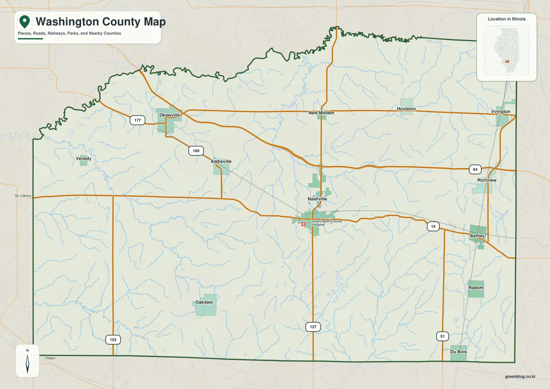
The general map places Nashville close to the center of Washington County and shows several major routes meeting around it. Illinois Route 127 runs north and south through the Nashville area, continuing toward New Minden in the north and toward the southern county boundary. Route 15 heads east from Nashville toward Ashley, while an east-west road extends across the central county toward the western side. Starting at Nashville and following these lines makes it easy to understand how the county’s scattered communities relate to one another.
Okawville occupies the northwestern part of the county, where Routes 177 and 160 are labeled nearby. Addieville is southeast of Okawville. Across the northern half, New Minden is followed eastward by Hoyleton and Irvington, with Irvington very close to the county’s eastern boundary. Richview lies south of Irvington near Route 64. Farther south, Ashley is tied to Route 15, and Radom and Du Bois continue down the eastern side. These labels provide a practical way to trace a trip or compare locations without treating the map as a turn-by-turn navigation product.
The western and southwestern parts of the county include places such as Venedy and Oakdale that sit away from the most prominent numbered routes shown on the map. In those areas, the smaller roads and blue stream lines become more useful for orientation. The eastern side has a different visual character because Ashley, Richview, Irvington, and the stronger north-south road line are easier to pick out. The purpose of the map is not to show current construction or every local road, but to give a county-scale view of how named places, major roads, streams, and the boundary fit together.
Neighboring counties give another layer of orientation. The city-distribution map labels Clinton County to the north, Jefferson County to the east, and Marion County farther along the eastern and southeastern side. St. Clair County is west of Washington County, while Perry and Randolph Counties appear toward the southwest. These surrounding names are especially useful for communities near the edge, such as Okawville in the northwest and Irvington or Ashley in the east.
A central county seat with smaller communities toward the edges
The city-distribution map reduces road detail and highlights six selected communities: Nashville, Okawville, Wamac, Irvington, Hoyleton, and Ashley. Nashville is ranked first and sits near the center. Okawville is in the northwest, while Hoyleton and Irvington lie across the northern to eastern side. Ashley is clearly separated to the southeast. Wamac appears at the northeastern edge of the mapped county area. The value of this map is the simplified placement of the selected communities rather than a complete inventory of every incorporated place.
That distribution matters because Washington County does not read as a single large city surrounded by close suburbs. Nashville is the central administrative reference point, but several of the other labeled communities lie much closer to the county boundary than to the center. Okawville is near the northwest edge, Irvington is near the east boundary, and Ashley occupies the southeast. The pattern makes the road network important: each settlement connects into a broader county rather than merging into one continuous built-up area.
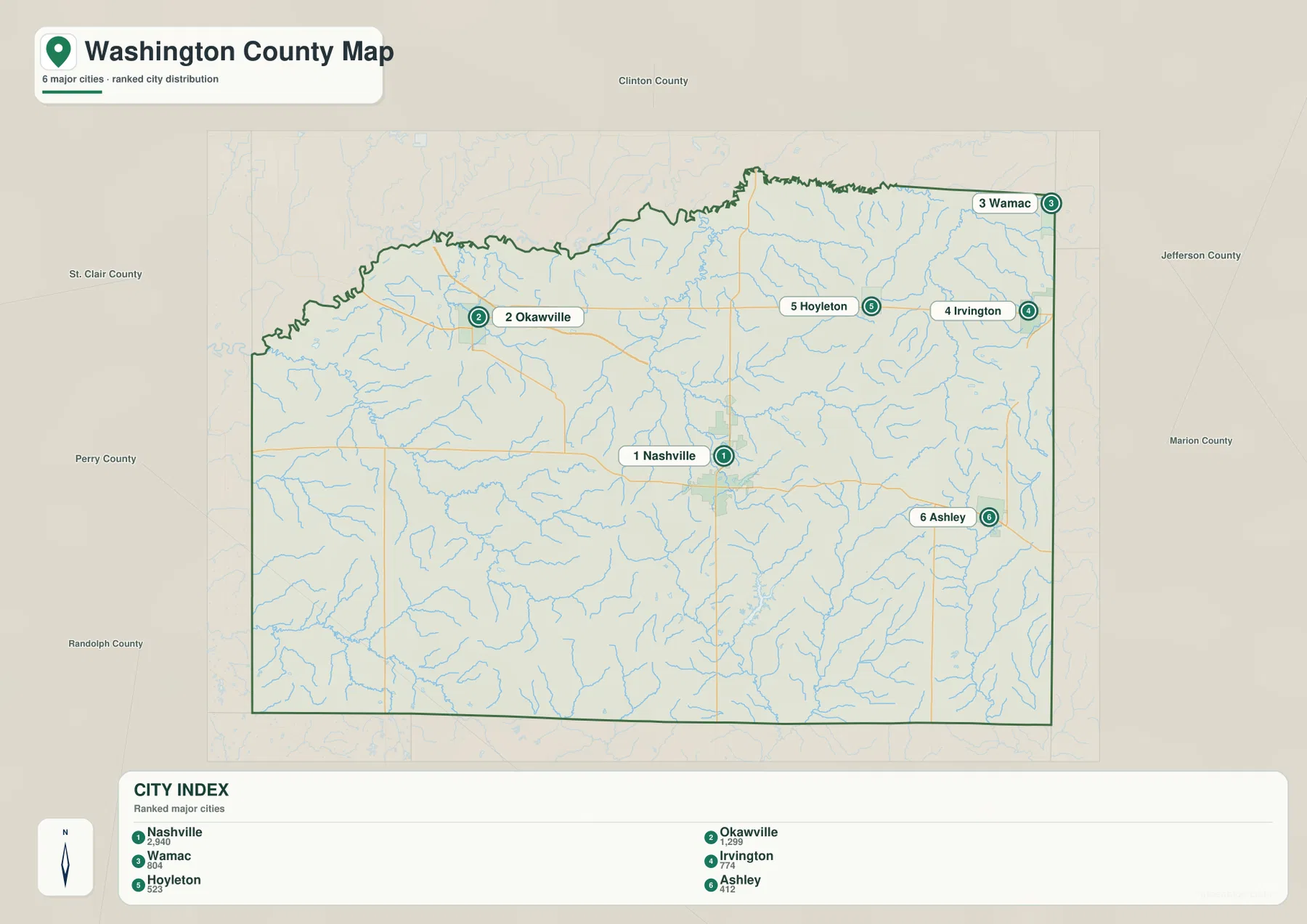
The labels outside the boundary help establish direction without adding more road clutter. Clinton County is directly north, Jefferson County is to the east, and Marion County lies toward the east and southeast. St. Clair County is west, with Perry and Randolph Counties to the southwest. If you are studying a community close to an edge, these surrounding counties can be more informative than a compass direction alone because they show what lies immediately beyond Washington County.
Washington County’s official history identifies Nashville as the county seat, a role it has held since the nineteenth century. That makes Nashville a logical anchor when comparing the maps. Still, the general county map should be used alongside the city-distribution map because it includes more named places, including Addieville, New Minden, Richview, Radom, Du Bois, Venedy, and Oakdale. The simplified city view is best for distribution, while the general map is better when you need a broader set of local names and road references.
Elkhorn Creek, Beaucoup Creek, and the Little Muddy River
The terrain-and-water map shows a dense network of small streams, but several named waterways stand out. Elkhorn Creek begins near the northwestern side around Calamus Lake and bends generally southeastward across the western and south-central part of the county. Mud Creek is emphasized along the southwestern edge. Little Crooked Creek descends from the northern boundary, and farther east, Beaucoup Creek and the Little Muddy River form strong north-south drainage lines. The many thin tributaries between them show how finely divided the county’s local valleys are.
Middle Creek crosses the eastern half, feeding into a landscape where short tributaries repeatedly join the larger channels. Beaucoup Creek is especially prominent in the southeast, while the Little Muddy River runs close to the eastern county boundary. Comparing this map with the location map is useful around Ashley and Radom, where the road-and-town view alone does not show how much the surrounding terrain is shaped by creek valleys. In the west, Elkhorn Creek provides a similar natural reference for the lower-lying terrain.
Several small lakes are named as well. Swan Lake, Clear Lake, and Calamus Lake are grouped in the northwest, with Race Kremmers Lake a little farther east. Golf Course Lake appears near the center, while Lanes Lake and Hickory Lake are farther south. Washington County Lake is also labeled in the south-central area. None dominates the county at this scale, but together they make useful local landmarks and help distinguish one drainage area from another.
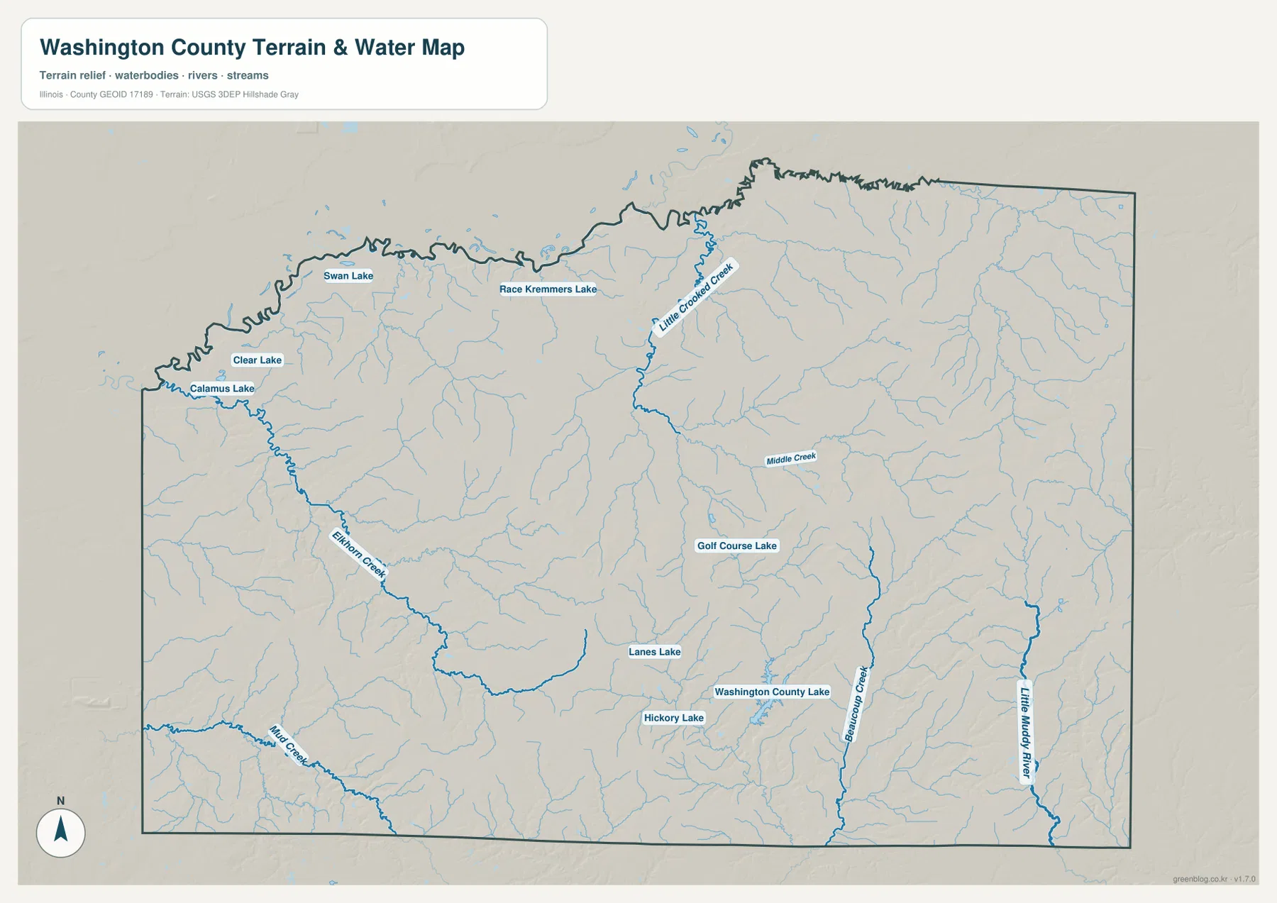
This map is intended for geographic reference rather than flood, parcel, or navigation decisions. A low creek valley shown here does not by itself establish whether a particular property is in a flood zone, where a legal boundary lies, or whether a channel is suitable for access. Those questions require the appropriate official flood maps, parcel records, or field information. Here, the map is most useful for following named waterways and seeing how they occupy the lower parts of the county’s terrain.
Relief from about 117 to 183 meters rises toward the east
The elevation legend gives an actual Washington County range of roughly 117 to 183 meters, with a mean near 148 meters. Green represents lower ground, while yellow, tan, and brown mark progressively higher terrain. The overall contrast is easy to see: much of the west and northwest stays green, while the eastern half contains broad belts of higher ground. The southeast is particularly prominent, with extensive brown slopes cut by narrow green valleys.
The eastern uplands are not one smooth plateau. Numerous drainage cuts divide them into smaller ridges and hills. In the northeast and east-central areas, thin green corridors extend into the tan terrain, and the same pattern becomes even stronger in the southeast. When the elevation map is compared with the water map, many of those lower corridors line up with Middle Creek, Beaucoup Creek, the Little Muddy River, and their tributaries. Elkhorn Creek also follows a noticeably lower path through the western part of the county.
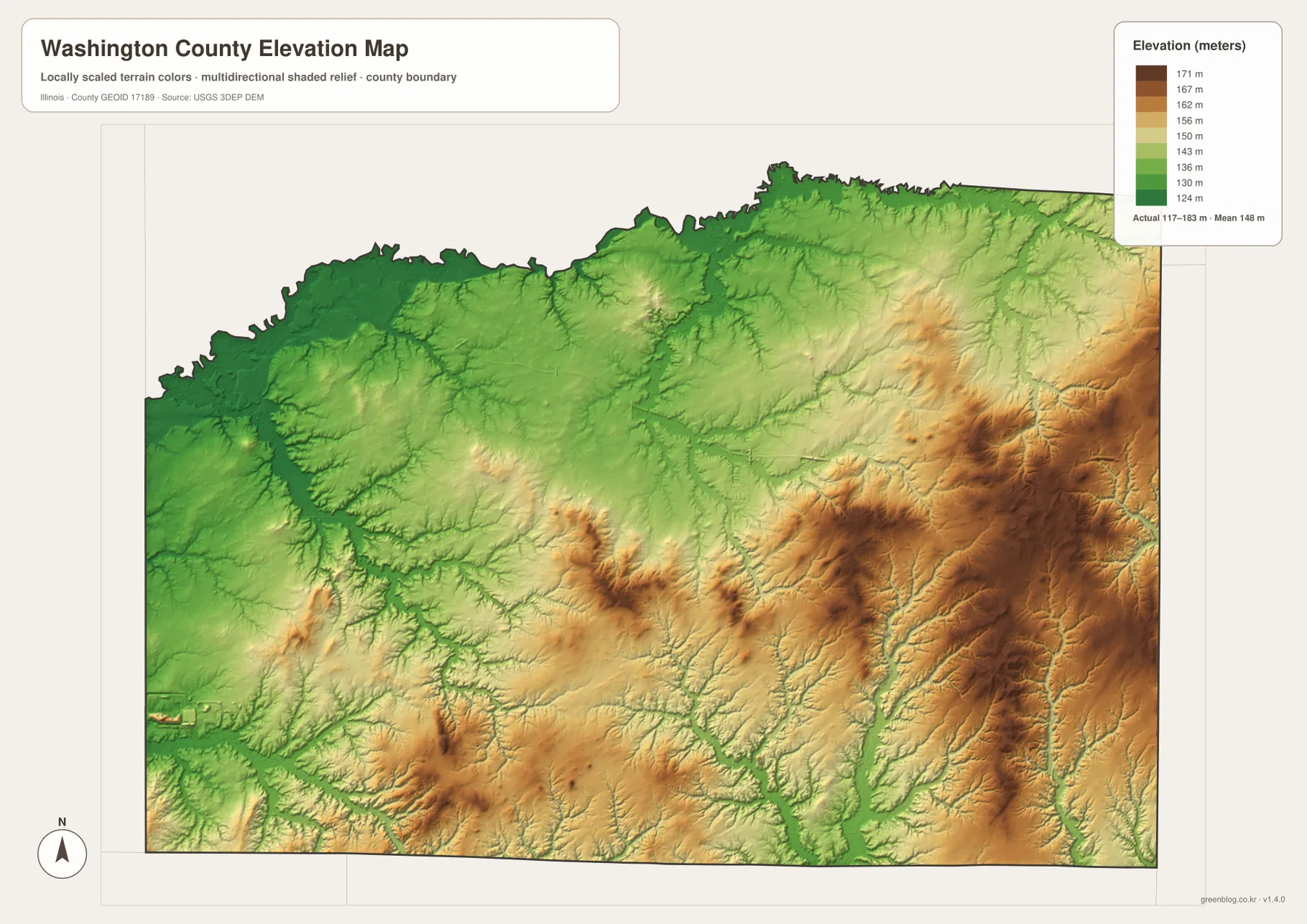
The elevation pattern also adds context to the settlement map. Nashville lies in relatively moderate terrain near the county center. Moving east toward Ashley and Radom, higher colors become more common, while the Okawville and northwestern area sits within a broader zone of lower green terrain. This does not mean every road steadily climbs from west to east, because the creek valleys repeatedly cut through the higher ground, but it does explain why the eastern side looks much more textured on the shaded-relief map.
The elevation surface is generalized for county-scale viewing. It is useful for comparing broad height differences, recognizing creek valleys, and seeing where higher hills are concentrated, but it should not replace a survey or engineering-grade elevation measurement. Building design, drainage calculations, legal boundary work, and site construction require more precise sources. For ordinary geographic study, however, the map clearly shows that Washington County’s relief is uneven and that the eastern half is generally higher than the west.
Which map is most useful for a specific task?
Use the general county map first when you need to locate a town, numbered road, or county edge. Nashville provides the central reference, and from there you can trace routes toward Okawville, Hoyleton, Irvington, Ashley, and the smaller communities shown across the county. If the question is simply where the selected major communities sit relative to the county center and neighboring counties, the city-distribution map removes much of the extra detail and makes those positions easier to compare.
For natural features, the water and elevation maps work best as a pair. Locate Elkhorn Creek, Beaucoup Creek, or the Little Muddy River on the water map, then switch to the elevation map and find the corresponding green valley. The reverse approach works too: if a low corridor or a brown ridge stands out on the elevation map, the water map can show whether a named creek runs through the low ground. This comparison is especially helpful in the eastern half, where the relief is stronger and drainage lines cut deeply into the surrounding higher terrain.
The WebP images in the article are optimized for quick page loading and convenient on-screen viewing. The download below contains the matching high-resolution JPG versions, each measuring 3638 by 2572 pixels. Those files are better when you need to print a map, enlarge labels, place a map into a presentation, or compare details on a large display. The maps emphasize different information, so choosing the right one saves time instead of forcing a road map to answer a terrain question or an elevation map to serve as a place-name index.
Using two maps together can also make a local explanation clearer. A discussion of Nashville and Ashley can begin with the general map and then use the elevation map to show how terrain changes toward the east. A lesson about Elkhorn Creek or the Little Muddy River can combine the water map with elevation to show the valley setting. In that way, the maps complement one another without repeating the same information.
Frequently Asked Questions
Which map makes it easiest to find Nashville and the main roads through Washington County?
Start with the general county map. Nashville is close to the center, Illinois Route 127 runs north and south through the area, and Route 15 heads east toward Ashley. The same map also labels Okawville, Hoyleton, Irvington, Richview, Radom, Du Bois, and other communities, so it is the best first choice when road and place names matter at the same time.
Why does the eastern half look higher and more rugged on the elevation map?
The supplied elevation map shows broad areas of higher tan and brown terrain in the east and southeast, while much of the west and northwest is lower and greener. Creek valleys interrupt the higher ground, especially around Beaucoup Creek and the Little Muddy River. The result is not one continuous high plateau but a series of hills and ridges separated by lower drainage corridors.
Are the downloadable files the same Washington County maps shown on the page?
Yes. The ZIP contains high-resolution JPG versions corresponding to the general county map, city-distribution map, terrain-and-water map, and elevation map. The article uses smaller WebP images for efficient web viewing, while the 3638 × 2572 pixel JPG files are better suited to printing, enlarging labels, and use on larger displays.
Map File Information
The ZIP package contains the high-resolution JPG versions of the Washington County general map, city-distribution map, terrain-and-water map, and elevation map shown in this article. Review the web maps above, then use the original-size files for printing or larger displays.
- Included Files: 4 high-resolution JPG maps
- Printable Size: 3638 × 2572 px each
Related Maps
Sources and References
For county background and the official geographic data used as reference points for boundaries, water features, and elevation, see the following sources.
- Washington County, Illinois official history page — county history and Nashville county-seat background
- U.S. Census Bureau TIGER/Line Shapefiles — county boundaries and geographic reference data
- USGS National Hydrography — streams and water features
- USGS 3D Elevation Program — elevation and terrain data
Green Map creates custom-edited map images using open geographic data sources such as geoBoundaries, Natural Earth, OpenStreetMap, and government open data.
These maps are edited visual materials, not raw data files, and are provided for education, documents, presentations, and graphic reference.