Lee County, Illinois, spreads east from Dixon and the Rock River across a broad interior of small towns, creeks, and higher ground. This page uses the four supplied maps to show the county boundary, major roads and communities, the water network, and elevation differences. The same map set is also available as four high-resolution JPG files in one ZIP, which you can download from the map file box below.
Dixon is the most prominent place on the northwest side of the county map, while Amboy sits farther south in the west-central area. Franklin Grove and Ashton form a northern pair farther east, Paw Paw marks the eastern side, and Sublette lies toward the southeast. Several east-west and north-south highways cross between these communities, so the road map gives Lee County a noticeably gridded structure even though streams and terrain are much less regular.
The terrain and water maps add a second layer to that picture. The Rock River passes the Dixon area in the northwest, while the Green River crosses the southern half and is joined by many smaller channels. Franklin Creek, Steward Creek, Willow Creek, and Big Bureau Creek mark other parts of the drainage network. Elevation on the supplied map ranges from about 194 to 304 meters, with lower ground along river corridors and distinctly higher terrain toward the southeast and parts of the eastern edge.
Table of Contents
Dixon, northern routes, and the long east-west shape of Lee County
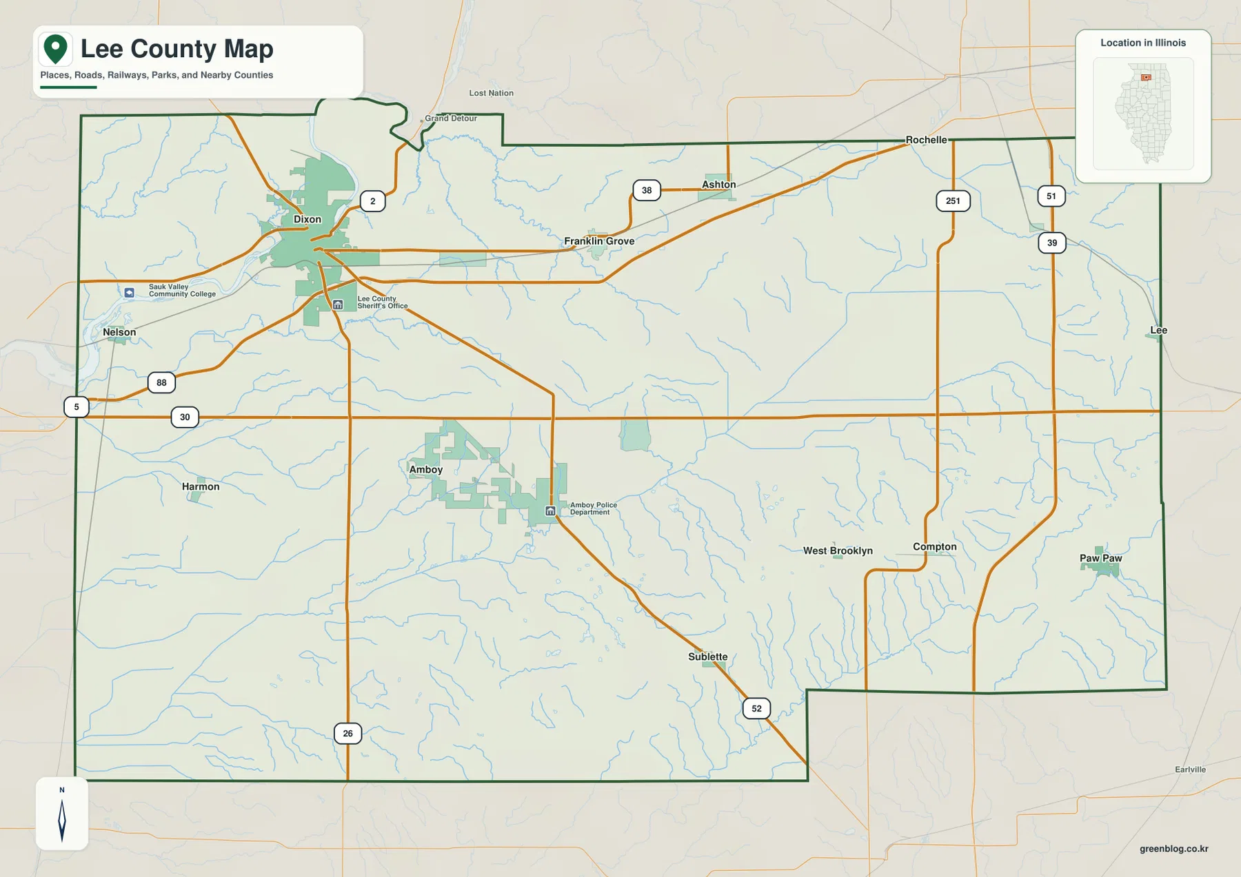
Dixon is the easiest starting point on the general map. It sits in the northwest portion of Lee County where several roads converge close to the Rock River. From there, the northern road network extends toward Franklin Grove and Ashton, while another set of routes heads south toward Amboy. Rochelle appears near the northern edge as an outside reference point, which helps show where Lee County ends and the next community area begins.
Route 30 provides a useful east-west reference across the middle of the county. It enters from the west, passes north of Amboy, and continues toward the eastern side where it meets north-south roads. Farther north, Route 38 connects the area around Franklin Grove and Ashton. Route 52 angles through the southeast near Sublette, so it is especially helpful for understanding why the southern road pattern looks different from the more horizontal routes farther north.
Several north-south routes divide the county into broad western and eastern sections. Route 26 runs through the western half near Amboy, while 251 and the 39/51 corridor appear in the east. These roads make Paw Paw and the eastern side easier to locate relative to Dixon and Amboy. The map is useful for orientation, but it is not a live traffic or navigation product; current driving conditions and turn-by-turn routes should be checked with a current road service.
The county outline is not a perfect rectangle. A small projection and bend interrupt the northern boundary, and the southeastern edge steps inward before continuing east. Those details matter when comparing Lee County with surrounding county maps or when trying to decide whether a road or place falls inside the boundary. Looking at Dixon in the northwest and Sublette in the southeast also shows how far the county extends across both settled road corridors and more open interior land.
How Dixon, Amboy, Franklin Grove, Ashton, Paw Paw, and Sublette are distributed
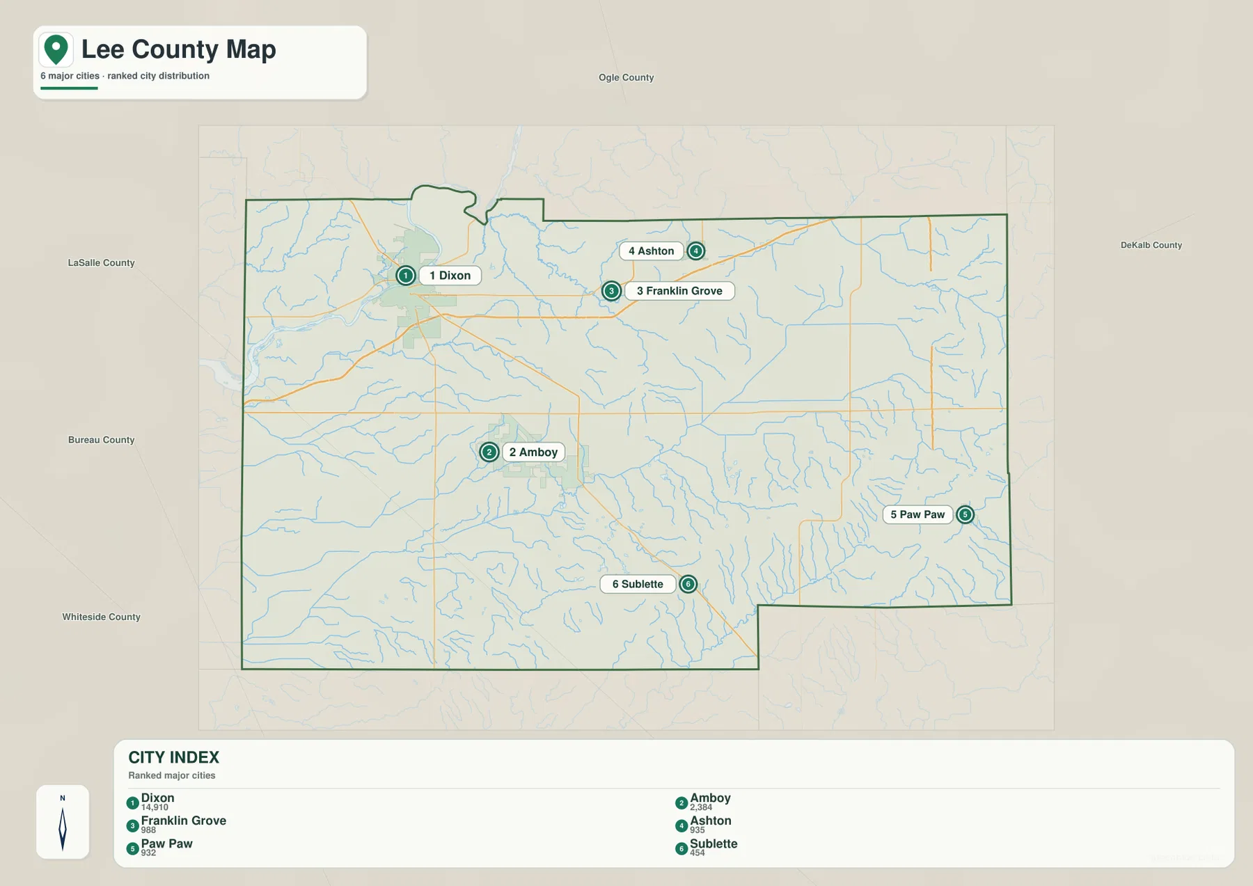
The city distribution map removes much of the road detail so the relative positions of six communities stand out. Dixon is northwest, Amboy is west-central, Franklin Grove and Ashton sit across the north, Paw Paw is near the eastern side, and Sublette is farther south. The arrangement makes it clear that Lee County does not have one continuous urban strip; the named communities are separated by large areas of rural land and waterways.
The CITY INDEX on the map ranks Dixon first and Amboy second. Franklin Grove and Ashton follow as smaller northern communities, while Paw Paw and Sublette serve as eastern and southeastern reference points. The map also prints population-style reference values, but those values should not be treated here as a current census statement. For this article, the useful point is the relative hierarchy and location shown within the supplied map.
Dixon and Amboy are particularly useful as western anchors. Dixon is farther north and closer to the Rock River, while Amboy lies south of the main east-west corridor. Franklin Grove and Ashton form a second cluster to the northeast of Dixon, but Paw Paw is separated from that pair on the far eastern side. Sublette sits still farther south, which makes it a convenient landmark when matching the city map with Route 52 on the general road map.
This map is best for comparing direction and distribution rather than travel distance. It does not show driving times or a route network between the numbered city markers. If you need to plan a trip, use the general county map to identify the road pattern and then consult current navigation data. For classroom, reference, or regional overview work, however, the simplified city layout makes the county’s settlement pattern much easier to explain.
Rock River, Green River, and the smaller creeks across Lee County
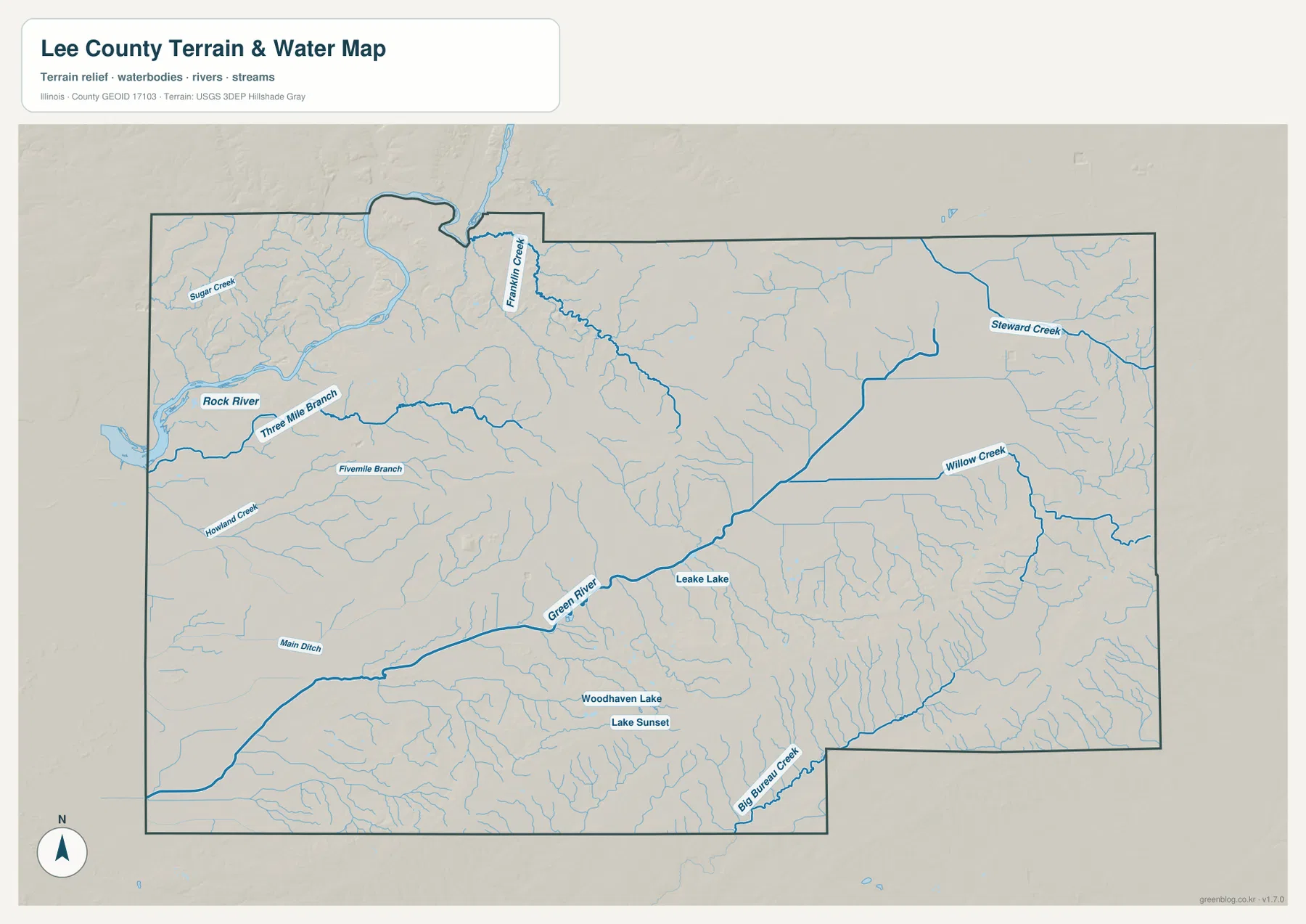
The Rock River is the strongest water feature in the northwest. It passes close to the Dixon area and is joined by smaller channels including Sugar Creek and Three Mile Branch. Fivemile Branch and Howard Creek appear farther south. Seeing these names without the heavy road layer makes the northwest look less like a transportation hub and more like a river valley crossed by a network of smaller streams.
Franklin Creek is prominent in the north-central part of the county. It runs through a landscape that can be matched back to the Franklin Grove area on the road and city maps. Farther east, Steward Creek and Willow Creek mark a different drainage area. The eastern half has fewer large named towns on the simplified city map, yet the water map shows that it contains many branching channels and small tributaries.
The Green River becomes the main reference in the southern half. It enters from the southwest and continues through the south-central interior, with numerous smaller streams feeding toward it. Leake Lake, Woodhaven Lake, and Lake Sunset are also marked nearby. These water bodies are much smaller than the Rock River, but they help orient the viewer within a part of the county where road names alone offer fewer obvious landmarks.
Big Bureau Creek appears near the southeastern boundary and follows a separate course from the Green River. Together, the named rivers and creeks show that Lee County is divided by several drainage corridors rather than one single river system. This map should not be used to determine flood zones, legal water boundaries, or navigation conditions. Its purpose is to show where rivers, creeks, and lakes lie in relation to the county boundary and surrounding terrain.
Elevation from 194 to 304 meters: low river corridors and higher southeastern ground
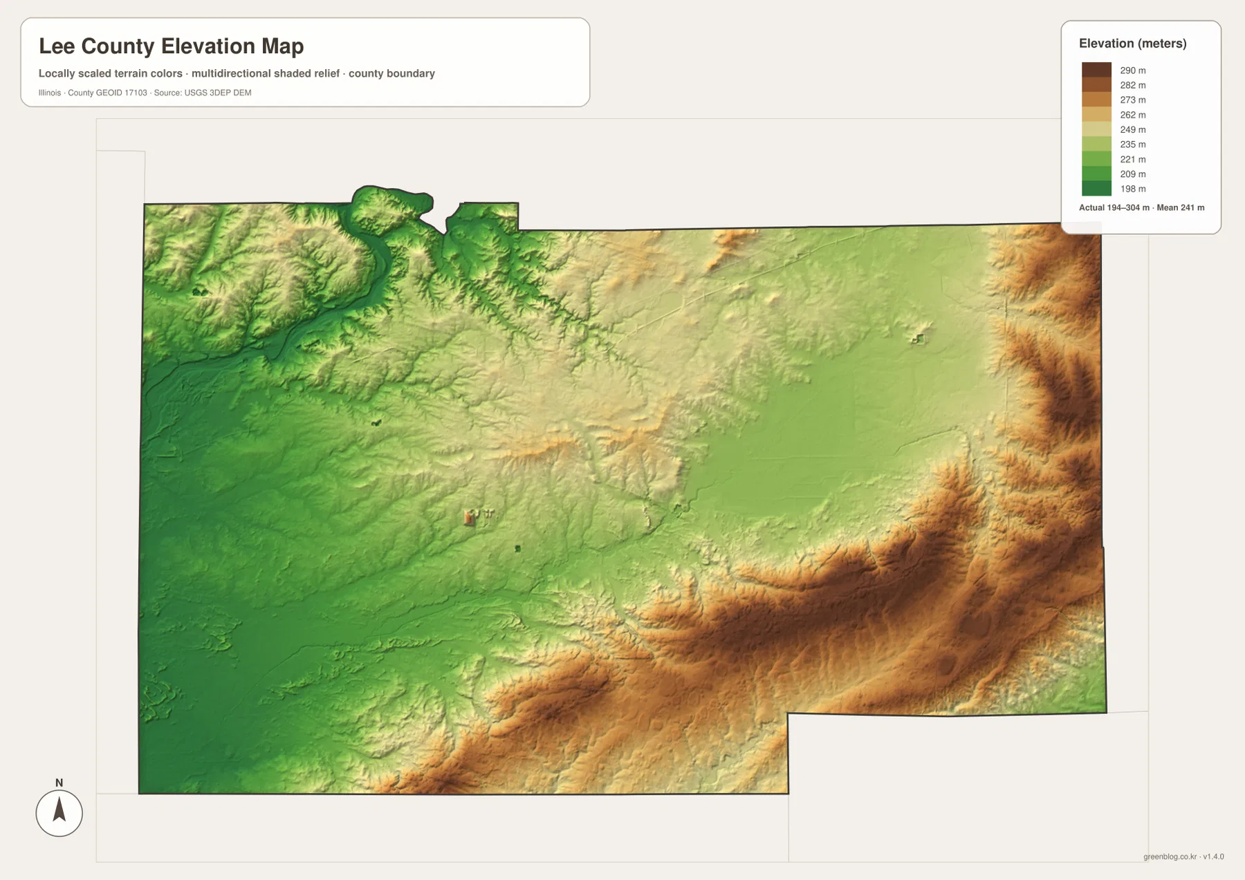
The elevation legend gives an actual range of roughly 194 to 304 meters, with a mean close to 241 meters. The lowest colors are concentrated along the western and northwestern river corridors, especially near the Rock River. On the road map this area can look broadly level, but the shaded elevation surface reveals low valleys bordered by slightly higher ground.
Higher terrain becomes more obvious toward the south-central and southeastern parts of the county. A long band of brown and tan crosses the lower half of the map, and additional high ground appears along the eastern edge. This creates a strong contrast with the green lowlands on the west. Sublette and the southeastern interior lie closer to this higher relief than Dixon does, which helps explain why the two ends of the county look different on the elevation map.
Smaller valleys cut through the higher areas. When the elevation map is compared with the water map, many of those incised green lines line up with the creeks and tributaries shown there. The result is not a single flat plain but a landscape of broad gentle uplands interrupted by lower drainage paths. The effect is especially clear in the southeast, where the contrast between ridges and stream valleys is stronger than in much of the west-central area.
This is a county-scale reference map rather than a survey product. The 194–304 meter range is useful for comparing broad terrain differences, but it should not be used for parcel elevation, engineering design, drainage calculations, or flood-safety decisions. Those tasks require original USGS elevation data or professional field measurements. For general map reading, the key point is the lower Rock River and Green River corridors versus the higher southeastern and eastern ground.
Choosing the right Lee County map for roads, towns, water, or terrain
For a first look at Lee County, start with the general map. Find Dixon, then follow the northern corridor toward Franklin Grove and Ashton before locating Amboy, Paw Paw, and Sublette. That sequence establishes the county’s broad east-west extent and makes the numbered roads easier to understand. It is the most balanced choice when you need towns, roads, the county outline, and some water features together on one page.
If the goal is simply to compare where the main communities sit, use the city distribution map. Its six numbered places remove much of the extra detail and make the west-to-east and north-to-south spacing easier to see. For rivers and creeks, switch to the terrain and water map, where the Rock River and Green River become the dominant references and the smaller named tributaries are easier to follow.
The elevation map is most useful after the other two physical maps are familiar. Compare the low northwest near the Rock River with the higher southeast, then return to the water map and trace the creeks through lower ground. Moving between these views makes it easier to understand why roads, towns, and waterways occupy different parts of the county without turning the article into a technical GIS report.
The WebP images in the article are optimized for fast viewing on the page. If you want to zoom in on small stream labels, inspect road numbers at a larger size, print a map, or place one in a class or presentation document, use the high-resolution JPG archive below. It contains four separate files: the general county map, city distribution map, terrain and water map, and elevation map.
Frequently Asked Questions
Which map is best for comparing Dixon, Amboy, Paw Paw, and Sublette?
The city distribution map is the simplest choice because it emphasizes the relative position of the six highlighted communities. Dixon is northwest, Amboy is west-central, Paw Paw is east, and Sublette is farther south. Use the general county map afterward if you also need the road connections between them.
Where are the Rock River and Green River on these maps?
The Rock River is in the northwest near Dixon, while the Green River crosses the southern half of Lee County. The terrain and water map also labels Franklin Creek, Steward Creek, Willow Creek, Big Bureau Creek, and several smaller lakes and branches, making it the best map for comparing waterways.
Can the 194–304 meter elevation map be used for surveying or engineering?
No. The elevation map is intended for county-wide terrain comparison. It clearly shows lower river corridors and higher southeastern ground, but parcel-level elevation, drainage design, construction, and flood decisions require original high-resolution data or professional measurements.
Map File Information
Download four high-resolution JPG maps of Lee County in one ZIP. The larger files are useful for close inspection, printing, classroom materials, presentations, and local reference work.
- File Type: ZIP archive containing JPG images
Related Maps
Sources and references
- U.S. Census Bureau TIGER/Line Shapefiles – official boundary, road, and geographic reference data.
- USGS National Hydrography – official information for rivers, streams, lakes, and hydrographic data.
- USGS 3D Elevation Program – official USGS elevation and terrain data information.
Green Map creates custom-edited map images using open geographic data sources such as geoBoundaries, Natural Earth, OpenStreetMap, and government open data.
These maps are edited visual materials, not raw data files, and are provided for education, documents, presentations, and graphic reference.