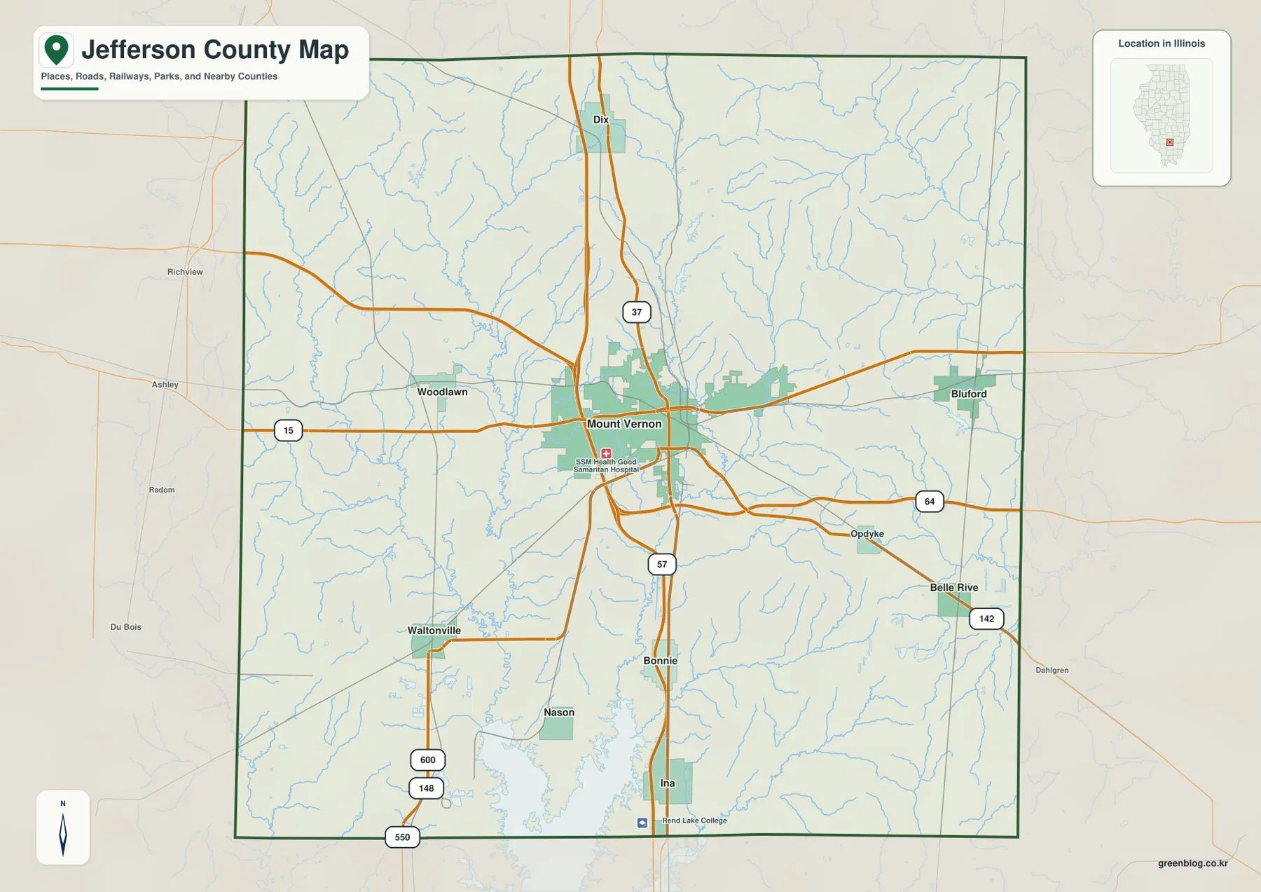
The Jefferson County Illinois Map download on this page includes the full-size JPG files behind the four previews below. Mount Vernon is the main reference point, with I-57 and I-64 crossing the central county, Route 15 extending toward Woodlawn and Bluford, and Route 37 continuing north toward Dix. The companion files add a six-place CITY INDEX, the Big Muddy River–Casey Fork drainage, Rend Lake along the south, and relief labeled from 124 to 195 meters.
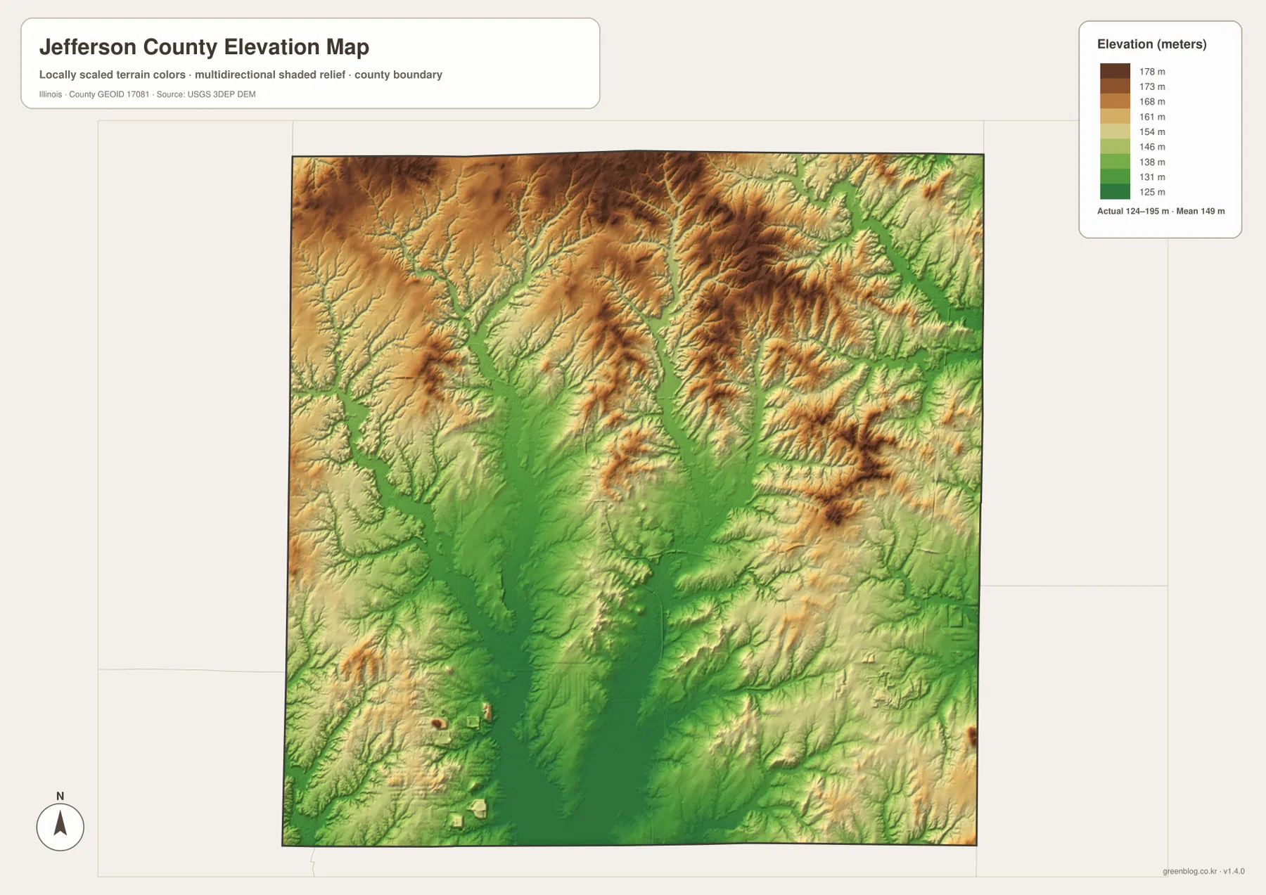
The county is easier to understand when the central low ground is compared with the surrounding hills. Mount Vernon occupies a broad green low-relief zone on the elevation file, while higher brown terrain appears across much of the north and along parts of the east and west. Big Muddy River and Casey Fork cut through that lower interior, and Rend Lake expands across the southern edge. The road, water, and relief files therefore explain different parts of the same central basin.
Table of Contents
Mount Vernon is the road hub between I-57, I-64, and Route 15
Mount Vernon is the easiest location from which to read the general county map. The built-up area occupies the center, with I-57 running north–south and I-64 crossing east–west nearby. Route 15 extends west toward Woodlawn and east toward Bluford, while Route 37 continues north through the Dix corridor. Those four lines create a clear framework before smaller towns and roads are added.
South of Mount Vernon, I-57 leads toward Bonnie and Ina near the southern boundary. Opdyke and Belle Rive sit southeast of the city, with Route 142 visible near Belle Rive. Waltonville and Nason occupy the southwest, where Routes 148, 600, and 550 appear on the supplied road layer. The road network therefore radiates outward from Mount Vernon rather than following a single east–west or north–south pattern.
Dix provides a northern checkpoint, Woodlawn marks the western Route 15 side, and Bluford anchors the east. Moving southeast through Opdyke and Belle Rive reveals a line of smaller places near the eastern edge, while the southwest contains fewer large settlement labels and more water and rural road features.
The City of Mt. Vernon’s official website identifies Mount Vernon as the county seat of Jefferson County. That administrative role matches the map’s visual emphasis: the county’s densest group of roads and the largest built-up area occur at Mount Vernon. The static map does not show live traffic, construction, or road closures, so current driving conditions should be checked separately.
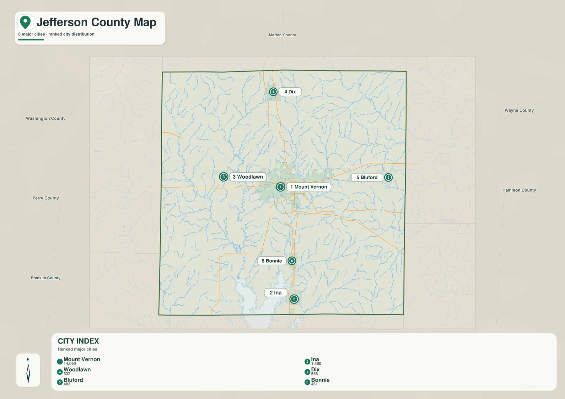
The CITY INDEX spreads from Dix to Ina around Mount Vernon
The ranked-city file selects six communities. Mount Vernon is first with a printed index value of 14,090, followed by Ina at 1,560 and Woodlawn at 632. Dix is shown at 568, Bluford at 483, and Bonnie at 461. These are the values printed on the supplied CITY INDEX and are used here only to explain that map; they should not be presented as current official Census population estimates.
Their positions form a useful compass around Mount Vernon. Dix lies to the north, Woodlawn to the west, and Bluford to the east. Bonnie and Ina are south of the city, with Ina close to the county’s southern boundary. Because the points occupy several directions, the ranked map gives a fast sense of the county’s shape without all of the secondary road and settlement labels.
Outside labels place Marion County to the north, Washington County to the northwest, Perry and Franklin counties to the west and southwest, and Wayne and Hamilton counties to the east. Waltonville, Nason, Opdyke, and Belle Rive remain on the general map but are not part of the six-point index, so the two settlement layers are complementary.
Mount Vernon’s current official city profile lists a separate 2020 Census population, which is one reason not to treat the 14,090 CITY INDEX value as a live demographic figure. The index is best used to compare the map’s six selected places, while current population statistics should come from the city or U.S. Census Bureau.
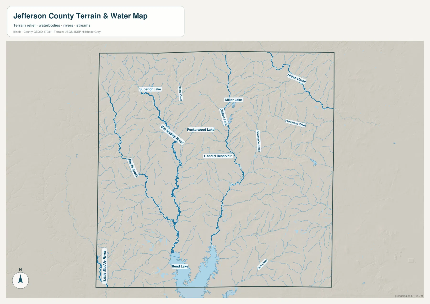
Big Muddy River and Casey Fork lead toward Rend Lake
Big Muddy River is the strongest water feature on the western half of the terrain-and-water map. It descends from the northwest toward the central-southern county, receiving numerous small tributaries. Rayse Creek lies to the west, while Superior Lake and Snow Creek provide northern reference points. These features help explain why the west and northwest are cut by so many small drainage valleys.
Casey Fork is the central-northern water line. It runs south past Miller Lake, with Peckerwood Lake to the west and several tributaries entering from both sides. Sevenmile Creek forms another long north–south drainage farther east. Horse Creek crosses the northeast, Puncheon Creek lies in the east-central section, and the eastern side contains a dense network of smaller channels.
Rend Lake dominates the southern edge of the map. It occupies a broad low area where the Big Muddy system and surrounding tributaries converge. Gun Creek enters the southeastern side of the lake area, and L and N Reservoir appears farther north in the central county. Little Muddy River is visible near the southwest edge, adding another named drainage outside the main Big Muddy channel.
The U.S. Army Corps of Engineers manages Rend Lake and notes that the recreation area is readily reached from I-57 using exits 71 and 77. The county reference map does not show campgrounds, boat ramps, beaches, or trail details, but the federal Rend Lake page provides the current access and recreation information needed for those uses.
The water file is a location map, not a flood or navigation product. It does not contain live lake stage, river stage, flood probability, water quality, boating restrictions, or property boundaries. Big Muddy River and Rend Lake conditions can change, so safety and property decisions require current USGS, USACE, or local-agency data.
The 124–195 meter relief map places Mount Vernon in a lower central basin
The elevation legend prints an actual range of 124–195 meters and a mean of 149 meters. Its displayed color bar runs from roughly 125 to 178 meters. Mount Vernon and much of the central and southern county appear in green, indicating lower terrain relative to the surrounding ridges. Higher tan and brown colors become much more common across the north and along portions of the eastern and western margins.
The low central surface corresponds closely with the Big Muddy River and Casey Fork drainage seen on the water file. Green bands follow creek valleys, while narrow ridges separate individual tributaries. The interior is therefore not a single flat basin; it is a lower region dissected by streams and interrupted by higher ground.
North and northeast of Mount Vernon, the relief becomes more strongly textured. Similar higher ridges appear along parts of the western edge. The southeast remains lower overall, although small hills and narrow drainage cuts continue through the area. The pattern is useful for distinguishing the central river basin from the higher outer county without relying on technical contour lines.
Jefferson County’s official multi-hazard mitigation plan places most of the county within the Big Muddy River watershed and also identifies other watershed divisions. The plan names Rend Lake and Miller Lake among the county’s significant lakes. That official watershed context fits the supplied water and elevation files, which show the broad Big Muddy drainage occupying the center and south.
The relief JPG is intended for broad county comparison rather than surveying or engineering. The 124–195 meter range can describe high and low areas, but it does not certify parcel elevations, road grades, drainage design values, or construction tolerances. USGS 3DEP and professional field measurements are the appropriate sources when precise elevation is required.
Mount Vernon and Rend Lake define the county’s central-to-southern transition
Mount Vernon provides a common reference across all four files. On the road map it is the I-57 and I-64 hub; on the water file it lies near the Big Muddy and Casey Fork drainage; on the relief file it sits within the lower central zone. Holding the city fixed while changing layers makes the county’s road, water, and terrain relationships much easier to understand.
Following I-57 south moves the map through Bonnie and Ina toward Rend Lake. The Corps of Engineers’ Rend Lake page confirms the strong highway connection and provides current recreation information for the lake. On the county water map, the lake’s northern basin occupies a large part of the southern edge, making the Mount Vernon-to-Rend Lake line one of the clearest north–south relationships on the page.
Moving north toward Dix or east toward Bluford tells a different relief story. Higher ridges become more common and smaller tributary valleys break up the landscape. The contrast with the central and southern lowlands explains why the county’s road pattern can look simple while the shaded-relief surface remains visually complex.
Match the Jefferson County file to the question
For towns and highways, begin with the general county file and use Mount Vernon, I-57, I-64, Route 15, Route 37, Dix, Woodlawn, Bluford, Bonnie, and Ina as fixed points. For a cleaner comparison of the six selected communities, the CITY INDEX removes most secondary road and settlement labels.
For drainage, trace Big Muddy River first and then Casey Fork, Sevenmile Creek, Horse Creek, Puncheon Creek, Superior Lake, Miller Lake, and Rend Lake. For terrain, the elevation file immediately separates the lower Mount Vernon–Big Muddy basin from the higher northern, eastern, and western ridges.
The embedded WebP copies are sized for quick browser viewing. The original 3638 × 2572 pixel JPGs provide more room for small road numbers and water labels when enlarged or printed. They are practical for classroom handouts, slide decks, regional comparison sheets, and personal geographic reference.
Legal boundaries, parcels, flood studies, navigation, surveying, and engineering require different source products. Census TIGER/Line supplies official geographic reference data, USGS National Hydrography supplies source water information, and USGS 3DEP supplies elevation data. The four downloadable files here are designed for orientation and visual comparison rather than precision or regulated work.
Full-size Jefferson County JPG files
The ZIP contains the general county map, CITY INDEX map, terrain-and-water map, and elevation map at their original JPG dimensions. Opening them separately makes small labels easier to inspect than in the browser previews, while placing them side by side helps compare one road, town, creek, or lake against the relief surface.
Frequently Asked Questions
Are the CITY INDEX values current official population counts?
No. They are the values printed on the supplied ranked layer: Mount Vernon 14,090, Ina 1,560, Woodlawn 632, Dix 568, Bluford 483, and Bonnie 461. They explain this map’s ordering only. Current official population figures should be checked with the U.S. Census Bureau or the City of Mt. Vernon.
Is all of Rend Lake inside Jefferson County?
The supplied water map shows the northern part of Rend Lake along the southern edge of Jefferson County, but this county image should not be used to determine the full administrative extent of the lake. For current lake boundaries, access points, facilities, and recreation areas, use the U.S. Army Corps of Engineers’ official Rend Lake maps and information.
Can the 124–195 meter relief file be used for surveying?
No. The relief surface compares broad county-scale high and low areas; it does not provide certified point elevations or engineering tolerances. Parcel surveys, construction grades, or drainage design require original elevation data and professional measurement rather than a color readout from this JPG.
Map File Information
The archive contains the Jefferson County general map, CITY INDEX map, terrain-and-water map, and elevation map as high-resolution JPG files.
- Included Files: 4 JPG files
- Printable Size: 3638 × 2572 pixels each
Related Maps
Sources and reference data
- City of Mt. Vernon – About Mt Vernon: official city information identifying Mount Vernon as the Jefferson County seat
- U.S. Army Corps of Engineers – Rend Lake: official Rend Lake information on access, lake operations, recreation, and current notices
- Illinois DNR – Rend Lake State Fish and Wildlife Area: official information on state-managed habitat and recreation lands around Rend Lake near Bonnie
- U.S. Census Bureau TIGER/Line Shapefiles: official geographic boundary and feature reference data
- USGS National Hydrography: source information for rivers, streams, lakes, and related water features
- USGS 3D Elevation Program: source elevation data when more precision is required than the relief JPG provides
Green Map creates custom-edited map images using open geographic data sources such as geoBoundaries, Natural Earth, OpenStreetMap, and government open data.
These maps are edited visual materials, not raw data files, and are provided for education, documents, presentations, and graphic reference.