The downloadable Greene County map files on this page show a part of west-central Illinois where the broad Illinois River lowland meets a much more dissected interior of creeks, ridges, towns, and north-south roads. Carrollton provides a useful central reference, White Hall and Roodhouse line up farther north, Greenfield lies toward the eastern side, and Eldred sits close to the river edge in the west. The four supplied views separate those details so that roads and county limits do not compete with city ranking, water names, or relief. The WebP images below are quick browser previews, while the original 2572 × 3638 pixel JPG files can be downloaded together in a ZIP near the end of the article.
Greene County also has a shape that becomes easier to understand once the Illinois River is located. The western boundary bends for a long distance beside the river and narrows into an unusual southern projection, while much of the eastern side is straighter around Greenfield and Rockbridge. The official county government describes Greene County as having been established in 1821 and identifies Carrollton as the county seat. On the map, Carrollton sits slightly south of center and works well as a point from which to compare the northern towns, the eastern road corridor, and the river-side communities. Outside the county line, places such as Manchester, Jerseyville, and Kampsville help orient the reader to the surrounding part of Illinois.
The general road map and the terrain layers tell different parts of the same story. Route 106 is labeled near White Hall, Routes 108 and 267 appear around Greenfield and Rockbridge, US 67 is marked south of Carrollton, and Route 100 appears near the narrow southwestern end. Waterways are spread through nearly every part of the county, with Apple Creek crossing the interior, Hurricane Creek in the northwest, White Hall Reservoir near the north-central area, and the Illinois River dominating the west. The elevation legend reports an actual mapped range of about 97 to 220 meters and a mean of 166 meters. Those figures explain why the western river margin appears as a broad low strip while ridges become much more prominent to the east.
Table of Contents
Carrollton anchors the road pattern between White Hall and Kane
Start with Carrollton if the goal is to understand the county quickly. A prominent north-south road line runs through or near Roodhouse, White Hall, Carrollton, and Kane, creating a simple reference through the center of the map. US 67 is labeled south of Carrollton, while Route 106 is shown around White Hall. Carrollton also lies on an east-west road that continues toward Eldred on the west and toward Greenfield on the east. Because these routes cross close to the county seat, Carrollton helps organize several otherwise separate parts of the map: the Illinois River side, the northern towns, the eastern settlements, and the southern extension toward Kane.
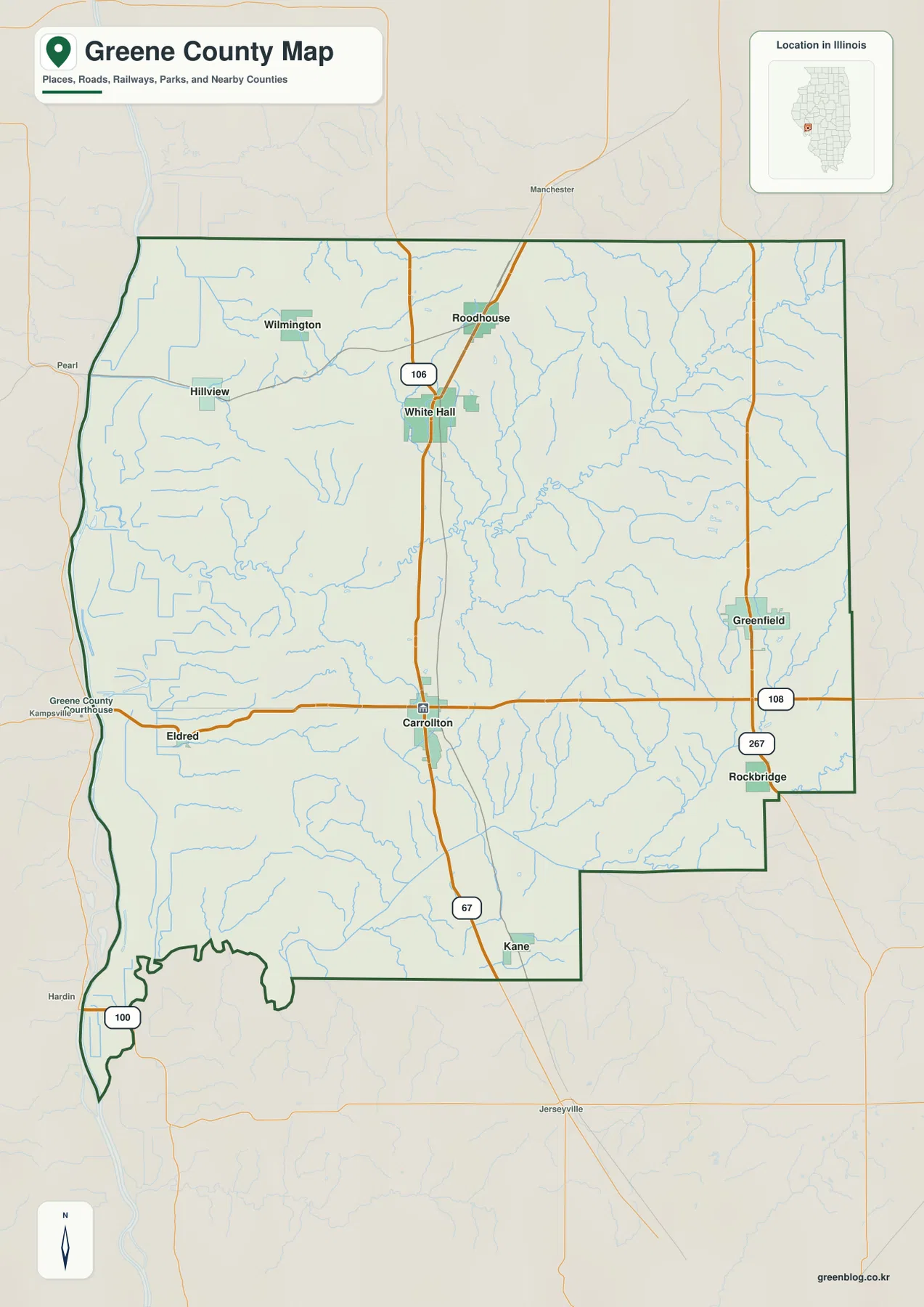
The northern half has its own clear pattern. Roodhouse sits above White Hall, and Wilmington and Hillview are farther west. Route 106 is the most obvious numbered road around White Hall, while the north-south route continues toward Roodhouse and down to Carrollton. Farther east, Greenfield and Rockbridge form a second useful pair near Routes 108 and 267. The map therefore does not show one single compact urban cluster. Instead, several small communities are separated by broad rural spaces and a dense web of minor streams. That separation is important when using the map for county-wide orientation because a short list of town names alone does not convey how widely the communities are spread.
The west side is visually different from the east. Eldred lies close to the Illinois River lowland, while the county boundary follows an irregular river-side shape rather than a straight north-south line. The southwestern end becomes especially narrow, with Route 100 shown near the river and the county line extending into a long point. In contrast, the eastern edge around Greenfield and Rockbridge includes longer straight segments. This difference matters when comparing neighboring counties or printing a boundary reference: Greene County cannot be treated as a simple rectangle. The general map is also the best supplied view for seeing small nearby labels outside the boundary, which help place the county relative to Manchester, Jerseyville, Kampsville, and other surrounding locations.
Six mapped communities spread from the Illinois River side to the eastern boundary
The city view removes most of the road detail and ranks six labeled communities. In the supplied CITY INDEX, Carrollton appears first with 2,479, White Hall second with 2,257, Roodhouse third with 1,544, Greenfield fourth with 1,105, Kane fifth with 201, and Eldred sixth with 172. These are the values printed on the supplied map and should be treated as that map’s ranking index rather than as a substitute for current Census population tables. For geographic orientation, the ranking is still useful because the three largest displayed values belong to places in the central and northern corridor, while Greenfield, Kane, and Eldred mark very different edges of the county.
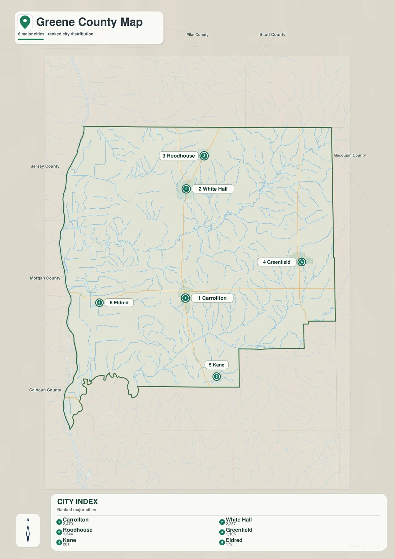
The positions are as useful as the ranking. White Hall and Roodhouse occupy the north-central part of the county, Carrollton sits farther south, and Kane lies near the southern interior. Greenfield is well to the east, while Eldred is close to the western river edge. This arrangement gives a quick sense of how wide the county feels from east to west even without road numbers. County labels outside the boundary add another layer of context: Pike and Scott counties appear to the north, Macoupin County to the east, Jersey and Morgan counties along the west side of the frame, and Calhoun County near the southwest. Those surrounding names are helpful when Greene County is being compared with neighboring county maps.
The ranked city view and the general county view work best as a pair. If the question is simply where Carrollton stands relative to White Hall or Greenfield, the uncluttered city view is easier to scan. If the task is to follow Route 106, locate US 67, or understand how Eldred connects toward the county interior, the general map is more informative. Greenfield and Rockbridge provide a similar example: Greenfield is one of the six ranked places, but Rockbridge appears only on the broader county map. Switching between the two keeps the city labels readable without sacrificing road and settlement detail.
Apple Creek and the Illinois River organize a dense network of smaller waterways
The terrain-and-water map changes the emphasis completely. The Illinois River forms the largest water feature along the western side, while Apple Creek runs through the central part of the county and is joined by numerous smaller channels. Hurricane Creek is labeled in the northwest, Seminary Creek lies near the north-central interior, and White Hall Reservoir is shown close to that area. Bear Creek appears to the east of Apple Creek, with Birch Creek and Hettick Creek farther northeast. In the south and southeast, Macoupin Creek, Taylor Creek, Rubicon Creek, and other tributaries become more prominent. The amount of blue linework makes it clear that the county’s relief is cut by many small valleys rather than being one uninterrupted plain.
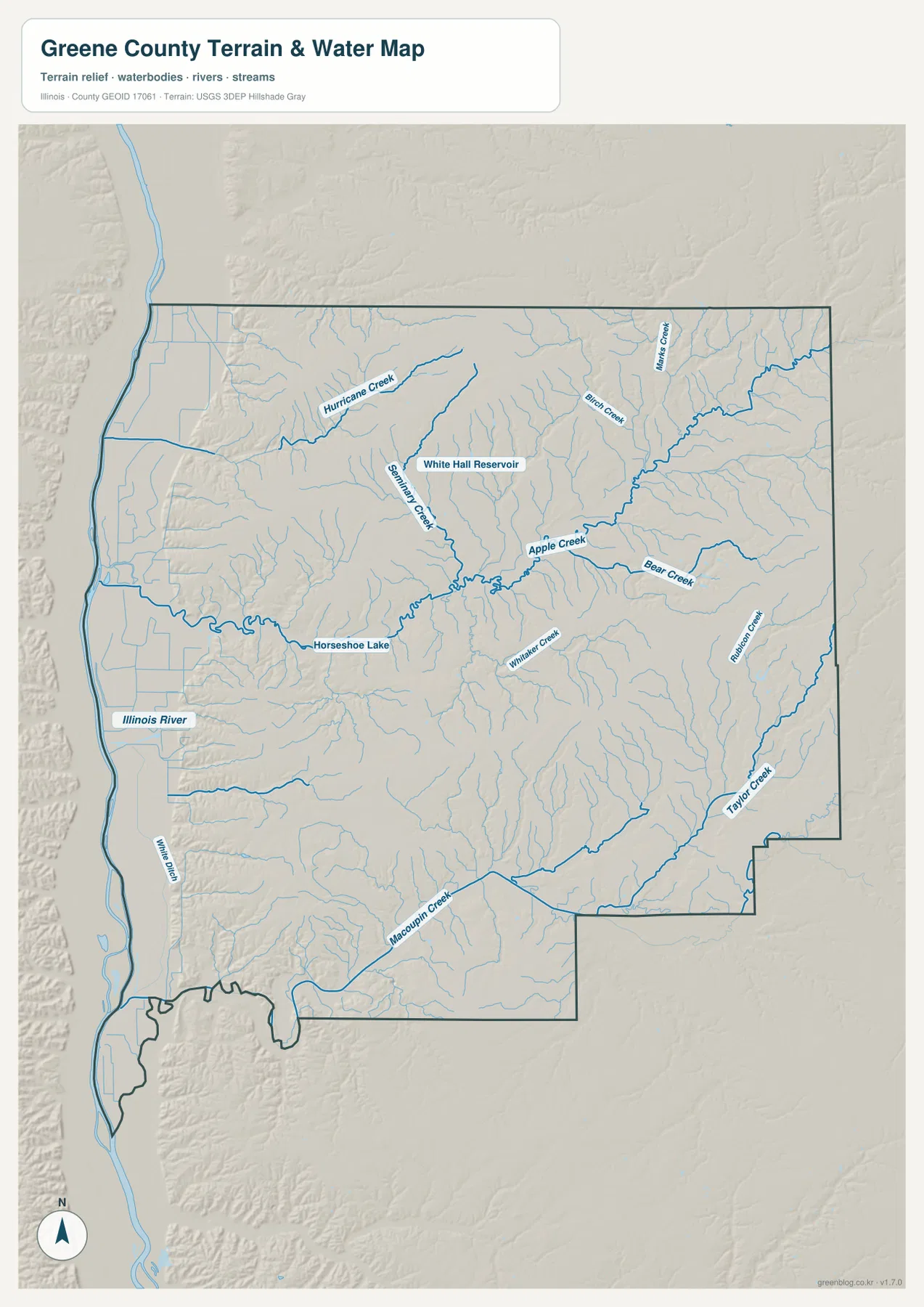
Several smaller features are especially useful for orientation. Horseshoe Lake is labeled in the western interior not far from the Illinois River side, while White Hall Reservoir provides a recognizable point north of the county center. Seminary Creek and Apple Creek help connect the central water network, and a series of eastern tributaries show why the right side of the map contains so many narrow valleys. In the south, Macoupin Creek runs near the county’s lower edge and separates areas of higher ground on the relief shading. These labels make the water map valuable for identifying named streams that are too small to stand out on the general road map.
This map is a geographic reference, not a flood or navigation product. A blue stream line confirms the mapped position of a water feature, but it does not show current discharge, seasonal water level, flood probability, bridge clearance, public access, or safe boating conditions. The low terrain beside the Illinois River likewise should not be interpreted as one uniform flood zone. Anyone making a safety, property, or navigation decision should use current information from the appropriate federal, state, or local agency. For this article, the value of the water view is more straightforward: it shows how Apple Creek and its tributaries divide the interior, where the larger river sits relative to the county boundary, and how reservoirs and lakes fit among the towns and ridges.
The 97–220 meter relief separates river lowland from interior ridges
The elevation map provides the strongest visual contrast in the set. Its legend gives an actual mapped range of about 97 to 220 meters and a mean of 166 meters. The lowest green colors occupy a broad strip along the Illinois River side, continuing into the narrow southwestern projection. Moving east from that lowland, the terrain rises quickly into yellow, tan, and brown ridges. The northern and north-central interior contains some of the most extensive higher ground, while lower green corridors follow Apple Creek and other major valleys through the middle of the county. The result is a landscape of alternating ridges and creek bottoms rather than a smooth slope from one side to the other.
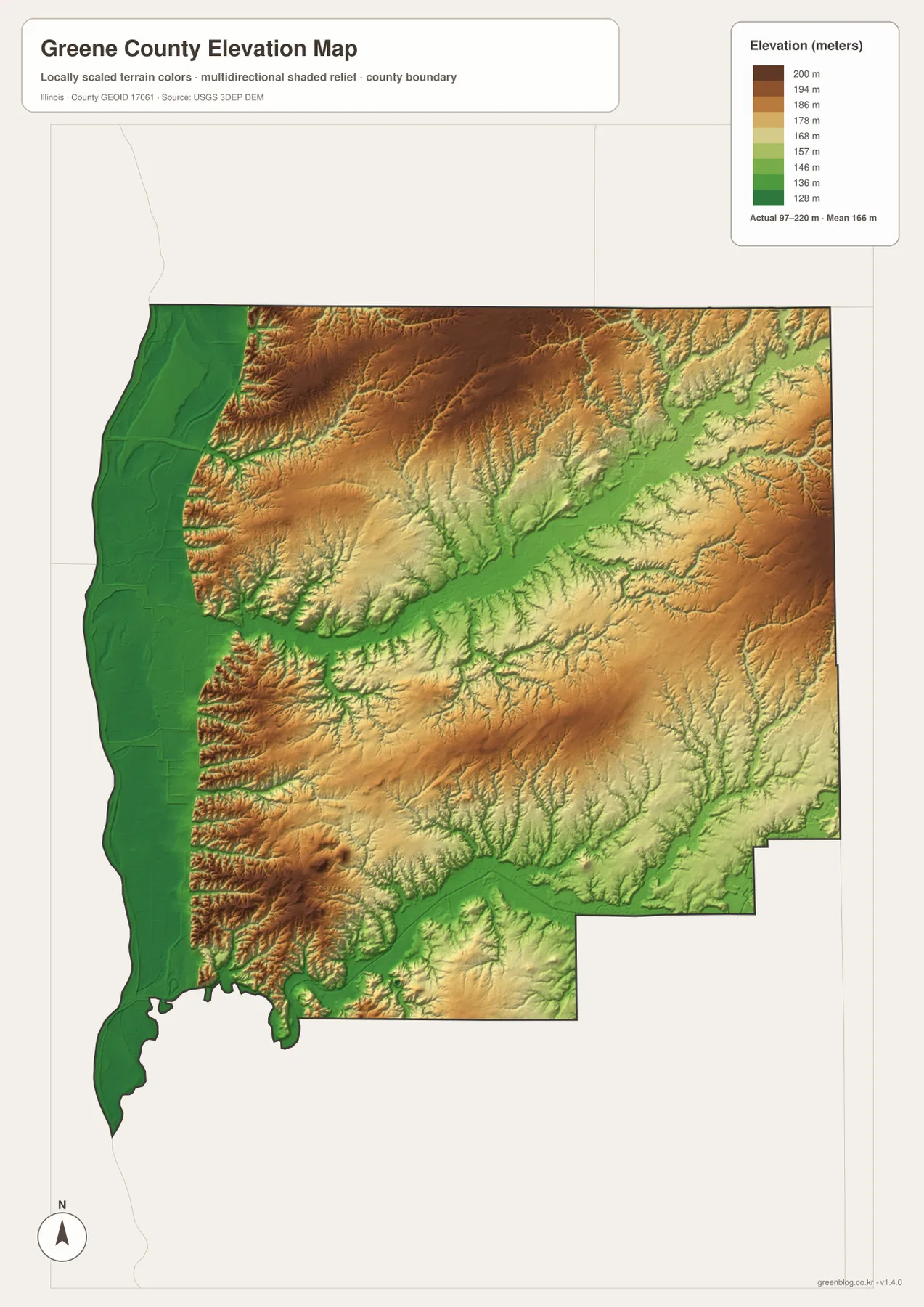
The relationship between water and relief becomes easier to see when this layer is compared with the previous map. Apple Creek follows a lower corridor across the middle, and many narrow tributary valleys branch into the higher terrain on both sides. Hurricane Creek in the northwest also occupies a distinct valley between higher ridges. To the southeast, Taylor Creek and Rubicon Creek correspond with lower green corridors that interrupt the surrounding higher ground. Along the western edge, the difference is broader: the Illinois River lowland creates a wide, continuous zone of low elevation before the surface rises sharply inland.
The colors should be read within the scale printed on this specific Greene County map. A brown area here represents the higher part of a county whose actual maximum is shown as about 220 meters; the same brown tone on another county map may represent a very different absolute elevation if that map uses its own local scale. The layer is also designed for county-scale comparison, not engineering or parcel measurement. It is useful for explaining why the river edge is low and why stream valleys cut deeply into the interior, but it should not be used to assign an exact elevation to a building site, design a road grade, or replace a professional survey. Original USGS 3DEP data are more appropriate when precise elevation analysis is required.
Choose the map according to the feature you need to inspect
For a first look at Greene County, the general county map is the most efficient choice because it combines boundary shape, major communities, nearby places, and numbered roads. It is the view to use when locating Carrollton, following the north-south corridor toward White Hall and Roodhouse, or checking where Greenfield sits relative to Routes 108 and 267. The city index is cleaner when only the six ranked communities matter. It removes many road labels and makes the east-west separation between Eldred and Greenfield especially easy to see.
The water map is better when the question concerns the Illinois River, Apple Creek, Hurricane Creek, White Hall Reservoir, Horseshoe Lake, or the many eastern and southern tributaries. The elevation map is the strongest choice for comparing the river lowland with the higher interior and for seeing how creek valleys cut through those ridges. A useful method is to locate a town on the general map first and then move to the water or elevation view without changing the mental position. Eldred, for example, becomes a clear western lowland reference, while White Hall connects the road pattern with the reservoir and north-central creek system. Carrollton works as a central anchor across all four views.
The browser previews are intentionally reduced for faster page viewing. Small creek labels, route numbers, and the elevation legend are easier to inspect in the downloadable originals, especially when the image is enlarged or printed. The ZIP contains the county reference map, ranked city map, terrain-and-water map, and elevation map as high-resolution JPG files measuring 2572 × 3638 pixels each. They are suitable for classroom reference, presentations, personal research notes, and side-by-side county comparison. They are not intended to replace legal boundary records, current navigation, flood mapping, engineering data, or professional surveying.
Frequently Asked Questions
Why does the western Greene County boundary bend so much more than the eastern side?
The supplied county and water maps show the Illinois River along the western side, where the county line bends repeatedly and narrows into a long southwestern projection. Much of the eastern edge around Greenfield and Rockbridge is straighter. The maps are useful for orientation, but a legally authoritative boundary should be checked against current Census TIGER/Line data or official county records rather than measured from the preview image.
Which community ranks first on the supplied Greene County city index?
Carrollton is ranked first at 2,479 on the supplied index, followed by White Hall at 2,257 and Roodhouse at 1,544. Greenfield is listed at 1,105, Kane at 201, and Eldred at 172. These are the values printed on this map set, not a live population database. Use current Census data if the latest official population figures are needed.
Can the 97–220 meter elevation map be used for surveying or engineering design?
No. The elevation view is meant for county-scale comparison of the low Illinois River margin, higher interior ridges, and lower creek valleys. It does not provide survey-grade spot elevations or engineering tolerances. Site design, drainage work, road grading, or legal surveying should rely on original elevation data, field measurements, and qualified professional work.
Map File Information
The ZIP contains the Greene County road-and-boundary map, ranked city map, terrain-and-water map, and elevation map as original high-resolution JPG files.
- Included Files: 4 JPG maps
- Printable Size: 2572 × 3638 pixels each
- Intended Use: Printing, education, presentations, and geographic reference
Related Maps
Sources and reference data
- Greene County IL Government – About Greene County: official county background, formation date, and Carrollton county-seat reference
- Illinois Department of Transportation – Highway Maps: official Illinois road and map resources
- U.S. Census Bureau – TIGER/Line Shapefiles: county boundary and geographic reference data
- USGS National Hydrography: national waterway and hydrography reference data
- USGS 3D Elevation Program: elevation and terrain source data
Green Map creates custom-edited map images using open geographic data sources such as geoBoundaries, Natural Earth, OpenStreetMap, and government open data.
These maps are edited visual materials, not raw data files, and are provided for education, documents, presentations, and graphic reference.