Franklin County in southern Illinois is easy to orient from Benton, West Frankfort, Rend Lake, and the I-57 corridor. You can download the high-resolution JPG map files directly from this page as one ZIP archive, while the WebP maps below provide quick browser previews of county roads and boundaries, selected communities, named water features, and elevation. Route 14 crosses the Benton area, other numbered highways spread toward Sesser, Christopher, Zeigler, Royalton, Ewing, and Thompsonville, and the Big Muddy River system links the large reservoir in the north with lower terrain farther south. The article uses those mapped features to explain how the county fits together before you choose the file that best matches your purpose.
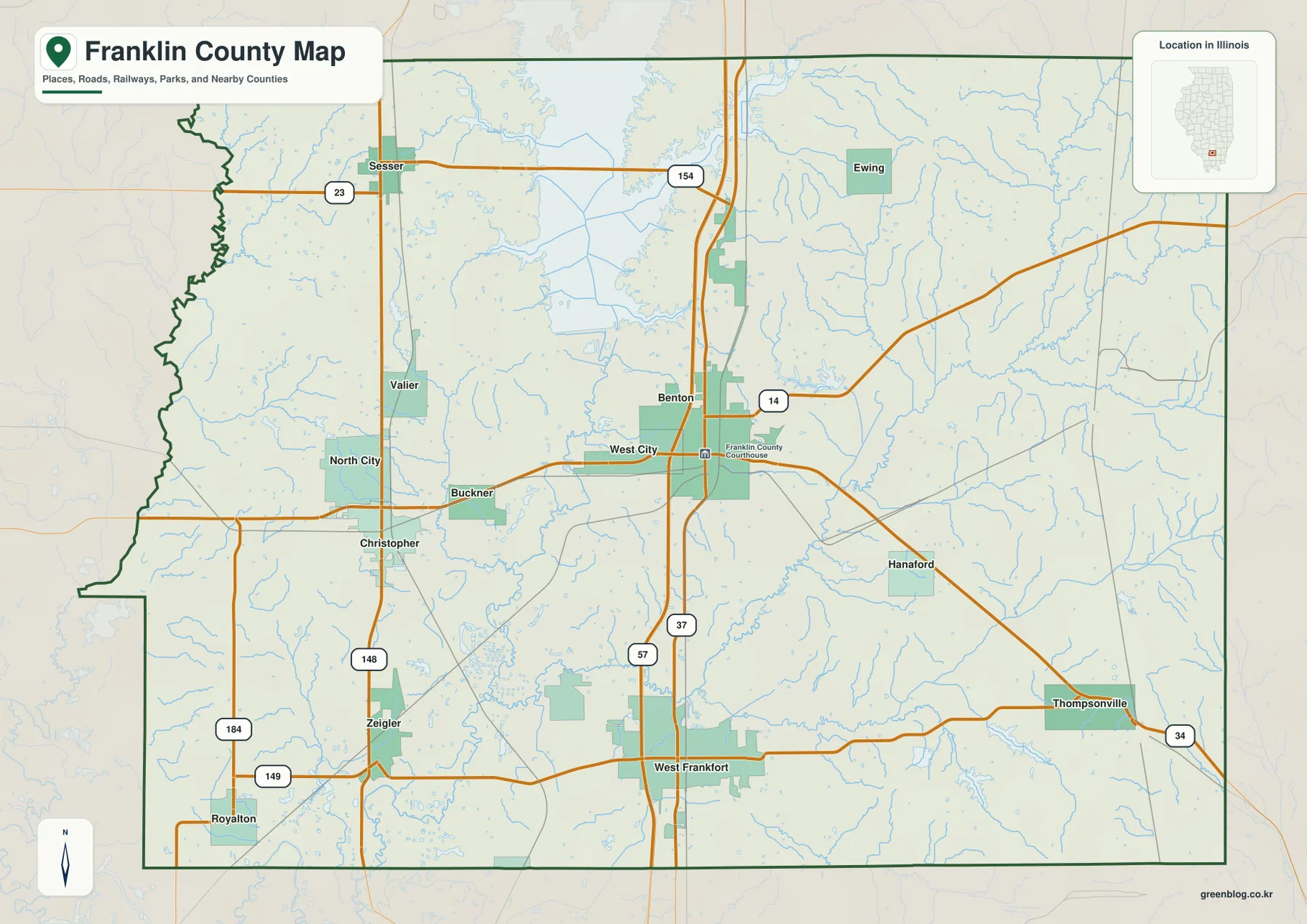
Benton is the county seat, and the Franklin County Courthouse is marked directly on the general map. The county government’s own website identifies Benton as the seat of county government and describes I-57 as a major access route through Franklin County. West Frankfort lies farther south on the same broad transportation corridor, while Christopher and Buckner sit west of Benton and Sesser anchors the northwest. Ewing, Hanaford, and Thompsonville help orient the eastern half of the county. Seeing these places together makes the map more useful than a simple city list because it shows how several small communities are spread across a county that is not dominated by one continuous urban area.
The natural features are equally important. Rend Lake extends across the northern edge, with its southern arms reaching into the county near Benton. The terrain-and-water view traces the Big Muddy River and Middle Fork Big Muddy River as well as smaller creeks, reservoirs, and ponds. The elevation map reports an actual range of roughly 109 to 184 meters and a mean near 132 meters. Lower green terrain is broad through the central county, while higher brown and tan ridges become much more noticeable along the east and northeast, with additional uplands near the western edge. Reading the four supplied views together gives a clear picture of how roads, communities, water, and relief fit into the same landscape.
Table of Contents
Benton and West Frankfort Define the Main North-South Road Corridor
The general county map is the best starting point because it combines the boundary, selected communities, parks, roads, rail lines, and many small water features. I-57 forms the clearest north-south route through the Benton–West Frankfort corridor, and Route 37 provides another strong vertical reference in the same part of the county. Route 14 runs east-west through Benton and continues toward West City, Buckner, and the western side. Farther south, Routes 149 and 184 help locate Royalton and Zeigler, while Route 34 reaches the Thompsonville side of the county. In the northwest, Routes 23 and 154 make Sesser easy to find.
The town pattern becomes more useful when read against the boundary. Sesser lies near the northwest, Valier and North City sit farther south, and Christopher provides a western reference roughly across from the Benton area. Zeigler and Royalton occupy the southwest, while Ewing lies northeast of Benton. Hanaford and Thompsonville extend the mapped settlement pattern into the east and southeast. This spread means that a visitor looking only at Benton would miss much of the county’s geography. The western communities sit closer to Perry, Jackson, and Williamson County directions, while eastern places face Hamilton and Saline County.
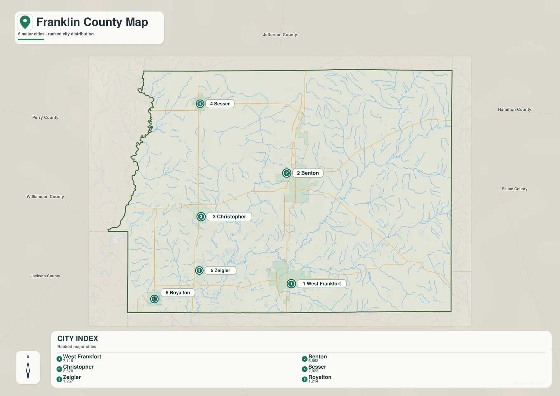
The neighboring-county labels on the city map add another layer of orientation. Jefferson County is north of Franklin County, Hamilton and Saline counties are to the east, Williamson and Jackson counties lie to the southwest, and Perry County is to the west. Those labels make it easier to understand why Sesser, Thompsonville, and Royalton relate to different edges of the county. They also help when comparing Franklin County with adjacent map pages. The supplied map remains a reference graphic rather than a turn-by-turn navigation product, so current route closures, legal boundary questions, and detailed travel planning should be checked with current state or local transportation information.
A Six-Place City Index Led by West Frankfort and Benton
The city map strips away many secondary labels and concentrates on six ranked places. In the supplied index, West Frankfort appears first at 7,118 and Benton second at 6,863. Christopher follows at 2,570, Sesser at 2,223, Zeigler at 1,267, and Royalton at 1,214. These values should be treated as the index printed on the supplied map rather than as a newly verified current population table. Their practical value is comparative: they show which six places were selected as the strongest settlement references and how widely those places are distributed across the county.
West Frankfort and Benton are relatively close to the county’s central north-south corridor, but the remaining places pull the settlement pattern toward the west. Christopher lies west of Benton, Zeigler and Royalton extend the group into the southwest, and Sesser stands well to the northwest near the Rend Lake side of the county. The arrangement is therefore not a single straight chain. Instead, it forms a broad set of local centers around the central road corridor. This is useful in presentations or classroom work because it prevents the county from being represented as though all activity were concentrated in Benton alone.
U.S. Census Bureau QuickFacts reports 37,804 residents in Franklin County at the 2020 Census and about 408.92 square miles of land area. Those countywide figures provide useful scale for the city map. The mapped communities are spread through a fairly large area, and several significant places do not appear in the six-place ranking at all. For that reason, this city layer works best as a simplified comparison of selected settlements. Use the general map when the goal is to locate smaller communities such as Valier, North City, Ewing, Hanaford, or Thompsonville in relation to highways and the county boundary.
Rend Lake and the Big Muddy River Organize the Water Map
Rend Lake is the dominant water feature in the northern part of the terrain-and-water map. Illinois Department of Natural Resources material describes the reservoir as lying in Franklin and Jefferson counties and as having been created by damming the Big Muddy River. That relationship is easy to see on the supplied map: the lake spreads across the north while a bold Big Muddy River channel continues southward through the county. Benton lies south of the reservoir, and Sesser is positioned to its west, so the water map immediately provides geographic context for two important communities shown on the road layer.
Several smaller named water bodies add local detail. Sesser Lake and Valier Mine Pond are labeled in the northwest, Lake Benton appears southeast of Rend Lake, and Lake Moses lies farther east. Near West Frankfort, the map labels both West Frankfort City Lake and West Frankfort Reservoir. These features help distinguish parts of the county that can otherwise look similar on a road map. The many unnamed blue branches also matter because they show how densely small drainage lines cut through the surrounding countryside.
The named streams give the map a clear east-west structure. Middle Fork Big Muddy River approaches from the east and bends toward the main Big Muddy system. Sugar Camp Creek is labeled in the northeast, while Ewing Creek crosses the southeast. Andy Creek appears west of the central river system, and Green River is marked farther south. Together, these waterways show that the Big Muddy is not an isolated channel. It receives or connects with a wide network of smaller streams that cross the lower parts of Franklin County between ridges and uplands.
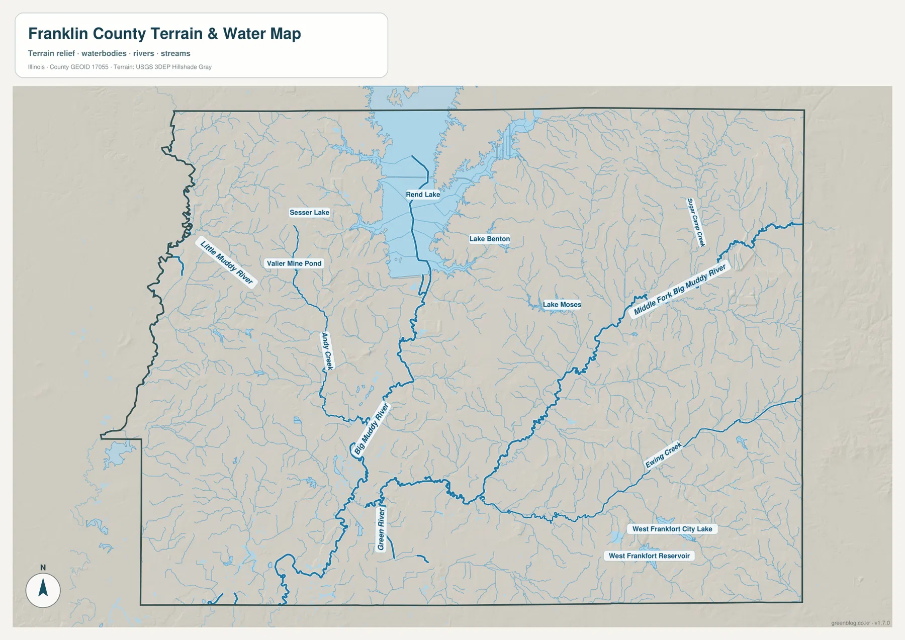
This map should not be used as a flood-risk, depth, water-quality, navigation, fishing-regulation, or property-access product. Reservoir levels can change, small streams may behave differently after heavy rain, and access rules depend on the managing agency and location. Its strength is geographic reference: it helps a reader understand where the main lakes and channels sit relative to Benton, Sesser, West Frankfort, and the county boundary. Anyone making a safety, boating, or land-use decision should consult current USGS, Illinois, or site-specific information.
Central Lowlands Contrast with Higher Ridges on the East Side
The elevation map reports an actual county range of about 109 to 184 meters, with a mean near 132 meters. Franklin County does not contain a dramatic mountain range, but the shaded surface reveals substantial local contrast. Dark and medium greens dominate a broad central area from the Rend Lake side through the Benton–West Frankfort corridor, indicating relatively low ground. Tan and brown tones become more frequent toward the eastern and northeastern edges, where narrow ridges and dissected hills create a rougher appearance.
The southeast also shows stronger relief than the middle of the county. Around the Thompsonville side and the eastern boundary, higher ridges stand beside lower creek valleys in short distances. The west is not uniformly flat either. Upland bands appear near the Perry County side west of Sesser and Christopher, broken by lower drainage corridors. These contrasts explain why the water layer contains so many branches: small streams occupy the lower cuts between ridges, while the central Big Muddy system follows a broader low area.
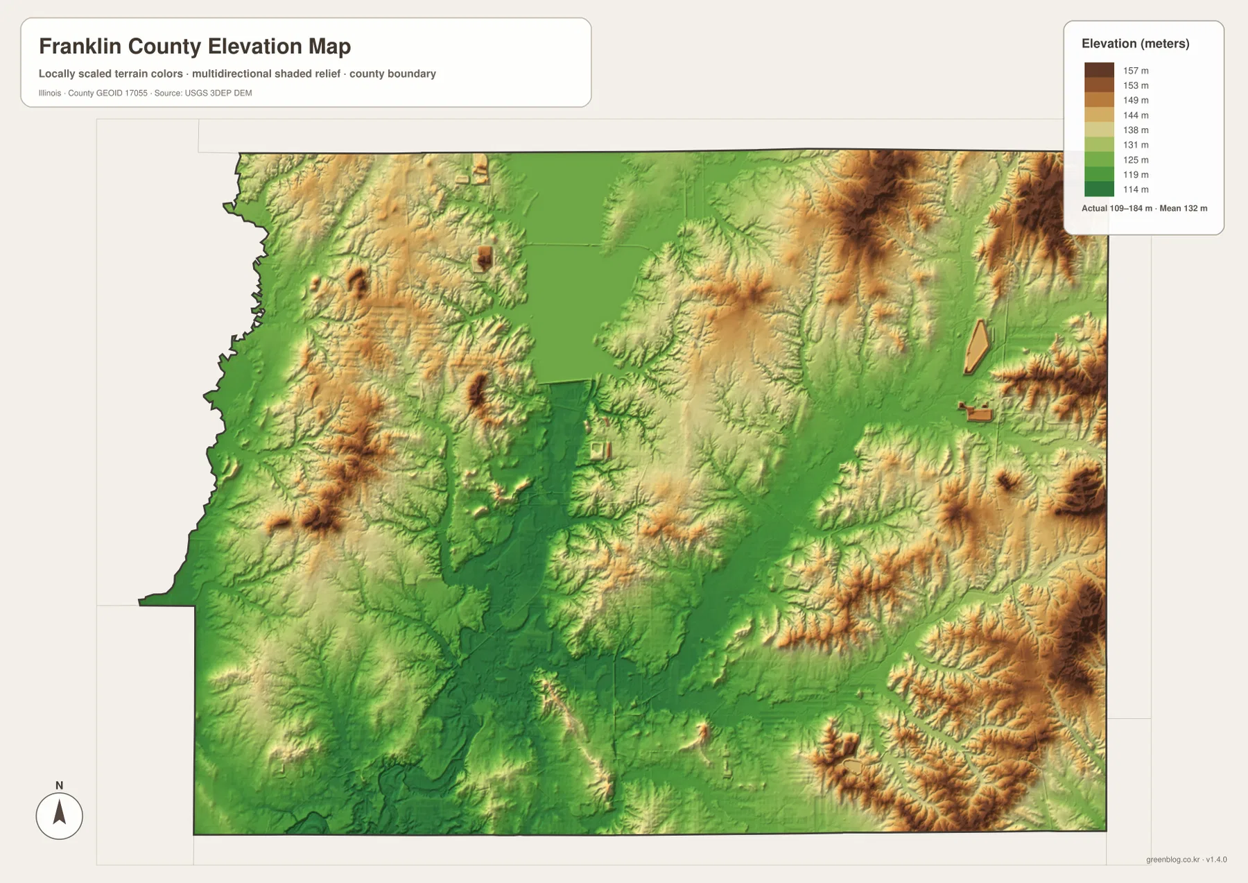
Comparing the elevation map with the water map is especially useful around Rend Lake and the Big Muddy River. The lake’s southern outlet and much of the main river corridor correspond with lower green terrain, while tributaries such as Middle Fork Big Muddy River and Ewing Creek pass through valleys between higher ridges. That visual relationship is appropriate for county-scale interpretation, but the elevation layer is not survey-grade or engineering-grade data. Exact site elevations, drainage design, construction planning, and legal measurements require original USGS 3DEP data and professional field information.
Choosing the Right View for Benton, Rend Lake, or West Frankfort
A practical way to use the set is to begin with the question rather than the map type. For county orientation, find Benton and West Frankfort on the general map, then use I-57 and Route 37 as north-south references. Route 14 helps connect Benton with West City, Buckner, and the Christopher direction. If the task is to compare the selected settlement centers, switch to the city map and note how Sesser, Christopher, Zeigler, and Royalton spread westward from the central corridor.
For natural geography, start with Rend Lake and follow the Big Muddy River south. Then look east for Middle Fork Big Muddy River, Sugar Camp Creek, and Ewing Creek. The elevation map can be used immediately afterward to compare the lower central river corridor with the more elevated ridges near the eastern boundary. Around West Frankfort, the water layer adds City Lake and the reservoir, while the elevation layer shows the surrounding changes in relief. Repeating the same location across two or three views is more informative than treating each image as an isolated diagram.
The WebP images embedded in the page are intended for quick browser viewing. Small creek labels, route numbers, and fine terrain details are easier to read in the original files. The ZIP contains the county, city, water, and elevation maps as 3638 × 2572 pixel high-resolution JPG images. They are suitable for enlargement, personal reference, classroom handouts, and presentation graphics. When printing, keep the original aspect ratio and check a proof copy first if small labels need to remain readable at the chosen paper size.
Frequently Asked Questions
How are Rend Lake and the Big Muddy River related on the map?
Rend Lake is the large water body across the northern part of the water map, and the Big Muddy River continues south from the lake area through Franklin County. Illinois Department of Natural Resources information describes Rend Lake as a reservoir on the Big Muddy River that extends through Franklin and Jefferson counties. Use the water map for the lake-and-river relationship and the general map when you also need Benton, Sesser, and road positions.
Which map is best for comparing Benton and West Frankfort?
The general county map is the most useful choice when roads and the courthouse location matter. Benton is north of West Frankfort along the main central corridor, and the Franklin County Courthouse is labeled in Benton. The city map is cleaner if you only want the relative placement of the six ranked settlements and their supplied index values.
Can the 109–184 meter elevation range be used for surveying or construction?
No. The elevation surface is designed for county-scale comparison of lower central terrain and higher ridges on the east and west sides. It does not establish the exact elevation of a parcel, road, or building site. Surveying, engineering, drainage design, and construction work should use original USGS 3DEP data and professional site measurements.
Map File Information
The ZIP contains the Franklin County boundary-and-road, city, water, and elevation maps as original high-resolution JPG files.
- Included Files: County, city, water, and elevation maps
- Printable Size: 3638 × 2572 pixels each
- File Type: High-resolution JPG files in one ZIP archive
Related Maps
Sources and Reference Data
- Franklin County, Illinois – Our County – official county overview with southern Illinois, Rend Lake, I-57, and Benton context
- Illinois Department of Natural Resources – Rend Lake Description – official reference for Rend Lake, the Big Muddy River, and the Franklin–Jefferson county setting
- U.S. Census Bureau QuickFacts – Franklin County, Illinois – county population and land-area reference
- Illinois Department of Transportation Highway Maps – official Illinois highway and road-map resources
- USGS National Hydrography – river, stream, and water-feature reference
- USGS 3D Elevation Program – elevation and terrain reference
Green Map creates custom-edited map images using open geographic data sources such as geoBoundaries, Natural Earth, OpenStreetMap, and government open data.
These maps are edited visual materials, not raw data files, and are provided for education, documents, presentations, and graphic reference.