Washington County in western Idaho is easiest to understand by following the line of towns from Weiser toward Midvale and Cambridge. Weiser sits near the southwest edge of the county, Midvale lies farther northeast, and Cambridge is farther north. Away from those towns, the maps become increasingly dominated by branching streams, narrow valleys, and higher ridges, especially across the northern and western parts of the county.
This Washington County Idaho Map page brings those features together in a county overview, a simplified city-connections map, a terrain-and-water map, and an elevation map. You can download high-resolution JPG versions of all four maps in one ZIP file, so the same maps shown on the page are ready for printing, classroom work, presentations, or closer viewing.
The official Washington County website places county offices in Weiser, while its visitor information describes Cambridge as a rural community on U.S. Highway 95 and a gateway toward Hells Canyon. The supplied maps complement that local context by showing how Weiser, Midvale, and Cambridge sit within a county crossed by the Weiser River system and surrounded by terrain that rises sharply away from the lower southern areas.
Table of Contents
Weiser, Midvale, and Cambridge set the main reference points
The county overview gives Weiser the clearest starting point because it sits close to the southwest corner of the boundary. Payette and Fruitland appear just south of the county, providing useful outside references. From Weiser, the main mapped route heads northeast toward Midvale and then continues toward Cambridge, so the three towns form a simple sequence that is easy to recognize even on a full-county map.
Cambridge occupies a more northerly position where several mapped roads meet or diverge. Council appears outside the county to the east, while the western and northern edges of Washington County contain far fewer labeled towns. Instead, those areas show many small watercourses and more complicated terrain. The contrast helps explain why the town names are concentrated along one broad corridor while the rest of the county looks much more rural and mountainous.
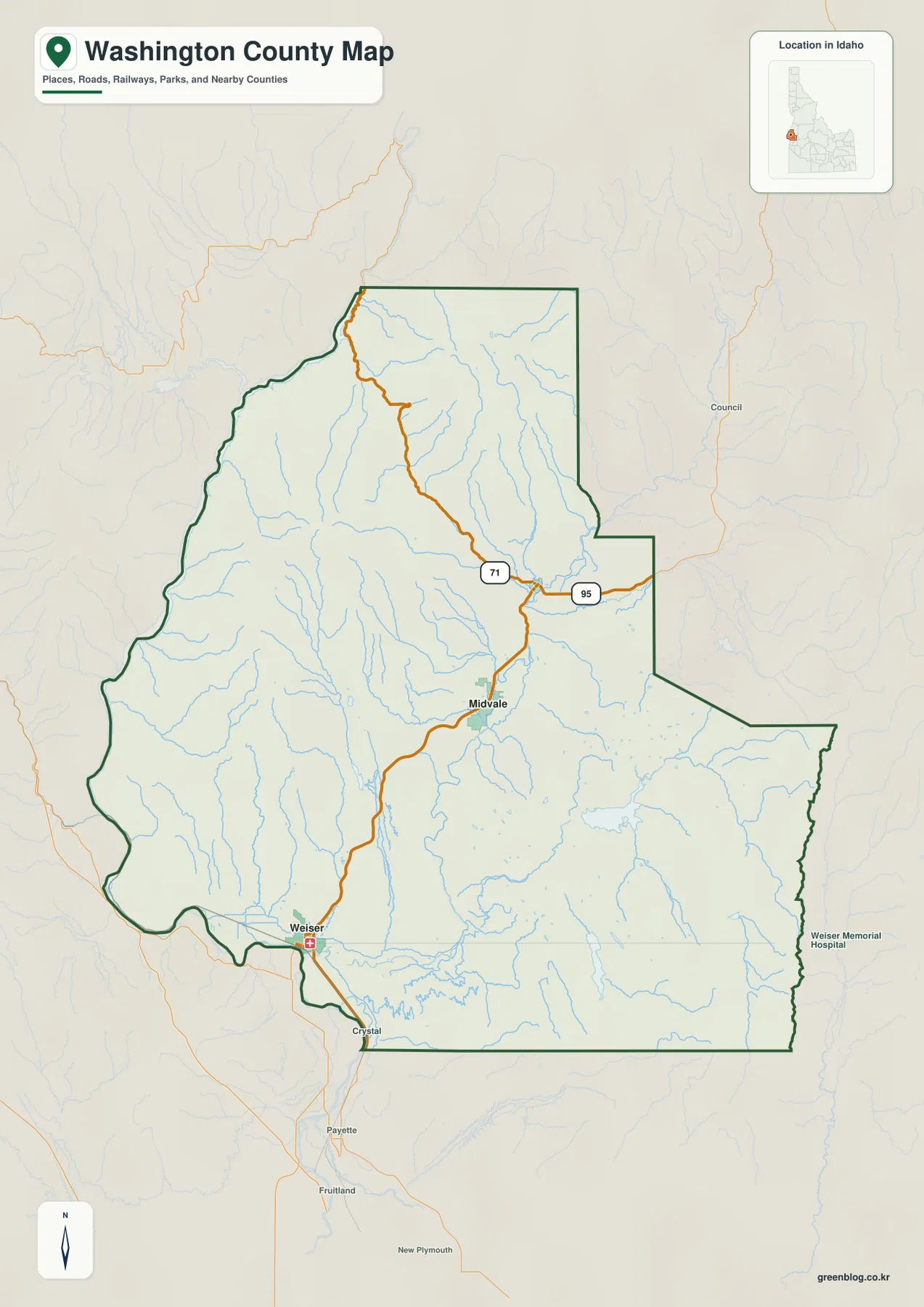
The county outline itself also changes character from side to side. Parts of the western boundary bend around valleys and terrain, while several eastern and southern stretches are much straighter. That shape is useful when matching the county map with the water and elevation maps, because the same irregular western edge and stepped eastern side make it easier to compare locations across all four images.
Use Weiser as the southwestern anchor
If Washington County is unfamiliar, start with Weiser and then look northeast for Midvale and northward for Cambridge. That sequence provides a practical frame for the rest of the map. Once those towns are located, the rivers, reservoirs, and higher northern terrain can be added without losing track of direction. The overview is meant for county-scale orientation rather than turn-by-turn navigation.
Road closures, seasonal access, construction, and private-property boundaries are not shown with the precision needed for travel or legal decisions. The county boundary is also not a parcel map. Use the overview for geographic context, then consult current road, assessor, or land-management information when a decision depends on up-to-date conditions or exact ownership lines.
Straight-line distances from Weiser
The city-connections map removes much of the background detail and emphasizes three places. Weiser is marked as the hub, Midvale is labeled at about 18 miles from Weiser, and Cambridge is labeled at about 26 miles. Those figures are direct or straight-line distances between the mapped points. They are not road mileage and should not be used to estimate driving time.
The simplified map is especially useful for direction. Midvale lies northeast of Weiser, while Cambridge is farther north and slightly east. Neighboring counties are labeled around the map as additional orientation points: Payette County to the west, Adams County to the north, and Gem and Boise counties to the east. Together, those labels make it easier to place Washington County within western Idaho without adding a large amount of street-level detail.
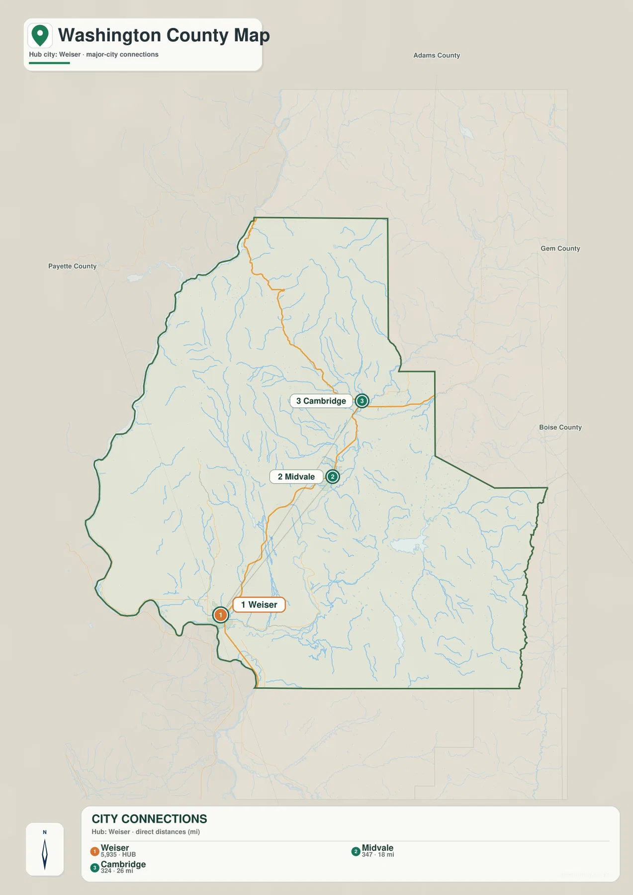
For a classroom slide, local introduction, or quick comparison of town positions, this map is often clearer than the detailed county overview. It answers a limited question well: where are the main mapped towns in relation to Weiser? For actual travel, the detailed road network and current navigation data matter much more than the straight-line values shown here.
Why direct distance and driving distance differ
Washington County contains rivers, creeks, valleys, and substantial elevation changes, so a road rarely follows the exact straight line between two towns. A route may curve around terrain or cross a river at a limited number of locations. The 18- and 26-mile figures are therefore best used to compare relative spacing, not to calculate fuel use, travel time, or the length of a road trip.
Weiser River, creeks, and reservoirs across the county
The terrain-and-water map changes the emphasis from towns to drainage features. The Weiser River is labeled through the central and southern part of the county, and the Little Weiser River appears farther east and northeast. Crooked River is labeled in the north, Crane Creek crosses the central area, and Mann Creek is prominent in the west. Numerous smaller tributaries branch through the shaded terrain between them.
Several reservoirs provide additional landmarks. Mann Creek Reservoir appears in the southwest-central part of the county, while Crane Creek Reservoir is farther east. Soulen Reservoir and Paddock Valley Reservoir are labeled in the southern half. Because the streams and reservoirs are shown together, the map is useful for seeing where named water features sit relative to the county boundary and to the surrounding ridges and valleys.
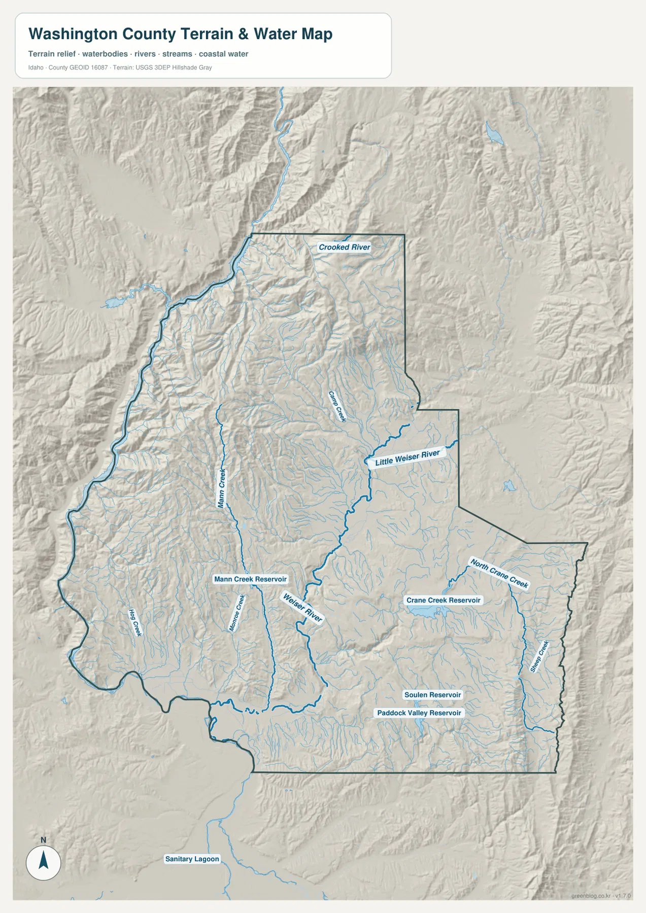
Shaded relief makes the northern and western terrain particularly noticeable. Narrow valleys and ridges repeat across those areas, and many streams curve through the lower ground between them. The southeastern part of the county looks broader and less rugged by comparison, although it still contains numerous small watercourses. Looking at the water map beside the county overview helps connect the apparent gaps between towns with the physical landscape that occupies them.
What the water map does not show
This is a reference map for the location of rivers, creeks, reservoirs, and terrain. It is not a flood-hazard map, a live stream-gauge display, a depth chart, a navigation chart, or a water-rights map. Anyone making a safety, boating, legal, or water-management decision should use current information from USGS and the appropriate state or local agency.
Elevation rises from lower southern ground to high ridges
The elevation map gives the clearest picture of Washington County’s relief. Large areas in the south and center are shown in green, indicating lower terrain relative to the rest of the county. Yellow, orange, and brown become more common toward the north and northeast, while high ridges also run through parts of the west. The result is a county where lower river valleys and uplands sit close to much steeper mountain terrain.
The map prints an actual countywide elevation range of about 550 to 2,396 meters and a mean of about 1,128 meters. Those numbers summarize the complete elevation surface represented in the map. They do not mean that Weiser is exactly 550 meters high or that Cambridge is 2,396 meters high, and they should not be assigned to a particular road, reservoir, parcel, or building site.
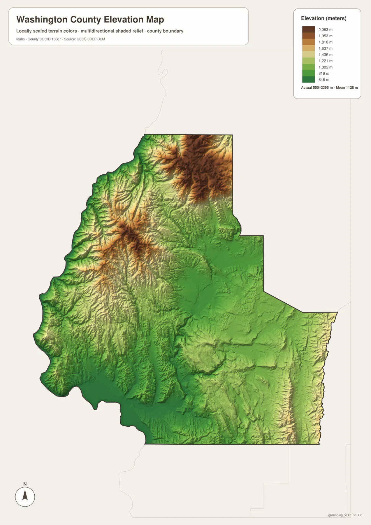
Comparing the elevation map with the water map is particularly useful. Streams such as Mann Creek and Crooked River occupy valleys cut between ridges, while the Weiser River system crosses lower terrain farther south. The relationship is visible at county scale without requiring technical terrain analysis: higher colors surround narrow lower corridors, and many of the mapped waterways follow those corridors.
550 to 2,396 meters is a countywide range
The elevation image is designed for broad comparison, not engineering measurement. A reader can use it to distinguish lower valleys from higher ridges and to understand why the county’s terrain changes so much from south to north. Exact elevations for a city, road crossing, structure, or parcel should come from source DEM data, a surveyed benchmark, or another location-specific dataset.
Choosing the right Washington County map
Use the county overview when the goal is to see boundaries, towns, roads, nearby places, and streams together. Choose the city-connections map when a simple Weiser–Midvale–Cambridge comparison is more important than road detail. The water-and-terrain map is the better choice for named rivers, creeks, reservoirs, and relief, while the elevation map makes the lower southern areas and higher northern or western terrain easiest to compare.
A practical way to combine the maps is to locate Weiser, Midvale, and Cambridge on the overview first. Next, use the city map to compare the direct 18- and 26-mile distances from Weiser. Then move to the water map to find the Weiser River, Little Weiser River, Mann Creek, and the named reservoirs. Finish with the elevation map to see how those same places fit within a county that spans more than 1,800 meters from its lowest to highest mapped terrain.
Each map also has limits. The overview is not a legal parcel map or live road-status service, the city map does not provide driving mileage, the water map should not be used for flood or navigation decisions, and the elevation map is not survey-grade. Used within those limits, the set works well for education, presentations, printed reference sheets, trip orientation, and general county geography.
Frequently Asked Questions
Are the 18- and 26-mile labels driving distances?
No. On the supplied city-connections map, Midvale is about 18 miles from Weiser and Cambridge is about 26 miles from Weiser by direct straight-line distance. Actual road mileage and travel time can differ because roads follow terrain, river crossings, and available routes.
Does 550 to 2,396 meters give the elevation of Weiser or Cambridge?
No. That is the actual range printed for the countywide elevation dataset shown on the map. It summarizes the lowest and highest mapped terrain somewhere within Washington County. Exact elevations for individual towns, roads, reservoirs, or properties require location-specific elevation or survey data.
Can the water map be used for flood or boating decisions?
No. It is a geographic reference showing the locations of rivers, creeks, reservoirs, and terrain. It does not provide flood zones, live water levels, depths, navigation conditions, water rights, or legal access information. Use current agency data for any safety or regulatory decision.
Sources and Reference Material
The article uses the supplied Washington County maps together with the official references below. For legal boundaries, current road conditions, live water information, or exact point elevations, rely on the responsible agency’s current source data rather than these explanatory county maps.
- Washington County, Idaho Official Website – county government and local information
- Washington County Visitor Information – local visitor context, including Cambridge
- U.S. Census Bureau TIGER/Line Shapefiles – county boundaries and geographic reference data
- USGS National Hydrography – rivers, streams, lakes, and reservoir reference data
- USGS 3D Elevation Program – elevation and terrain data
Map File Information
The high-resolution JPG originals for the Washington County overview, city-connections map, terrain-and-water map, and elevation map are bundled in one ZIP file. Each image is 2,572 × 3,638 pixels, giving you more detail for zooming, printed reference sheets, classroom displays, or presentation graphics.
- Included Files: 4 high-resolution JPG maps
- Printable Size: 2,572 × 3,638 pixels each
Related Maps
Green Map creates custom-edited map images using open geographic data sources such as geoBoundaries, Natural Earth, OpenStreetMap, and government open data.
These maps are edited visual materials, not raw data files, and are provided for education, documents, presentations, and graphic reference.