Valley County stretches from the McCall–Donnelly–Cascade corridor on its western side into a much larger mountain interior filled with headwater streams, lakes, reservoirs, and high ridges. The general map makes that contrast immediately visible. Idaho 55 runs north and south along the western valley, where most of the labeled communities are concentrated, while Yellow Pine and the eastern part of the county sit far from that main corridor in a landscape with fewer roads and far more drainage lines.
This Valley County Idaho Map page includes a general county map for roads, places, and the boundary; a simplified city-connections map centered on McCall; a terrain-and-water map for the Payette and Salmon river systems; and an elevation map for comparing the lower western valley with the high mountain country. High-resolution JPG originals of all four maps are also packaged in one downloadable ZIP, so the same maps can be used on a large screen or printed at A3 size.
Valley County’s own history page adds useful context to the pattern visible on the maps. It says the railroad reached McCall in 1914 and helped Cascade, Donnelly, and McCall become the county’s main population centers. The county was created in 1917, and the completion of Cascade Dam on the Payette River in 1948 formed the reservoir later known as Lake Cascade. Those historical notes match the modern geography shown here: a populated western valley beside a vast mountainous interior crossed by several major headwater systems.
Table of Contents
McCall, Donnelly, and Cascade line up along the western valley
The easiest feature to use for orientation is Idaho 55. It enters the county from the south near Smiths Ferry, continues north through Cascade and Donnelly, and reaches the McCall area in the northwest. Despite the county’s large east-west extent, its most prominent labeled communities occupy this relatively narrow western strip. That makes the highway and the long valley around it a practical reference line for reading the rest of the map.
McCall sits near the northwestern side of the county, Donnelly is farther south, and Cascade is farther south again. Nearby water bodies and tributaries crowd the same part of the map, while places outside the county such as New Meadows and Council help show how the western edge relates to surrounding Idaho. The county’s outline then expands dramatically eastward, where the road network becomes thinner and the map is dominated by mountain drainage.
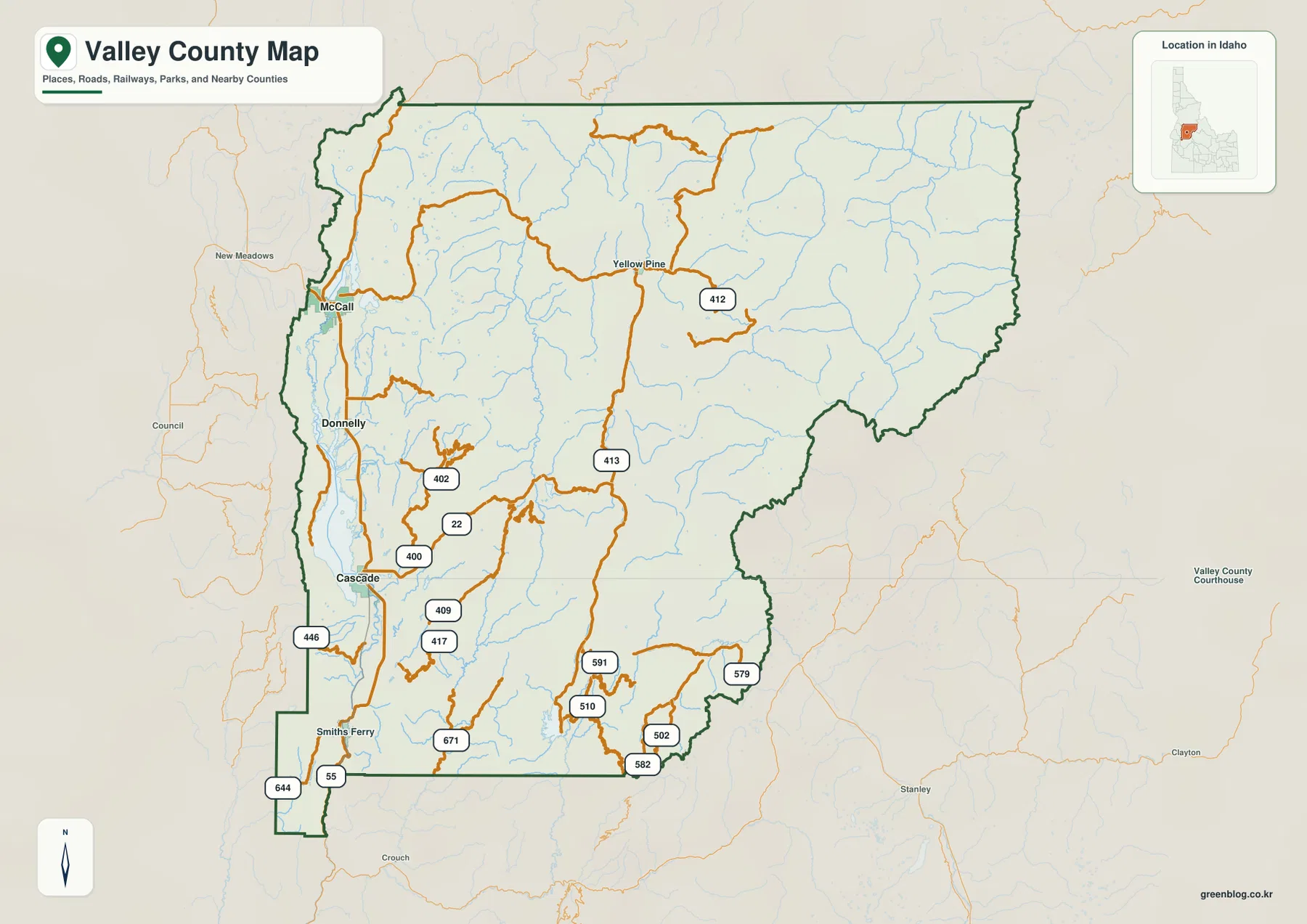
Yellow Pine provides a useful contrast. It appears well inside the mountainous northern interior rather than on the Idaho 55 corridor. Roads near it bend through narrow valleys instead of following the broad north-south alignment visible in the west. Much of the eastern half has many streams but few settlement labels, so the map should not be read as empty country. It is a large mountain landscape in which drainage and relief are more visually important than towns.
Use Idaho 55 as the main orientation line
If Valley County is unfamiliar, start by finding McCall, Donnelly, and Cascade on Idaho 55. Once those places are fixed in mind, the remainder of the county is easier to organize: Smiths Ferry lies farther south on the same general corridor, while Yellow Pine and the Salmon River headwaters lie deep to the east and northeast. This simple reference line prevents the irregular county outline and numerous mountain roads from becoming confusing.
The general map is not a live navigation service. Seasonal conditions, closures, construction, and mountain weather can change access on roads that look continuous at county scale. Use it to understand the relationship among places, roads, and the county boundary, then consult current transportation or land-management information when planning an actual drive into the interior.
McCall as a hub: Donnelly 12 miles, Cascade 27 miles
The city-connections map removes most of the geographic detail and highlights only McCall, Donnelly, and Cascade. McCall is identified as the hub. Donnelly is shown about 12 miles away and Cascade about 27 miles away. These are direct, straight-line distances used by the map, not driving distances along Idaho 55, so they should be treated as a simple way to compare relative spacing rather than as a road-trip calculation.
The more useful message is the north-south order. Donnelly lies south of McCall, and Cascade lies farther south again. All three are on the western side of the county, leaving most of the large eastern interior outside this simplified city view. When the city map is compared with the general map, the reason for the west-side concentration becomes clearer: the three towns share the long valley corridor that also carries the county’s most obvious north-south road.
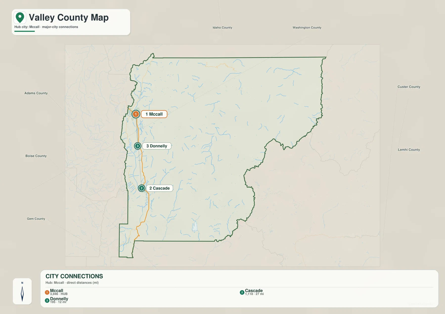
This reduced view works well when a reader only needs to remember where the main west-side communities sit. McCall anchors the north, Donnelly occupies the middle, and Cascade is farther south. Because the mountain interior has been visually simplified, the map also emphasizes how small the main settlement corridor is compared with the county as a whole.
Straight-line distance is not road distance
That distinction matters in a county of mountains, water bodies, and winding valleys. A straight line measures the separation between city locations without following the road. The actual route may curve around terrain or water and can therefore be longer. Use the 12- and 27-mile labels to understand relative spacing, but use current road information for travel distance and time.
Seen together, the city and general maps answer different questions. The city view makes the settlement pattern memorable; the general map shows how the same places relate to Idaho 55, nearby streams, county roads, and the much larger mountain area to the east.
Payette waters in the west, Salmon headwaters across the mountain interior
The terrain-and-water map changes the emphasis from settlements to drainage. North Fork Payette River and Middle Fork Payette River appear in the western and southern parts of the county, with Upper Payette Lake and Box Lake in the northwest. Farther into the mountains, Deadwood River and Deadwood Reservoir form another clear reference area. To the north and east, branches of the South Fork Salmon River and the Middle Fork Salmon River cross a much more rugged landscape.
This is one of the most distinctive features of Valley County. The west-side communities are associated visually with the Payette system, but the county extends far beyond that valley into Salmon River headwaters. The eastern two-thirds of the general map can seem lightly settled, yet the water map reveals a dense network of valleys and streams. What looks empty on a road-and-place map is actually heavily structured by mountain drainage.
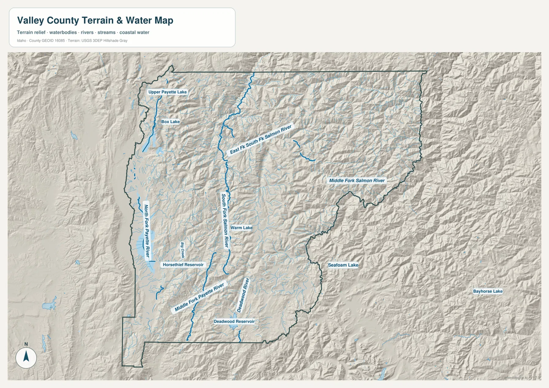
Warm Lake and Deadwood Reservoir are especially useful landmarks in the central part of the county. Warm Lake helps locate the South Fork Salmon River area, while Deadwood Reservoir marks the Deadwood River valley farther south. The Middle Fork Salmon River appears along the eastern side, emphasizing how far the county reaches from the McCall–Cascade corridor into central Idaho’s rugged headwater country.
Lake Cascade and high-mountain water bodies belong to very different settings
Valley County’s official history says Cascade Dam was completed on the Payette River in 1948 and that the resulting reservoir was later renamed Lake Cascade. That broad west-side water body is part of the inhabited valley around Cascade and Donnelly. In contrast, Upper Payette Lake, Box Lake, Warm Lake, and Deadwood Reservoir sit in more mountainous settings. Comparing them on one map shows how varied the county’s water geography is.
This map is a geographic reference, not a flood, navigation, water-right, or access product. It does not provide current streamflow, water level, depth, boating conditions, property access, or legal use information. For safety or regulatory decisions, check current USGS and responsible-agency sources rather than relying on the generalized map.
From the western valley floor to high mountain ridges
The elevation map makes the west-east contrast even stronger. A broad green lowland runs north and south through the western part of Valley County, matching the general corridor occupied by McCall, Donnelly, and Cascade. Higher colors close in on both sides of that valley, and much of the central and eastern county is a complex pattern of ridges, narrow valleys, and high terrain.
The map prints an actual county-wide elevation range of about 882 to 2,943 meters, with a mean of about 1,974 meters. Those numbers summarize the elevation surface across the county. They are not the exact elevation of McCall, Cascade, Yellow Pine, Warm Lake, a road crossing, or an individual property. The color classes are also generalized for regional comparison rather than survey or engineering work.
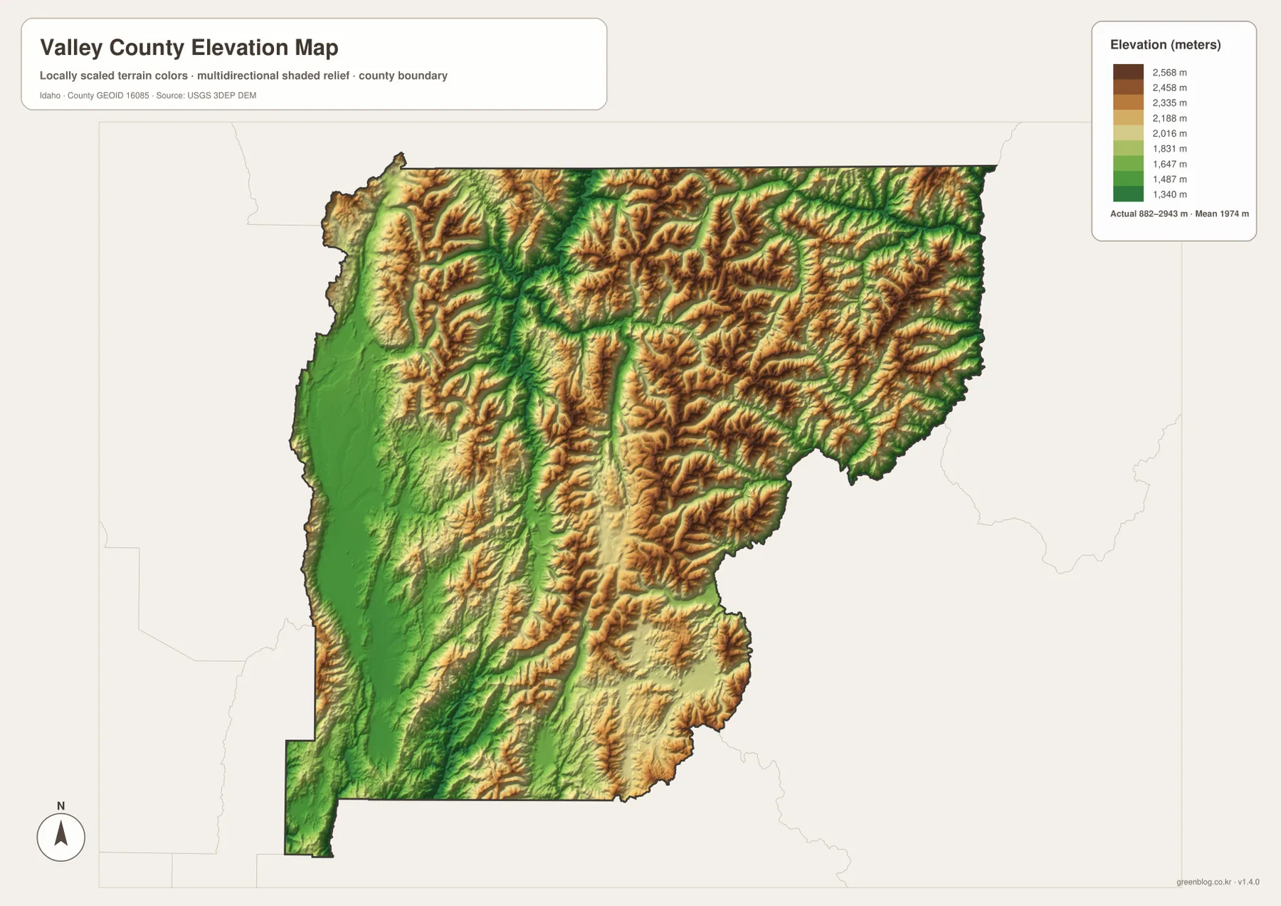
Comparing this map with the road map helps explain why the labeled towns cluster where they do. The western corridor is broad and relatively low, while the mountain interior is cut by repeated ridges and drainage valleys. Roads into the interior wind around that relief, and the water map shows streams following many of the same lower corridors between ridges.
The 882–2,943 meter range applies to the whole county
Do not assign either endpoint to a town simply because the number appears on the legend. The minimum and maximum describe the full dataset within the county boundary. Finding the exact elevation of a home site, road, trail point, lake shore, or summit requires a more detailed elevation source or a professional survey, depending on the purpose.
For county-scale explanation, though, the generalized surface is very useful. It quickly shows that the populated western valley is only one part of Valley County and that most of the interior is mountainous. After locating the Salmon River branches on the water map, the elevation colors also help explain why those streams follow long, twisting valleys through the central and eastern mountains.
Choosing the right Valley County map
Use the general map when you need the county outline, main towns, Idaho 55, Yellow Pine, and the broad road network in one view. Choose the city map when the main question is the relative position of McCall, Donnelly, and Cascade. The terrain-and-water map is best for distinguishing the Payette and Salmon systems and finding features such as Warm Lake or Deadwood Reservoir. The elevation map is the clearest choice for explaining the low western valley and the high mountain interior.
A simple way to use all four together is to keep the McCall–Donnelly–Cascade line as a common reference. Find it on the general map, compare the straight-line spacing on the city map, then look west and east on the water map to see how the Payette and Salmon drainages differ. Finish with the elevation map to see why the settlement corridor occupies a broad low valley while much of the rest of the county is mountainous.
Each map has a defined purpose and should not be pushed beyond it. The general map is not a legal parcel map or live navigation service. The city view is not a demographic table or a driving-distance calculator. The water map does not establish flood risk, boating safety, access, or water rights. The elevation surface is not survey-grade. Within those limits, the set works well for classroom use, presentations, regional orientation, trip preparation, and printed county reference.
Frequently Asked Questions
Why are McCall, Donnelly, and Cascade concentrated on the west side?
The supplied maps place all three communities in the broad, relatively low western valley along the Idaho 55 corridor. Valley County’s official history also says the arrival of the railroad to McCall in 1914 helped Cascade, Donnelly, and McCall become the area’s main population centers. The general and elevation maps make the physical contrast with the eastern mountain interior easy to see.
Are the 12- and 27-mile city labels driving distances?
No. The city map shows straight-line distances from McCall: about 12 miles to Donnelly and about 27 miles to Cascade. Roads do not follow a straight line through a mountain county, so use a current road map or navigation service for driving distance, route conditions, and travel time.
Can the 882–2,943 meter range be used as a town elevation?
No. That range summarizes the lowest and highest values in the supplied county-wide elevation surface. It does not give the precise elevation of McCall, Cascade, Yellow Pine, a lake, a road, or an individual parcel. Use original elevation data or a survey when a specific point height is required.
Map File Information
The high-resolution JPG originals for the Valley County general map, city map, terrain-and-water map, and elevation map are packaged together in one ZIP file. Each image is 3,638 × 2,572 pixels, providing enough detail for large-screen viewing and A3-size printing.
- Included Files: 4 high-resolution JPG maps
- Printable Size: 3,638 × 2,572 pixels each
Related Maps
Sources and References
This article was prepared from the supplied Valley County maps and the official sources below. For legal boundaries, current road or water conditions, and precise point elevations, use the latest data from the responsible agency rather than this explanatory map set.
- Valley County official history – local context for the 1914 railroad, county formation in 1917, Cascade Dam, and Lake Cascade
- U.S. Census Bureau TIGER/Line Shapefiles – county boundary and geographic reference data
- USGS National Hydrography – reference data for rivers, streams, lakes, and reservoirs
- USGS 3D Elevation Program – national elevation and terrain data
Green Map creates custom-edited map images using open geographic data sources such as geoBoundaries, Natural Earth, OpenStreetMap, and government open data.
These maps are edited visual materials, not raw data files, and are provided for education, documents, presentations, and graphic reference.