Payette County sits along the western side of Idaho, and its maps show a strong contrast between a compact group of communities in the west and a much broader landscape of creeks, ridges, and open ground to the east. This Payette County map page shows Payette, Fruitland, and New Plymouth; major roads such as US 95 and ID 52; the Payette River and its tributaries; and a large rise in elevation toward the northeastern corner. You can download the complete map set as high-resolution A3 JPG files in one ZIP from the download box near the end of this page.
The county is easiest to understand by starting with the western settlement corridor. Payette and Fruitland lie close to one another near the western edge, while New Plymouth sits farther southeast. Beyond those communities, the map opens into a much larger area where streams and landform become more prominent than city labels. Comparing the road, water, and elevation maps makes that west-to-east change especially clear.
Table of Contents
A western road corridor linking Payette, Fruitland, and New Plymouth
The general county map is dominated by the north-south line of US 95 along the western side. Payette and Fruitland sit close to that route, while New Plymouth is farther inland where several local and state roads meet. ID 52 continues east from the New Plymouth area, and the map also shows ID 72 plus I-84 and US 30 near the southeastern part of the county. The result is a road pattern that is busiest around the western communities but still reaches into the broader eastern half.
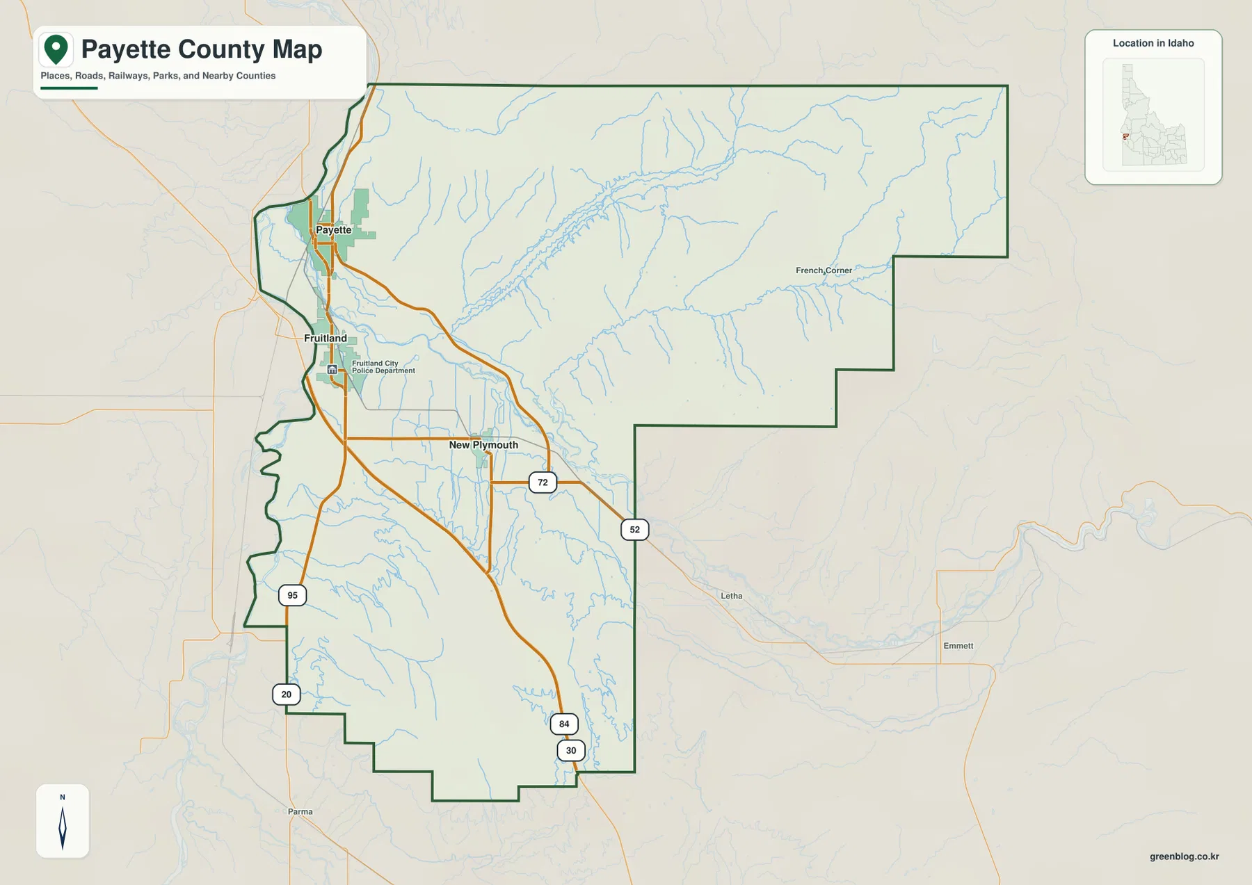
The county outline is not a simple rectangle. Its western side is fairly long and narrow, while the eastern boundary steps outward in several sections. Payette and Fruitland occupy the lower western side of the mapped area, and New Plymouth is set farther southeast. In the east, named communities become sparse and small drainage lines become much more noticeable, which is one reason the water and elevation maps add useful context to the basic road view.
French Corner appears in the northeastern part of the general map, while places outside the county such as Emmett and Letha help show how far the county extends east from its main population corridor. This map is useful for general orientation, road relationships, and county-scale location. It is not a parcel, property-ownership, or legal survey map, so precise boundary questions should be checked against official source data.
Payette as the hub: Fruitland four miles away and New Plymouth nine
The city-connections map uses Payette as the hub and compares it with Fruitland and New Plymouth. The city index printed on the map lists Payette at 8,536, Fruitland at 6,663, and New Plymouth at 1,794. Those are values used in the map’s city dataset rather than a promise of current population, so anyone needing the latest population estimate should use a current official statistical source. What matters for this map is the tight geographic clustering of all three communities in the western part of the county.
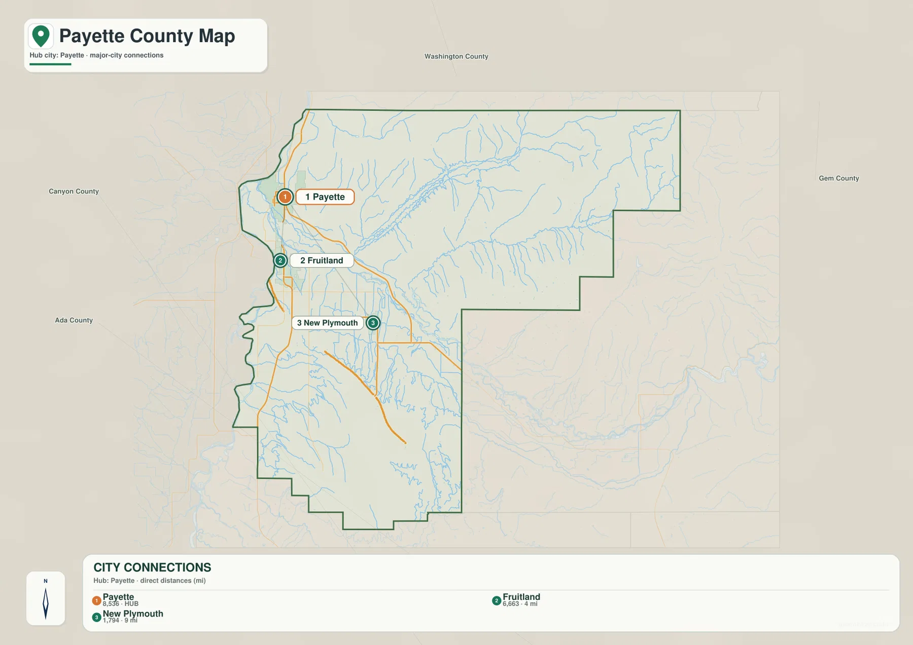
Fruitland is marked 4 miles from Payette and New Plymouth 9 miles from Payette. These figures are straight-line distances between the mapped city points, not driving distances along roads. Actual road mileage will depend on the route, intersections, and the exact starting and ending locations. The map is therefore best used to compare relative spacing and direction rather than to plan a trip mile by mile.
When the city map is compared with the road map, the importance of US 95 becomes obvious. Payette and Fruitland are positioned close to that north-south route, and New Plymouth is connected back toward the same western corridor by the local road network. The absence of major city markers across the large eastern section also emphasizes how concentrated the county’s principal settlements are.
Payette River, Big Willow Creek, and a dense network of canals
The water map shifts attention away from roads and toward the valleys that cross Payette County. The Payette River runs through the western and central part of the county. Big Willow Creek approaches from the east and follows a long lower corridor toward the Payette River, while Little Willow Creek lies farther north. Indian Creek, Dry Creek, and Fourmile Creek drain smaller northeastern valleys, making the upper-right part of the map much more finely divided than the broad lowlands near the western communities.
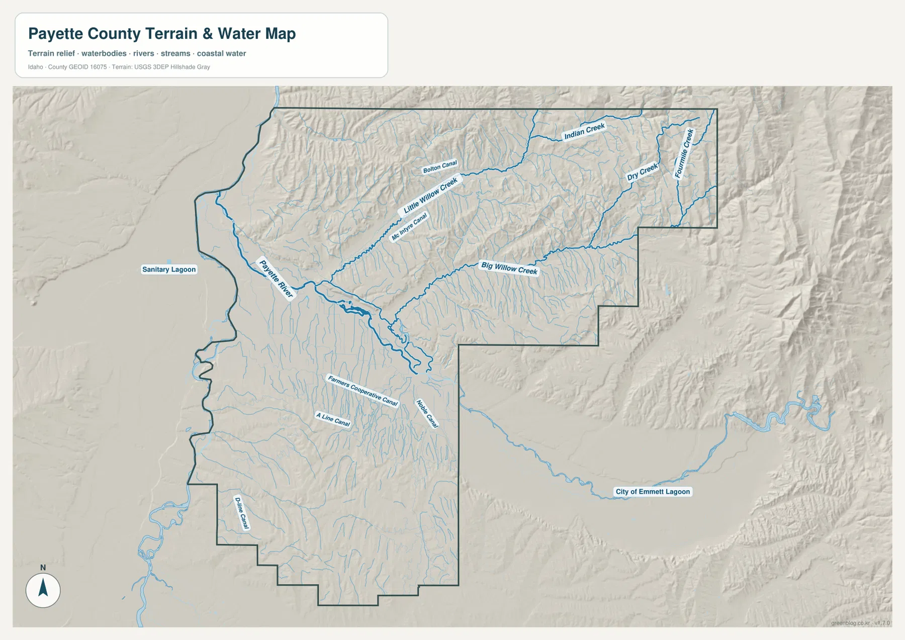
The map also includes several named canals. Bolton Canal and McIntyre Canal appear in the north, while Farmers Cooperative Canal, A Line Canal, and Moses Canal cross the lower central area. Dixie Canal is shown farther southwest. Seeing these artificial channels together with the natural streams helps explain why the low western and central parts of the county contain a much denser pattern of water lines than a simple river-only map would suggest.
The shaded relief behind the water network is important because it shows how drainage follows the land. Short creeks descend through narrow northeastern valleys, Big Willow Creek occupies a longer corridor across the middle, and the Payette River sits in a broader low area to the west. This is a geographic reference map, not a flood-hazard, water-rights, water-quality, depth, or navigation chart.
Elevation rises from 643-meter lowlands to a 1,447-meter northeast high
The elevation map gives Payette County an actual mapped range of about 643 to 1,447 meters, with a mean elevation of about 787 meters. The lowest green colors cover much of the western side and the broad Payette River corridor. The southern half remains comparatively low and gently varied, but the terrain becomes increasingly broken toward the north and east. The highest brown terrain is concentrated in the northeastern corner.
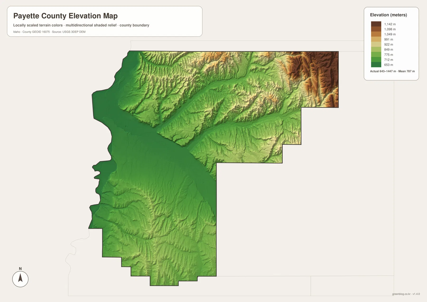
The settlement pattern makes more sense when this surface is compared with the city map. Payette, Fruitland, and New Plymouth all lie close to the greener, lower side of the county. Farther northeast, the map shows repeated ridges and incised valleys instead of a broad low plain. The courses of Big Willow Creek and Little Willow Creek also become easier to understand because their valleys cut through this higher terrain on the way toward the lower central and western areas.
The elevation colors are generalized for county-scale comparison. They should not be treated as survey-grade heights for a house lot, road grade, engineering design, or construction project. For precise measurements, the underlying USGS 3D Elevation Program data or another appropriate survey source should be used.
Choose the map by the relationship you need to see
The general county map is the quickest choice when you want roads, communities, and the county outline in one view. The city map is better for seeing how tightly Payette, Fruitland, and New Plymouth are grouped and for comparing their straight-line spacing. The water map adds the Payette River, Big Willow Creek, Little Willow Creek, smaller creeks, and canals, while the elevation map makes the low west and the higher northeast immediately visible.
- Roads and county orientation: use the general map to compare Payette, Fruitland, New Plymouth, US 95, ID 52, and the county boundary.
- Settlement spacing: use the city-connections map for the 4-mile Payette–Fruitland and 9-mile Payette–New Plymouth straight-line distances.
- Rivers, creeks, and canals: use the water map to locate the Payette River, Big Willow Creek, Little Willow Creek, and the named canal network.
- Relief and height: use the elevation map to compare the roughly 643-meter western lowlands with the 1,447-meter high terrain in the northeast.
The WebP images on this page are sized for convenient viewing online. If you need larger files for printing, classroom work, regional comparison, or personal reference, the ZIP below contains the original high-resolution JPG versions of all four supplied maps. The set lets you compare the same county through roads and settlements, city spacing, water and terrain, and elevation without mixing those subjects into one crowded image.
Frequently Asked Questions
Are the 4-mile and 9-mile city distances driving distances?
No. The 4 miles from Payette to Fruitland and 9 miles from Payette to New Plymouth are straight-line distances between the mapped city points. Road mileage can be longer because real routes follow streets, intersections, and road geometry. Use the city map for relative spacing, not turn-by-turn travel planning.
Which waterways are easiest to identify on the water map?
The Payette River is the main large water feature in the western and central county. Big Willow Creek crosses a long corridor from the east, with Little Willow Creek farther north. Indian Creek, Dry Creek, and Fourmile Creek are also labeled in the northeastern hills, and several canals are named in the lower areas.
Where is the strongest elevation contrast in Payette County?
The western Payette River lowlands are the lowest broad area on the map, while the northeastern corner rises into the highest ridges. The mapped actual range is about 643 to 1,447 meters and the mean is about 787 meters. The elevation surface is useful for regional comparison but not for engineering or parcel-level measurement.
Map File Information
The download ZIP contains the county map, city map, water map, and elevation map as high-resolution A3 JPG files.
- Included Files: county map, city map, water map, elevation map
Related Maps
Sources and references
- U.S. Census Bureau TIGER/Line Shapefiles – county boundary, road, and geographic reference data
- USGS National Hydrography – official hydrography reference for rivers, creeks, and other water features
- USGS 3D Elevation Program – elevation and terrain source data
Green Map creates custom-edited map images using open geographic data sources such as geoBoundaries, Natural Earth, OpenStreetMap, and government open data.
These maps are edited visual materials, not raw data files, and are provided for education, documents, presentations, and graphic reference.