Latah County occupies a varied part of northern Idaho along the Washington border. Moscow and US 95 make the western side easy to orient, while Troy, Deary, Bovill, and the eastern uplands lead into a denser pattern of ridges, valleys, and tributaries. The Palouse River and Potlatch River systems add another layer to the county’s geography. This page focuses on features that are visible on the supplied maps and also provides the same map set as downloadable high-resolution JPG files.
Moscow is the simplest place to begin. US 95 runs north and south through the western portion of the county, and Idaho 8 heads east from Moscow through Troy toward the interior. Potlatch is separated to the northwest, Genesee lies south of Moscow, and Juliaetta sits near the southeastern edge. The western road pattern is relatively open, but the routes become more winding as they enter the hillier north and east.
The official Latah County website places the county and neighboring Whitman County, Washington, within the Palouse region. That regional setting helps explain the contrast between the broad western side and the rougher country toward the east. The WebP images on this page are sized for convenient browsing. The ZIP download contains 2572×3638-pixel JPG versions of the same maps for closer viewing, printing, and offline reference.
Table of Contents
Moscow, US 95, and the roads that turn east into the hills
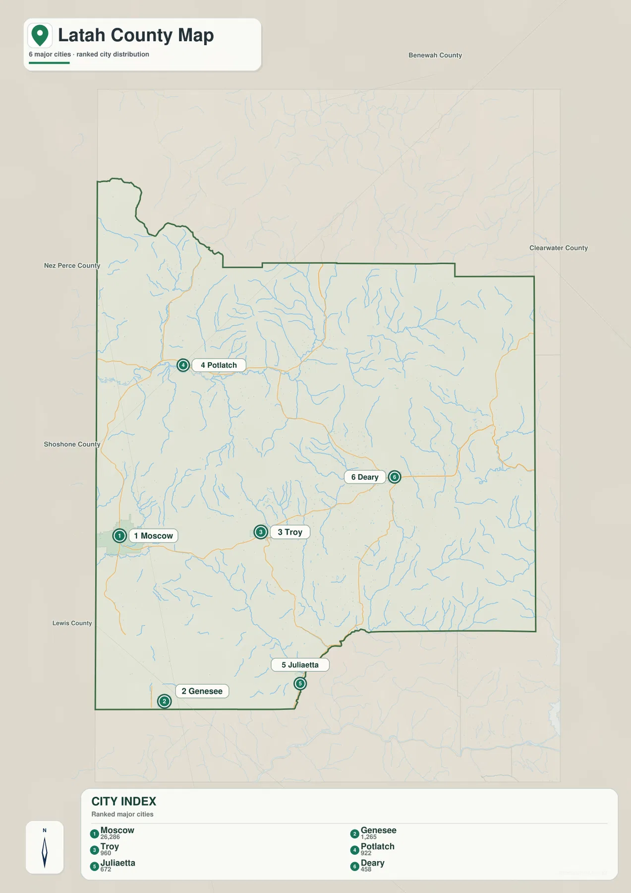
The general county map makes Moscow the strongest western reference point. US 95 passes through the city and continues north and south, while Idaho 8 leaves Moscow to the east and reaches Troy before entering more broken terrain. Genesee is south of Moscow, and Potlatch is farther north near the Idaho 6 area. Once those places are located, the rest of the western half becomes much easier to read.
The road pattern changes as the map moves east. Routes near Bovill bend around valleys and slopes rather than forming the simpler lines seen around the western settlements. Idaho 3 is useful for locating the southeastern part of the county near Juliaetta, while smaller roads connect the communities and drainage corridors between the main state routes. The difference in road shape becomes even clearer when this map is compared with the elevation image later on the page.
Washington lies immediately west of Latah County, with Whitman County across the state line. Moscow’s position near that boundary and the north–south course of US 95 are both easy to see on the map. This is a general geographic reference rather than a parcel or legal road map. Property boundaries, rights-of-way, and other legal questions should be checked against current county or state records.
Six ranked places spread from Moscow to Deary and Juliaetta
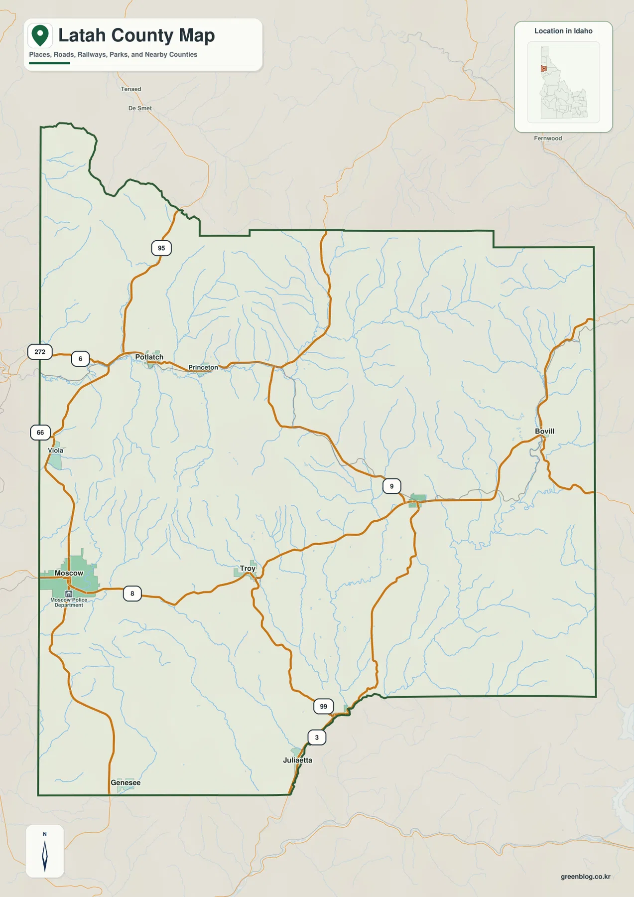
The city-distribution map highlights Moscow, Genesee, Troy, Potlatch, Juliaetta, and Deary. Its printed index lists Moscow at 26,208, Genesee at 1,265, Troy at 960, Potlatch at 922, Juliaetta at 672, and Deary at 458. Those numbers should be treated as values used for the map rather than a claim about the latest population. A dated Census product is the better source for current demographic totals.
The useful feature here is the placement of the six communities. Moscow sits near the western border, Genesee is to the south, and Troy lies farther east. Deary is deeper in the eastern interior, while Potlatch stands apart in the northwest and Juliaetta lies near the southeastern edge. The distribution shows that Latah County’s principal places are spread across several road corridors rather than concentrated along a single line.
Comparing this image with the general map adds road context. Moscow and Genesee are easiest to locate from US 95, Troy from Idaho 8, Potlatch from the Idaho 6 area, and Juliaetta from the southeastern network around Idaho 3. The city map does not draw straight-line connectors between the towns, so it is not intended for measuring mileage. Its main value is a clean view of where the ranked places sit within the county.
Palouse River and Potlatch River branches across the county
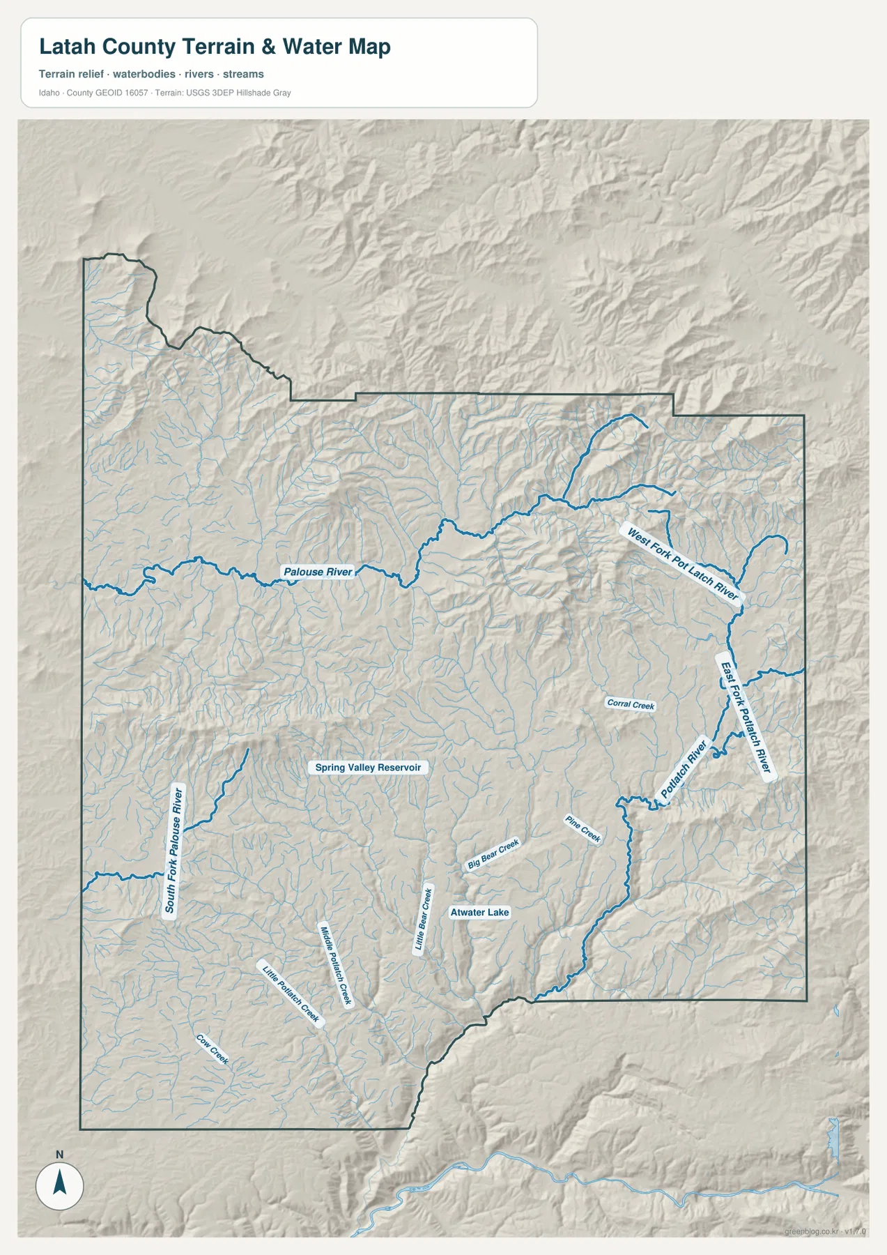
The terrain-and-water map is organized around two major river systems. The Palouse River crosses the northern-central portion of the county, and South Fork Palouse River appears in the west and southwest. Farther east, West Fork Potlatch River and East Fork Potlatch River collect water from many smaller tributaries before joining the larger Potlatch River system. The eastern half contains a particularly dense network of blue lines.
Several smaller names help make the water network easier to follow. Big Bear Creek, Little Bear Creek, Middle Potlatch Creek, Pine Creek, and Corral Creek are among the labeled tributaries. Spring Valley Reservoir and Atwater Lake provide two additional landmarks away from the larger rivers. Starting with the major river names and then following the smaller branches is the clearest way to read the map.
This image is a geographic water reference, not a flood-hazard, depth, navigation, water-quality, or real-time gauge product. Latah County Parks and Recreation lists Spring Valley Reservoir as a county recreation site, so current access and facility information should be checked there before a visit. On this page, the reservoir is most useful as a landmark east of Moscow within the wider drainage network.
From 303-meter valleys to 1,626-meter northern and eastern ridges
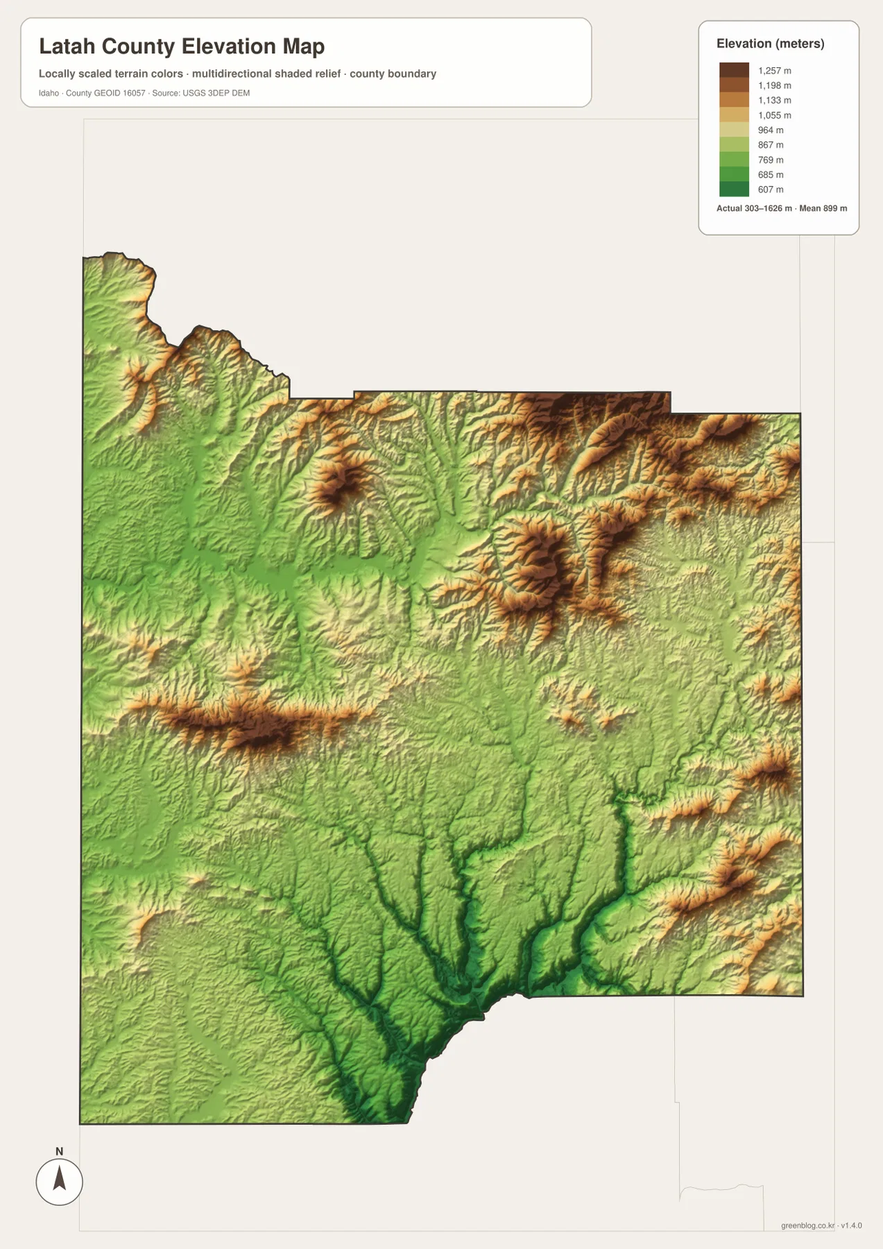
The elevation map reports a county range of about 303 to 1,626 meters and a mean of 899 meters. Lower ground is concentrated in the deeper southern and southeastern valleys and in parts of the west. Higher terrain spreads across much of the north and east. That wide elevation range helps explain why roads and streams look so different between the western settlements and the more rugged interior.
Northern and northeastern ridges form some of the highest areas on the map. Toward the center and south, valleys cut between the uplands and create lower corridors. The southeastern Potlatch River drainage is especially clear because it lies below the surrounding slopes. When the elevation and water maps are viewed together, many tributaries line up with those lower valleys.
The color bands are meant for county-scale comparison. They do not provide survey-grade elevation for a building, road project, parcel, or engineering design. The 303–1,626 meter range and 899 meter mean are useful for describing overall relief, but precise work should use original elevation data such as the USGS 3D Elevation Program and professional surveying when necessary.
How the western Palouse side changes toward the eastern uplands
Latah County’s official description places the county within the Palouse region with neighboring Whitman County in Washington. The region is associated with crops such as wheat, lentils, peas, oats, and barley. That background is useful, but the supplied maps are not land-cover or crop maps. Field boundaries and agricultural acreage should not be inferred from the background colors.
What the maps do show is a clear geographic transition. Moscow and US 95 create a strong western frame, while Idaho 8 leads toward Troy and Deary before the map reaches increasingly broken terrain around Bovill. Juliaetta occupies a lower southeastern corridor near the Potlatch River system. Roads, tributaries, and elevation therefore tell a consistent story without requiring assumptions about land use or ownership.
The general map works best for first-time orientation because it combines towns and roads. The city map strips away much of that detail and makes the six highlighted places easier to compare. The water map is better for river names, reservoirs, and tributaries, while the elevation image shows where low valleys give way to high ridges. Using the files separately is usually clearer than trying to read every topic from one crowded map.
The WebP images are optimized for quick viewing on the page. The downloadable archive contains larger JPG versions of the same maps, each measuring 2572×3638 pixels. Those files are more convenient when small place names, creek labels, and road numbers need to be enlarged or printed. The archive is intended for general reference, study, presentations, and offline use rather than legal, flood, navigation, or engineering decisions.
Frequently Asked Questions
Which map is the best starting point for Moscow, Troy, and Potlatch?
Use the general county map first. It places Moscow on US 95, Troy eastward along Idaho 8, and Potlatch in the northwest near Idaho 6 while also showing nearby communities and the county boundary. The city map is cleaner for comparing the six highlighted places, but it provides less road context.
Where are the Palouse River and the Potlatch River branches shown?
The terrain-and-water map is the appropriate file. It labels the Palouse River, South Fork Palouse River, East and West Forks of the Potlatch River, the main Potlatch River, Spring Valley Reservoir, Atwater Lake, and a number of smaller creeks. It is a location reference rather than a flood, depth, or live water-condition map.
What elevation contrast stands out most in Latah County?
The strongest contrast is between the lower southern and southeastern valleys and the higher ridges across much of the north and east. The map summary gives an overall range of about 303–1,626 meters and a mean of 899 meters. Those values describe county-scale relief and are not substitutes for precise site elevation or surveying.
Map File Information
Download the A3 high-resolution JPG versions of the Latah County maps in one ZIP file for printing, closer viewing, or offline reference.
- Included Files: county map, ranked city map, terrain and water map, elevation map
- Printable Size: 2572×3638 pixels for each JPG
- File Type: ZIP containing 4 JPG files
Related Maps
Sources and references
County background and administrative information are available from the official Latah County website. Information about Spring Valley Reservoir and other county parks and trails is available from Latah County Parks and Recreation.
For underlying geographic reference data, see the U.S. Census Bureau TIGER/Line Shapefiles for boundaries, USGS National Hydrography for rivers and streams, and the USGS 3D Elevation Program for elevation data.
Green Map creates custom-edited map images using open geographic data sources such as geoBoundaries, Natural Earth, OpenStreetMap, and government open data.
These maps are edited visual materials, not raw data files, and are provided for education, documents, presentations, and graphic reference.