Download the Clearwater County Idaho Map as one ZIP containing high-resolution A3 JPG versions of the county overview, city, terrain-and-water, and elevation maps. The WEBP previews below let you inspect Orofino, Pierce, Weippe, Elk River, major roads, the Clearwater River, Dworshak Reservoir, and mountain relief before opening the larger files for printing, classroom work, reports, or presentations.
Clearwater County stretches from the lower Clearwater River valley around Orofino into a long, mountainous eastern interior. Most of the named communities and major roads are concentrated in the west, while the eastern half is dominated by ridges, tributaries, and the North Fork Clearwater River. Dworshak Reservoir forms a major landmark between those two settings, making it easy to see how settlement, water, and relief change across the county.
Table of Contents
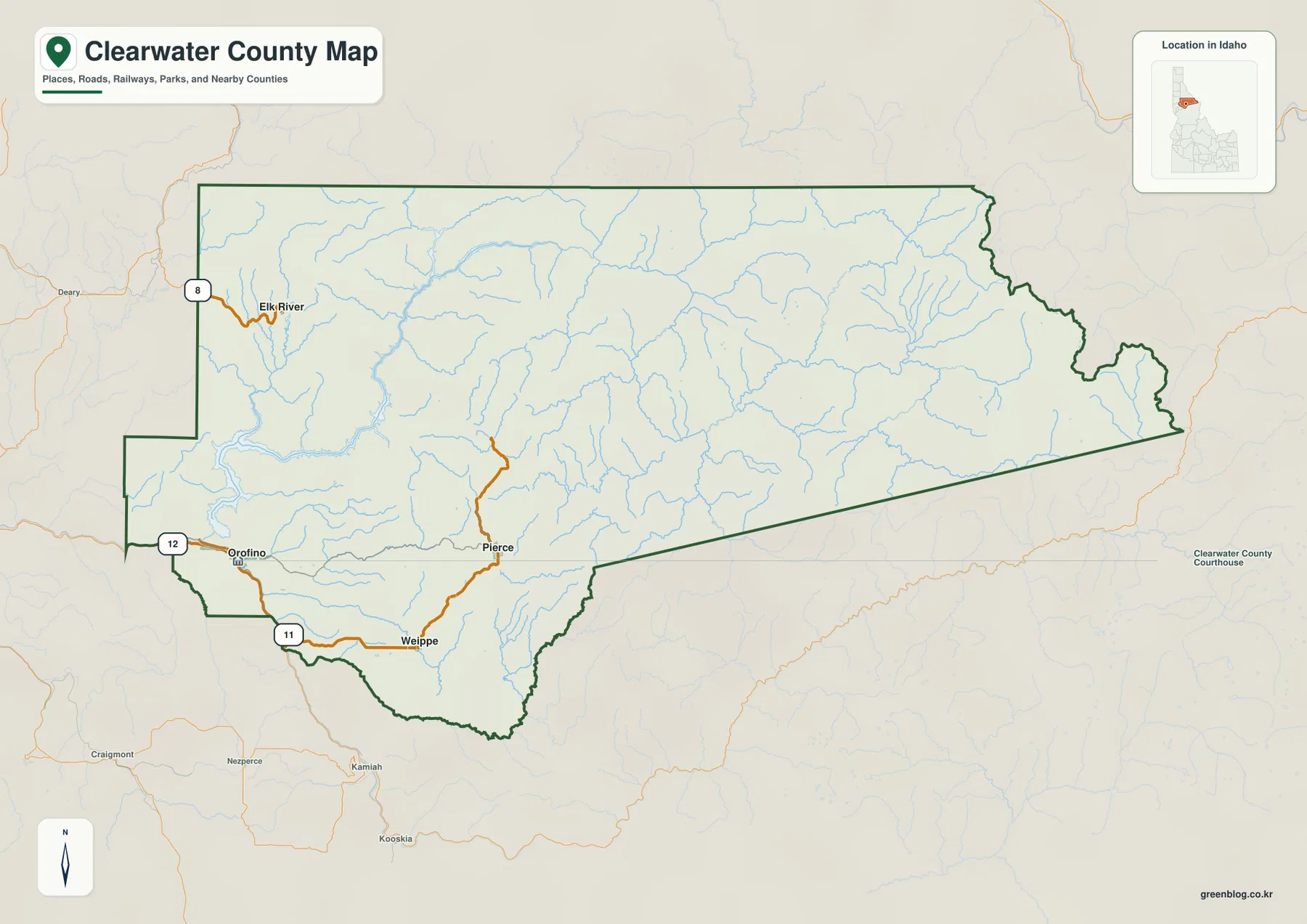
Orofino is the best starting point for the county overview
The county map places Orofino near the southwestern side of Clearwater County along the Clearwater River corridor. Current Idaho court records and the Idaho Blue Book identify Orofino as the county seat. On the map it is also close to US 12 and Idaho 11, so it works as a practical reference point for finding roads, rivers, and the other named communities.
Following Idaho 11 southeast from Orofino leads toward Weippe, with Pierce farther to the northeast. Elk River lies near the northwestern side of the county and is associated with the Idaho 8 corridor. These four places are clustered in the western part of a county whose eastern section extends a long distance into much more rugged country.
The boundary itself changes character from west to east. The western side has several angular steps, while the county narrows into a long eastern reach with a sloping southern edge and a more irregular mountain boundary in the northeast. Numerous blue stream lines become increasingly prominent toward the interior, where roads and settlement labels are much less dense.
The city map compares four communities from an Orofino hub
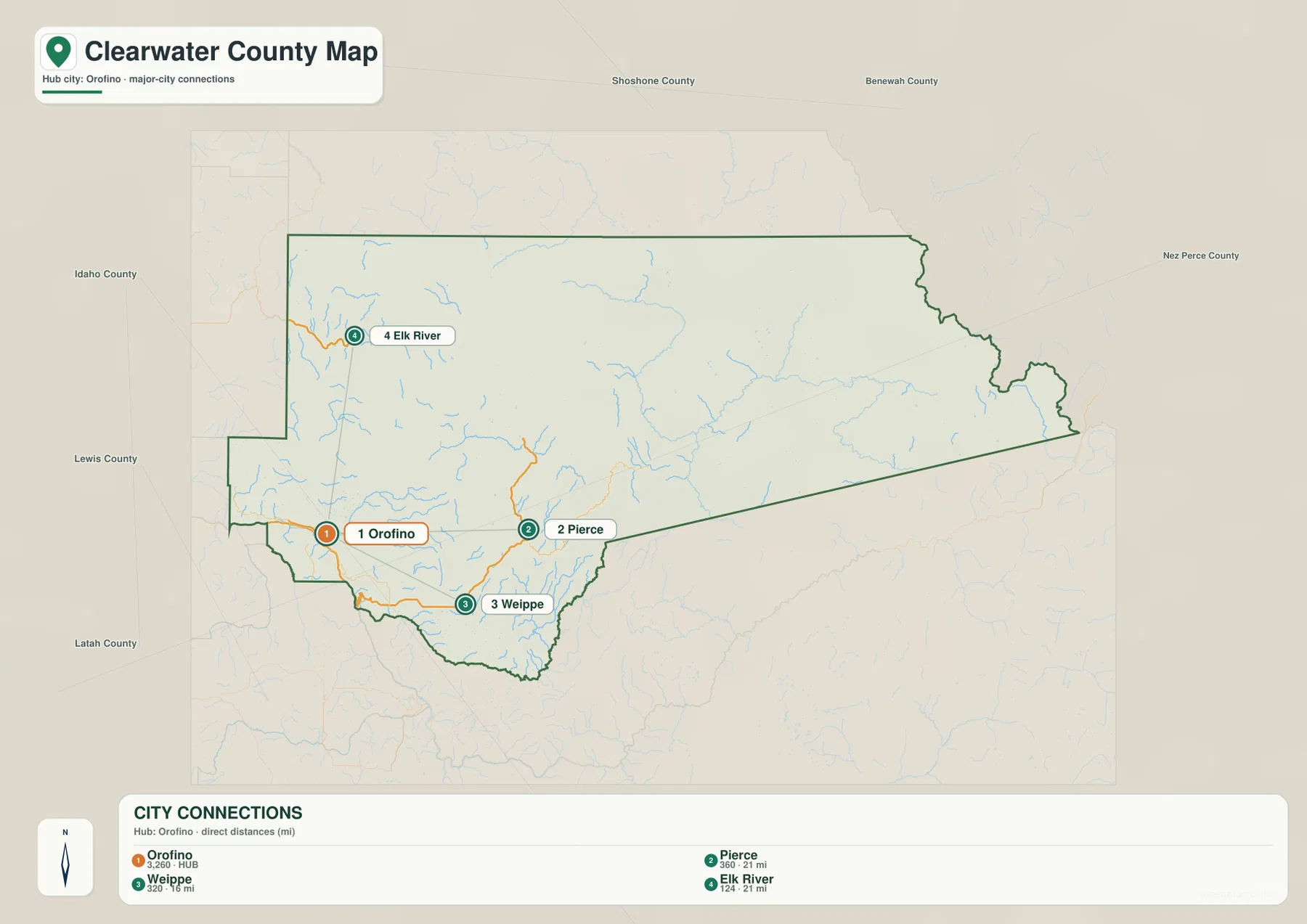
The city-connections map uses Orofino as the hub and shows Pierce, Weippe, and Elk River as the other major labeled communities. The graphic gives straight-line distances from Orofino: Weippe is about 16 miles away, while Pierce and Elk River are each shown at about 21 miles. Those numbers are direct point-to-point distances, not driving distances on mountain roads.
Orofino sits in the southwest, Weippe lies to the southeast, and Pierce is farther east and north. Elk River is separated to the north, giving it a different relationship to the road network than the other three communities. Because the city map removes most secondary detail, it is particularly useful for understanding direction before returning to the full county map.
Once those four places are familiar, the overview adds the transportation context. Orofino and Weippe are connected through the Idaho 11 corridor, Pierce lies farther into the interior, and Elk River is reached from the Idaho 8 side of the county. For classroom or presentation use, the city map works well as the first slide before the more detailed road, water, and elevation views.
Dworshak Reservoir and the North Fork organize the water map
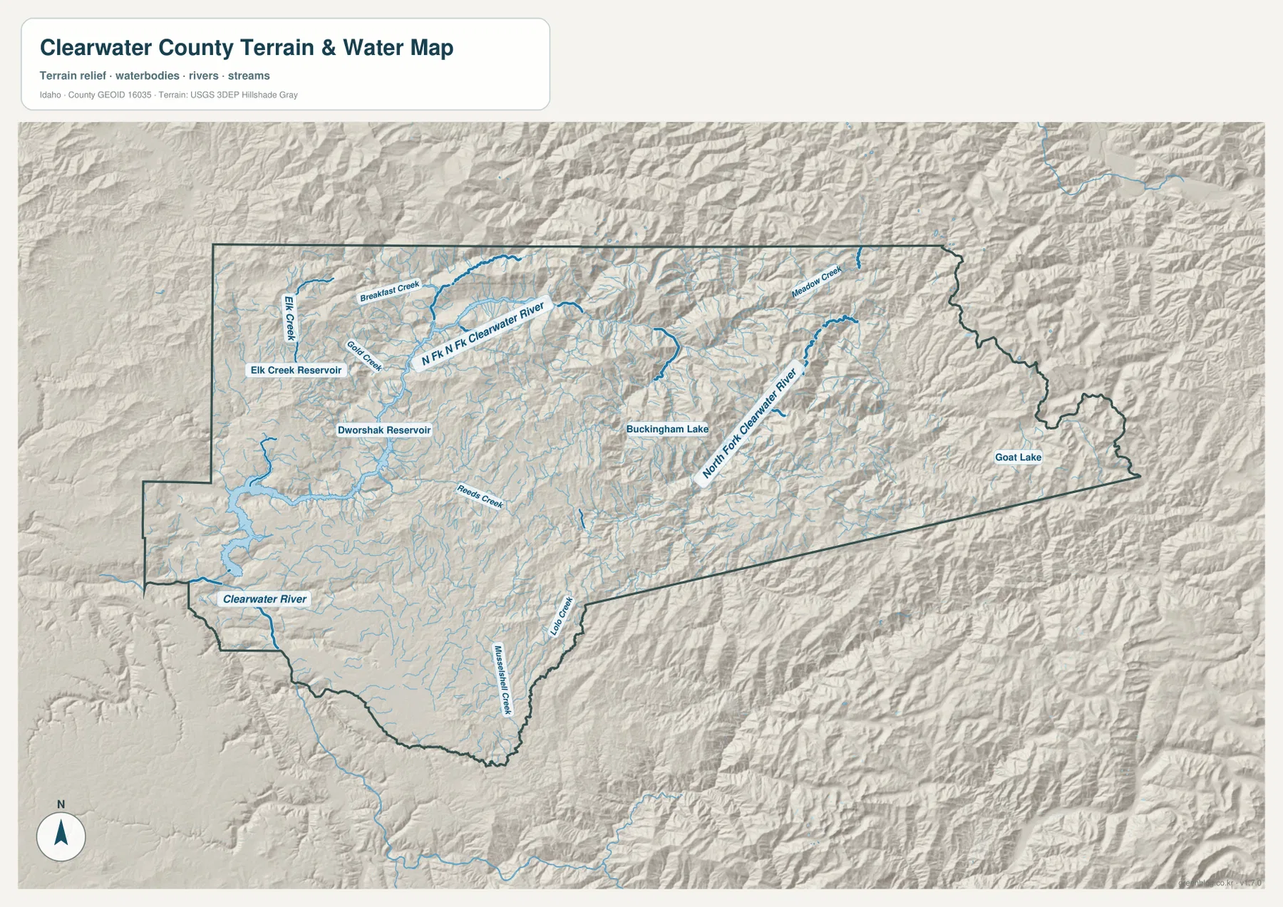
The terrain-and-water map begins in the southwest with the Clearwater River and then quickly becomes more complex around Dworshak Reservoir. The reservoir extends through a branching set of narrow arms in the west-central part of the county, clearly separating the lower Orofino area from the more rugged terrain farther east.
Elk Creek Reservoir appears farther north, with Elk Creek and Gold Creek among the labeled nearby streams. Breakfast Creek and Reeds Creek add smaller tributaries in the western and central sections. The number of branches visible around these waters helps show how deeply the landscape is cut by stream valleys.
Farther east, the North Fork Clearwater River becomes the dominant named waterway. Meadow Creek joins the drainage from the north, while Buckingham Lake is labeled in the central-eastern mountains and Goat Lake appears near the far eastern end. Lolo Creek and Mississippi Creek are labeled in the south. This map is a geographic reference for rivers, creeks, lakes, and reservoirs; it is not a flood-hazard map, depth chart, navigation product, parcel map, or legal water-right document.
Elevation rises strongly from the western river valleys to the east
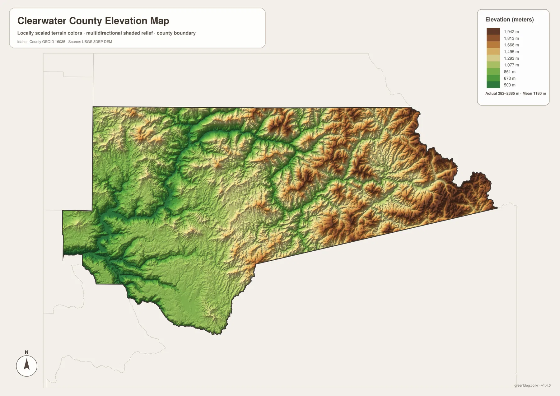
The elevation map shows the western and southwestern valleys in dark green, marking the lowest broad areas of Clearwater County. Orofino and the lower Clearwater River corridor sit within this lower terrain. Moving east, greens give way to yellow, tan, and brown as the county becomes more mountainous.
The supplied elevation graphic reports an actual range of about 282 to 2,385 meters, with a mean near 1,180 meters. Lower green terrain remains common around the western river corridors and parts of Dworshak Reservoir, while the eastern and northeastern mountains contain the widest areas of high brown relief. Many stream valleys appear as lower green channels cutting between higher ridges.
The colors are intended for county-scale comparison rather than property-level measurement. They are useful for seeing why roads and settlements are concentrated in lower valleys and why the eastern interior has fewer major community labels. A survey or engineering project would need a more precise elevation source for an individual site.
Using the maps together connects towns, roads, water, and relief
For ordinary orientation, begin with the city map to locate Orofino, Weippe, Pierce, and Elk River, then switch to the county overview to add US 12, Idaho 11, Idaho 8, and the long county boundary. This sequence makes the road relationships much easier to understand than starting with the detailed terrain.
The terrain-and-water map is the next step when Dworshak Reservoir, the Clearwater River, or the North Fork is the main interest. Once those waterways are located, the elevation map explains why so many tributaries are packed into the eastern interior and why the western settlement area is comparatively accessible.
This combination works well for classrooms, trip planning, local research, presentations, and county-to-county comparisons. A reader can trace Orofino from the city map to US 12 on the overview, then compare the Clearwater River and Dworshak Reservoir on the water map and finally see the low valley setting on the elevation map.
Frequently Asked Questions
Where is Orofino on the Clearwater County map?
Orofino is in the southwestern part of the county along the Clearwater River corridor, close to US 12 and Idaho 11. It is the county seat and the easiest reference point for locating Weippe, Pierce, and Elk River.
Which map is best for finding Dworshak Reservoir?
The terrain-and-water map is the clearest view. Dworshak Reservoir appears as a long, branching water body in the west-central part of the county and can be compared with the Clearwater River, Elk Creek Reservoir, and the North Fork Clearwater River.
Which part of Clearwater County is highest?
The eastern and northeastern mountain areas are the highest parts of the supplied elevation map. The Clearwater River valley in the west and southwest is much lower, and the map reports an overall range of roughly 282 to 2,385 meters.
Map File Information
The ZIP contains high-resolution A3 JPG versions of the Clearwater County overview, city, terrain-and-water, and elevation maps.
- File Type: JPG files inside one ZIP archive
Related Maps
Sources and references
- Clearwater County official website
- Idaho Secretary of State — Idaho Blue Book, Clearwater County
- U.S. Census Bureau TIGER/Line Shapefiles
- USGS National Hydrography
- USGS 3D Elevation Program
Green Map creates custom-edited map images using open geographic data sources such as geoBoundaries, Natural Earth, OpenStreetMap, and government open data.
These maps are edited visual materials, not raw data files, and are provided for education, documents, presentations, and graphic reference.