Download the Blaine County Idaho Map as a high-resolution A3 JPG ZIP, with WEBP previews on this page for quick viewing. The maps follow the Wood River Valley from Hailey through Ketchum and Sun Valley, show the northern lakes and mountain terrain around Alturas Lake, and extend south toward Carey and the county’s long lower reach.
Blaine County is unusually varied from north to south. The northern and northwestern parts are dominated by high mountain terrain and narrow valleys, the main named cities line up along the Big Wood River corridor, and the southeastern and southern sections open into much lower country. A narrow southern extension reaches all the way to the Snake River, giving the county a shape that makes more sense once the road, water, and elevation maps are viewed together.
Table of Contents
The Wood River Valley carries most of the named cities
Hailey is the county seat, and both Blaine County’s current government locations and the Idaho Secretary of State county profile place county administration there. On the map, Hailey also works as the clearest geographic reference point. Ketchum and Sun Valley sit farther north in the same valley system, while Bellevue lies south of Hailey before the land opens toward Gannett and the broader southern part of the county.
The settlement pattern follows the valley rather than the surrounding ridges. Ketchum and Sun Valley are tucked into the northern mountain country, Hailey occupies a wider section of the valley, and Bellevue continues the line of communities southward. Seeing the county boundary, streams, and roads together makes it clear that the populated corridor is a relatively narrow strip inside a much larger mountain landscape.
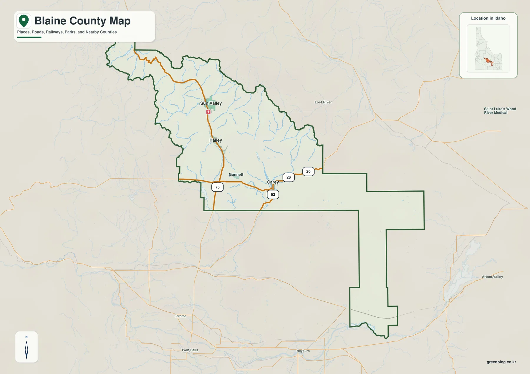
Hailey, Ketchum, Bellevue and Sun Valley cluster tightly; Carey does not
The city map isolates five places and makes the county’s settlement pattern much easier to read. In the supplied city index, Hailey is ranked first, Ketchum second, Bellevue third, Sun Valley fourth, and Carey fifth. The first four are all concentrated in or near the Wood River Valley, with Ketchum and Sun Valley especially close together in the north.
Carey is the outlier. It sits well to the southeast of the Wood River cities, closer to the flatter country and the Little Wood River system. This separation is useful for understanding the county as two connected but different settings: a narrow mountain valley with several closely spaced cities, and a more open southeastern area with fewer named settlements. The map also labels surrounding counties, including Custer, Butte, Bingham, Minidoka, Lincoln, and Elmore, so Blaine County can be placed within south-central Idaho without guessing at neighboring boundaries.
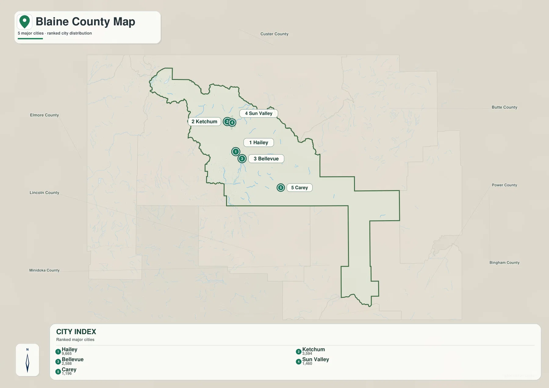
State Highway 75 follows the mountain corridor while southern routes spread outward
State Highway 75 is the easiest road to trace through the populated mountain valley. It runs north from the wider southern area through Hailey toward Ketchum and Sun Valley, closely matching the line of the main cities. When the overview and city maps are compared, the reason for that alignment is obvious: the highway uses the same lower valley passage that holds the major settlements.
The road picture changes near Carey and Gannett. The overview labels US 20 and US 26 across the southern portion of the county and US 93 on a north-south route, creating a broader set of connections than the single mountain-valley corridor farther north. That contrast makes the county useful for map reading: roads in the north are constrained by steep terrain, while the lower southern area gives major routes more room to spread in different directions.
Big Wood River, Little Wood River, lakes and reservoirs divide the county into distinct water settings
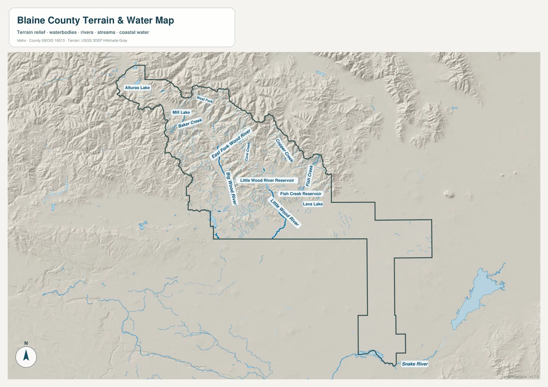
The terrain-and-water map adds far more than a few blue lines. The Big Wood River follows the main valley where Hailey, Ketchum, and nearby communities are located, while the East Fork Wood River and smaller mountain streams enter from surrounding slopes. Baker Creek and the West Fork are among the labeled tributaries in the northern mountain country, where steep relief produces many short drainage lines.
Farther southeast, the Little Wood River becomes the main named river, and two reservoirs stand out: Little Wood River Reservoir and Fish Creek Reservoir. Fish Creek and Cooper Creek feed through that part of the county, while Lava Lake is also labeled nearby. These features sit in a very different landscape from the Big Wood River valley and help explain why the water map is valuable even after the main road map has been understood.
The northwestern mountain area contains a third setting. Alturas Lake and Mill Lake appear among rugged ridges and upper-elevation valleys, separated from the southeastern reservoirs and from the long southern extension of the county. At the very bottom of that extension, the Snake River touches the county edge. This map is a geographic reference for rivers, streams, lakes, reservoirs, and terrain; it is not a flood-risk, parcel, legal-boundary, or navigation chart.
The elevation map separates the high northern mountains from the low southern reach
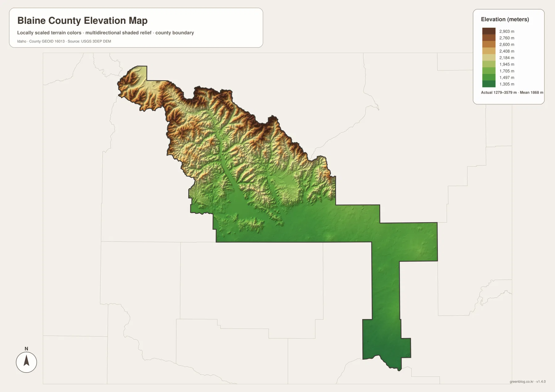
The strongest visual contrast in the entire set appears on the elevation map. Northern Blaine County is covered by brown and orange ridges broken by narrow green valleys, while the southeastern and southern sections are much more consistently green. The Wood River Valley is visible as a lower passage through surrounding mountain terrain, and the relief becomes especially rugged toward the northwest.
The supplied elevation graphic reports an actual range of about 1,279 to 3,579 meters and a mean near 1,868 meters. Those numbers fit what the colors show: the county contains both very high mountain terrain and much lower open country. Carey sits near the transition between the mountainous north and the broad lower southeast, while the long southern extension remains much lower all the way toward the Snake River.
This is a generalized elevation surface for comparing broad height differences, not a survey-grade measurement for a building site, road design, or engineering decision. For everyday map use, its strength is showing where the large changes occur and how closely the main valley, mountain ridges, and lower southern country relate to one another.
The county outline makes more sense when roads, water and elevation are compared
Blaine County has a broad, mountainous northern body and a long, narrower southern extension. On a boundary map alone, that shape can look arbitrary. Once the other maps are considered, the geography becomes easier to follow: the northern half contains the Wood River mountain system and most of the named cities, the southeast opens around Carey and the Little Wood River, and the southern reach continues into lower country toward the Snake River.
The best map to open first depends on the question. Use the overview for road connections and county orientation, the city map for the spacing of Hailey, Ketchum, Bellevue, Sun Valley, and Carey, the water map for rivers and reservoirs, and the elevation map for the dramatic north-to-south terrain difference. Moving between the same places on each view is more useful than treating the maps as unrelated illustrations because it shows how the county’s cities, routes, water, and landforms fit together.
Frequently Asked Questions
How are Hailey, Ketchum, and Sun Valley arranged on the map?
They line up along the Wood River Valley, with Hailey farther south and Ketchum and Sun Valley close together to the north. State Highway 75 follows the same valley corridor, so the overview map is useful for seeing the road connection while the city map gives the clearest comparison of the city locations.
Which map is best for Alturas Lake and Little Wood River Reservoir?
The terrain-and-water map is the best choice. Alturas Lake appears in the rugged northwestern mountain area, while Little Wood River Reservoir is east of Carey in a lower and more open part of the county. Seeing both on the same map highlights how widely different water settings occur inside Blaine County.
Why does northern Blaine County look so much higher on the elevation map?
The northern and northwestern parts contain extensive mountain terrain with high ridges and narrow valleys. The southeastern and southern sections are substantially lower and broader. The color change on the elevation map represents that real regional difference, not merely a different map style.
Map File Information
The larger originals are provided as high-resolution A3 JPG files for the county overview, city locations, terrain and water, and elevation.
- Included Files: Use only the versions confirmed in the article and supplied images
- File Type: Use the confirmed download contents
- Intended Use: Printing, education, presentations, and map-based projects
Related Maps
Sources and references
- Blaine County official website — Our County
- Idaho Secretary of State — Idaho County Profiles
- U.S. Census Bureau TIGER/Line Shapefiles
- USGS National Hydrography
- USGS 3D Elevation Program
Green Map creates custom-edited map images using open geographic data sources such as geoBoundaries, Natural Earth, OpenStreetMap, and government open data.
These maps are edited visual materials, not raw data files, and are provided for education, documents, presentations, and graphic reference.