Download the high-resolution JPG originals for this Yuma County Colorado Map in the ZIP below. The page shows Yuma, Wray, and Eckley, the U.S. 34 corridor, Republican River headwaters, the Arikaree River, lakes and creeks, and an elevation pattern that descends from higher western plains into lower eastern valleys. WebP versions are provided for quick browsing, while the full-size JPG files are better for printing, detailed inspection, and offline reference.
This page covers Yuma County in northeastern Colorado, not the much better-known Yuma County in Arizona. The county’s official website says Colorado’s Yuma County was formed in 1889 from part of Washington County and that Wray has been the county seat since 1902. On the maps, the city of Yuma provides a useful western reference, Wray anchors the eastern side, and Eckley sits between them along the main east-west settlement corridor.
Table of Contents
The U.S. 34 corridor from Yuma through Eckley to Wray
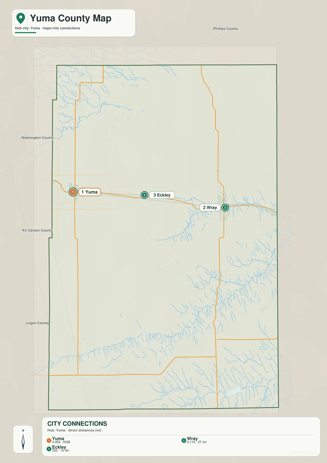
U.S. 34 is the easiest road to use as a reference on the county map because it links Yuma, Eckley, and Wray across the middle-northern part of the county. Yuma sits in a dense grid of rural roads on the western side, while the map shows more visible drainage valleys as the route approaches Wray. U.S. 385 provides a major north-south reference near the Wray–Vernon side of the county, and Colorado 59 appears in the southwest near Kirk.
The City of Yuma’s official site describes Yuma as a northeastern Colorado community about 40 miles from both the Nebraska and Kansas borders. That location helps explain why this county map feels more connected to the High Plains than to Colorado’s mountain corridor. Yuma occupies higher western ground, while Wray lies closer to the lower Republican River drainage. Comparing the road and elevation maps makes that gradual west-to-east change much easier to see.
Straight-line distances from Yuma to Wray and Eckley
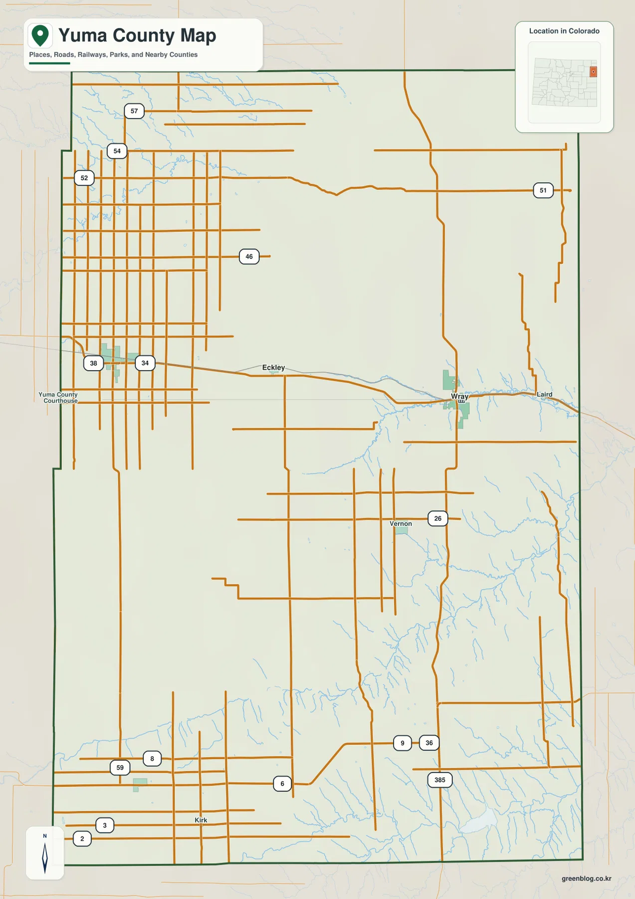
The city-connections map uses Yuma as the hub. It shows Wray about 27 miles away and Eckley about 12 miles away by straight-line distance. These numbers are direct point-to-point measurements rather than road mileage, so they are useful for comparing the spacing of the communities but should not be treated as driving distances or travel-time estimates.
The three places form a simple east-west chain. Yuma is on the western side, Eckley lies between the two larger communities, and Wray is near the eastern side where tributary valleys become more pronounced. Labels for Phillips, Washington, Kit Carson, and Logan counties provide additional orientation and show how Yuma County sits on the far eastern edge of Colorado’s plains.
Republican River headwaters, the Arikaree River, and plains creeks
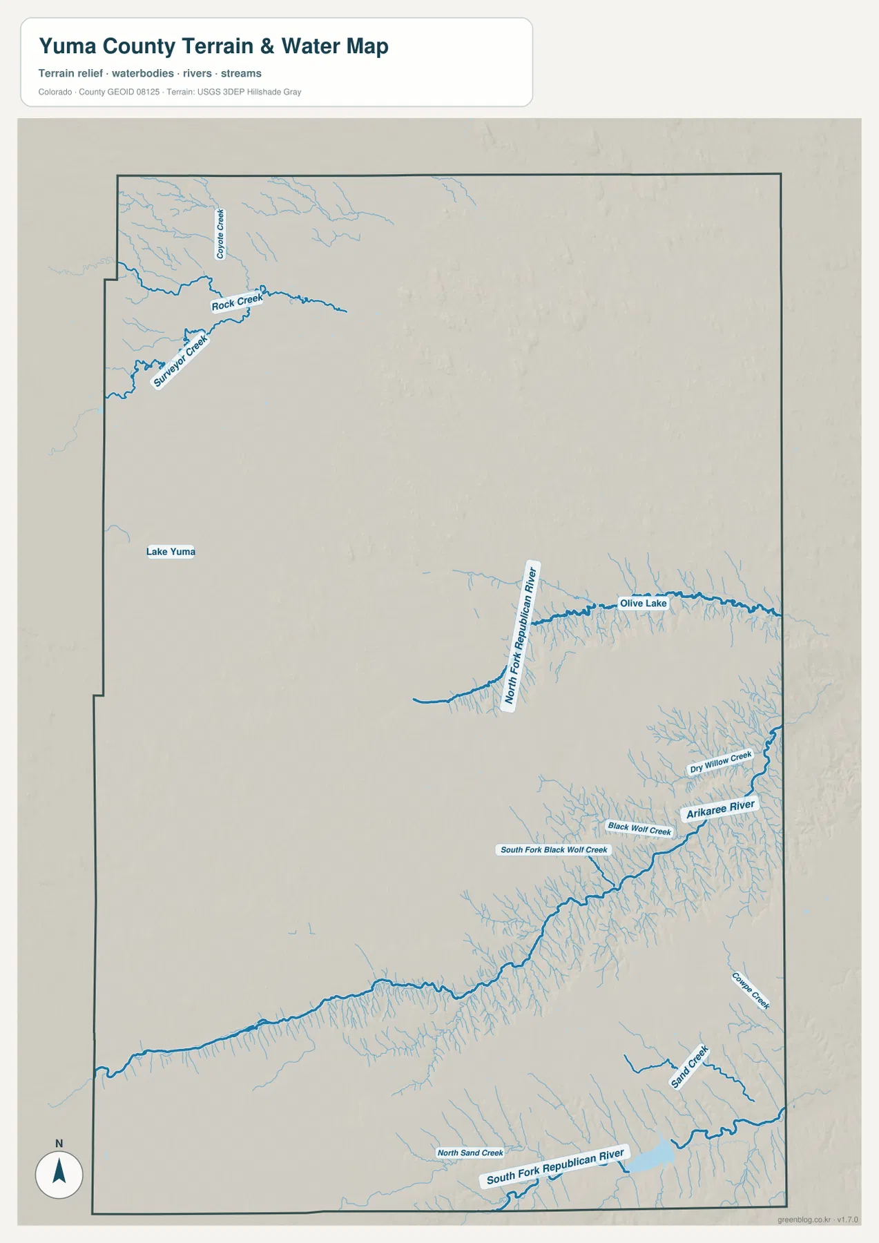
The water and terrain map shows that Yuma County is not a featureless plain. The North Fork Republican River forms one of the most prominent drainage corridors in the east-central part of the county, with Olive Lake labeled along the same general area. Numerous smaller tributaries cut into the surrounding plains, giving the Wray side of the county more visible relief than the broad western uplands.
Farther southeast, the Arikaree River creates another major valley. Dry Willow Creek, Black Wolf Creek, and South Fork Black Wolf Creek are labeled nearby, while the South Fork Republican River and North Sand Creek appear along the southern side. In the northwest, Rock Creek, Surveyor Creek, and Coyote Creek form a separate group of smaller drainages. Rather than a single river gathering every tributary, the county contains several headwater systems spread across a large High Plains landscape.
Lake Yuma is labeled in the west-central part of the county, providing a useful contrast with Olive Lake in the eastern drainage country. This layer is intended for general geographic reference. It should not be used as a flood-hazard map, water-rights document, legal channel boundary, or navigation chart.
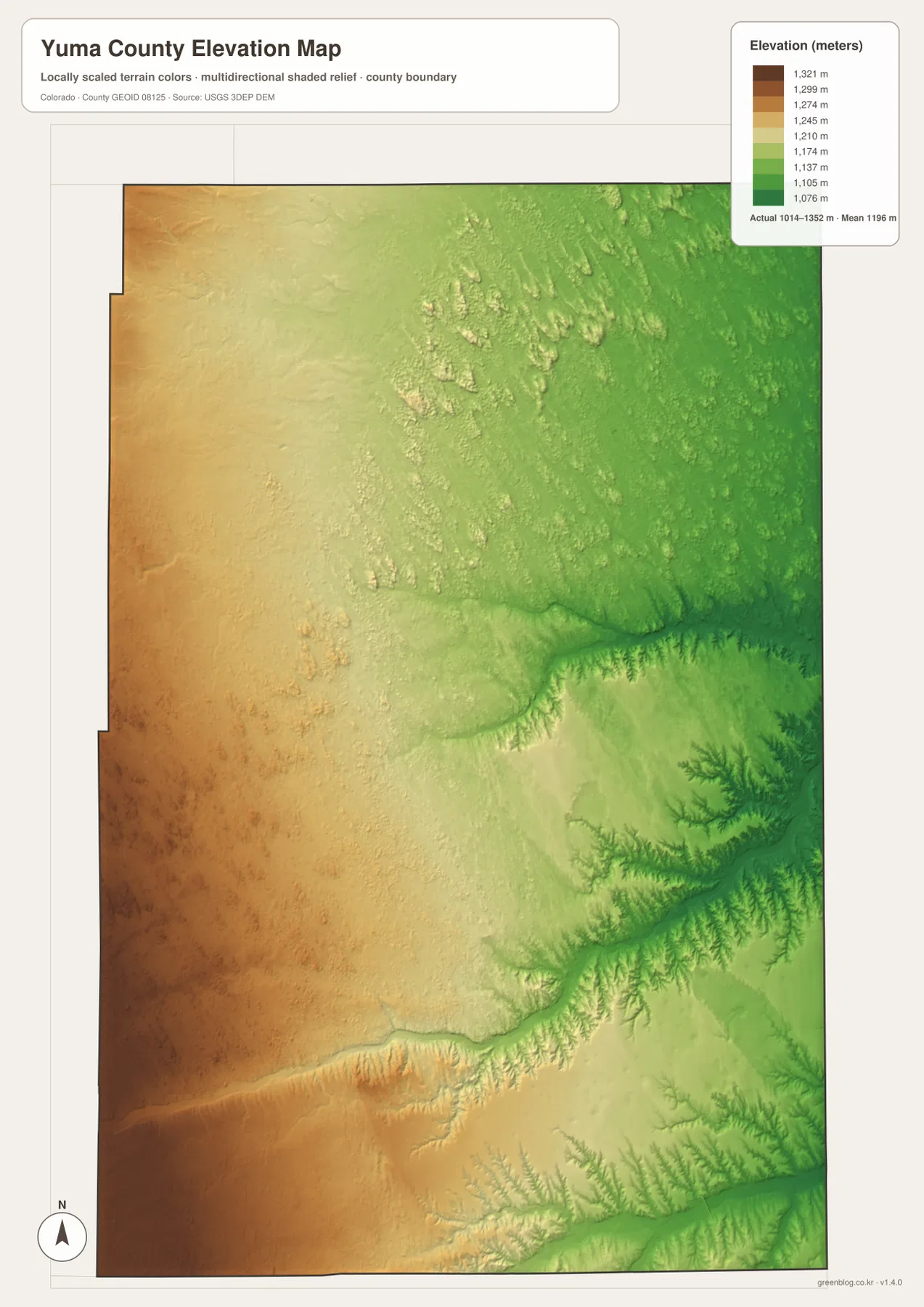
Elevation falls from about 1,352 meters in the west to 1,014 meters in eastern valleys
The elevation map reports an actual county range of about 1,014 to 1,352 meters, with a mean near 1,196 meters. The highest broad terrain appears across the west and southwest in tan and brown tones. Elevation generally decreases toward the east, where greener colors cover the Republican River and Arikaree drainage areas.
The east and southeast contain the county’s most clearly incised valleys. The North Fork Republican River and Arikaree River cut lower corridors through the plains, and many small tributaries branch into those valleys. Even though the road map contains long straight rural roads, the elevation layer makes it clear that the surface is not perfectly flat. The plains are gently tilted and locally dissected by drainage.
This elevation map is intended for broad countywide comparison. It can show where uplands and river valleys differ in height, but it is not survey-grade or engineering-grade data. Property work, drainage design, construction, road engineering, and site-specific elevation questions require authoritative source data or professional surveying.
Why the map hub is Yuma while the county seat is Wray
The city-connections map uses Yuma as its hub, but official Yuma County information identifies Wray as the county seat. Those two facts describe different things. The hub is simply the reference point chosen for comparing city locations and direct distances, while the county seat identifies where county government is based. Yuma County’s official site states that Wray has held the county-seat role since 1902.
The official City of Yuma and City of Wray sites also reinforce the importance of both communities. Yuma anchors the western side of the main settlement corridor, while Wray provides the eastern administrative center in a more dissected river landscape. Eckley lies between them, making the U.S. 34 corridor the clearest way to understand the county’s major population pattern.
Which map should you use first?
Start with the county map when you need Yuma, Eckley, Wray, U.S. 34, U.S. 385, and the county boundary in one view. The city-connections map is best for comparing the straight-line spacing from Yuma to Wray and Eckley. Use the water and terrain layer for the Republican River headwaters, Arikaree River, Lake Yuma, Olive Lake, and smaller creeks. Choose the elevation map when the main question is how the higher western plains transition into lower eastern drainage valleys.
For example, to follow the main settlement corridor from Yuma to Wray, compare the county and city maps first. Add the elevation map to see the broad eastward drop in terrain, and then use the water layer to understand why the Wray and southeastern parts of the county show more pronounced valleys. Using each map for a specific question makes Yuma County’s large High Plains landscape much easier to read.
Frequently Asked Questions
How far are Wray and Eckley from Yuma on the city map?
The city-connections map shows Wray about 27 miles from Yuma and Eckley about 12 miles away. Both values are straight-line distances, not road mileage or estimated driving time.
Is Yuma the county seat of Yuma County, Colorado?
No. Yuma is the hub used by the city-connections map, but the official county website identifies Wray as the county seat and says it has held that role since 1902.
Which map is best for the Republican and Arikaree river systems?
The water and terrain map is the best choice. It shows the North and South forks of the Republican River, the Arikaree River, Rock and Surveyor creeks, Lake Yuma, Olive Lake, and several smaller High Plains drainages.
Map File Information
The ZIP contains the original high-resolution JPG versions of the county, city-connections, water/terrain, and elevation maps shown on this page. Use the larger files for printing, detailed viewing, or offline reference.
- Included Files: Use only the versions confirmed in the article and supplied images
- File Type: Use the confirmed download contents
- Intended Use: Printing, education, presentations, and map-based projects
Related Maps
Sources and references
- Yuma County official website – county formation, northeastern Colorado location, and Wray county-seat information
- City of Yuma official website – Yuma location and community information
- City of Wray official website – Wray community information
- U.S. Census Bureau TIGER/Line Shapefiles – county boundaries, roads, and place reference
- USGS National Hydrography – rivers, streams, and lakes
- USGS 3D Elevation Program – elevation and terrain reference
Green Map creates custom-edited map images using open geographic data sources such as geoBoundaries, Natural Earth, OpenStreetMap, and government open data.
These maps are edited visual materials, not raw data files, and are provided for education, documents, presentations, and graphic reference.