Colusa County spans a sharp geographic change across northern California. The eastern half lies on the broad Sacramento Valley floor, while the western side rises into the Coast Range. The City of Colusa sits near the Sacramento River and serves as the county seat. Williams lies farther west along Interstate 5, with Maxwell to the north and Arbuckle to the south. Stonyford and Lodoga are much farther west in hill and mountain country where roads and streams follow narrower valleys.
You can download the original high-resolution A3 JPG files from this Colusa County Map page in one ZIP. The package contains the county reference map, city-distribution map, and terrain-and-water map. There is no separate elevation map in this package, so terrain descriptions stay with the relief shading and waterways actually shown, supported by official Colusa County geographic information.
Table of Contents
Colusa sits near the Sacramento River while Williams anchors the I-5 corridor
The City of Colusa is the county seat and the most useful reference point on the eastern side of the map. County planning documents place the seat in Colusa, and the reference map labels the Colusa County Courthouse within the city. The county boundary bends strongly just east of town where the Sacramento River forms part of the county’s eastern edge.
Williams provides a different transportation reference. It sits southwest of Colusa along Interstate 5, the county’s main north–south freeway. Colusa County’s official history page notes that I-5 runs through the county, and the map shows the route connecting Maxwell, Williams, and the Arbuckle area. The surrounding terrain is broad and relatively flat compared with the western hills.
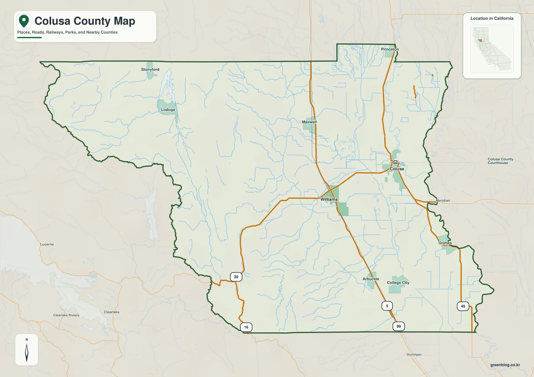
State Route 20 is the easiest road for seeing the county from west to east. It crosses the Coast Range side, reaches Williams, and continues toward Colusa. On the valley floor the route looks comparatively direct; farther west it bends through hill country. Following one highway across both landscapes makes the county’s terrain transition much easier to understand.
Maxwell and Arbuckle sit on the valley floor; Stonyford and Lodoga lie in the western mountains
North of Williams, Maxwell follows the same I-5 corridor. Arbuckle and College City are farther south, while Princeton sits in the northeastern valley and Grimes is close to the Sacramento River side in the southeast. Roads and canals spread across these lowlands in relatively straight lines, giving the eastern half of the county a very different appearance from the west.
Stonyford and Lodoga occupy the opposite setting. The county’s own community history describes Sites and nearby western settlements as tucked into the Coast Range mountains. On the supplied map, relief becomes much stronger west of the central valley, with small streams occupying narrow corridors and road density dropping sharply.
Several state routes help separate these regions. Route 45 follows the Sacramento River side, Route 16 appears in the southwestern foothill area, and I-5 remains the strongest north–south line on the valley floor. These roads are easier to understand when they are paired with the terrain rather than treated as a list of route numbers.
Only Colusa and Williams appear on the incorporated-city map
The supplied city-distribution graphic is intentionally simple. It ranks Colusa first at 6,505 and Williams second at 5,585. Those values are comparison figures printed on the image, not a substitute for current Census estimates. For up-to-date population data, an official statistical source should be used.
Their locations tell the more useful story. Colusa is on the eastern side close to the Sacramento River, while Williams is farther west on I-5. A current Colusa County emergency-planning document identifies Colusa and Williams as the county’s two incorporated cities, which explains why communities such as Maxwell, Arbuckle, Princeton, Grimes, and Stonyford do not appear in this ranked city view.
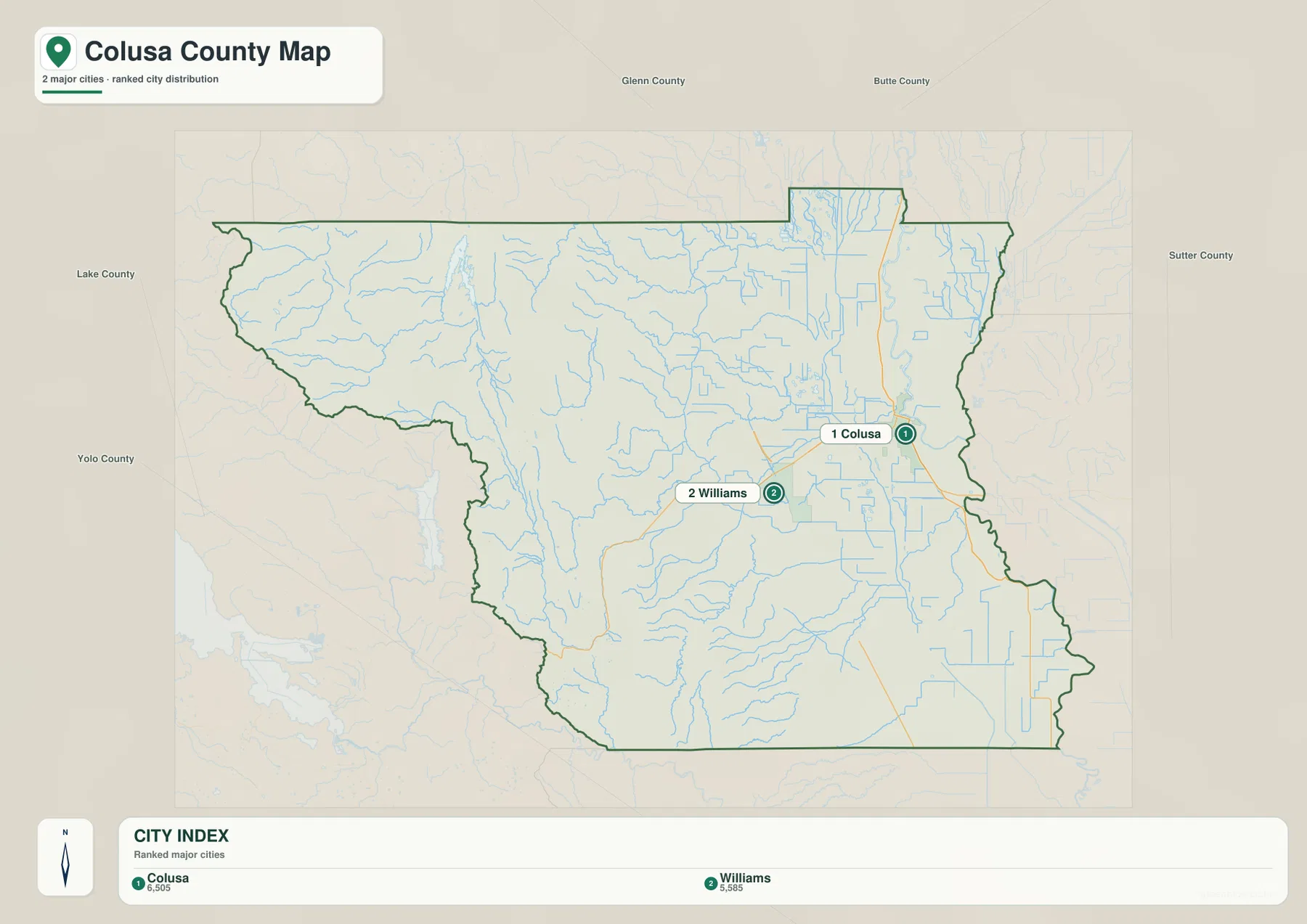
The county reference map remains essential for local orientation because most named communities are unincorporated. The city graphic is best for a quick comparison of the two municipalities; the reference map is better for understanding how those cities fit with Maxwell, Arbuckle, Stonyford, Lodoga, Princeton, and the surrounding road system.
The Sacramento River and valley drainage dominate the eastern side
Colusa County’s official emergency plan places the county in the northern Sacramento Valley and states that the Sacramento River forms part of the eastern boundary. That relationship is visible on the terrain-and-water map, especially along the southeastern edge. The landscape around Colusa and Grimes is broad and low compared with the rugged western side.
The valley contains many straight or gently curving water features in addition to natural channels. The Colusa Trough runs through the central-eastern lowland, and the Glenn-Colusa Canal is also labeled. Colusa County’s official history page notes that the basin floor is agricultural and that country roads are lined with both natural and man-made waterways. The map reflects that mixture clearly.
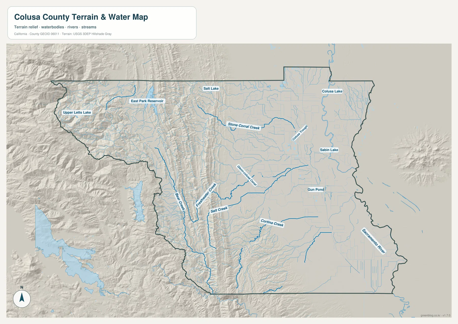
Colusa Lake, Sabin Lake, and Gun Pond provide additional landmarks on the eastern side. The U.S. Fish and Wildlife Service places Colusa National Wildlife Refuge about one mile southwest of the City of Colusa and describes the refuge as primarily wetland habitat. That county-specific setting helps explain why the low eastern landscape contains so many water and wetland features even though the main reference map emphasizes roads and communities.
Stone Corral Creek and western tributaries cut through the Coast Range side
West of the valley floor, the water map changes dramatically. Stone Corral Creek descends from the northwestern uplands toward the central county, while Bear Creek, Freshwater Creek, and Salt Creek occupy separate western and southwestern valleys. Instead of the straighter canal and field-drain pattern of the valley, these streams bend around ridges and follow narrow low ground.
East Park Reservoir and Upper Letts Lake are labeled in the western mountains, and Salt Lake appears closer to the edge of the valley. These features help locate the Stonyford and Lodoga side of Colusa County where town labels are relatively sparse. The combination of reservoirs, steep relief shading, and branching creeks makes the western half visually distinct from the agricultural basin.
An official Colusa County hazard document gives useful context for that contrast: it reports elevations from roughly 30 feet near the Sacramento River in the southeast to about 7,040 feet in the northwestern Coast Range. Those figures come from the county document, not from a separate elevation map in this package. The supplied terrain image should be used for visual comparison rather than precise height measurement.
Williams is a useful midpoint for reading the county from west to east
A simple first pass is to find Williams and use I-5 to establish north and south. Maxwell lies above it, while Arbuckle is below. From Williams, State Route 20 leads east toward Colusa and the Sacramento River side. Following the same route west moves into increasingly rugged terrain where small streams and hill shading replace the open valley pattern.
Stonyford and Lodoga are useful place names in the west, but streams become equally important once the road network thins. Stone Corral Creek and Bear Creek provide better geographic context than settlement names alone. On the eastern side, roads, canals, and the Sacramento River are easier reference points. In other words, the best way to read the map changes as the landscape changes.
Neighboring counties provide additional orientation. Glenn County is to the north, Sutter County to the east, Yolo County to the south, and Lake County to the west. Colusa County planning documents identify the same surrounding counties and note that the western boundary follows the Coast Range watershed divide in places. Near the edge, use the dark county outline rather than assuming a nearby stream or community label falls inside Colusa County.
Choose the map according to whether you need communities, roads, or water and terrain
The county reference map is the best starting point for Colusa, Williams, Maxwell, Arbuckle, Stonyford, Lodoga, highways, and the county boundary. The city-distribution graphic answers the narrower question of how the two incorporated cities compare. The terrain-and-water image is the strongest choice for the Sacramento River, Colusa Trough, western creeks, reservoirs, and the sharp change from the valley floor to the Coast Range.
For teaching or regional explanation, the reference and terrain maps work especially well together. Colusa and Williams can be placed within the flat Sacramento Valley, while Stonyford and Lodoga show the mountain side of the county. Route 20 then provides a practical road connection between those very different settings.
Each downloadable JPG measures 3638 × 2572 pixels and is suitable for A3 landscape printing, enlarging small place labels, or placing a map in a report or classroom handout. Keep the original aspect ratio when resizing so roads, canals, streams, and the county boundary are not distorted. Printer margins vary, so a test page is useful before producing multiple copies.
Frequently Asked Questions
What is the county seat of Colusa County, California?
The City of Colusa is the county seat. It is located near the Sacramento River on the eastern side of the county. Williams, the other incorporated city, lies farther west along Interstate 5.
How many incorporated cities are in Colusa County?
County emergency-planning material identifies two incorporated cities: Colusa and Williams. The supplied city-distribution map shows those same two places, while communities such as Maxwell, Arbuckle, Princeton, Stonyford, and Grimes appear on the broader reference map.
Does this download include a separate elevation map?
No. This Colusa County package contains the county reference map, city-distribution map, and terrain-and-water map. The relief shading shows the strong visual difference between the western Coast Range and eastern Sacramento Valley, but no separate numeric elevation map is included.
Map File Information
The ZIP contains the original Colusa County reference, city-distribution, and terrain-and-water maps as high-resolution JPG files.
- Included Files: County reference map, city-distribution map, terrain-and-water map
- Printable Size: 3638 × 2572 pixels each
- File Type: Three high-resolution JPG files in one ZIP archive
Related Maps
Sources and References
- Colusa County – History and Location – Official county background on Interstate 5, the Sacramento Valley, agriculture, and local waterways.
- Colusa County Emergency Operations Plan – Official geography including the Sacramento River boundary, neighboring counties, and two incorporated cities.
- Colusa County GIS – Official county maps and GIS resources.
- U.S. Fish & Wildlife Service – Colusa National Wildlife Refuge – Official information on the wetland refuge southwest of the City of Colusa.
- USGS National Hydrography – Official U.S. river, stream, lake, and hydrographic data information.
Green Map creates custom-edited map images using open geographic data sources such as geoBoundaries, Natural Earth, OpenStreetMap, and government open data.
These maps are edited visual materials, not raw data files, and are provided for education, documents, presentations, and graphic reference.