Pope County sits where two very different Arkansas landscapes meet. Russellville and most of the county’s larger communities occupy the lower southern part of the county near the Arkansas River Valley, while the northern half rises into the Ozark highlands. That contrast shapes the road network, the spacing of towns, the drainage pattern, and the strong north-to-south change in elevation visible on the maps on this page.
The map set is designed for practical geographic reference rather than a technical GIS workflow. You can locate Russellville, Dover, Hector, Pottsville, Atkins, and London; trace major highways through the southern corridor; follow the Arkansas River and branches of Illinois Bayou; and compare the low river valley with the rugged northern ridges. The original high-resolution JPG files shown here are also available together in a single downloadable ZIP.
County and regional sources support the same broad pattern visible in the maps. Pope County’s official history page identifies Russellville as the county seat and notes the east-west presence of Interstate 40 and the railroad. The Encyclopedia of Arkansas describes northern Pope County as largely within the Ozark National Forest area and the south as part of the Arkansas River Valley. With those two settings in one county, a boundary map alone does not tell the full story; roads, water, settlements, and elevation become much more useful when viewed together.
Table of Contents
Russellville anchors the busy southern edge of the county
On the general county map, Russellville is the clearest urban anchor. Its built-up area spreads across the south-central part of Pope County, with Pottsville immediately to the southeast and Atkins farther east. London lies to the west near the river side of the county, while Dover is north of Russellville and Hector is much farther to the northeast. Smaller labels such as Appleton and Oak Grove help fill in the less urban parts of the county and make the transition away from the Russellville area easier to follow.
The road pattern reinforces that settlement geography. Interstate 40 crosses the southern portion of the county and passes the Russellville–Pottsville–Atkins corridor. U.S. 64 also runs east-west across the same general zone, while Arkansas 7 provides an important north-south route from Russellville toward Dover and the interior. State routes such as 27, 16, 123, 164, 247, and 326 branch through other parts of the county. The southern roads are generally easier to trace as a connected network; farther north, routes bend through narrow valleys and around higher terrain.
The county outline is also worth noticing. Several northern and eastern boundary segments are relatively straight, but the southern edge bends with the Arkansas River, and western sections step inward and outward rather than forming a simple rectangle. Russellville’s position close to the southern boundary is especially important when reading the map because the city is tied geographically to the river valley rather than to the highest terrain in the north.
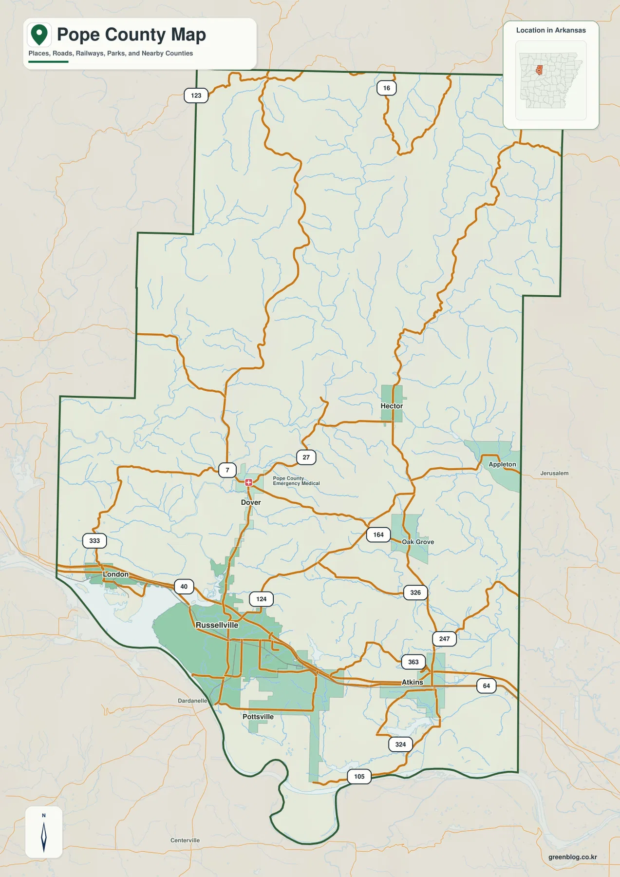
This view works best as the starting map when a reader needs orientation. It answers basic questions such as where Russellville sits within the county, how Dover relates to the southern urban area, where the major east-west corridor runs, and which roads continue into the northern hills. It is also useful as a base reference before opening the water or elevation maps, because the same places can then be compared against streams, lakes, valleys, and ridges.
The city index shows a strong southern concentration
The city map ranks six principal communities: Russellville, Pottsville, Atkins, Dover, London, and Hector. The index printed on the map lists Russellville at 29,162, followed by Pottsville at 3,229, Atkins at 2,877, Dover at 1,795, London at 1,217, and Hector at 334. These figures are best read as the values used in the supplied city index, allowing the viewer to compare relative city size and location on the same page rather than treating them as a stand-alone current population table.
That ranking makes the geographic imbalance obvious. Russellville is not only the largest entry but also occupies the same southern corridor as Pottsville and Atkins. London is west of Russellville near the Arkansas River side of the county. Dover is the first major place north along Arkansas 7, and Hector is isolated farther northeast among a denser pattern of streams and more rugged land. The distance between the southern group and Hector visually emphasizes how quickly the county changes away from the river valley.
Neighboring counties printed around the frame add another useful layer of orientation. Newton County is to the north, Johnson County to the west and northwest, and Yell and Searcy counties appear along the southwestern side. Conway and Van Buren counties are labeled to the east, with Logan County to the southeast. These labels make it easier to understand why the county’s transport and settlement pattern is not centered geometrically; the largest city cluster is pressed toward the Arkansas River side of the county.
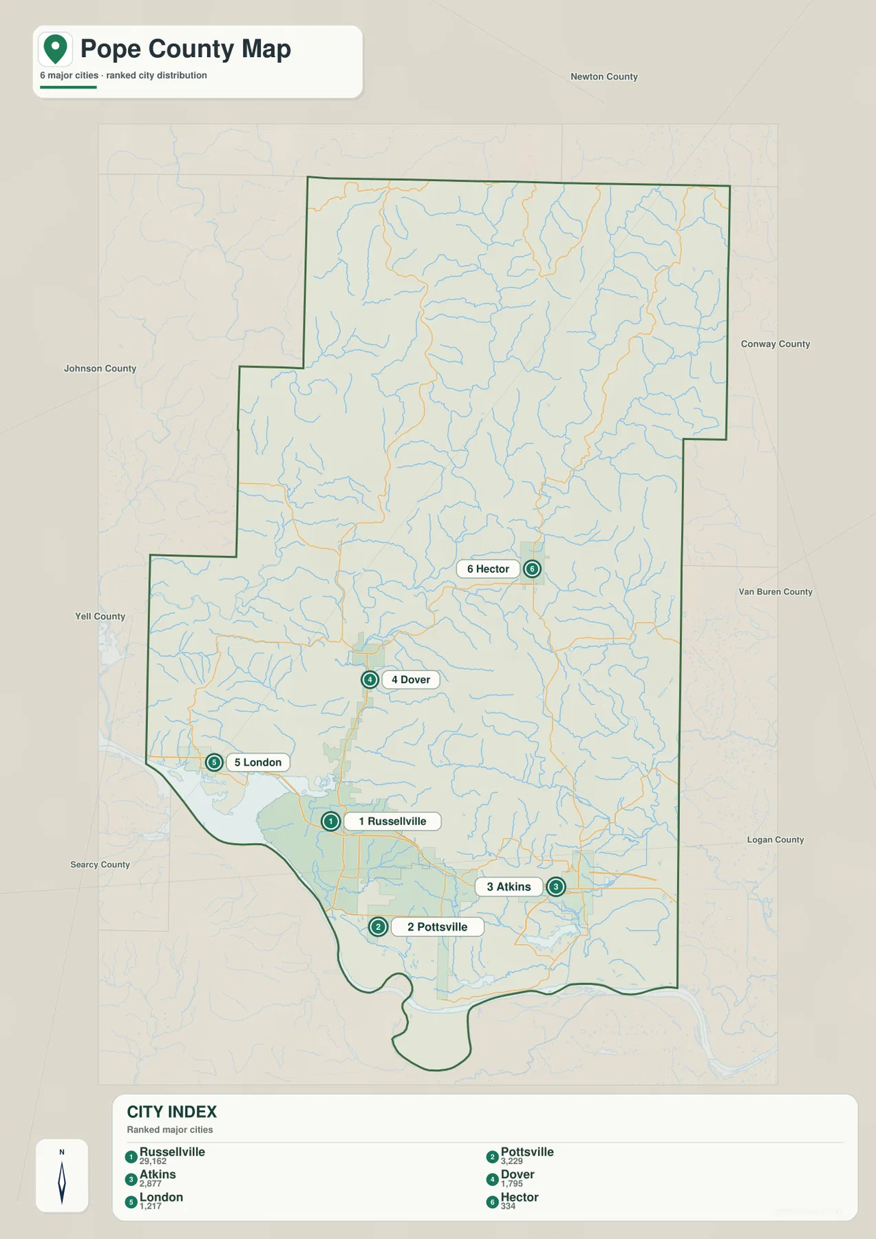
For practical use, compare this city view with the general road map rather than reading the ranking by itself. Russellville, Pottsville, and Atkins line up with the main southern highway corridor, while Dover and Hector sit on routes that extend into higher country. That relationship is useful for classroom explanations, regional summaries, and trip planning at a broad scale because it shows why the most populated places are not evenly spaced across the county.
Waterways descend from Ozark valleys toward the Arkansas River
The terrain-and-water map uses the Arkansas River as the dominant feature along the southern edge. The broad water area west of Russellville is part of the Lake Dardanelle setting on the Arkansas River. Arkansas State Parks describes Lake Dardanelle as an Arkansas River reservoir lying west of Russellville in Pope and Yell counties. That river-and-reservoir landscape contrasts sharply with the narrow streams that drain the interior and northern uplands.
In the north, three named branches of Illinois Bayou stand out: North Fork Illinois Bayou, Middle Fork Illinois Bayou, and East Fork Illinois Bayou. They descend through long valleys separated by ridges. The shaded terrain makes this relationship easy to see because blue stream lines repeatedly occupy the lower channels between higher slopes. Rather than looking like one broad lowland river, the northern drainage is divided among many narrow tributary valleys.
Other named features fill in the middle and southern portions of the county. Mill Creek and Little Creek appear near the center, with Illinois Bayou continuing farther south. Hughes Creek and Isabell Creek are labeled in the east and southeast, while Gum Log Creek and Galla Creek run closer to the southern river valley. Galla Creek Lake, Flagg Lake, and Lake Atkins provide additional local reference points. Lake Atkins is especially easy to connect with the city map because it lies near Atkins in the southeastern part of the county.
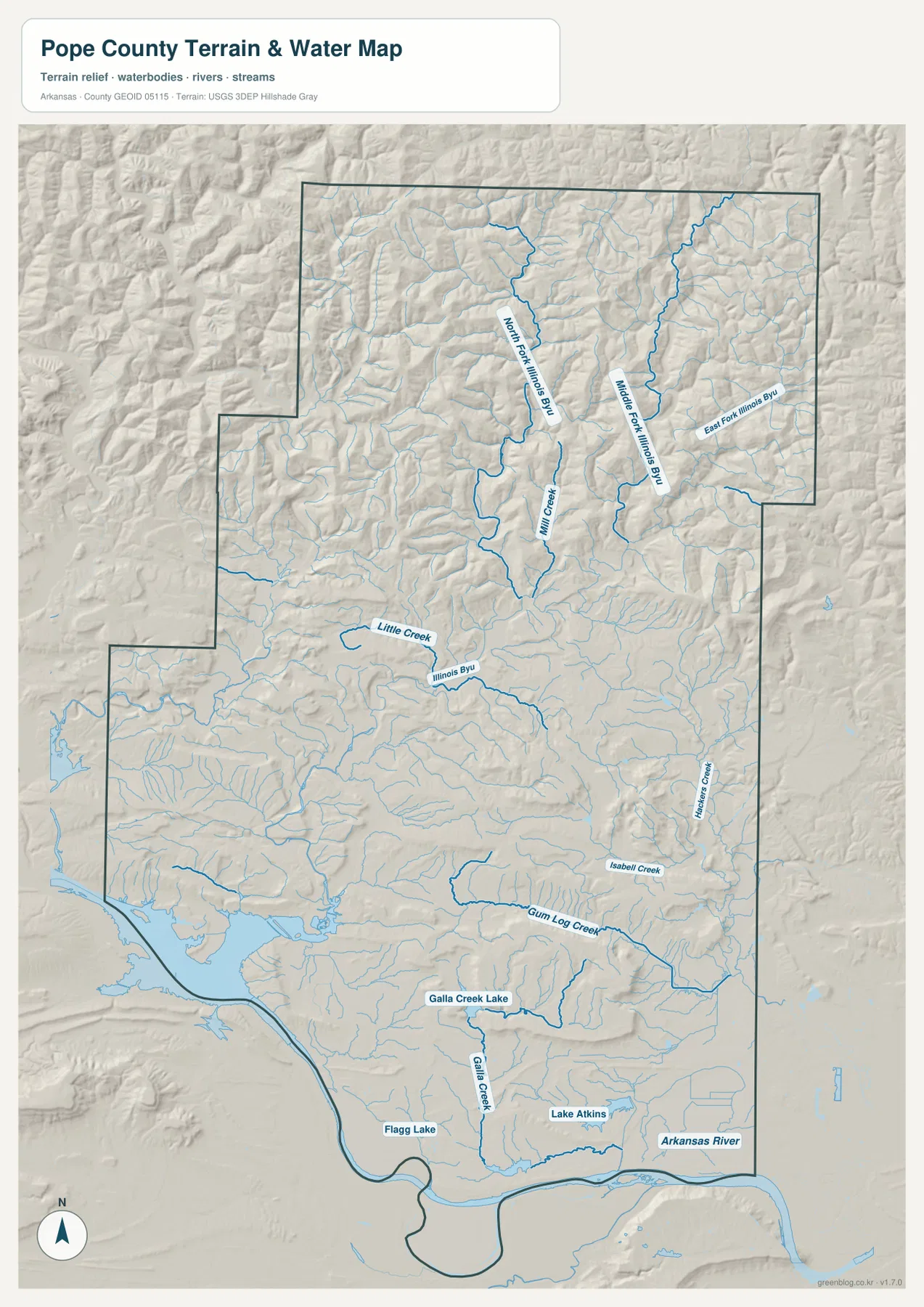
Use this map as a geographic water reference, not as a flood-risk, property, or navigation chart. Its value is in showing where major named waterways lie and how streams fit into the surrounding terrain. It is particularly useful when paired with the elevation map: valleys that carry the Illinois Bayou branches become much easier to recognize when the same area is viewed by height.
Elevation rises sharply north of the river valley
The elevation map gives the clearest single view of Pope County’s north-south contrast. Deep green dominates the southern Arkansas River Valley around Russellville, Pottsville, and Atkins. Moving north, the colors shift through lighter green and yellow into brown, revealing increasingly high ridges and steeper relief. The northern and northeastern sections contain many closely spaced ridges, while the south has broader low areas and fewer dramatic elevation changes.
The legend reports an actual elevation range of about 86 to 671 meters and a county mean of 255 meters. A difference of more than 500 meters between the lowest and highest parts is substantial for one county and helps explain why the landscape changes so visibly from south to north. The higher browns are concentrated in the northern uplands, while elongated green corridors cut between them where streams and valleys descend toward lower ground.
The middle of the county acts as a transition zone. Terrain becomes more broken north of Dover, and the country around Hector and farther north is notably more rugged than the Russellville area. In the south, broader green lowlands coincide with the largest concentration of roads and communities. Comparing the elevation and city maps therefore gives a straightforward picture: the largest urban cluster occupies the lower river-valley side of the county, while smaller communities extend into higher, more dissected terrain.
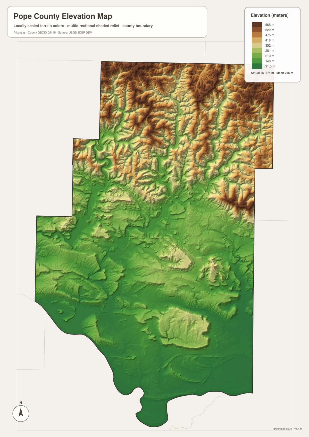
The colored surface is intended for county-scale terrain comparison. It should not replace survey-grade elevations, engineering measurements, or site-specific field data. For a reader studying regional geography, however, it clearly explains why northern roads curve more, why streams occupy long narrow valleys, and why the southern transportation corridor has more room for large connected settlements.
Following one place across all four views reveals the county structure
A useful way to work with the set is to choose one familiar place and trace it across the different views. Start with Russellville. The general map shows the city beside I-40, U.S. 64, and Arkansas 7. The city map confirms its dominant position among the six ranked communities. The water map places it close to the Arkansas River and Lake Dardanelle setting, while the elevation map shows that the city occupies comparatively low terrain.
Dover provides a different example. It lies north of Russellville along Arkansas 7 and is much smaller on the city index. On the terrain maps, the land around and north of Dover becomes increasingly broken. Streams occupy more obvious valleys, and the road network begins to follow the shape of the hills rather than the broad southern corridor. Continuing toward Hector makes the contrast even stronger because Hector sits farther northeast in a landscape filled with tributaries and ridges.
Atkins offers an east-side comparison. It lies on the southern corridor near U.S. 64 and I-40, and Lake Atkins appears close by on the water map. The elevation surface remains relatively low compared with northern Pope County. Looking at the same place across all four maps turns separate layers into one coherent geographic story: settlement, transportation, water, and terrain are not randomly distributed but repeatedly reflect the divide between the Arkansas River Valley and the Ozark uplands.
Choosing the best map for printing, study, or reference
For a quick location check, the general county map is usually the best first choice because it combines community names, major roads, waterways, and the outer boundary. The city map is more focused when the goal is to compare Russellville with Pottsville, Atkins, Dover, London, and Hector. It also helps when neighboring counties matter, because their names are printed around the frame.
Choose the terrain-and-water map when the Arkansas River, Illinois Bayou forks, creeks, or local lakes are the subject. Its shaded background gives the water features enough relief context to show why streams follow certain corridors. Choose the elevation map when the main question is height: it makes the low southern valley and high northern ridges immediately visible without requiring the reader to interpret a dense road network.
For presentations or lessons, a simple sequence works well: orient the audience with the general map, show the city map to explain the southern population concentration, then use the water and elevation views to explain the change into the Ozarks. For a printed report, using only the map that supports the topic often produces a cleaner page than trying to show every layer at once.
The downloadable archive contains the same four map subjects presented on this page as original high-resolution JPG files. Each image measures 2572 × 3638 pixels, giving more detail than the WebP page previews. You can keep the full set for comparison or select only the county, city, water, or elevation image needed for a document, lesson, handout, or presentation.
Frequently Asked Questions
Which map is best for locating Russellville and the Arkansas River together?
Start with the general county map if you need Russellville, major highways, and the county outline on one page. It places Russellville beside I-40, U.S. 64, and Arkansas 7 while also showing the river along the southern boundary. Open the terrain-and-water map next when you need named creeks, lakes, and the broader Arkansas River drainage in more detail.
How can I see the elevation difference between southern and northern Pope County?
The elevation map makes the contrast easiest to see. Dark green low terrain dominates the Arkansas River Valley in the south, while yellow and brown ridges become much more common toward the north. The legend gives an overall range of roughly 86 to 671 meters with a mean of 255 meters, so the vertical difference within the county is large enough to be visually obvious.
Can the water map be used for flood, property, or navigation decisions?
No. It is a county-scale reference showing named rivers, creeks, lakes, and surrounding terrain. Flood hazards, property boundaries, construction decisions, and navigation require current purpose-built information from the responsible government or professional source.
Map File Information
The ZIP contains four high-resolution JPG maps of Pope County covering general reference, city distribution, terrain and water, and elevation.
- Included Files: County map, city map, terrain-and-water map, and elevation map
- Printable Size: 2572 × 3638 pixels each
- File Type: Four JPG files in one ZIP archive
Related Maps
Sources and references
Pope County official County History provides county background, identifies Russellville as the county seat, and describes major east-west transportation through the county.
Encyclopedia of Arkansas: Pope County provides regional context for the Ozark National Forest area in the north and the Arkansas River Valley in the south.
U.S. Census Bureau TIGER/Line Shapefiles is an official reference for U.S. county boundaries and related geographic linework.
USGS National Hydrography is an official reference for U.S. rivers, streams, lakes, and other hydrographic features.
USGS 3D Elevation Program provides official elevation-data background for terrain products.
Arkansas State Parks includes Lake Dardanelle State Park near Russellville and provides official regional information about the Arkansas River reservoir setting.
Green Map creates custom-edited map images using open geographic data sources such as geoBoundaries, Natural Earth, OpenStreetMap, and government open data.
These maps are edited visual materials, not raw data files, and are provided for education, documents, presentations, and graphic reference.