Poinsett County in northeastern Arkansas is divided by one narrow feature that changes nearly everything around it: Crowley’s Ridge runs north-south through the middle of the county. Download Map Files: get all four high-resolution JPG maps together in one ZIP. Harrisburg, the county seat, sits on that higher ground. West of the ridge, the Cache River and L’Anguille River cross a gentler plain; east of it, the St. Francis River, Tyronza River, and a maze of channels occupy much lower Delta country. The elevation map shows an actual range of about 54 to 136 meters with a mean near 71 meters, making the central ridge stand out sharply from both sides.
Harrisburg is the best place to begin reading the county. The Encyclopedia of Arkansas identifies it as the county seat and places the city directly on Crowley’s Ridge. County background material also describes the ridge as a central highland separating different agricultural and drainage landscapes. On the supplied maps, Harrisburg occupies the middle of a narrow elevated strip, while Trumann, Marked Tree, Lepanto, and Tyronza are spread across lower eastern ground and Weiner lies well to the west.
Table of Contents
Roads spread away from the Harrisburg ridge toward two very different plains
The general map places Harrisburg near the center, with Route 1 running north-south and several local roads crossing the ridge toward the east and west. Routes 163 and 373 appear south of town, while the westbound road continues toward Waldenburg. Because Harrisburg occupies the higher ridge rather than the broad lowland, roads approaching the city cross a noticeable change in terrain that becomes obvious when the general and elevation maps are viewed together.
Trumann forms the strongest northeastern road center, with Routes 69 and 463 prominent around the city. Route 63 continues south toward Payneway and Marked Tree, where Route 14 becomes another useful reference. Farther east, Routes 308 and 555 connect toward Lepanto and Tyronza. Route 135 appears near Lepanto, while Routes 118 and 149 serve the southeastern side. Much of this eastern network crosses flat Delta ground, so long straight road sections are common.
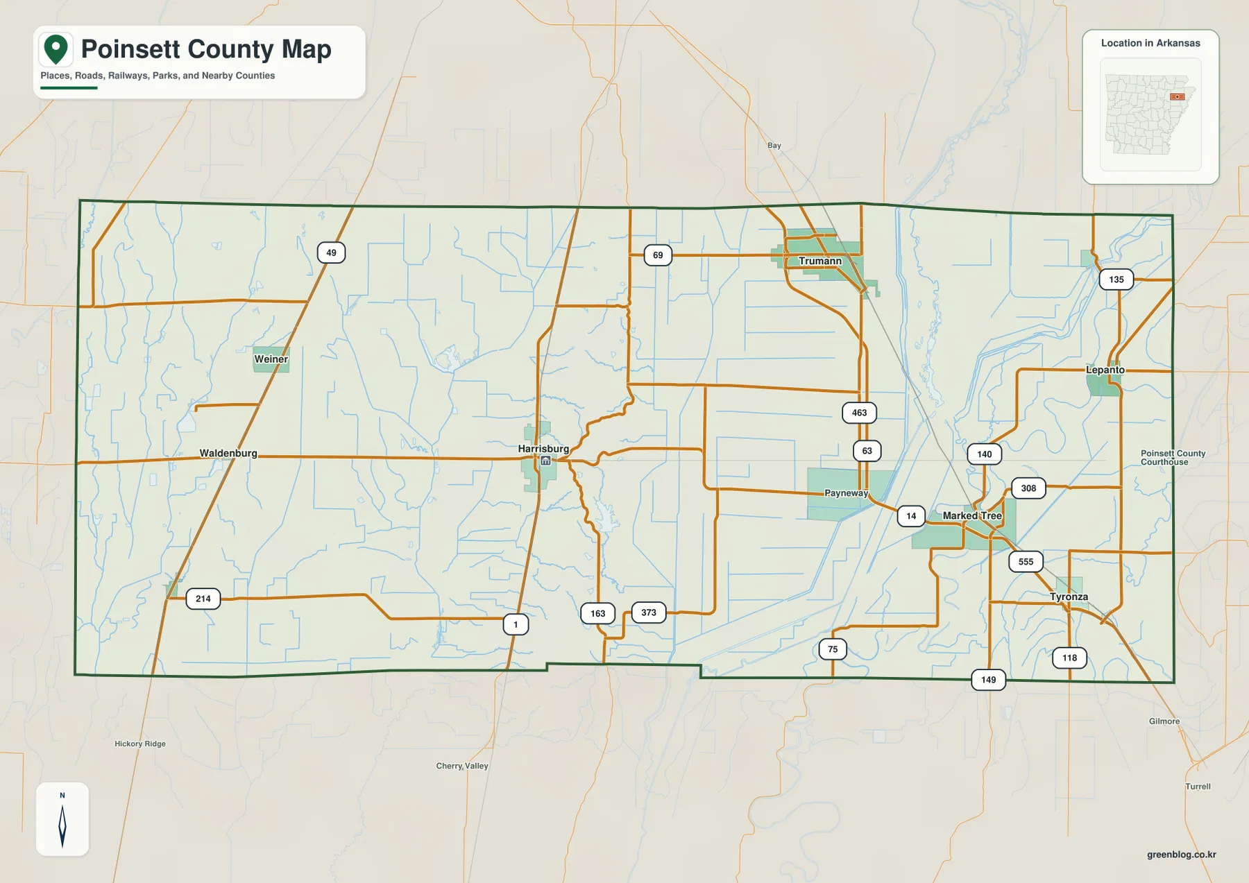
The western side feels different. Weiner lies near Route 49 in the northwest, Waldenburg is farther south, and Route 214 crosses the lower western plain. Smaller roads and drainage channels are widely spread, but there is less concentration than around Trumann or Marked Tree. The ridge near Harrisburg therefore acts as a useful dividing line not only for elevation and water but also for how the road network appears on the page.
The ranked city map clusters four communities in the eastern lowlands
The city map ranks six major communities. Trumann is number 1, Marked Tree 2, Harrisburg 3, Lepanto 4, Weiner 5, and Tyronza 6. These numbers are ranking markers rather than distance measurements. Trumann, Marked Tree, Lepanto, and Tyronza all lie east or southeast of Crowley’s Ridge. Harrisburg sits on the ridge itself, while Weiner is separated on the western plain. That distribution makes the county’s topography visible even before the elevation map is opened.
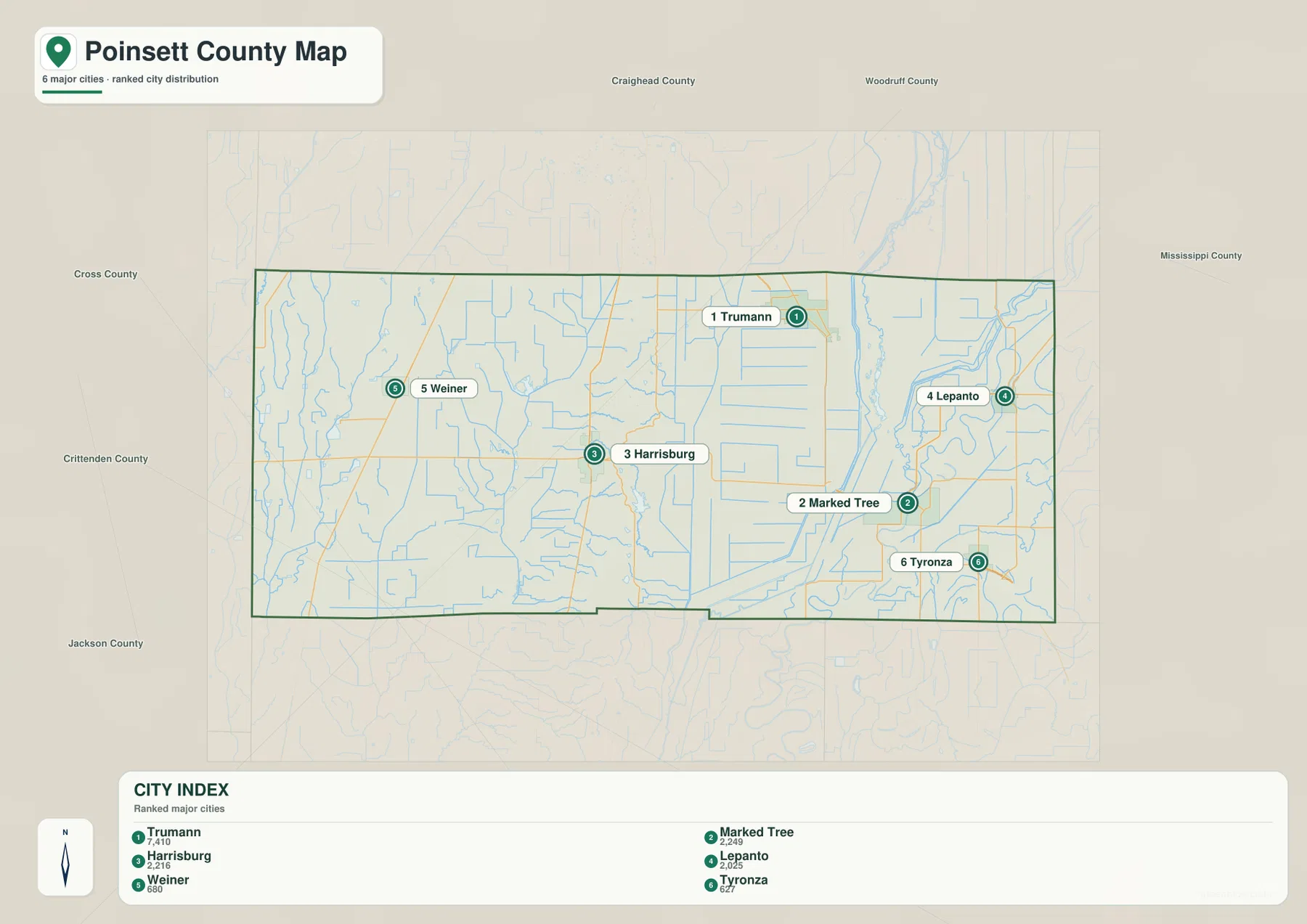
Harrisburg is not ranked first on the supplied city map, but it is the administrative center. Trumann is a larger northeastern road hub, while Marked Tree occupies a low area close to the St. Francis and Tyronza river systems. Lepanto lies farther northeast and Tyronza farther south. Weiner is the only ranked community on the western side of the central ridge. Looking at the city points in relation to the ridge explains more than the ranking alone.
The city legend also includes numeric values beside the community names, but this article does not reinterpret those figures as current population estimates. The supplied map clearly supports the ranking and geographic positions of the six communities. Current population totals should be checked against recent Census data.
Cache and L’Anguille drain the west while St. Francis and Tyronza shape the east
The western water system is anchored by the Cache River and L’Anguille River. The Cache follows the far western side, while the L’Anguille winds through the west-central county. O K Lake and Lake Hogue are labeled in the northwest, and Claypool Reservoir sits farther toward the center. The water pattern is broad and dispersed across a relatively gentle plain, with long natural channels and smaller drainage lines crossing large open areas.
Lake Poinsett is the clearest named water body near the central ridge. County and state-park reference material places Lake Poinsett near Harrisburg on Crowley’s Ridge. On the supplied water map, the lake sits between the L’Anguille system to the west and the St. Francis lowlands to the east, making it a useful middle reference. Small tributaries around the lake are shorter and more tightly packed than the large rivers on either side.
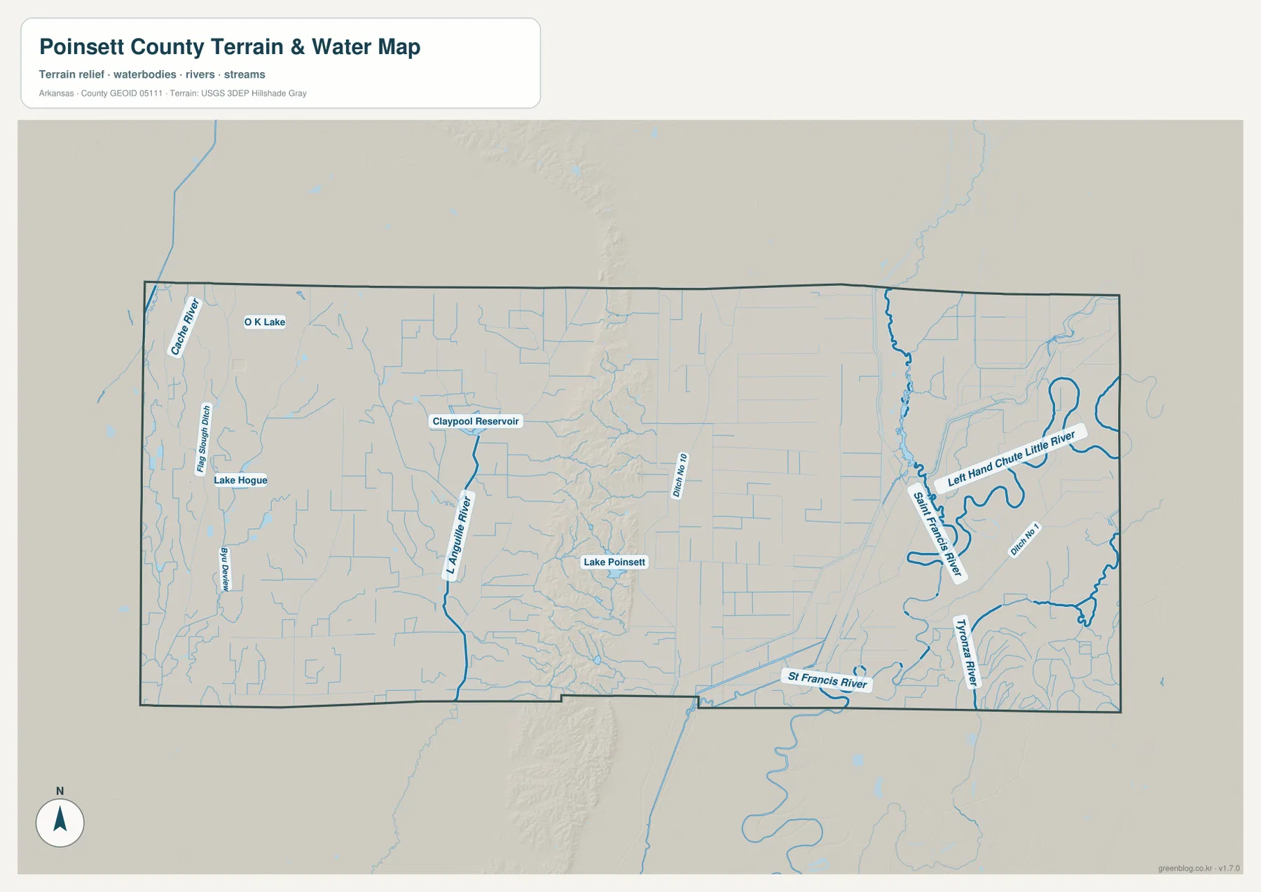
The eastern side has a much more intricate network. The St. Francis River runs north-south through the low country, and the Tyronza River occupies the southeast. Near Marked Tree and Tyronza, large bends and smaller channels sit close together. The Left Hand Chute Little River curves through the northeastern side, while Ditch No 10 and Ditch No 1 add long straight drainage lines to the map. Natural meanders and engineered channels are therefore visible in the same broad floodplain.
This terrain and water map is intended for general geographic reference. It does not provide current river stage, flood risk, drainage operations, fishing rules, property boundaries, or live road access. Current USGS and managing-agency information should be used for flood, river, farm, or safety decisions.
Crowley’s Ridge rises to 136 meters above a county that is otherwise mostly low and flat
The supplied elevation map shows an actual countywide range of about 54 to 136 meters, with a mean near 71 meters. That is roughly 82 meters of relief. Most of the county is green lowland, but a narrow tan and dark-brown band runs almost straight north-south through the middle. That band is Crowley’s Ridge, and it is the defining topographic feature of Poinsett County.
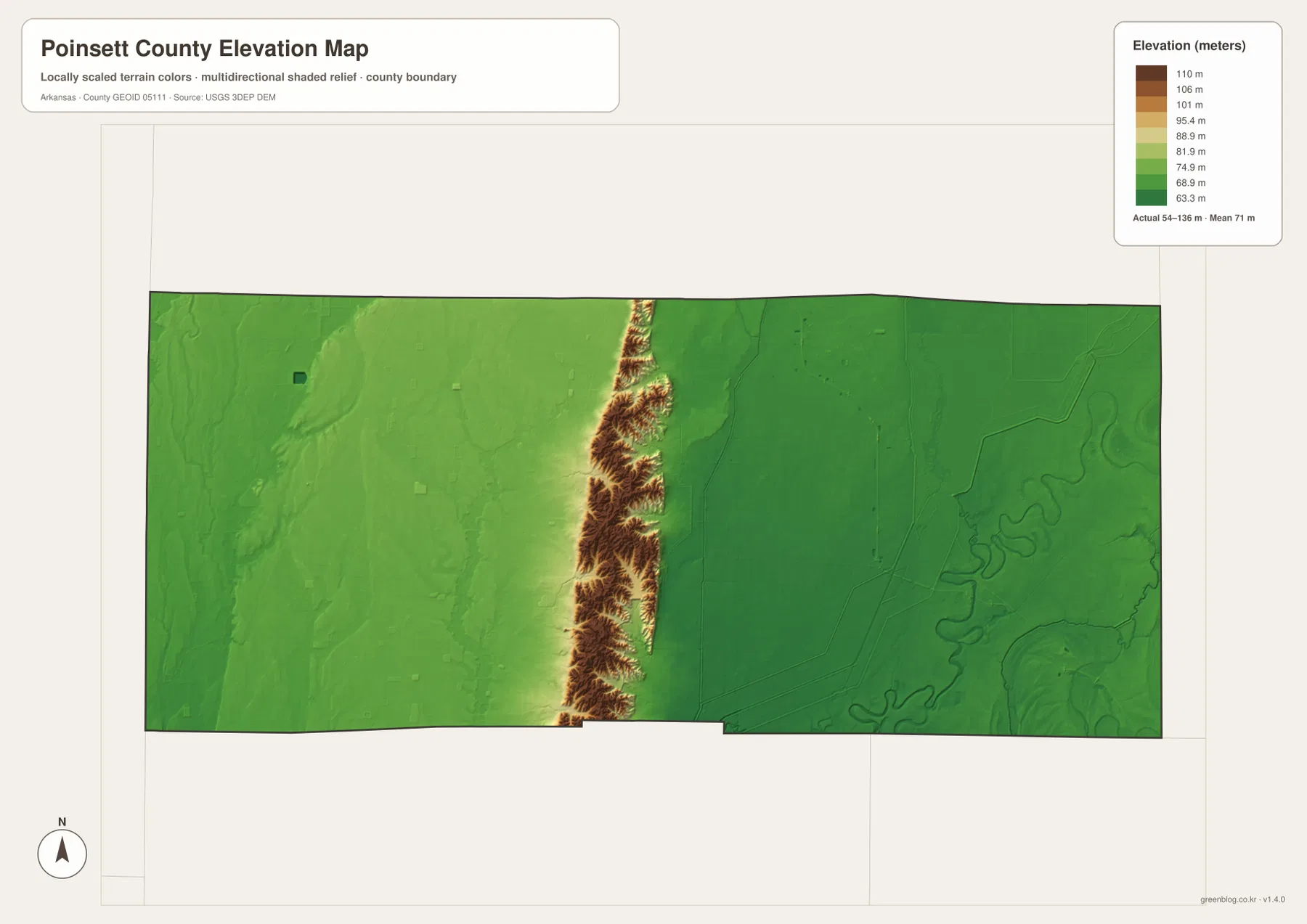
Harrisburg sits directly on this elevated strip, which explains why the city appears isolated between otherwise broad plains. The ridge remains narrow but sends short spurs out to both sides. The western surface drops more gradually into the Cache and L’Anguille country, while parts of the eastern side descend more abruptly toward the St. Francis lowland. This relationship is one of the strongest examples in the map set of a single landform dividing settlement, roads, and drainage.
Trumann, Marked Tree, Lepanto, and Tyronza occupy much lower terrain east of the ridge, with river bends visible in the elevation shading. Weiner and Waldenburg also sit on relatively low ground, though the western plain is generally less deeply incised by the large eastern river channels. The map is useful for county-scale comparison, not exact levee, field, road, or building heights. Detailed elevations require original USGS data or survey-grade measurement.
Crossing from Weiner through Harrisburg to Marked Tree reveals the county in one line
One of the clearest ways to compare the maps is to follow an imaginary west-east line from Weiner through Harrisburg toward Marked Tree. Around Weiner, the terrain is a gentle western plain crossed by the Cache and L’Anguille systems. Approaching Harrisburg, Crowley’s Ridge rises sharply into the center of the county. East of the ridge, the land drops again into the St. Francis and Tyronza lowlands. The sequence is plain, ridge, then lower Delta plain within a relatively short distance.
North and south comparisons add another layer. Trumann is a road-centered northeastern community on flat ground, while the Marked Tree–Tyronza side is more closely surrounded by large meandering rivers and drainage channels. Lepanto is associated with the Left Hand Chute Little River side. Harrisburg remains distinct because it occupies the narrow high ground between those eastern waterways and the western river plain.
The WebP images in the article are optimized for quick page viewing, while the download ZIP contains the same four maps as high-resolution JPG files. Each JPG measures 3638 × 2572 pixels in landscape orientation. Use the general and city maps for Harrisburg, Trumann, Marked Tree, and major roads; compare the water and elevation maps when tracing the Cache River, L’Anguille River, Lake Poinsett, St. Francis River, and the 54–136 meter rise of Crowley’s Ridge.
Frequently Asked Questions
What is the county seat of Poinsett County?
Harrisburg is the county seat. It sits on Crowley’s Ridge near the center of the county, making it the best reference point for comparing the lower St. Francis side to the east with the Cache and L’Anguille plain to the west.
What does Crowley’s Ridge look like on the elevation map?
It appears as a narrow north-south band of much higher tan and brown terrain through the middle of the county. The supplied elevation range is about 54–136 meters with a mean near 71 meters, and Harrisburg lies directly on the ridge.
Do the numbers 1 through 6 on the city map show distance?
No. They are ranking markers used on the supplied city map. Trumann is ranked first, followed by Marked Tree, Harrisburg, Lepanto, Weiner, and Tyronza. Actual road distance and travel time should be checked with a current navigation map.
Map File Information
The ZIP contains the general county map, ranked city map, terrain and water map, and elevation map as high-resolution JPG files for printing or offline reference.
- File Type: ZIP containing 4 JPG files
Related Maps
Sources and references
- Encyclopedia of Arkansas – Poinsett County – county seat and Poinsett County background
- Encyclopedia of Arkansas – Harrisburg – Harrisburg as the county seat on Crowley’s Ridge
- Encyclopedia of Arkansas – Lake Poinsett State Park – Lake Poinsett near Harrisburg and Crowley’s Ridge
- U.S. Census Bureau TIGER/Line Shapefiles – county boundary and road data
- USGS National Hydrography – rivers, streams, lakes, reservoirs, and channels
- USGS 3D Elevation Program – elevation and terrain data
Green Map creates custom-edited map images using open geographic data sources such as geoBoundaries, Natural Earth, OpenStreetMap, and government open data.
These maps are edited visual materials, not raw data files, and are provided for education, documents, presentations, and graphic reference.