Pike County in southwestern Arkansas changes dramatically from the high Ouachita Mountain foothills in the north to lower, gentler country around Murfreesboro and the southern half. Download the four high-resolution JPG maps on this page together in one ZIP file. The package includes the general county map, ranked city map, terrain and water map, and elevation map. Glenwood occupies the northeastern highlands, Daisy and Kirby sit near Lake Greeson, Murfreesboro is farther south, and Delight and Antoine lie toward the southeast. The Little Missouri River enters the rugged northwest, reaches Lake Greeson, and then continues into lower country. The supplied elevation map ranges from about 65 to 538 meters with a mean near 178 meters.
The county is easiest to understand as a transition between two landscapes. The Encyclopedia of Arkansas describes the northern half as rocky foothills of the Ouachita Mountains with valleys between the ridges, while the southern half is much flatter lowland. That contrast is obvious on the supplied elevation map. Brown ridges line the north, but the colors become progressively greener south of Lake Greeson and around Murfreesboro. Murfreesboro, the county seat, provides a useful reference in the lower half of the county for comparing that change with the higher Glenwood-Daisy side.
Table of Contents
The northern roads follow Glenwood, Daisy, and Lake Greeson through hill country
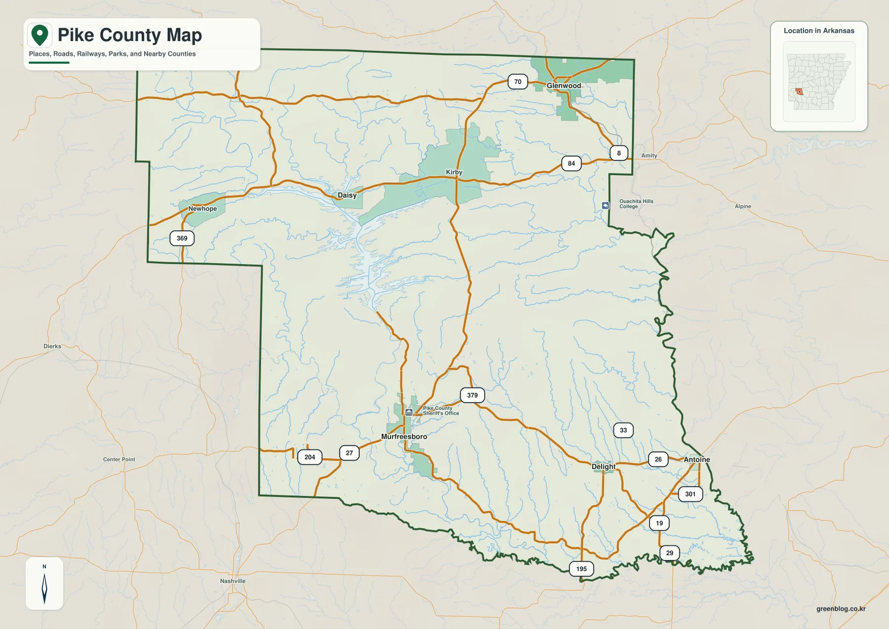
The general county map is easiest to read from north to south. Glenwood is the strongest northeastern reference, with Route 70 near the town and Route 8 continuing along the eastern side. Route 84 runs west through the Kirby area, while Daisy sits near the northern side of Lake Greeson. Newhope is farther west near Route 369. None of these roads form a neat grid because hills, river valleys, and the reservoir repeatedly interrupt straight travel.
South of Lake Greeson, Murfreesboro becomes the main road center. Routes 27 and 204 approach from the west, and Route 379 runs north toward the lake area. Delight lies farther east near Routes 33 and 26, while Antoine is close to the eastern county edge. Routes 301, 19, 29, and 195 appear across the southeastern and southern part of the county. Compared with the north, many of these southern routes cross lower and more open terrain.
The county outline also changes character from one side to another. Several stair-step segments appear along the northwest, and the eastern middle contains an irregular projection. The southern edge includes long bends associated with lower river country. Montgomery and Polk counties are labeled to the north, Clark County to the east, Hot Spring County to the southeast, Nevada and Hempstead counties to the southwest, and Howard County to the west. That surrounding context places Pike County directly along the transition from the Ouachita highlands to the broader southwest Arkansas lowlands.
The ranked city map puts Glenwood first and Murfreesboro second
The city map ranks five major communities. Glenwood is number 1, Murfreesboro 2, Delight 3, Antoine 4, and Daisy 5. These numbers are ranking markers rather than distance measurements. Glenwood lies in the northeastern hill country, Daisy is close to Lake Greeson, Murfreesboro is much farther south, and Delight and Antoine occupy the southeastern side. The five points are spread across noticeably different terrain rather than one continuous settlement corridor.
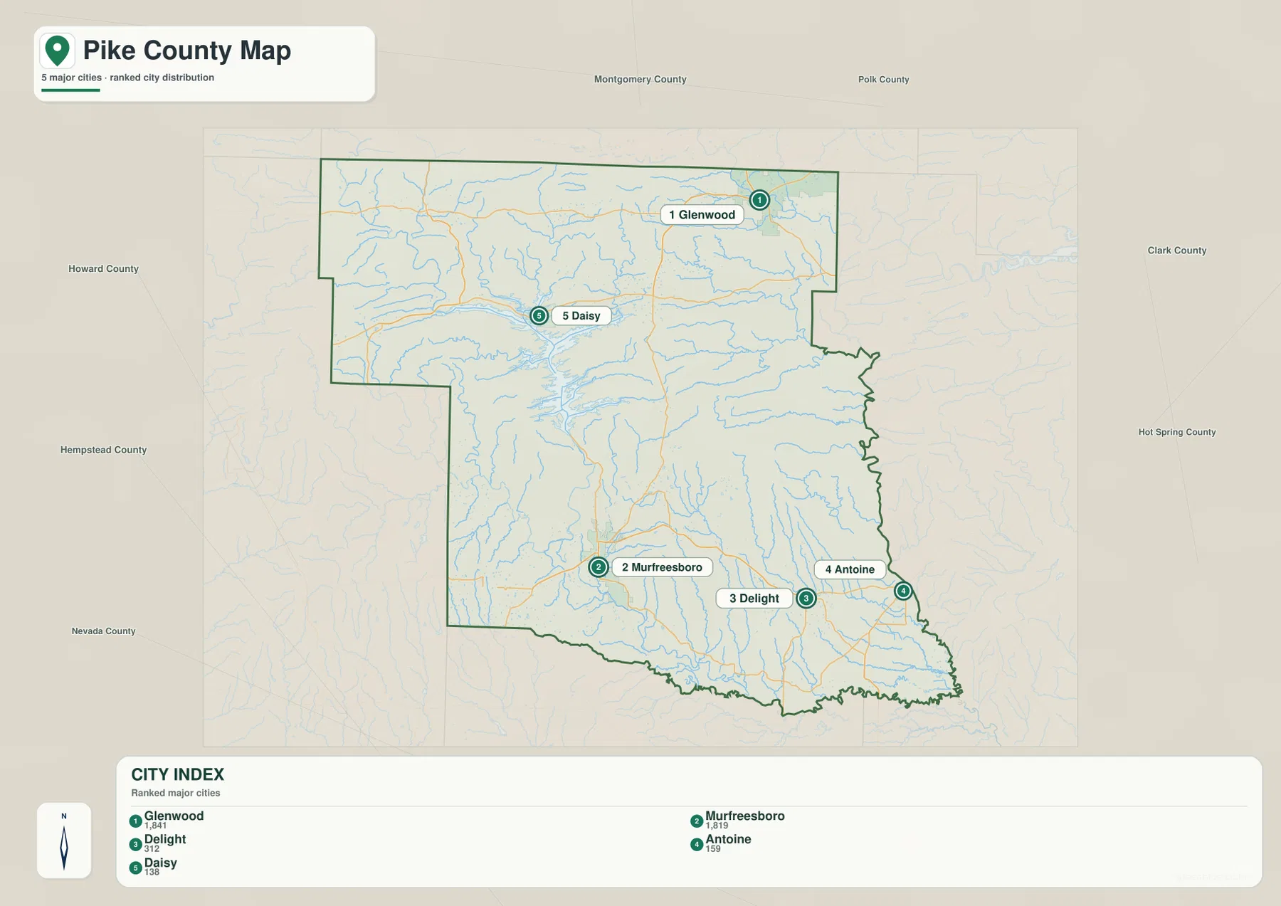
Glenwood ranks first on the supplied city map, but Murfreesboro is the county seat. Murfreesboro sits in lower land not far from the Little Missouri River, while Glenwood is associated with the higher northeastern terrain and the Caddo River. Daisy is useful for locating Lake Greeson and its northern shoreline. Delight and Antoine provide clear references for the southeastern road and river network. Comparing the city points with the water and elevation layers makes the county’s north-south geographic split much more obvious.
The city legend also includes numeric values beside the community names, but this article does not reinterpret those figures as current population estimates. The supplied map clearly supports the ranking and locations of the five communities, so those are the facts used here. Current population totals should be checked against recent Census data.
Little Missouri River links the mountain headwaters with Lake Greeson and lower country
The Little Missouri River is the most important water feature for understanding the county as a whole. It enters Pike County from the mountainous northwest, winds southeast through steep terrain, and reaches Lake Greeson. County reference material describes the same route and notes that the river drops sharply through the Ouachita Mountains before entering the reservoir. Below the lake, the river continues through lower country near Murfreesboro. The river therefore connects the county’s highest terrain, largest lake, and southern lowlands in one continuous geographic story.
Lake Greeson spreads through several flooded valleys in the north-central and western interior. The supplied map also labels Lake Greeson Nursery Pond nearby. Slate Creek and Bear Creek descend through the northern highlands, while Rock Creek occupies another long valley farther northeast. These streams look very different from the lower southern waterways because they run between closely spaced ridges. Arkansas tourism information identifies Lake Greeson as a reservoir on the Little Missouri River near Murfreesboro and Daisy, matching the relationship visible on the map.
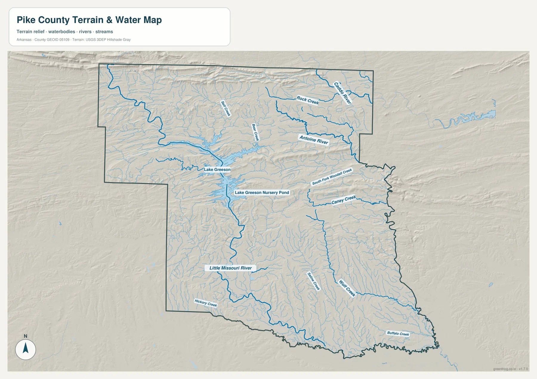
The northeastern corner contains two other important river systems. The Caddo River passes the Glenwood side after leaving the Ouachita Mountains, while the Antoine River begins in the northeastern part of Pike County and flows generally southeast. County reference material places the Antoine River near the eastern boundary before it eventually joins the Little Missouri River. Rock Creek and several smaller tributaries break the high ground between these larger channels. The water map therefore shows the northern county as a set of separate mountain valleys rather than one broad basin.
South of the lake, Caney Creek, Wolf Creek, Hickory Creek, and Buffalo Creek cross lower terrain. South Fork Woodall Creek appears in the east-central interior. These waterways are smaller than the Little Missouri, but they help show how drainage continues through the lower half of the county after the landscape leaves the highest ridges. The map is intended for general geographic reference and does not show current river stage, flood risk, fishing rules, property boundaries, or live road access. Current USGS and managing-agency information should be used for river or outdoor-safety decisions.
Elevation drops from 538 meters in the north to broad lowlands around Murfreesboro
The supplied elevation map shows an actual countywide range of about 65 to 538 meters, with a mean near 178 meters. That is roughly 473 meters of relief. The highest dark-brown terrain is concentrated along the north and northwest, where long ridges occupy the Ouachita foothills. High ground also surrounds parts of the Glenwood and Daisy side. South of Lake Greeson, however, green lower terrain expands quickly around Murfreesboro and continues toward the southeastern boundary.
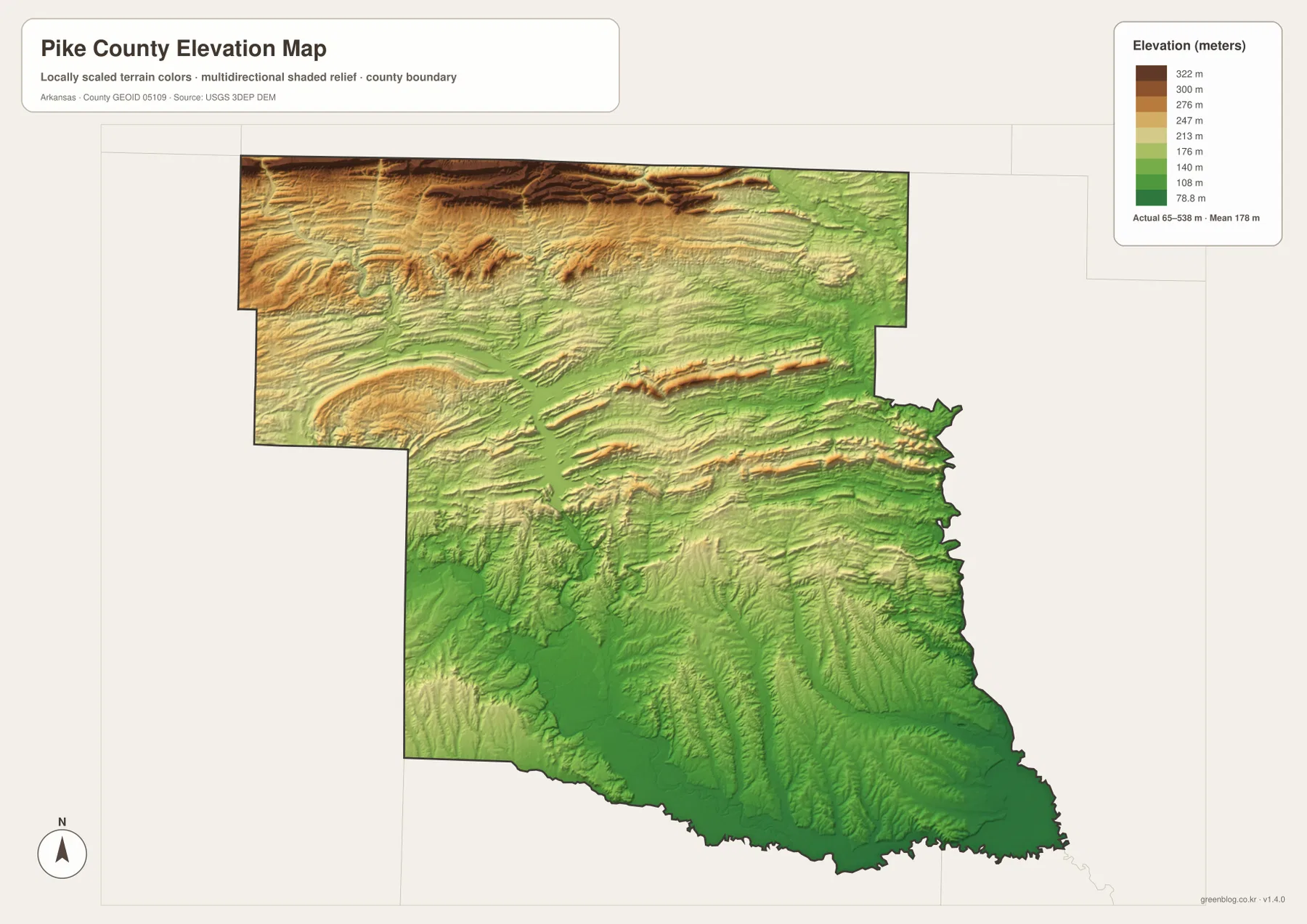
The northern highlands are not one isolated mountain. They are a series of elongated ridges separated by narrow stream valleys. The Caddo River, Rock Creek, Antoine River, and smaller tributaries occupy the lower spaces between those ridges. Lake Greeson fills several of the same valleys, which explains its long branching shoreline. Below the reservoir, the Little Missouri River forms another low corridor heading toward Murfreesboro.
The southern half is lower but not perfectly flat. Shallow valleys follow Caney Creek, Wolf Creek, Hickory Creek, and Buffalo Creek, while low rolling ground rises between them. Moving north toward the Antoine River and Lake Greeson side brings more tan and brown relief back into view. The elevation map is therefore most useful first for seeing the major north-south drop and then for comparing how individual streams cut through that transition. Exact parcel, road, bridge, or building elevations require original USGS data or survey-grade measurement.
Follow Lake Greeson south to Murfreesboro to see the county’s clearest transition
A practical way to use all four maps is to begin around Lake Greeson and then move south toward Murfreesboro. Daisy, Kirby, and Glenwood sit in or near higher northern terrain where roads bend around ridges and streams. The reservoir occupies deep valleys in the middle of that landscape. Moving south along the Little Missouri River brings a steady drop in elevation, and the Murfreesboro area opens into much gentler terrain. Roads, water, settlement, and elevation all change in the same general direction.
The eastern side offers another comparison. From Kirby toward the Antoine River, Rock Creek, Bear Creek, and South Fork Woodall Creek divide the hill country into multiple valleys. Farther south around Delight and Antoine, the terrain becomes lower and creek corridors stretch through broader land. Looking west toward Newhope brings the map back toward the higher Little Missouri headwater side. Pike County is therefore more than a generic rural county: it is a compact transition from rugged Ouachita foothills through a large reservoir to the flatter land around Murfreesboro.
The WebP images in the article are optimized for quick page viewing, while the download ZIP contains the same four maps as high-resolution JPG files. Each JPG measures 3638 × 2572 pixels in landscape orientation. Use the general map for Glenwood, Murfreesboro, Delight, roads, and boundaries; the ranked city map for the five major communities; the terrain and water map for the Little Missouri River, Lake Greeson, Caddo River, Antoine River, and creeks; and the elevation map for comparing the county’s 65–538 meter relief.
Frequently Asked Questions
Is Glenwood or Murfreesboro the county seat of Pike County?
Murfreesboro is the county seat. Glenwood is ranked first on the supplied city map and Murfreesboro second, but the ranking does not determine the administrative center. The general map also labels the Pike County Sheriff’s Office in the Murfreesboro area.
How does Lake Greeson connect with the Little Missouri River?
The Little Missouri River enters Pike County through the rugged northwest and is impounded by Narrows Dam to form Lake Greeson. Below the reservoir, the river continues through lower terrain near Murfreesboro. Comparing the terrain, water, and elevation maps makes this mountain-to-lowland transition especially clear.
Where is the highest terrain in Pike County?
The supplied elevation map shows the highest terrain across the north and northwest in the Ouachita foothills. The actual countywide range is about 65–538 meters with a mean near 178 meters. Terrain drops considerably south of Lake Greeson toward Murfreesboro, Delight, and the southeastern county.
Map File Information
The ZIP contains the general county map, ranked city map, terrain and water map, and elevation map as high-resolution JPG files for printing or offline reference.
- File Type: ZIP containing 4 JPG files
Related Maps
Sources and references
- Encyclopedia of Arkansas – Pike County – Murfreesboro county seat, Ouachita foothills, southern lowlands, and major rivers
- Encyclopedia of Arkansas – Murfreesboro – Murfreesboro county-seat and Little Missouri River/Lake Greeson setting
- Arkansas.com – Lake Greeson – Lake Greeson and its location near Murfreesboro
- U.S. Census Bureau TIGER/Line Shapefiles – county boundary and road data
- USGS National Hydrography – rivers, streams, lakes, and hydrography data
- USGS 3D Elevation Program – elevation and terrain data
Green Map creates custom-edited map images using open geographic data sources such as geoBoundaries, Natural Earth, OpenStreetMap, and government open data.
These maps are edited visual materials, not raw data files, and are provided for education, documents, presentations, and graphic reference.