Phillips County in eastern Arkansas follows the Mississippi River through a broad Delta landscape, but one narrow area breaks the pattern dramatically: high terrain rises just north and northwest of Helena-West Helena while most of the county remains very low and flat. Download the four high-resolution JPG maps on this page together in one ZIP file. The package includes the general county map, ranked city map, terrain and water map, and elevation map. Helena-West Helena sits on the eastern river edge, Marvell and Lexa are farther west and north, and Elaine and Lake View lie in the southern half. The supplied elevation map ranges from about 39 to 130 meters with a mean near 54 meters.
Helena-West Helena is the county seat and the best place to begin reading the maps. The Encyclopedia of Arkansas places the city on the Mississippi River and identifies it as the seat of Phillips County. On the supplied road map, Helena-West Helena is the largest eastern settlement, with Routes 49 and 242 nearby and road connections leading west toward Marvell, north toward Lexa, and south toward Elaine. The unusual combination of river, city, and nearby high ground makes this corner especially important for understanding the county.
Table of Contents
Use Helena-West Helena to separate the Marvell, Lexa, and Elaine road directions
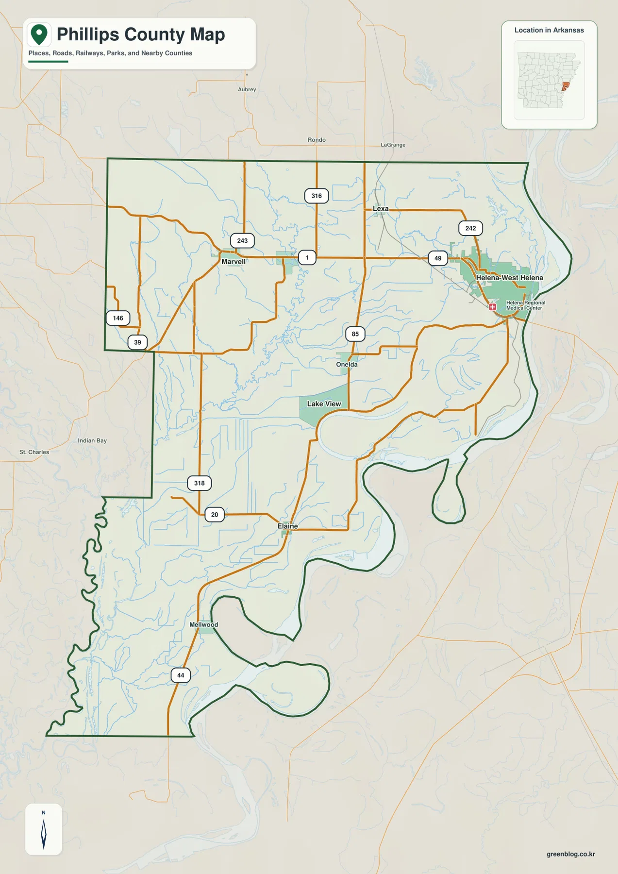
The general map is busiest around Helena-West Helena. Route 49 provides a strong westward reference, and Route 242 continues across the northeastern side. Route 1 reaches toward Marvell, while Route 316 helps locate the Lexa side to the northwest. Helena Regional Medical Center is also labeled in the city area, providing another visible reference point near the eastern edge.
Marvell sits in the northwestern plain near Routes 243 and 1. Farther west, Routes 39 and 146 run close to the county boundary. Moving south, Route 85 reaches the Oneida and Lake View side, while Routes 318 and 20 cross toward Elaine. Route 44 appears near Mellwood in the far south. Compared with the dense road pattern around Helena-West Helena, the southern half has longer straight routes separated by broad fields and drainage channels.
The eastern county boundary follows large bends of the Mississippi River, producing a very different outline from the straighter western side. The St. Francis River approaches the Mississippi near the northeastern corner, and the lower eastern boundary continues through additional large river curves. Monroe and Desha counties lie to the west, with Arkansas County farther southwest. Comparing the general and water maps makes the river-shaped eastern edge especially easy to recognize.
The ranked city map separates the river city from western and southern communities
The city map ranks five major communities. Helena-West Helena is number 1, Marvell 2, Elaine 3, Lake View 4, and Lexa 5. These numbers are ranking markers rather than distance measurements. Helena-West Helena stands alone on the eastern river side, Marvell and Lexa occupy the northwestern half, and Elaine and Lake View are farther south. The pattern reflects a county whose settlements are spread across several parts of a large Delta plain.
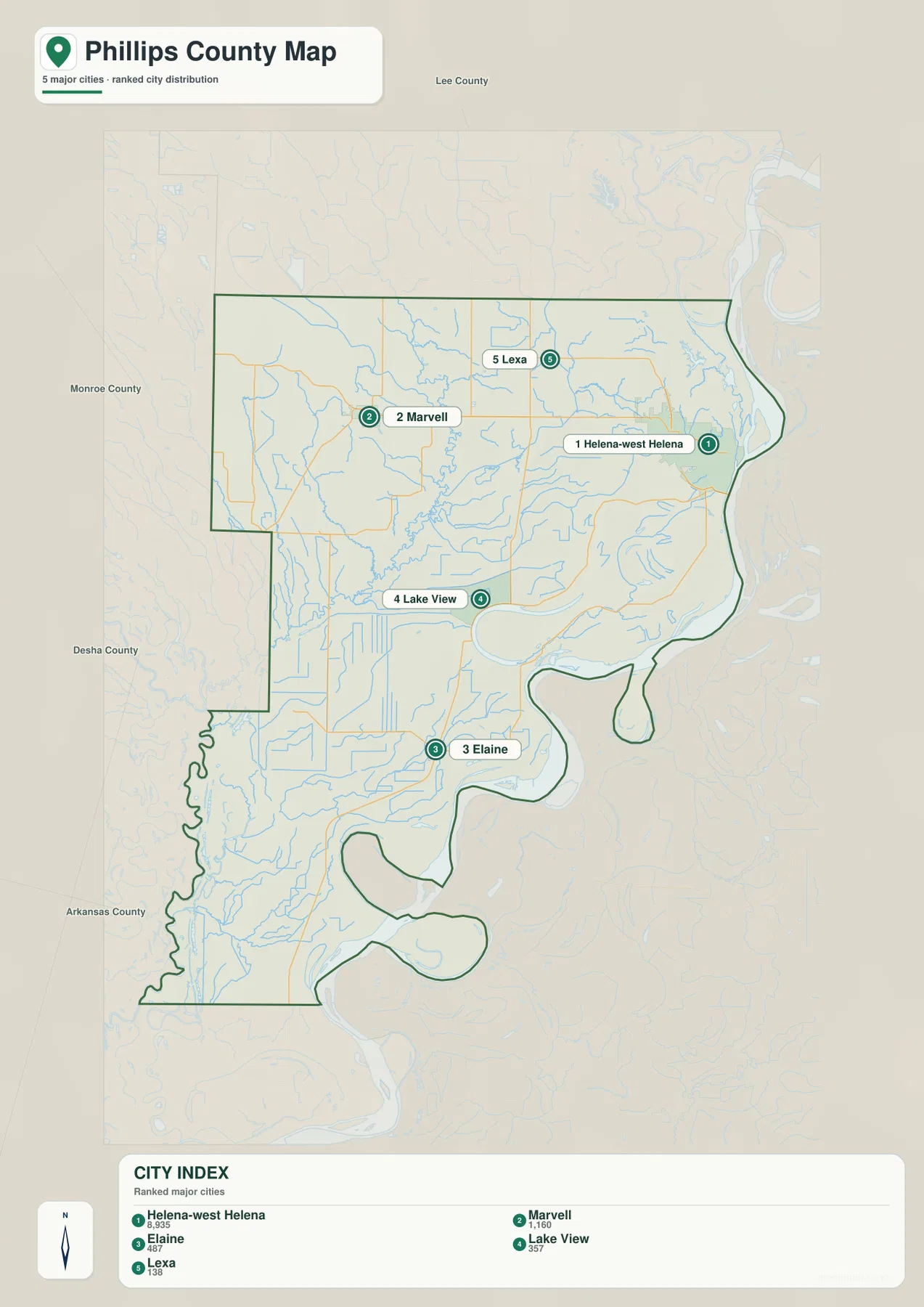
Helena-West Helena is both the top-ranked community on the supplied map and the county seat. Marvell serves as a useful northwestern reference, while Elaine and Lake View help locate the southern half. Lexa sits closer to Helena-West Helena but remains west of the main Mississippi River corridor. Comparing these city points with the water and elevation layers shows that each community occupies a different mix of river plain, drainage country, or nearby higher ground.
The city legend also displays numeric values beside the community names, but this article does not reinterpret those figures as current population estimates. The supplied map clearly supports the ranking and geographic positions of the five communities, so those are the facts used here. Current population totals should be checked against recent Census data.
Mississippi River and Big Creek provide the strongest water references
The Mississippi River dominates the eastern edge of the terrain and water map. Helena-West Helena sits directly beside it, while the St. Francis River approaches from the north. Storm Creek Lake, Porter Lake, and Brushy Lake are labeled near the northeastern river corridor. The large main river, smaller lakes, and curved secondary water features create a much more complex landscape than the general road map suggests.
Big Creek is the clearest interior waterway across the north-central county. Crooked Creek joins from the west, and Lick Creek approaches from the east. Big Creek then winds south through the low interior. Beaver Bayou Ditch follows a much straighter line farther east, creating a useful contrast between a naturally meandering creek and engineered-looking drainage lines across the flat Delta plain.
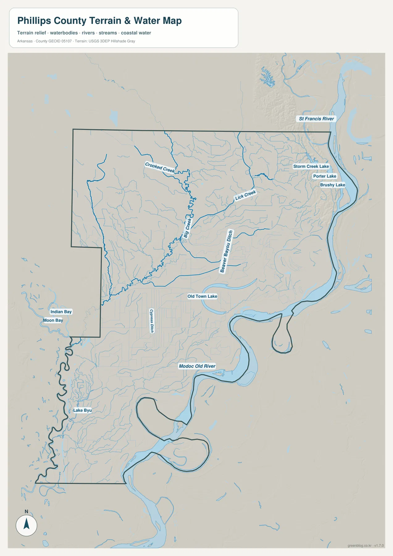
Farther south, Big Cypress Creek becomes a stronger reference, with long straight drainage lines extending through the surrounding lowland. Old Town Lake appears in the central-southern section, and Modoc Old River is labeled closer to a large eastern river bend. Indian Bay and Moon Bay lie in the western projection, while Lake Byu appears farther southwest. Phillips County is therefore defined by a mixture of a major river, smaller creeks, bayous, ditches, old channels, and isolated lakes.
This terrain and water map is intended for general geographic reference. It does not provide current Mississippi River or St. Francis River stage, flood risk, levee condition, agricultural drainage operations, property boundaries, or live road access. Current USGS and managing-agency information should be used for flood, river, or field-safety decisions.
Elevation ranges from 39 to 130 meters, with one striking high ridge near Helena-West Helena
The supplied elevation map shows an actual countywide range of about 39 to 130 meters, with a mean near 54 meters. That is roughly 91 meters of relief. Most of Phillips County is very low Delta plain, shown in green, but a narrow belt of tan and dark-brown high ground rises north and northwest of Helena-West Helena. The contrast is unusually sharp for a county that is otherwise almost entirely flat.
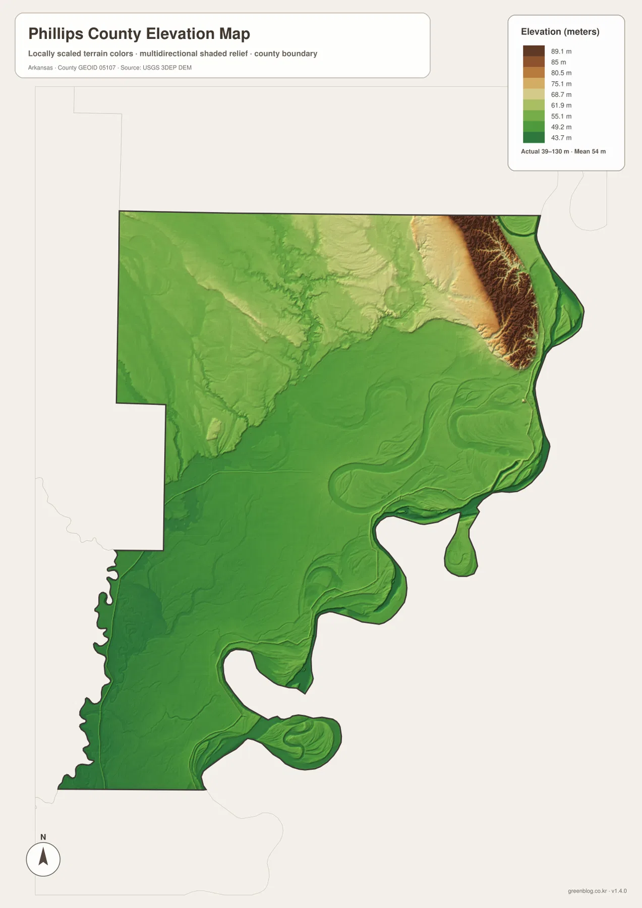
The high ridge follows the northeastern side for a relatively short distance and then drops quickly toward the surrounding plain. West of it, rolling terrain fades into lower ground around Marvell and the central county. Elaine, Lake View, and most of the southern half remain very low. The same places that look crowded with creeks and ditches on the water map appear as broad green lowland on the elevation layer.
The large Mississippi River bends and old channels also create subtle elevation patterns along the eastern and southern edge. This map alone does not justify labeling every raised strip as a natural levee or assigning a specific geomorphic name. What the supplied data clearly shows is the low average elevation and the exceptional higher ridge near Helena-West Helena. Exact levee, road, field, or building elevations require original USGS data or survey-grade measurement.
Compare Marvell and Elaine from Helena-West Helena to see the county change
A practical way to use all four maps is to begin at Helena-West Helena and compare the westward direction toward Marvell with the southward direction toward Elaine. Toward Marvell, Routes 1 and 243 cross a broad low plain cut by Big Creek and smaller waterways. The high northeastern ridge quickly gives way to lower terrain, which is obvious on the elevation map.
The Elaine direction moves into an even flatter southern landscape. Routes 318 and 20 cross long drainage corridors, while Big Cypress Creek, Old Town Lake, and Modoc Old River become important water references. Large Mississippi River bends continue to shape the eastern boundary. Looking at the river city, the northwestern plain, and the southern drainage country together gives a much clearer picture of Phillips County than any one map by itself.
The WebP images in the article are optimized for quick page viewing, while the download ZIP contains the same four maps as high-resolution JPG files. Each JPG measures 2572 × 3638 pixels in portrait orientation. Use the general map for Helena-West Helena, Marvell, Elaine, roads, and boundaries; the ranked city map for the five major communities; the terrain and water map for the Mississippi River, Big Creek, Big Cypress Creek, and named lakes; and the elevation map for comparing the county’s 39–130 meter relief.
Frequently Asked Questions
What is the county seat of Phillips County?
Helena-West Helena is the county seat. It sits directly on the Mississippi River and is the largest settlement shown on the supplied map. Starting there makes it easier to locate Marvell, Lexa, Elaine, and the major river boundary.
Do the numbers 1 through 5 on the city map show distance?
No. They are ranking markers used on the supplied city map. Helena-West Helena is ranked first, followed by Marvell, Elaine, Lake View, and Lexa. Actual driving distance and travel time should be checked with a current road or navigation map.
Where is the highest terrain in Phillips County?
The supplied elevation map shows the highest ground in a narrow ridge north and northwest of Helena-West Helena. The actual countywide range is about 39–130 meters with a mean near 54 meters. Most of the central and southern county is much lower and flatter.
Map File Information
The ZIP contains the general county map, ranked city map, terrain and water map, and elevation map as high-resolution JPG files for printing or offline reference.
- File Type: ZIP containing 4 JPG files
Related Maps
Sources and references
- Encyclopedia of Arkansas – Phillips County – Helena-West Helena county-seat and county background
- Encyclopedia of Arkansas – Helena-West Helena – Mississippi River location and Helena-West Helena background
- U.S. Census Bureau TIGER/Line Shapefiles – county boundary and road data
- USGS National Hydrography – rivers, creeks, ditches, lakes, and hydrography data
- USGS 3D Elevation Program – elevation and terrain data
Green Map creates custom-edited map images using open geographic data sources such as geoBoundaries, Natural Earth, OpenStreetMap, and government open data.
These maps are edited visual materials, not raw data files, and are provided for education, documents, presentations, and graphic reference.