Logan County in western Arkansas stretches from the Arkansas River on the north to high mountain terrain in the south, giving the county a much larger elevation range than many surrounding areas. It is also unusual because it has two county seats: Paris in the northern district and Booneville in the southern district. Magazine, Subiaco, Scranton, and Caulksville fill in the long space between and around those two centers. This page shows communities, roads, the Arkansas River, Petit Jean River, mountain streams, reservoirs, and an actual elevation range of about 102 to 837 meters. The same four maps are available as high-resolution JPG files in one downloadable ZIP.
The two-seat arrangement is a useful way to understand the county map. The Encyclopedia of Arkansas identifies Paris as the seat of the Northern District and Booneville as the seat of the Southern District. Paris sits in the north-central portion close to Route 22 and the Arkansas River Valley, while Booneville is much farther southwest near the Petit Jean River side. The broad separation between them includes rolling uplands and the Mount Magazine area, so Logan County does not read like a county organized around one single urban center.
Table of Contents
Paris and Booneville anchor two distinct road networks
Paris is the strongest road reference in the northern half. Route 22 runs east-west through the Paris area, linking toward Subiaco and New Blaine on the east and toward Caulksville and Ratcliff on the west. Route 197 appears near Subiaco, while Routes 288 and 393 serve the Scranton side farther northeast. The northern county boundary bends repeatedly because it follows the Arkansas River corridor rather than a simple straight survey line.
Booneville forms a separate road center in the southwest. Route 10 runs east toward Magazine, Route 116 reaches northwest, and Route 217 continues south. Route 60 crosses the western side, with Routes 23 and 71 appearing near the southwestern boundary. Route 109 links the Booneville-Magazine area northward toward the Paris side. Following these two road centers separately is much easier than trying to read Logan County as one continuous grid.
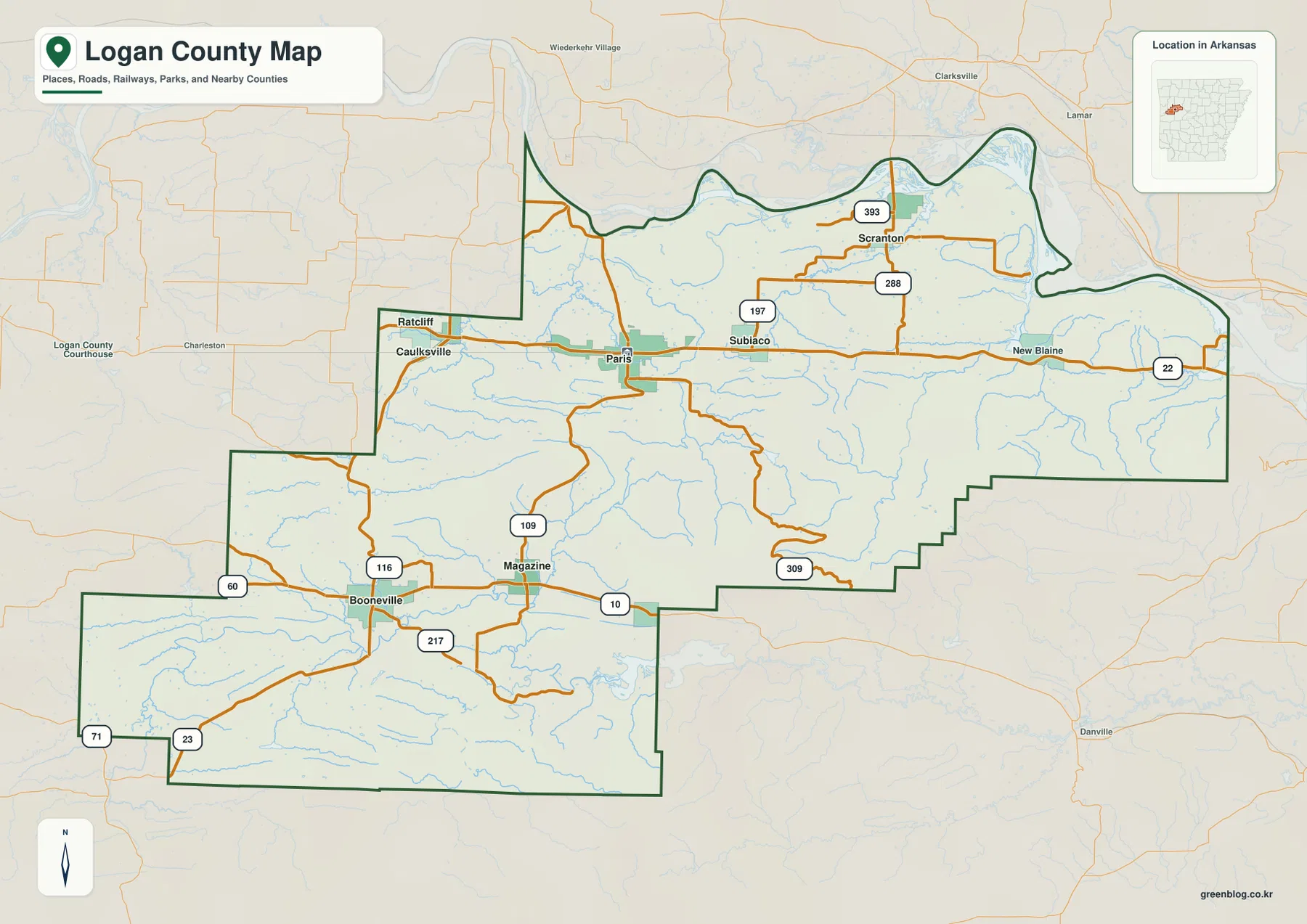
The county outline reinforces the same north-south difference. Long step-like boundaries mark much of the south, while the north curves around the Arkansas River. The Booneville side extends farther southwest, and a broad central-southern block carries the county into much higher terrain. Franklin, Johnson, Pope, Yell, Scott, Sebastian, and Crawford counties are labeled around the map, placing Logan County between the Arkansas River Valley and the rugged highlands of western Arkansas.
The ranked city map puts Booneville first and Paris second
The city map ranks six major communities. Booneville is number 1, Paris 2, Magazine 3, Subiaco 4, Scranton 5, and Caulksville 6. These numbers are ranking markers, not distance labels. Booneville and Magazine occupy the southern portion, Paris and Subiaco are grouped farther north along the Route 22 corridor, Scranton lies in the northeast, and Caulksville sits to the northwest. The pattern makes the county’s split between northern and southern settlement centers easy to see.
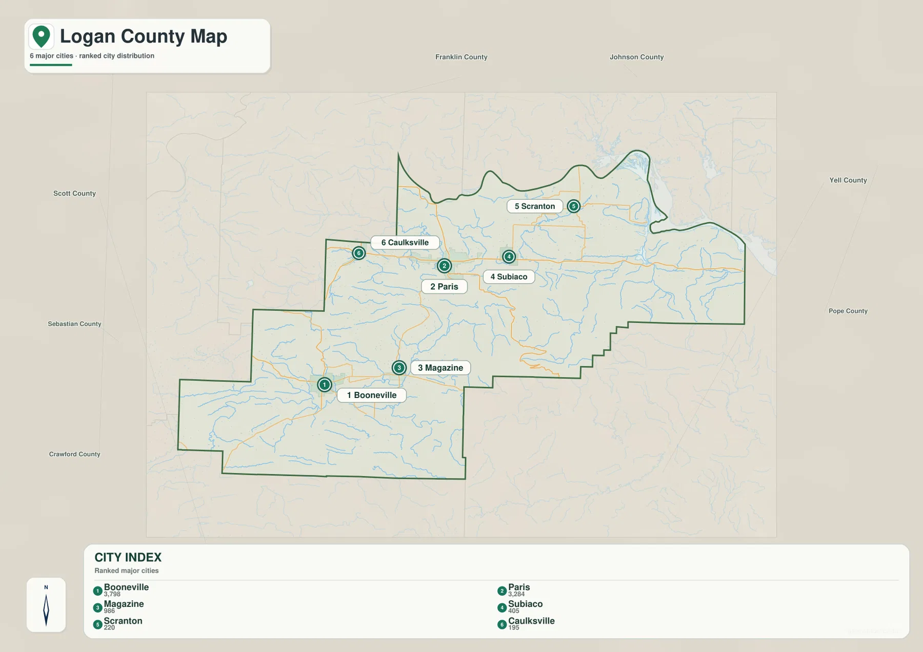
The city distribution also helps explain why two county seats developed. Paris serves the northern district near the Arkansas River Valley, while Booneville serves the more distant southern district. Historical county information notes that Logan County was divided into two judicial districts in 1901, with a courthouse and county seat in each. On the modern map, the distance between the two centers and the mountain terrain between parts of the county make that arrangement geographically understandable.
The legend includes numeric values next to the city names, but this article does not treat those figures as current population estimates. The supplied map clearly supports the ranking and geographic positions of the six communities, so those are the facts used here. Current population figures should be checked against recent Census data.
Arkansas River lowlands and the Petit Jean River frame a complex mountain drainage
The Arkansas River is the dominant water feature along the northern edge of the terrain and water map. It bends through the upper boundary, especially around the Scranton side. Short Mountain Creek and Cane Creek descend toward that northern river corridor, while Sixmile Creek is labeled west of Paris. Paris Reservoir and Subiaco Reservoir provide two useful interior landmarks close to the northern settlement belt.
The Petit Jean River is the major waterway in the southwestern and south-central part of the county. It winds through the broad valley below Booneville and Magazine and gathers many smaller streams from the surrounding ridges. Sugar Creek follows the southern side, while Big Shoal Creek cuts through the east-central mountain country. The contrast is clear: the Arkansas River forms a broad northern boundary, while the Petit Jean River occupies a long interior valley between higher ridges.
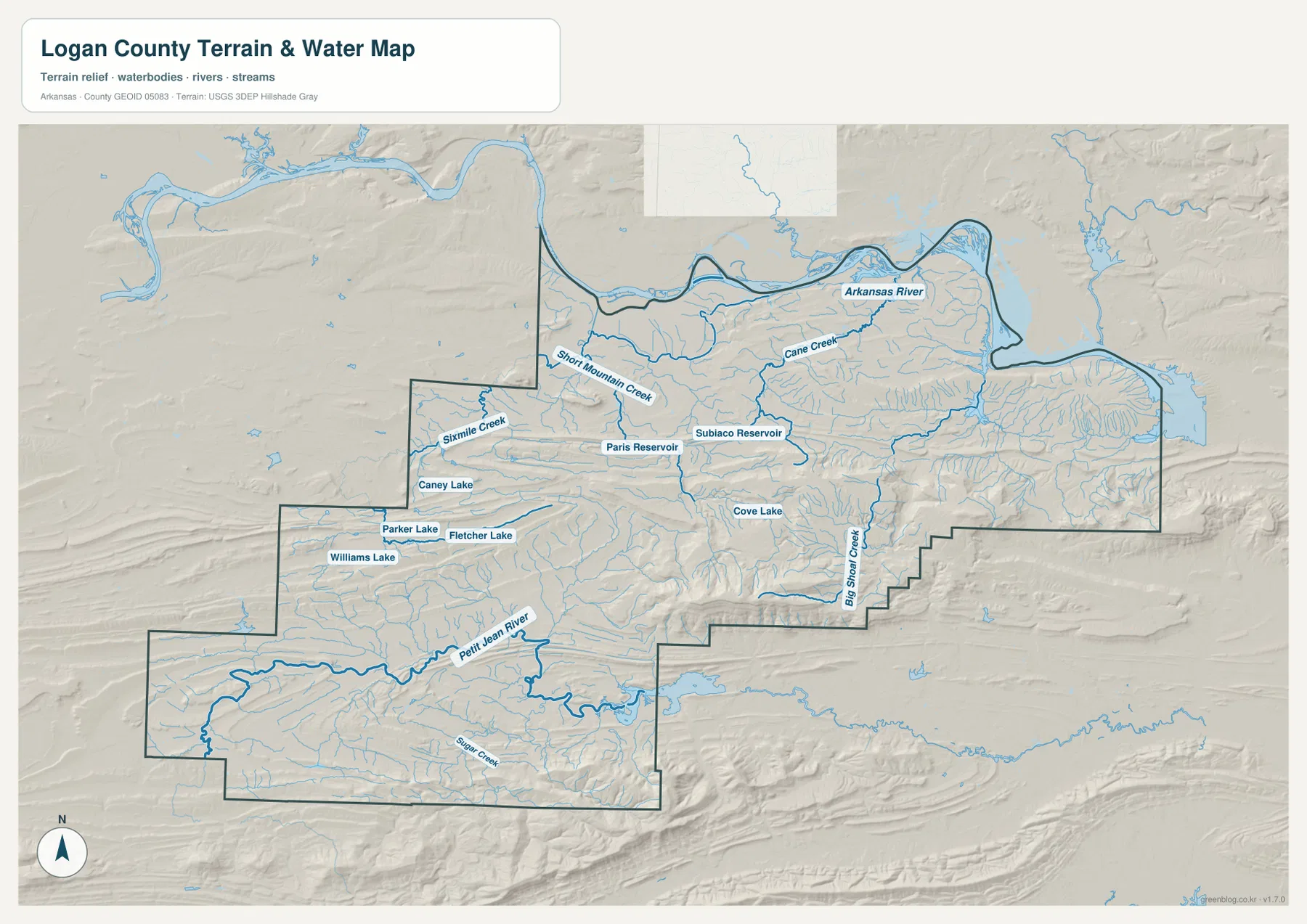
Several smaller lakes and reservoirs are scattered through the western and central interior. Caney Lake appears south of the Caulksville side, Parker Lake and Fletcher Lake lie northeast of Booneville, and Williams Lake is farther west. Cove Lake sits close to the higher Mount Magazine terrain. Logan County therefore has no single inland lake dominating the map; instead, the water pattern changes from a major boundary river to mountain creeks, valley rivers, and small reservoirs at different elevations.
This terrain and water map is intended for general geographic reference. It does not show current Arkansas River or Petit Jean River stage, flood risk, fishing rules, property boundaries, or live road access. Mountain streams can also change quickly after heavy rain. For recreation, flooding, or safety decisions, use current USGS information and guidance from the agency responsible for the specific waterway.
Elevation ranges from about 102 to 837 meters, with Mount Magazine dominating the south-central highlands
The supplied elevation map shows an actual countywide range of about 102 to 837 meters, with a mean near 208 meters. That is roughly 735 meters of relief. Green lowlands dominate the Arkansas River side and much of the Booneville-Petit Jean River valley, while dark brown mountain terrain rises abruptly in the south-central county. That high block corresponds to the Mount Magazine area. Arkansas State Parks identifies Mount Magazine as the highest point in the state, which explains why the county’s elevation map contains such an unusually strong local maximum.
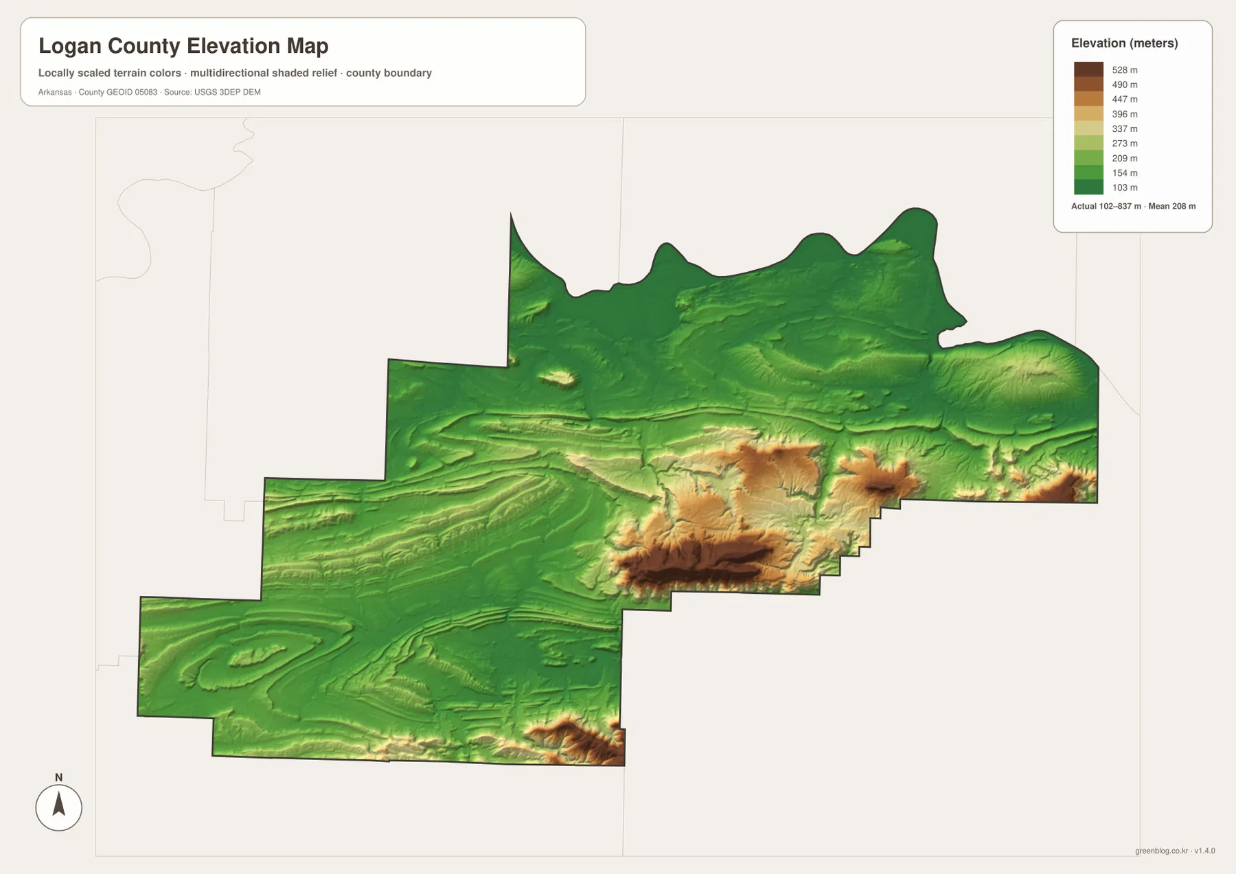
The Mount Magazine area is not shown as one tiny summit. A long, broad ridge appears in dark brown, with steep side valleys dropping into lower green and yellow terrain. Big Shoal Creek and several smaller streams occupy some of those lower corridors. High ridges also continue toward the eastern and southeastern county edge, but the strongest contrast lies between the south-central highlands and the lower Paris-Subiaco corridor to the north.
The Booneville and Magazine side is lower than Mount Magazine but still far from uniformly flat. Rolling ridges surround the Petit Jean River valley, and additional uplands appear along the southwestern and southern boundaries. The Arkansas River side is much lower and gentler. As a result, Logan County brings river lowland, rolling valley country, and some of Arkansas’s highest terrain into one county boundary. The elevation image is intended for county-scale comparison rather than survey-grade measurement, so exact parcel, road, or building heights require original elevation data or a professional survey.
Follow the change south from Paris toward Mount Magazine and Booneville
A practical way to compare the four maps is to begin at Paris and move south. Around Paris, roads and settlements occupy relatively low Arkansas River Valley terrain. Farther south, elevation rises rapidly toward the Mount Magazine area, where the elevation colors shift from green to tan and dark brown. Route 309 appears on the general map along the highland side, while the water map changes from reservoirs and broad northern drainage to narrow mountain creeks and deeply cut valleys.
Booneville provides a second comparison. The southern county seat sits in the broader Petit Jean River valley, with Magazine nearby and higher ridges enclosing the valley on several sides. Paris and Booneville perform similar county-seat roles but occupy very different road and terrain settings. Looking at both cities together with Mount Magazine helps explain why Logan County feels like several geographic zones connected within one long boundary rather than a single uniform landscape.
High-resolution JPG files for both county seats, rivers, and mountain detail
The WebP images in the article are optimized for quick page viewing. The download ZIP contains the same four maps as high-resolution JPG files, each measuring 3638 × 2572 pixels in landscape orientation. Use the general map for Paris, Booneville, surrounding communities, and roads; the ranked city map for the six major places; the terrain and water map for the Arkansas River, Petit Jean River, mountain creeks, lakes, and reservoirs; and the elevation map for the dramatic rise toward Mount Magazine.
The JPG files are suitable for classroom reference, presentations, trip preparation, personal printing, and general orientation. They should not replace legal boundary records, parcel surveys, flood studies, hiking-safety information, engineering plans, or live navigation. When exact or current information is required, consult Census TIGER/Line boundaries, USGS hydrography, USGS elevation data, and Arkansas State Parks for the specific topic.
Frequently Asked Questions
Why does Logan County have two county seats?
Logan County is divided into northern and southern judicial districts. Paris serves as the county seat of the Northern District, while Booneville serves the Southern District. County history sources date the two-district arrangement to 1901. The modern maps also show how far apart the two cities are and how much rural and mountain terrain lies between different parts of the county.
Do the numbers 1 through 6 on the city map show distances?
No. They are ranking markers used on the supplied city map. Booneville is ranked first, Paris second, Magazine third, Subiaco fourth, Scranton fifth, and Caulksville sixth. Actual travel distance and time should be checked with a current road or navigation map.
How much elevation change is shown across Logan County?
The supplied elevation map shows an actual range of about 102–837 meters with a mean near 208 meters. The Arkansas River side is relatively low, while the Mount Magazine area rises dramatically in the south-central county. That produces roughly 735 meters of relief across the map.
Map File Information
The ZIP contains the general county map, ranked city map, terrain and water map, and elevation map as high-resolution JPG files for printing or offline reference.
- File Type: ZIP containing 4 JPG files
Related Maps
Sources and references
- Encyclopedia of Arkansas – Logan County – county history, Paris and Booneville county seats, and regional background
- Arkansas State Parks – Mount Magazine Maps – official Mount Magazine location and access information
- U.S. Census Bureau TIGER/Line Shapefiles – county boundary and road data
- USGS National Hydrography – rivers, streams, lakes, and hydrography data
- USGS 3D Elevation Program – elevation and terrain data
Green Map creates custom-edited map images using open geographic data sources such as geoBoundaries, Natural Earth, OpenStreetMap, and government open data.
These maps are edited visual materials, not raw data files, and are provided for education, documents, presentations, and graphic reference.