Lee County in eastern Arkansas is a low Delta county centered on Marianna, with the Mississippi River forming large bends along the eastern side and the L’Anguille River crossing the county near its main city. Most of the landscape is low and gently sloping, but narrow sections of Crowley’s Ridge rise noticeably above the surrounding plain near the center-east. This page shows Marianna, Moro, Aubrey, Rondo, Haynes, Lagrange, major roads, creeks, lakes, and an actual elevation range of about 44 to 117 meters. The same four maps are available as high-resolution JPG files in one downloadable ZIP.
Marianna is the best starting point for reading the county. The Encyclopedia of Arkansas identifies it as the Lee County seat and notes that the city stands on the L’Anguille River. On the supplied map, Marianna appears slightly east of center, where Route 79 crosses the county and several roads continue south toward the lower half. Moro lies well to the west, Aubrey and Rondo are southwest and south, and Haynes is near the northern boundary. Using Marianna as the reference point makes both the road layout and the river terrain easier to follow.
Table of Contents
Route 79 ties Marianna to the western communities and the river side
Route 79 is the clearest east-west line through the middle of the general map. It passes the Marianna area and continues toward the lower Mississippi River side, while roads to the west connect into the Moro area. South of Marianna, Route 1 heads toward Rondo and the southern boundary, with Routes 185 and 44 branching through the southeastern interior. Route 121 follows the lower edge, and Route 243 crosses part of the rural area west of Rondo. Together, these roads make Marianna the strongest road reference in a county where towns are otherwise widely spaced.
North and west of Marianna, the road pattern is looser. Route 261 reaches the Haynes side, while Routes 259, 78, and 238 meet around Moro. Aubrey sits farther south in a quieter agricultural area away from the main east-west road. On the eastern side, Routes 334 and 131 appear among broad bends, old channels, and low river terrain. The mix of straighter farm roads and curved water features gives the Mississippi River side a different appearance from the western interior.
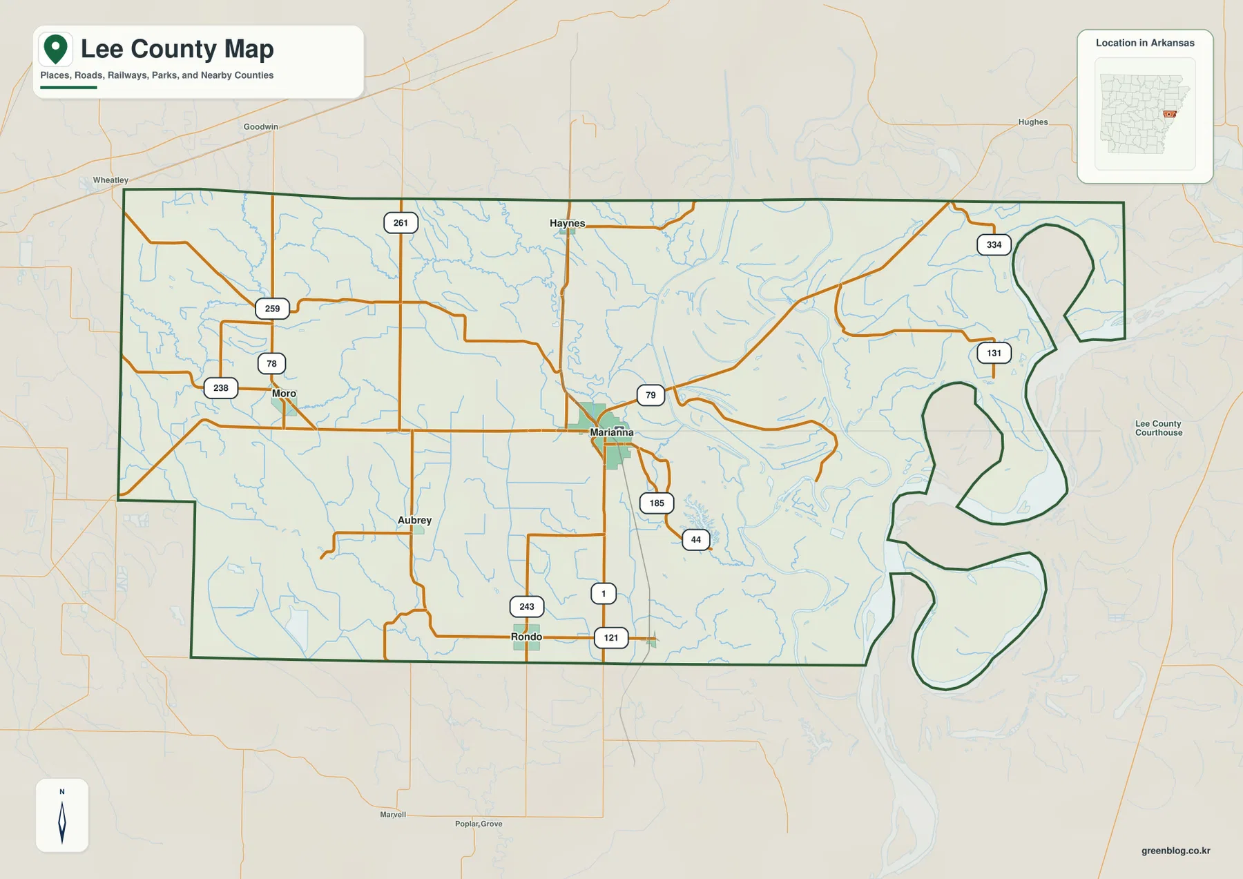
The eastern county outline is especially distinctive. Instead of a long straight border, several large loops and narrow necks follow the Mississippi River side, creating three prominent rounded projections. The western and southern edges are much simpler by comparison. St. Francis County lies to the north, Monroe County is west, and Phillips County borders the south and southwest. The county’s river-shaped eastern edge becomes much easier to understand after looking at the terrain and water map.
The ranked city map shows Marianna as the clear center of a dispersed rural county
The city map ranks six communities. Marianna is number 1, Moro 2, Aubrey 3, Rondo 4, Haynes 5, and Lagrange 6. These numbers are ranking markers rather than distance labels. Marianna occupies the center-east, while the other five places are scattered west, southwest, south, north, and southeast. The pattern is noticeably different from counties where several major cities form a continuous urban corridor.
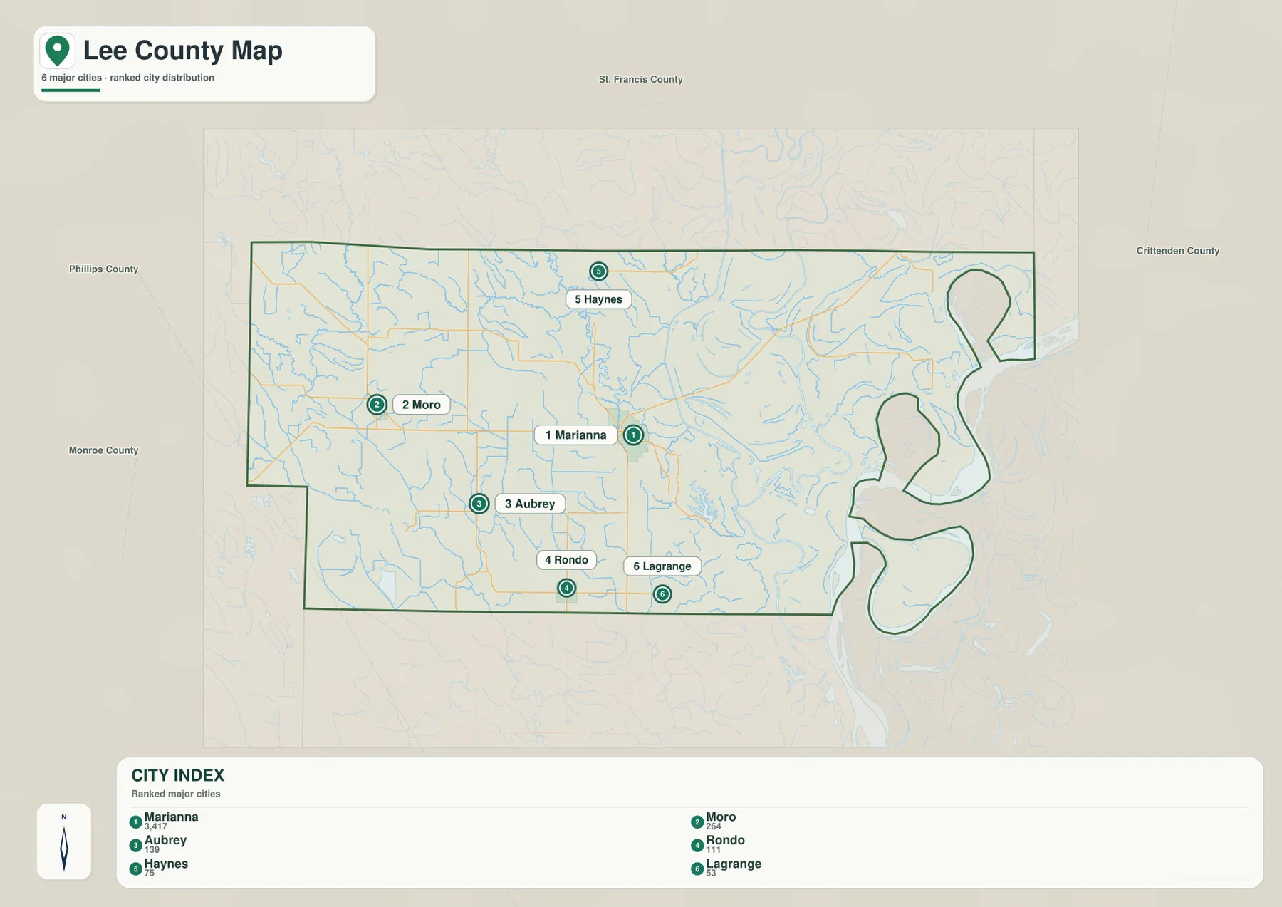
Moro sits west of Marianna within the western road network, while Aubrey and Rondo occupy the lower half of the county. Haynes is close to the northern edge, and Lagrange is farther southeast. Returning to the general map after viewing the city ranking makes it clear that most of the named communities are separated by large areas of rural land. The broad Mississippi River side, in particular, contains few of the six ranked places even though it occupies a substantial part of the map.
The city legend includes numeric values beside the names, but this article does not reinterpret those figures as current population estimates. The supplied map clearly supports the ranking and locations of the six communities, so those are the facts used here. Current population figures should be checked against a recent Census source. Marianna’s status as county seat is supported separately by Lee County reference material.
L’Anguille River crosses the ridge near Marianna before reaching the eastern lowlands
The L’Anguille River is the most important named interior waterway on the terrain and water map. It descends through the northern part of the county, passes near Marianna, and bends toward lower ground to the east. The Encyclopedia of Arkansas explains that the river normally follows the western side of Crowley’s Ridge but cuts east across the ridge near Marianna. The supplied elevation map supports that geographic relationship by showing higher ridge sections north and south of the city with a lower gap between them.
Several smaller creeks drain the western and central parts of the county. Big Creek occupies the northwest, Hog Thief Creek runs through the southwest, and Big Cypress Creek follows a long central-southern route. Their valleys are subtle because the surrounding land is already low, but they help divide an otherwise broad plain. The water map is particularly useful here because many small channels are difficult to notice on the general road map.
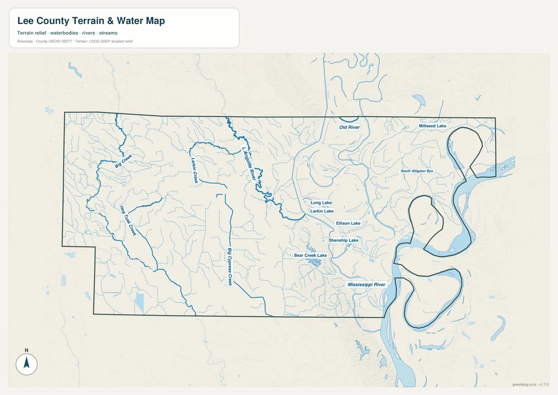
East of Marianna, the water pattern becomes much more complex. Long Lake, Larkin Lake, Ellison Lake, Shenship Lake, and Bear Creek Lake are scattered across the lowland, while Old River and Millseed Lake appear farther north. At the county’s eastern edge, the Mississippi River creates enormous bends around the irregular boundary, and South Alligator Bayou is labeled within the same low country. The curved lakes and secondary channels give this side of Lee County a strong river-plain character.
This terrain and water map is intended for general geographic reference. It does not provide current Mississippi River or L’Anguille River stage, flood risk, navigation conditions, fishing rules, property boundaries, or live road access. River conditions can change with rainfall and upstream flow. For recreation, flooding, or safety decisions, use current USGS information and guidance from the agency responsible for the specific waterway.
Elevation stays low across most of Lee County, with a narrow ridge rising near Marianna
The supplied elevation map shows an actual countywide range of about 44 to 117 meters, with a mean near 60 meters. That is only about 73 meters of total relief, yet the contrast is easy to see because most of the county is broad green lowland. Higher brown and tan terrain appears in narrow sections north and south of Marianna, while the Mississippi River side and most of the western half remain much lower.
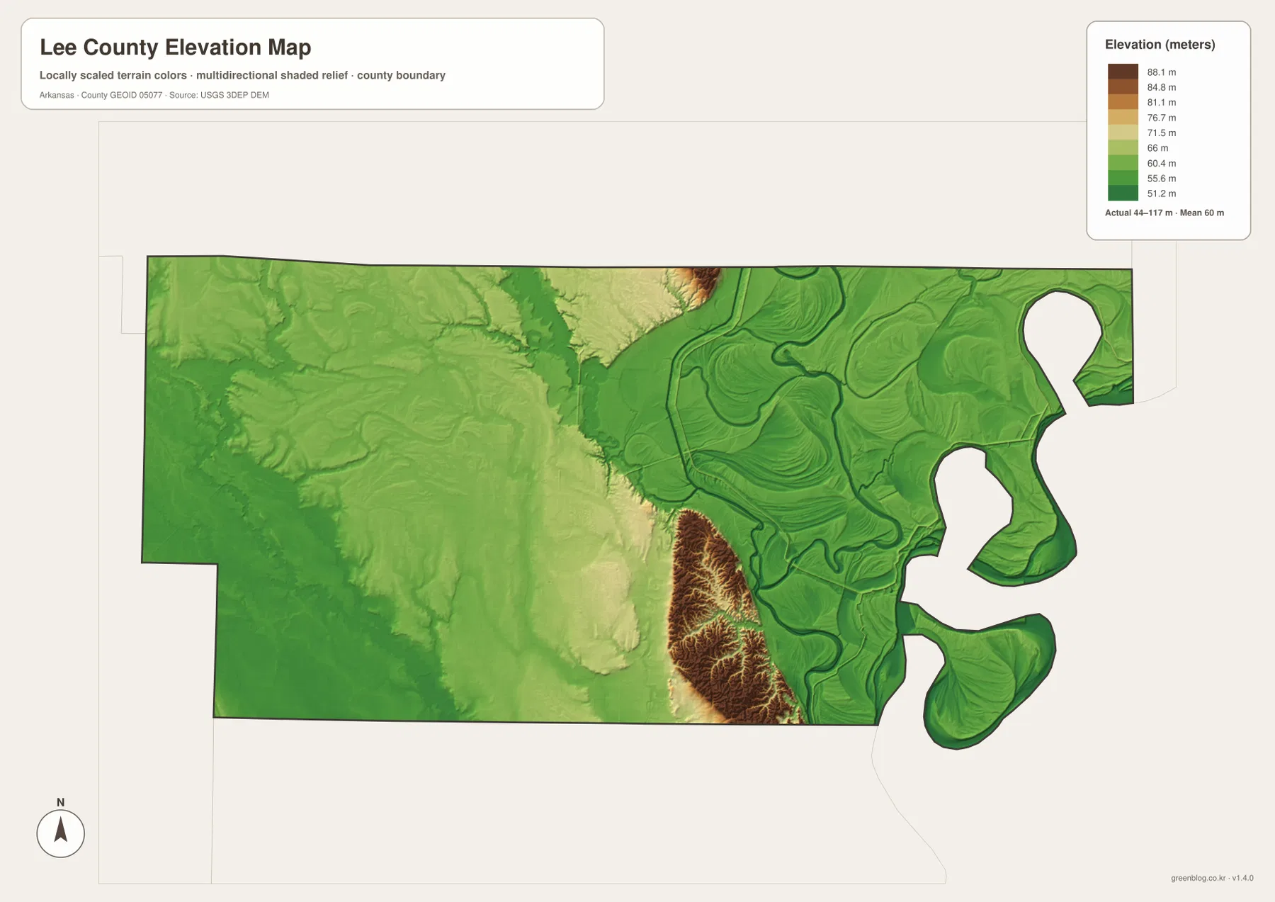
Crowley’s Ridge is a narrow upland that rises above the otherwise flat Mississippi Alluvial Plain of eastern Arkansas. In Lee County, the ridge is interrupted near Marianna where the L’Anguille River crosses it. That feature is visible in the supplied map as two higher zones separated by a lower corridor near the city. The southern ridge section is especially distinct, with short slopes and small valleys standing out sharply against the surrounding low green surface.
Once the ridge is left behind, elevation drops quickly. The eastern Mississippi River side is dominated by low ground marked by abandoned channels, river bends, and lakes, while the Moro and Aubrey side is also low but contains fewer large river features. The elevation image is designed for county-scale comparison rather than survey-grade measurement, so exact parcel, road, levee, or building heights require original elevation data or a professional survey.
Compare east and west from Marianna to understand the county fastest
A practical way to use the four maps together is to begin at Marianna and look east. Route 79 and the L’Anguille River lead toward Long Lake, Larkin Lake, and the broad Mississippi River lowland, where curved channels and water bodies become increasingly common. The elevation colors remain mostly green in that direction. Looking west toward Moro and southwest toward Aubrey brings a different lowland landscape, with Big Creek and Hog Thief Creek replacing the large river bends as the most visible water features.
Marianna itself sits at the transition between these map patterns. Roads concentrate around the city, the L’Anguille River passes nearby, and the higher sections of Crowley’s Ridge appear to the north and south. That combination makes Marianna more than a simple urban marker. Comparing the same area on the general, water, and elevation maps explains why the city’s location is so useful for understanding the rest of Lee County.
High-resolution JPG files for Marianna roads and Mississippi River detail
The WebP images in the article are optimized for quick page viewing. The download ZIP contains the same four maps as high-resolution JPG files, each measuring 3638 × 2572 pixels in landscape orientation. Use the general map for communities and roads, the ranked city map for the six major places, the terrain and water map for the L’Anguille River, Mississippi River, creeks, and lakes, and the elevation map for comparing Crowley’s Ridge with the surrounding lowlands.
The JPG files are suitable for classroom reference, presentations, trip preparation, personal printing, and general orientation. They should not replace legal boundary records, parcel surveys, flood studies, engineering plans, or live navigation. When exact or current information is required, consult Census TIGER/Line boundaries, USGS hydrography, USGS elevation data, and the appropriate local or state source for the specific decision.
Frequently Asked Questions
Where is Marianna within Lee County?
Marianna is the county seat and the largest mapped community, positioned slightly east of center. Route 79 crosses the area, several roads continue south, and the L’Anguille River passes nearby. Those features make Marianna the easiest reference point for using the general, water, and elevation maps together.
Do the numbers 1 through 6 on the city map show distances?
No. They are ranking markers for the six communities shown on the map. Marianna is ranked first, followed by Moro, Aubrey, Rondo, Haynes, and Lagrange. The numbers do not represent straight-line mileage or driving distance.
How does Crowley’s Ridge appear on the elevation map?
The higher ridge sections appear as narrow brown and tan areas north and south of Marianna. The map shows an actual elevation range of about 44–117 meters with a mean near 60 meters. Near Marianna, the L’Anguille River crosses the ridge, creating a lower break between the higher sections.
Map File Information
The ZIP contains the general county map, ranked city map, terrain and water map, and elevation map as high-resolution JPG files for printing or offline reference.
- File Type: ZIP containing 4 JPG files
Related Maps
Sources and references
- Encyclopedia of Arkansas – Lee County – Marianna, the Mississippi River boundary, and county geography
- Encyclopedia of Arkansas – Crowley’s Ridge – the eastern Arkansas ridge and its break near Marianna
- Encyclopedia of Arkansas – L’Anguille River – the river at Marianna and its crossing of Crowley’s Ridge
- U.S. Census Bureau TIGER/Line Shapefiles – county boundary and road data
- USGS National Hydrography – rivers, streams, lakes, and hydrography data
- USGS 3D Elevation Program – elevation and terrain data
Green Map creates custom-edited map images using open geographic data sources such as geoBoundaries, Natural Earth, OpenStreetMap, and government open data.
These maps are edited visual materials, not raw data files, and are provided for education, documents, presentations, and graphic reference.