Fulton County occupies the north-central edge of Arkansas, where the Ozark hills reach the Missouri state line and a dense network of creeks cuts through the uplands. Salem sits near the middle of the county and works well as a reference point for the road system, while Mammoth Spring lies at the far northeastern side near the headwaters of the Spring River. The western and central portions are generally higher and more rugged, and the eastern side contains lower river valleys. This page combines those features in four maps, with the same maps available as high-resolution JPG files in one downloadable ZIP.
Salem is the county seat. The Encyclopedia of Arkansas describes Fulton County as part of the Ozark Foothills and notes that it borders Missouri on the north, Sharp County on the east, Izard County on the south, and Baxter County on the west. Those relationships are easy to follow on the general map because Salem is centrally placed, Viola sits well to the west, and Mammoth Spring is close to the Missouri line in the northeast. The county’s long east-west shape also makes the contrast between upland roads and river valleys especially noticeable.
Table of Contents
Use Salem as the starting point for roads and communities
Salem is the clearest anchor on the county map. Route 9 heads south from the city, while Routes 27 and 395 connect Salem with areas to the west and northwest. Route 62 continues toward the southeastern side of the county. Instead of trying to memorize every road number, first locate Salem and then follow the roads outward toward Viola, Mammoth Spring, and the communities near the southeastern boundary. That makes the overall road pattern much easier to understand.
Farther west, Routes 87 and 223 serve the upland side of the county. In the northeast, Routes 289 and 342 appear around Mammoth Spring, while Route 63 runs along the eastern side. Routes 62 and 412 are visible near Cherokee Village and Ash Flat toward the southeast. The map includes nearby places outside the county boundary as context, which helps show how Fulton County fits between Baxter, Izard, and Sharp counties and the Missouri border.
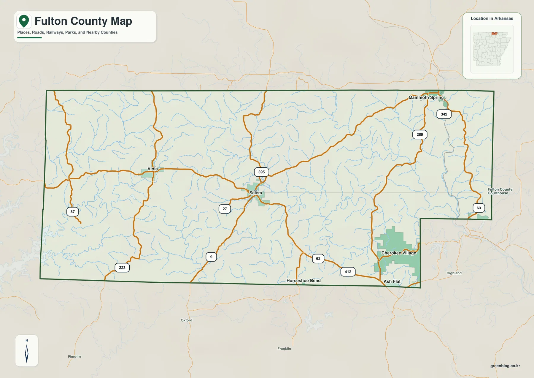
The southeastern boundary is more irregular than the long northern and western edges. Cherokee Village is shown close to that inset, with Ash Flat and Horseshoe Bend nearby for orientation. Looking at those places together helps explain why the county outline changes shape near the Sharp and Izard county sides. The basic map is particularly useful here because it shows roads, towns, streams, and neighboring areas in one view rather than isolating a single feature.
Salem, Mammoth Spring, and Viola form a wide city triangle
The city map ranks three major communities: Salem first, Mammoth Spring second, and Viola third. These numbers are ranking labels, not distance measurements. Their positions are widely separated across the county. Salem is near the center, Viola lies to the west, and Mammoth Spring is close to the northeastern corner. That spread is more informative than the ranking alone because it shows that the main communities are distributed across different parts of a largely rural county.
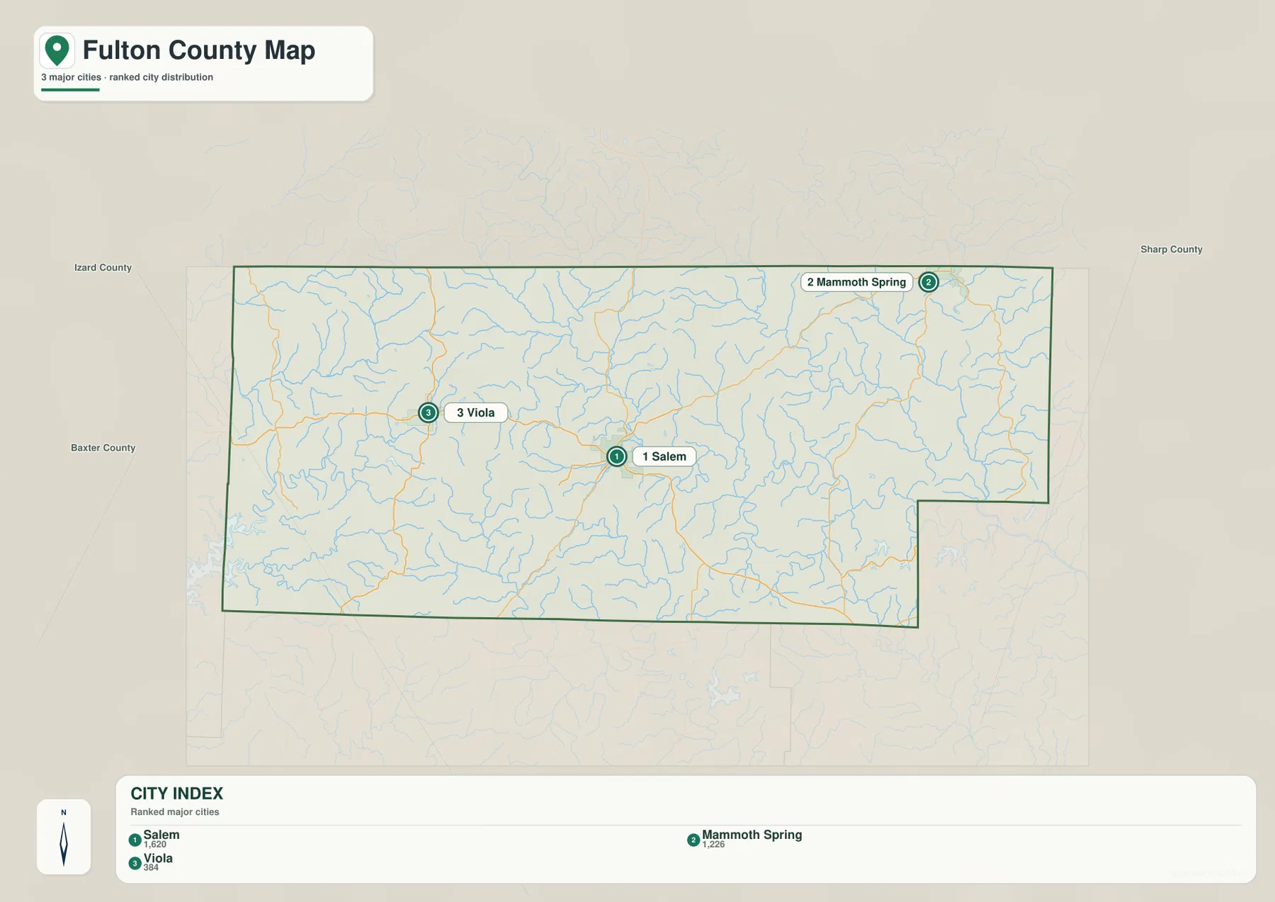
Traveling west from Salem toward Viola crosses a landscape of ridges, hollows, and small streams. Moving northeast toward Mammoth Spring leads toward the Spring River drainage and lower valleys on the eastern side. The city map is useful for direction and distribution, but it does not provide driving mileage or straight-line distances. For an actual trip, use the county overview to understand the setting and a current navigation map for travel time and route conditions.
The Encyclopedia of Arkansas lists four incorporated cities in Fulton County: Salem, Mammoth Spring, Cherokee Village, and Viola. The simplified city map on this page ranks only three major cities, so the absence of Cherokee Village from that view should not be interpreted as meaning it is outside the county. Cherokee Village is visible on the general map near the southeastern boundary. Comparing the two maps prevents that simplified city ranking from being mistaken for a complete municipal list.
Spring River begins near the Missouri line and anchors the eastern drainage
The Spring River is the best-known water feature on the northeastern side of Fulton County. Arkansas State Parks explains that water from Mammoth Spring forms a lake and then flows southward as the Spring River. On the terrain and water map, the river appears near the Missouri line and continues through the eastern side of the county. The valley around it is visibly lower than many of the ridges farther west, so the water and elevation maps reinforce each other particularly well in this area.
The South Fork Spring River winds across the central-eastern part of the county, with Town Creek joining the broader drainage. Farther south, the Strawberry River and Little Strawberry River occupy another set of valleys. In the western half, Big Creek and South Brushy Creek pass through higher and more dissected terrain, while Bennett Creek, Bennetts River, and Trace Creek are labeled farther north. The dense network of smaller blue lines shows how thoroughly streams have cut into the Ozark uplands.
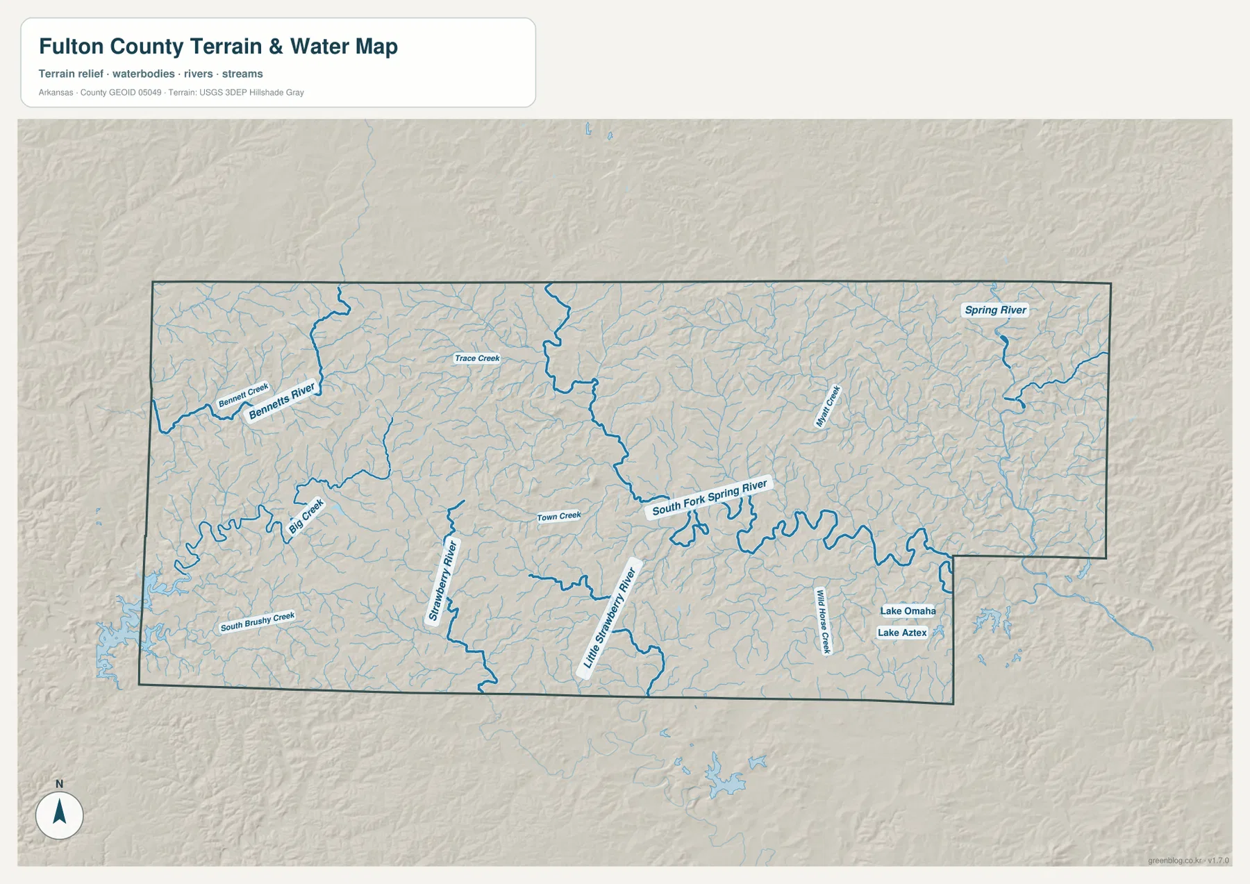
Lake Omaha and Lake Aztec are labeled near the southeastern side, with Wild Horse Creek nearby. They are much smaller than the river systems but provide useful landmarks when comparing the southeastern corner with the rest of the county. The western side has fewer large named water bodies and a more intricate pattern of short tributaries cutting through hills. Reading the two sides together helps explain why the county feels different from west to east even though all of it lies within the Ozark region.
This terrain and water map is intended for general geographic reference. It should not be used to determine current river stage, flood risk, property boundaries, fishing regulations, or safe access to private land. Water conditions on the Spring River and smaller streams can change with rainfall. For recreation or safety decisions, check current information from USGS, Arkansas State Parks, or the agency responsible for the specific waterway.
Elevation ranges from about 110 to 342 meters
The elevation map shows an actual range of about 110 to 342 meters, with a mean near 226 meters. That is roughly 232 meters of relief within the county. Brown and tan colors are concentrated across much of the western and west-central uplands, while greener, lower terrain becomes more common toward the east. The Spring River and South Fork Spring River valleys stand out as lower corridors among the surrounding ridges.
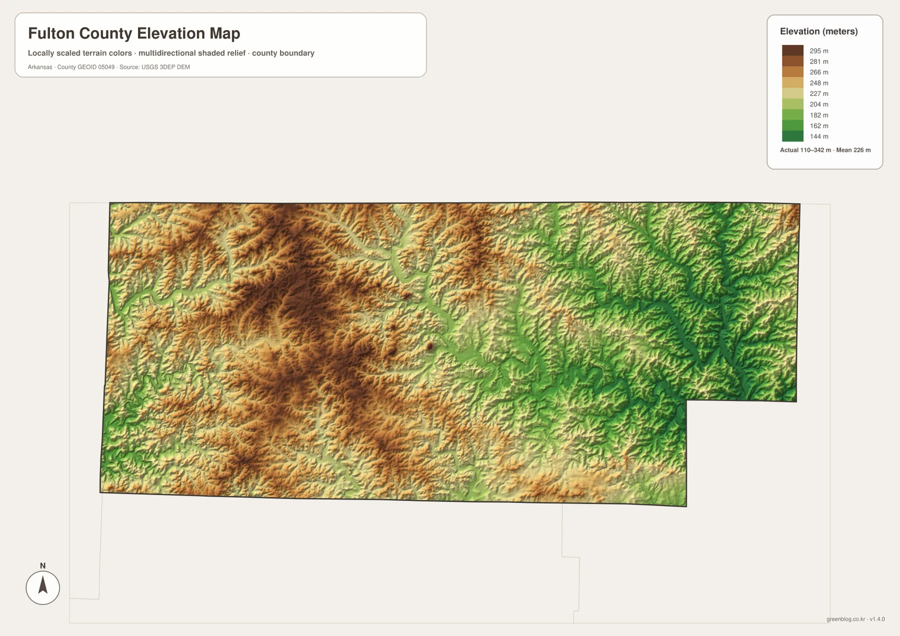
Around Viola and the western half, the terrain appears as a repeated series of ridges and narrow valleys rather than one isolated mountain. East of Salem, greener colors become more frequent as the landscape descends toward the South Fork Spring River and Spring River systems. The same change can be seen in the water map, where named rivers occupy the larger low corridors and many smaller tributaries branch into the surrounding slopes.
The elevation image is designed for county-scale comparison, not survey-grade measurement. The 110–342 meter range is useful for understanding how much the terrain changes across Fulton County, but it should not be used as the exact elevation of a parcel, road, bridge, or building. Engineering, construction, drainage design, and precise site work require original USGS 3D Elevation Program data or a professional survey.
Compare east and west from Salem to see the county’s main contrast
A simple way to work through the maps is to begin at Salem and compare the county in opposite directions. West toward Viola, the land is generally higher and more broken, with many short streams cutting between ridges. East and northeast, the South Fork Spring River and Spring River occupy broader low corridors. The southeastern corner adds Cherokee Village, Lake Omaha, and Lake Aztec, making it useful for comparing settlement, water, and terrain in the same area.
Mammoth Spring is easiest to locate by first finding the Missouri border. The city sits close to the northeastern edge and is directly associated with the spring that feeds the Spring River. Viola, by contrast, lies in the western uplands. Looking back and forth between those two ends of the county makes the east-west terrain difference much more obvious than reading an elevation number by itself.
High-resolution JPG files for printing and close viewing
The WebP images in the article are optimized for quick page viewing. The download ZIP contains the same four maps as high-resolution JPG files, each measuring 3638 × 2572 pixels in landscape orientation. The general map is best for roads and communities, the city map simplifies the major settlement pattern, the terrain and water map emphasizes rivers and named creeks, and the elevation map makes the western uplands and eastern valleys easier to compare.
These files can be used for classroom reference, trip preparation, presentations, personal printing, and general orientation. They are not replacements for legal boundary records, parcel surveys, flood studies, engineering plans, or live navigation. When exact or current information matters, check Census TIGER/Line boundaries, USGS hydrography, USGS elevation data, and the responsible state or local agency.
Frequently Asked Questions
What is the county seat of Fulton County?
Salem is the county seat. It appears near the center of the general map, where several important roads meet or branch toward other parts of the county. Using Salem as the starting point makes it easier to locate Viola to the west, Mammoth Spring to the northeast, and Cherokee Village toward the southeast.
How are Mammoth Spring and the Spring River connected?
Arkansas State Parks explains that the large natural spring at Mammoth Spring forms a lake and then flows southward as the Spring River. On the map, Mammoth Spring is close to the Missouri line in northeastern Fulton County, with the Spring River visible in the same part of the county.
Do the numbers on the city map show distances?
No. The numbers rank the three major cities shown on this simplified view: Salem, Mammoth Spring, and Viola. They are not mileage values or straight-line distances. Use a current road or navigation map when you need actual travel distance or time.
Map File Information
The ZIP contains the general county map, ranked city map, terrain and water map, and elevation map as high-resolution JPG files for printing or offline reference.
- File Type: ZIP containing 4 JPG files
Related Maps
Sources and references
- Encyclopedia of Arkansas – Fulton County – county location, county seat, incorporated cities, and local geography
- Arkansas State Parks – Mammoth Spring State Park – official information about Mammoth Spring and the Spring River
- U.S. Census Bureau TIGER/Line Shapefiles – county boundary and road data
- USGS National Hydrography – rivers, streams, and waterbody data
- USGS 3D Elevation Program – elevation and terrain data
Green Map creates custom-edited map images using open geographic data sources such as geoBoundaries, Natural Earth, OpenStreetMap, and government open data.
These maps are edited visual materials, not raw data files, and are provided for education, documents, presentations, and graphic reference.