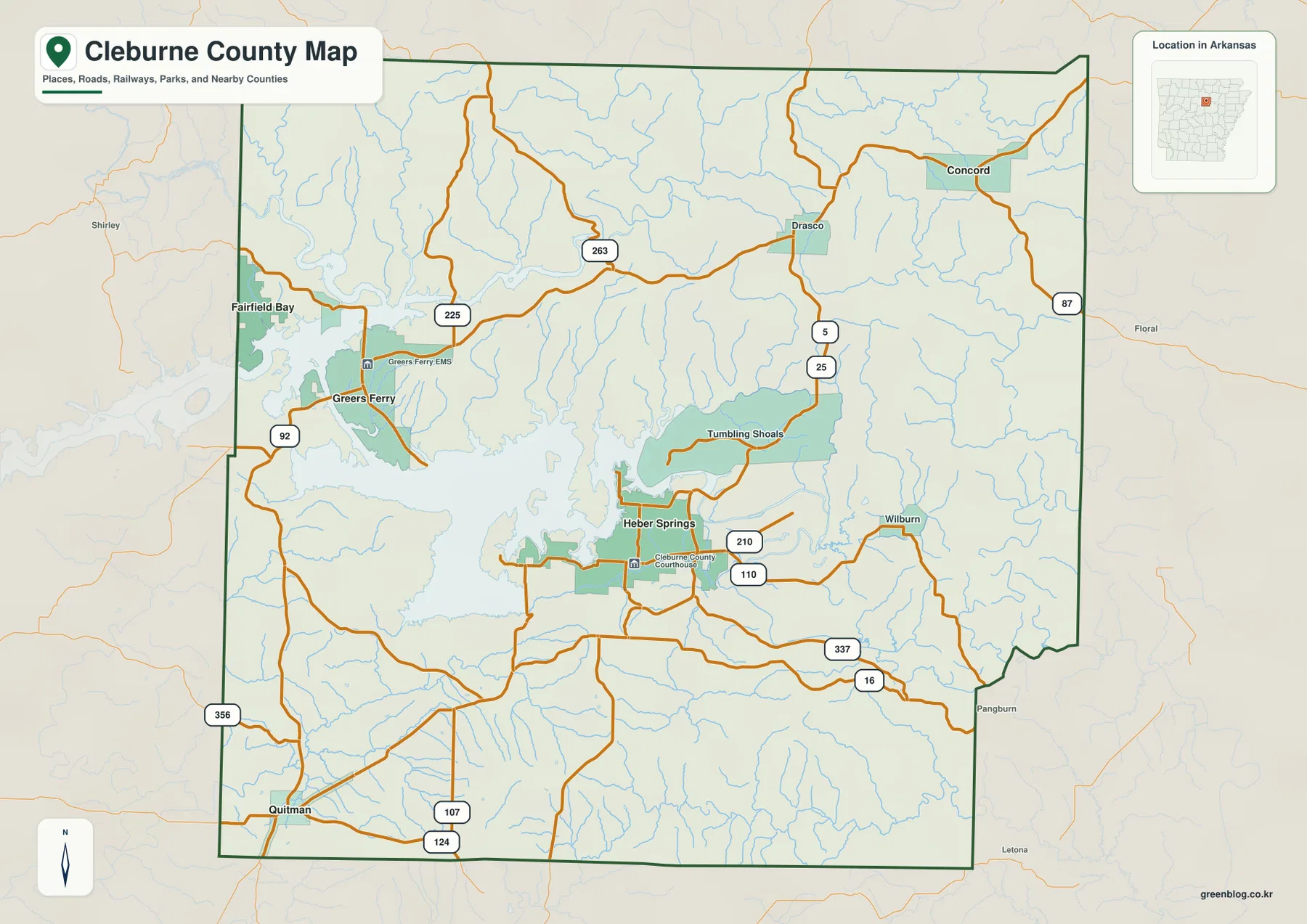
This Cleburne County Arkansas Map page provides web previews for roads, towns, waterways, and elevation, plus a downloadable ZIP containing four high-resolution JPG originals. Heber Springs is the most useful place to start because it sits just southeast of Greers Ferry Lake, close to several major roads and near the Little Red River corridor. Greers Ferry and Fairfield Bay lie toward the western lake side, Quitman is farther southwest, and Concord stands well apart in the northeast. Together, those places show a county shaped as much by water and ridges as by its road network.
Greers Ferry Lake is the dominant physical feature in the western and central parts of the county. Its long branching arms occupy valleys between hills, so nearby communities are not always linked by a simple straight route. North and northeast of the lake, the land becomes more rugged, while lower corridors follow the reservoir and the Little Red River toward the southeast. The supplied elevation map reports a county-wide range of about 68 to 411 meters and an average near 222 meters, making the contrast between ridge tops and valley floors easy to see.
The maps are designed for orientation rather than live navigation or engineering work. They can help you understand how Heber Springs, Greers Ferry, Concord, Quitman, the lake, and the main streams fit together, but they do not provide current road closures, lake levels, flood warnings, legal parcel boundaries, or survey-grade elevation. For those uses, current agency data and professional measurements are still required.
Table of Contents
Heber Springs sits where the central roads meet the lake’s southeastern side
On the general county map, Heber Springs is the clearest central reference point. Routes 25, 110, and 210 are labeled around the city, while the shoreline of Greers Ferry Lake reaches in from the west and northwest. Tumbling Shoals appears north of town near an eastern arm of the reservoir, and Wilburn is farther east. Continuing north leads toward Drasco along Route 5 before the map opens into the higher northeastern part of the county.
Concord gives that northeastern area a separate anchor. It sits near Route 87 and away from the main reservoir, so its surroundings are defined more by ridges, small drainage lines, and local roads than by large water. West of Heber Springs, Greers Ferry is centered near Routes 92 and 225, where the shoreline is heavily indented. Fairfield Bay reaches the western county edge, with lake arms and narrow land connections shaping the road pattern.
Quitman marks the southwest and appears near Routes 107 and 124. Pangburn is labeled beyond the southeastern boundary, giving another reference point outside the county. Instead of memorizing every highway number, it is easier to place Heber Springs first and then use Greers Ferry, Concord, and Quitman to establish west, northeast, and southwest. The smaller communities and secondary roads become much easier to understand once those larger anchors are fixed.
The main towns are spread between the reservoir, southwest interior, and northeast ridges
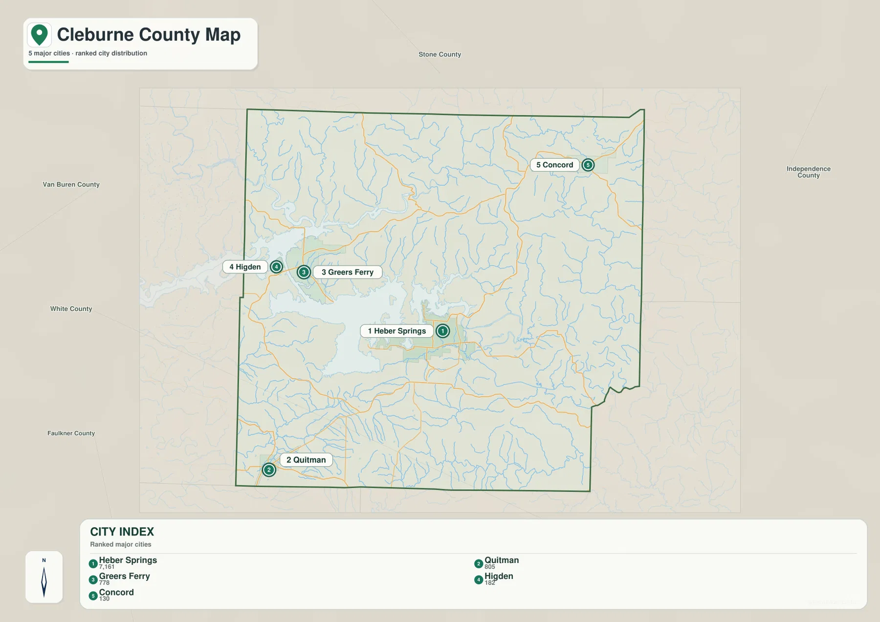
The city index highlights Heber Springs, Quitman, Greers Ferry, Higden, and Concord. With most road detail removed, the wide spacing between these places is easier to see. Heber Springs occupies the center-south, Greers Ferry and Higden cluster toward the western side of the lake, Quitman stands apart in the southwest, and Concord is isolated in the northeast. The pattern makes it clear that Cleburne County does not have one compact settlement belt.
Greers Ferry and Higden are both closely tied to the reservoir, but they occupy different parts of the shoreline. Higden lies farther north, while Greers Ferry is closer to the lake’s western-central portion. Heber Springs sits on the southeastern side where several roads converge. Quitman, by contrast, is inland and southwest of the main lake body, giving it a different relationship to the county’s terrain and drainage.
Concord is useful for understanding the northeastern section because it is well separated from the lakeside towns. The nearby landscape is more strongly associated with higher ridges and smaller creeks. Neighboring county names around the map—such as Stone, Independence, White, Faulkner, and Van Buren—help place these towns within north-central Arkansas. The city index is a relative-location map, not a road-mileage or travel-time chart.
Greers Ferry Lake branches through the middle before water continues toward the Little Red River
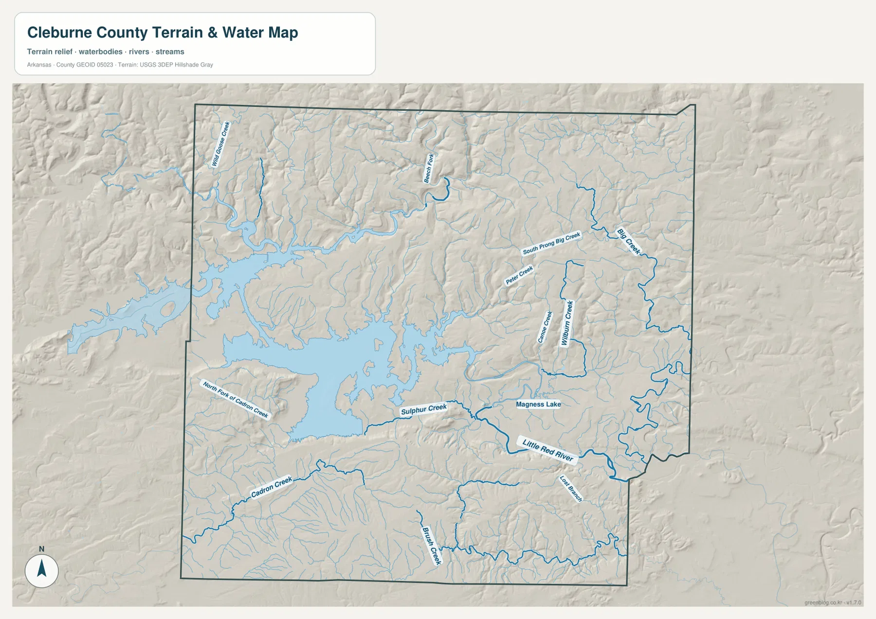
The water map is dominated by Greers Ferry Lake, whose shoreline forms long narrow arms rather than a simple rounded edge. Those arms extend into valleys toward the north, east, and south, separating roads and communities that may appear close in a straight line. This is especially noticeable around Greers Ferry, Higden, Tumbling Shoals, and the approach to Heber Springs, where travel routes must work around water and narrow land connections.
Sulphur Creek is labeled on the southeastern side of the reservoir, and the Little Red River continues through the southeastern part of the county. Basin Fork winds through the north, while Big Creek, South Prong Big Creek, Peters Creek, and Wilburn Creek appear across the northeast. These smaller streams follow valleys between ridges, so their curved paths make more sense when the hydrography and elevation maps are viewed together.
Other named features add detail away from the reservoir. Little Goose Creek appears in the northwest, North Fork of Cadron Creek crosses the southwest, and Cadron Creek and Brush Creek are shown farther south. Magness Lake is labeled in the eastern half. These features show that Cleburne County’s water geography is not just the large reservoir; smaller creeks and drainage valleys connect much of the surrounding upland terrain.
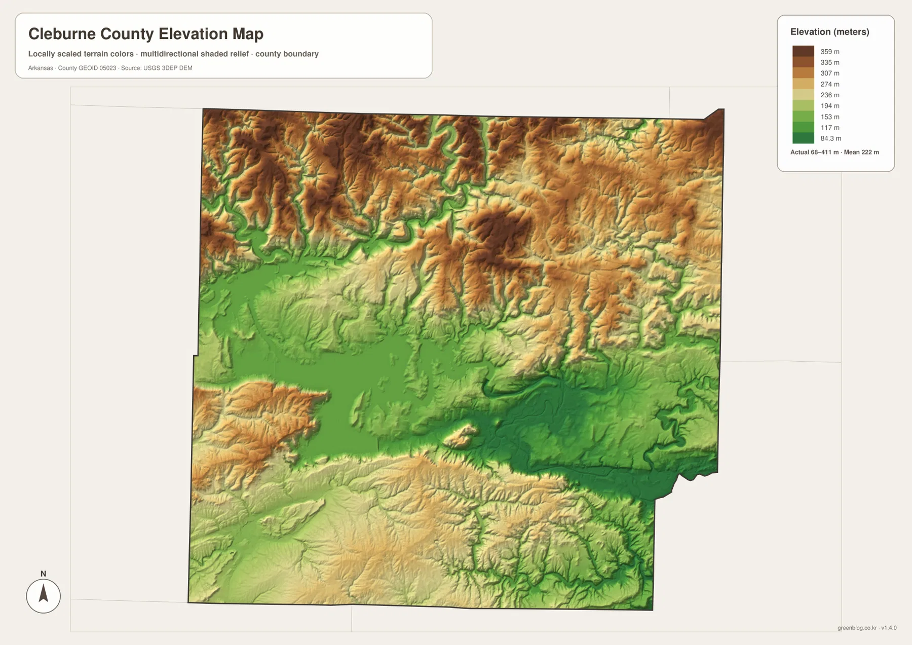
Northern ridges rise above lower lake and river corridors across a 68–411 meter range
The elevation map reports a low near 68 meters, a high near 411 meters, and a mean around 222 meters. The strongest high-relief areas are concentrated in the northwest, north, and northeast, where tan and brown ridges cover large sections of the map. Narrow green valleys cut between those ridges, often matching the creek channels labeled on the water map.
Greers Ferry Lake occupies a broad lower corridor through the west and center. Its arms fill valleys between higher ground, while the Little Red River continues through lower terrain toward the southeast. Near Heber Springs, this relationship helps explain why the city sits close to major water features but does not appear on the highest ridge belt. The lake is therefore both a dominant water feature and a useful marker for lower terrain.
The southwest around Quitman is generally less rugged than the northern ridge belt, but it is not flat. Hills and drainage valleys continue toward the southern boundary, and elevation changes remain visible. Cleburne County is therefore better described as a landscape of ridges surrounding lake and river valleys than as a simple north-high, south-low surface. The elevation layer is useful for broad comparison, but parcel-level construction or engineering requires detailed USGS data or field surveying.
Four local anchors make the county easier to remember
Heber Springs, Greers Ferry, Concord, and Quitman provide a practical framework for reading the county. Heber Springs is the central road and government reference point, Greers Ferry represents the reservoir’s western side, Concord identifies the higher northeastern interior, and Quitman marks the southwest. Once these four places are familiar, smaller communities such as Tumbling Shoals, Drasco, Higden, and Wilburn fit into the map more naturally.
The different map layers add a separate piece of information to those same places. Around Heber Springs, the general map emphasizes roads, the water map emphasizes the lake and Little Red River, and the elevation layer places the city near lower valley terrain rather than the highest ridges. Greers Ferry and Higden are more strongly tied to shoreline shape, while Concord is easier to understand through its ridge-and-creek setting. Quitman balances the picture by showing an inland southwestern section beyond the main reservoir.
Use the general map for boundaries, towns, and major road numbers; the city index for a simplified settlement comparison; the water map for the reservoir, river, and named creeks; and the elevation map for the high-low terrain contrast. Each file is most useful when it answers a specific question, so there is no need to force every detail into one image.
The western lake area also changes noticeably from town to town. Greers Ferry is closely tied to the reservoir shoreline, while Higden sits farther north where narrow lake arms push between hills. Fairfield Bay reaches the western edge of the county and is easier to place when the neighboring Van Buren County side is kept in view. Heber Springs has a different role because it combines proximity to the reservoir with a stronger road concentration, making it more useful as a county-wide orientation point than as a purely lakeside town.
North and northeast of the reservoir, the map becomes increasingly defined by relief. Around Drasco and toward Concord, ridge tops and narrow valleys repeat across the terrain. Basin Fork, Big Creek, South Prong Big Creek, and smaller channels follow lower ground between those ridges. On the road map, this helps explain why routes often bend instead of crossing the county in simple straight lines. The elevation layer turns what looks like an irregular road pattern into a more understandable response to hills, valleys, and drainage.
The southeastern side around the Little Red River presents another contrast. Rather than the wide branching reservoir, this area is organized around a narrower river corridor and lower valley terrain. Heber Springs sits close enough to both water systems that it works as a transition point between the reservoir landscape and the river valley. This relationship is especially useful when explaining the county to someone unfamiliar with the area because it connects settlement, roads, water, and elevation in one recognizable place.
The neighboring county labels also help with orientation. Stone County lies to the north and northwest, Independence County is toward the northeast and east, White County is to the southeast, Faulkner County is south, and Van Buren County lies to the west. These surrounding names make the long shape of Cleburne County easier to understand and show why Greers Ferry Lake reaches close to the western edge while Concord remains well inland in the northeast.
When the maps are used in a lesson, presentation, or report, there is no need to rely on one layer for every purpose. The general map is best for boundary and road context, the city index gives a cleaner settlement overview, the water map isolates the reservoir and stream network, and the elevation map explains the ridge-and-valley relief. Using two maps together can often answer a question more clearly—for example, pairing water with elevation shows why lake arms and creeks follow certain valleys, while pairing the general map with the city index separates road detail from settlement location.
For printing or close inspection, the high-resolution originals are more useful than enlarged web previews. The ZIP below contains the county map, city map, water map, and elevation map at 3638 × 2572 pixels each. Small road numbers, stream names, shoreline details, and terrain colors are easier to inspect at that size, making the files suitable for lessons, presentations, reports, or personal reference.
Frequently Asked Questions
Where is Heber Springs in relation to Greers Ferry Lake?
Heber Springs sits on the southeastern side of Greers Ferry Lake, near several major roads and close to the Little Red River corridor. The water map makes that relationship especially clear because the city lies between the reservoir’s branching shoreline and lower river-valley terrain.
Which part of Cleburne County has the highest terrain?
The elevation map shows the most extensive higher ridges across the northwest, north, and northeast. Lower terrain follows Greers Ferry Lake and the Little Red River, within a county-wide elevation range of about 68 to 411 meters.
What is included in the downloadable ZIP?
The archive contains four high-resolution JPG files: the county map, city map, water map, and elevation map. Each image is 3638 × 2572 pixels, making small labels and terrain detail easier to inspect than on the web preview.
Map File Information
The ZIP contains high-resolution JPG originals for the Cleburne County general map, city map, water map, and elevation map.
- Included Files: County map, city map, water map, elevation map
- Printable Size: 3638 × 2572 px each
- File Type: JPG
Related Maps
Sources and references
- Official Cleburne County, Arkansas website: county government and community information.
- Encyclopedia of Arkansas – Cleburne County: background on Greers Ferry Lake, the Little Red River, and the county’s terrain.
- U.S. Census Bureau TIGER/Line Shapefiles: official reference for county boundaries, roads, and place geography.
- USGS National Hydrography: official reference for rivers, streams, and waterbodies.
- USGS 3D Elevation Program: official elevation and terrain reference.
Green Map creates custom-edited map images using open geographic data sources such as geoBoundaries, Natural Earth, OpenStreetMap, and government open data.
These maps are edited visual materials, not raw data files, and are provided for education, documents, presentations, and graphic reference.