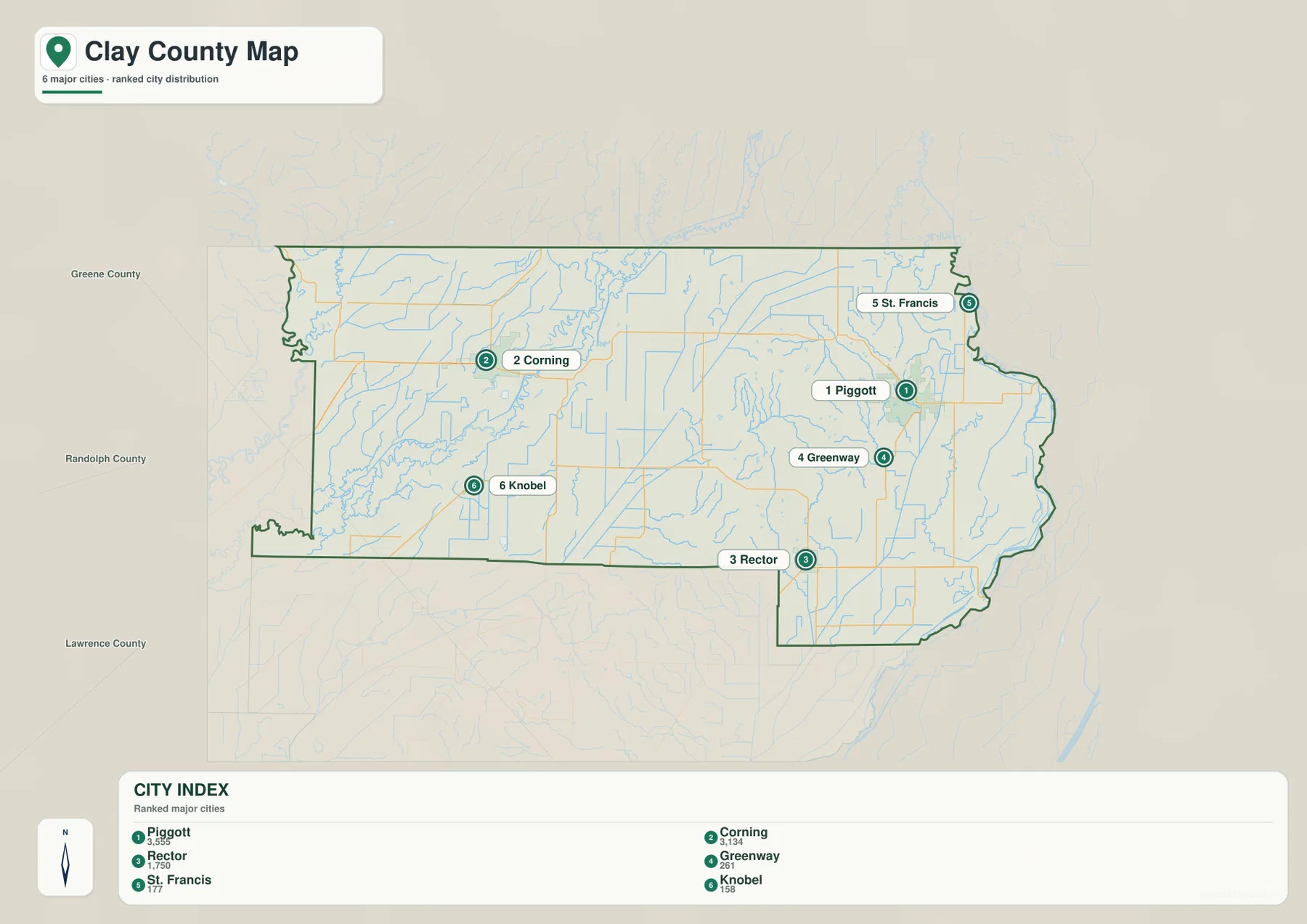
You can download four high-resolution JPG map files from this Clay County Arkansas Map page, while the web previews below make it easy to compare roads, towns, waterways, and elevation before choosing a file. Clay County sits in the northeastern corner of Arkansas, and its geography is easiest to understand by finding Corning on the western side and Piggott on the eastern side. Rector and Knobel mark the south, St. Francis lies close to the northeastern boundary, and a belt of higher land crosses the space between the two main population centers.
Corning and Piggott are more than convenient map labels: both serve as county seats. Their separation gives Clay County a distinctly two-sided layout. Roads and named lakes around Corning make the west easy to recognize, while Piggott is surrounded by eastern communities and routes that lead toward the Missouri border. In between, Crowley’s Ridge rises above lower ground associated with the Black River and St. Francis River systems.
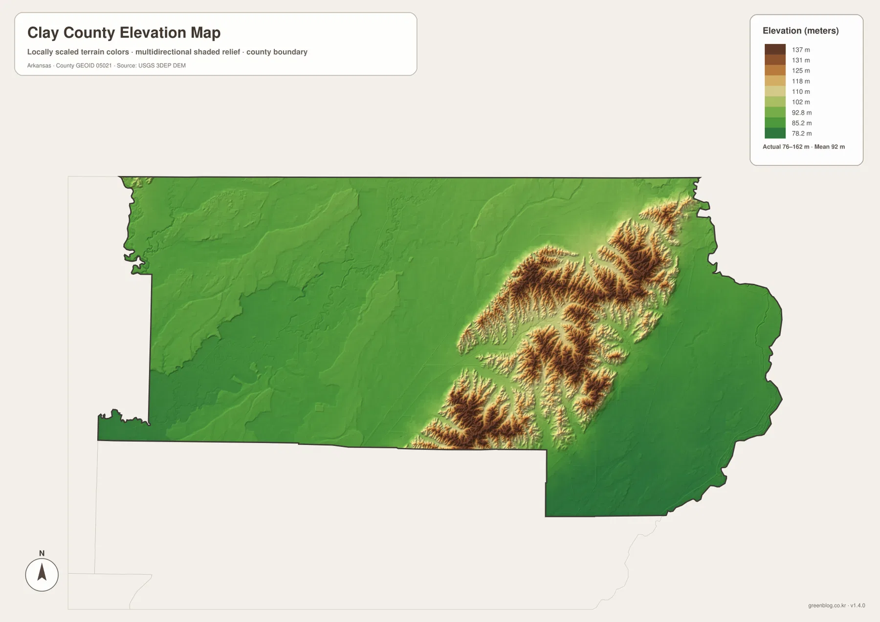
The elevation layer reports values from roughly 76 to 162 meters, with an average near 92 meters. Much of the county is low and gently varying, but the ridge zone appears in tan and brown and stands out from the greener lowlands on either side. When the elevation and water maps are viewed together, the relationship between the major rivers, low ground, and the higher ridge becomes one of the clearest geographic patterns in the map set.
Table of Contents
Two county seats make Corning and Piggott the best starting points
Corning is the strongest landmark on the western half of the general map. Route 67 passes the city, while Routes 211 and 328 appear toward Success in the northwest. Routes 90 and 135 extend through the interior, and Knobel lies farther south near Route 280. Instead of treating those road numbers as a list, use Corning as an anchor and follow the roads outward to Success, Datto, Knobel, and the middle of the county.
Piggott organizes the eastern side in a similar way, but its surroundings look different. Routes 62, 49, and 139 meet or pass near town, while Route 1 continues east. Pollard and St. Francis lie to the north and northeast; Rector and Nimmons are farther south. Because the eastern county boundary bends around these communities, locating St. Francis as well as Piggott helps show how close this side of Clay County is to Missouri.
The two county seats sit far enough apart that a visitor can use them as opposite ends of a mental map. Once Corning and Piggott are fixed, Rector, Knobel, Greenway, and St. Francis are much easier to place. This approach is more useful than memorizing every highway, especially for readers who only need a clear sense of where towns and boundaries lie within the county.
Success near the northwestern extension and St. Francis near the northeastern edge help define the upper boundary. Knobel and Rector do the same for the south. The general map therefore works best as an orientation sheet: it combines the county outline, communities, and major routes in one view. It is not meant to replace a current navigation service for road closures, construction, or turn-by-turn travel.
The six-city index shows how widely the county’s main communities are separated
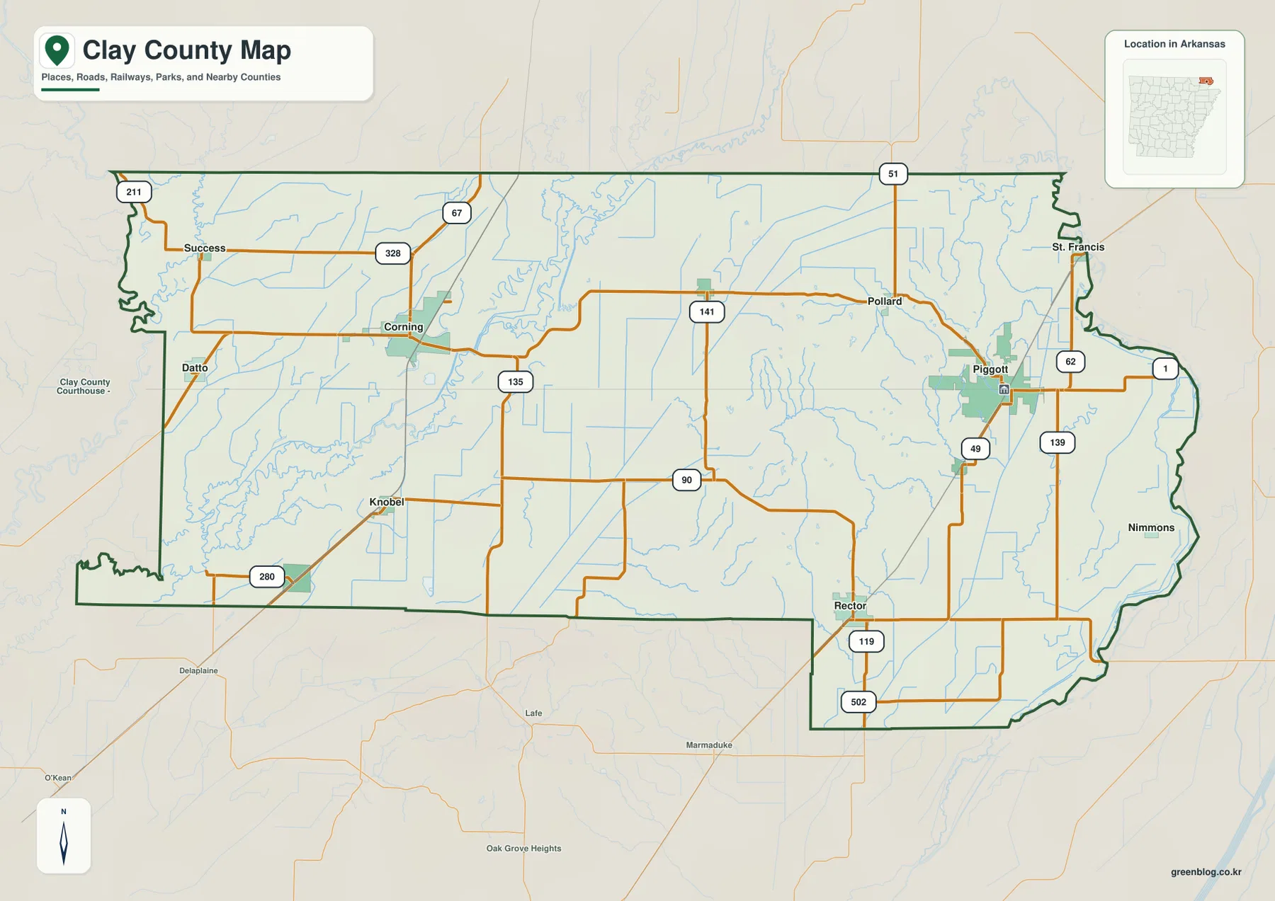
The city index highlights Piggott, Corning, Rector, Greenway, St. Francis, and Knobel. With most road detail removed, the east-west separation becomes more obvious than it is on the general map. Piggott and Corning sit on opposite sides of the county, Rector is farther south, and Greenway and St. Francis remain closer to Piggott. Knobel gives the western half a second southern reference point.
This arrangement explains why Clay County does not read like a county built around one dominant central city. Corning and Knobel form a western cluster, while Piggott, Greenway, and St. Francis create a more eastern grouping. Rector occupies the southern portion between those broad sides. The open space between the main towns contains rural land, streams, and the ridge zone rather than another large urban center.
The two-county-seat system also makes sense visually on this simplified map. Corning represents the west and Piggott the east, so placing those two cities first gives the rest of the settlement pattern a clear framework. Rector helps define the county’s southern reach, St. Francis marks the northeastern edge, and Knobel makes the southwestern side easier to recognize.
Labels outside the county show nearby Arkansas counties such as Greene, Randolph, and Lawrence, while Missouri lies beyond the northern and eastern sides. Those neighboring names are useful for regional orientation. The city index, however, is not designed to calculate travel distance or driving time; it is a simple location comparison map.
Black River and the Corning lakes dominate the west, while St. Francis River shapes the east
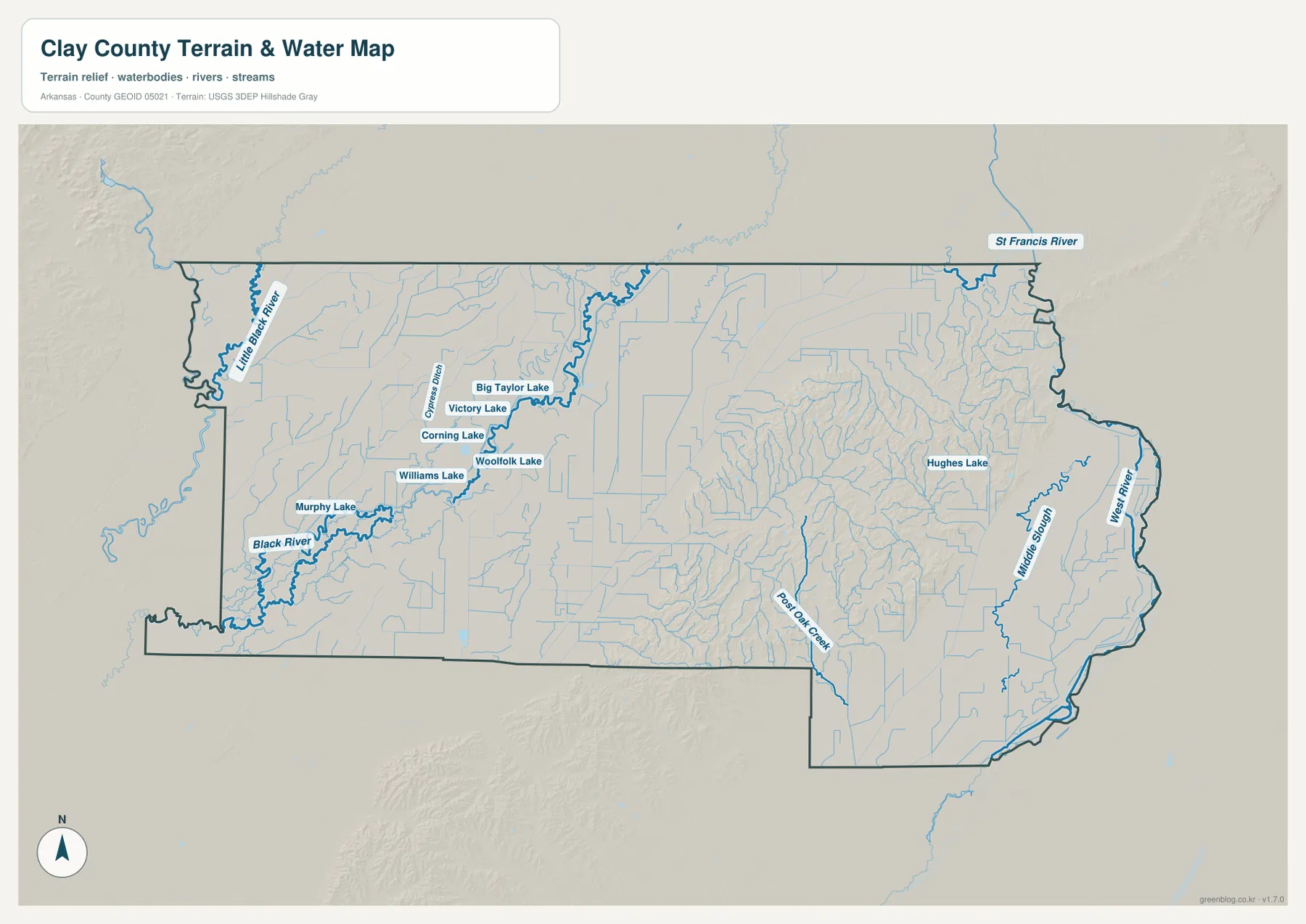
The water map gives the western side a very different appearance from the road map. Black River is one of the largest named features, with Little Black River visible toward the northwest. Around Corning, Murphy Lake, Williams Lake, Corning Lake, Woolfolk Lake, Victory Lake, and Big Taylor Lake are among the named waterbodies shown. That concentration makes water an important part of the western Clay County map, even though roads draw more attention in the general view.
Farther east, St. Francis River becomes the main large river label. Small streams and drainage channels extend around the Piggott and Rector side, and Hughes Lake appears in the east-central area. Numerous thin blue lines cross the county’s interior as well, showing that the space between the two major river systems contains many smaller waterways rather than one broad dry corridor.
Corning and Piggott provide a useful comparison again. Around Corning, Black River and a cluster of named lakes are easy to identify. Near Piggott, the St. Francis River side and smaller eastern channels are more prominent. Pairing towns with nearby water features makes the county’s internal differences easier to remember and shows why the water map adds information that a road map alone cannot provide.
This map is for geographic reference, not for flood forecasting, boating decisions, parcel boundaries, or legal shoreline limits. A blue line or polygon does not indicate current depth or flood status. For safety, engineering, or property decisions, use current agency data intended for those purposes. Here, the map is best used to find the location and overall distribution of rivers, streams, and lakes.
Crowley’s Ridge interrupts the lowlands within a 76–162 meter elevation range
Clay County’s elevation map gives a county-wide range of about 76 to 162 meters and a mean near 92 meters. The western and far eastern portions are largely green, indicating relatively low, gently varying ground. Through the middle-east, tan and brown bands rise above those lowlands. The contrast is strong enough that the higher zone can be recognized immediately without reading individual elevation values.
That higher belt corresponds with Crowley’s Ridge, which trends from southwest toward northeast. The ridge is not one smooth wall; short valleys and drainage lines cut through it, producing more color changes than the flatter land around Corning or along the eastern river side. This terrain helps explain why a west-to-east trip across Clay County is not simply a crossing of one uniform plain.
The water and elevation maps make an especially useful pair. The Black River side in the west sits mostly in lower ground, while the St. Francis River side in the east is also relatively low. Crowley’s Ridge occupies the higher space between them. Looking from Corning toward Piggott, the terrain therefore rises through the middle and then drops again toward the eastern lowlands.
The elevation layer is suitable for county-scale comparison, not property surveying. It can show where higher ridges and lower valleys are located, but it should not be treated as an engineering measurement for a specific site. Detailed construction, drainage, or land-development work requires original elevation data and professional field measurements.
Roads, rivers, and elevation together explain the county’s east-west split
A simple way to remember Clay County is to connect three broad zones. Corning, Knobel, Black River, and several named lakes characterize the west. Crowley’s Ridge forms the most noticeable higher terrain through the middle-east. Piggott, Rector, St. Francis, and the St. Francis River provide the main landmarks farther east. With those three zones in mind, the many minor roads and streams become much easier to place.
Corning is best understood by comparing the general and water maps. One view emphasizes Route 67 and the road connections around town; the other shows Black River and the nearby lakes. Piggott benefits from a different comparison. The general map explains the road network, while the elevation map places the city near the transition between Crowley’s Ridge and the lower eastern ground.
Rector, Greenway, Knobel, and St. Francis fill in the spaces between the main anchors. Rector helps define the southern eastern side, Greenway sits closer to Piggott, Knobel marks the southwestern side, and St. Francis identifies the northeastern edge. Connecting each community to nearby roads, water, or terrain makes the map easier to remember than treating the names as an isolated list.
The Missouri border and neighboring counties clarify Clay County’s northeastern setting
Clay County lies at the northeastern edge of Arkansas, and the labels outside the county make that position easy to recognize. Randolph and Greene counties appear to the west and southwest, Lawrence County lies farther south, and Missouri borders the northern and eastern sides. These surrounding names help place Corning and Piggott in a wider regional setting instead of treating them as isolated points inside one county outline.
Corning, Success, and the Black River side connect visually toward the western neighboring counties, while Piggott and St. Francis sit much closer to the Missouri-facing edge. Rector and Knobel help define the county’s southern width and make the transition toward Greene and Lawrence counties easier to follow. For readers unfamiliar with northeastern Arkansas, these outer reference points often make the boundary more memorable than the county shape by itself.
The border also becomes more meaningful when it is compared with terrain and water. Low ground extends along the St. Francis River side in the east, Crowley’s Ridge rises to the west of it, and the land drops again toward the Black River side around Corning. That sequence gives the eastern and western edges different geographic settings even though they belong to the same county.
Start with the feature you need, then choose the map that shows it clearly
For a first look, the general map is the best place to find Corning, Piggott, Rector, Knobel, Success, and St. Francis together with the main county roads. The city index is more useful when town locations are the only concern because it removes most of the road detail. If the goal is to find Black River, St. Francis River, or the lake cluster near Corning, the water map reaches the answer more directly.
The elevation map is the clearest choice for Crowley’s Ridge and the lowlands on either side. Comparing it with the water map also shows why the large rivers occupy lower ground while the ridge rises between them. For presentations or lessons, one map may be enough; for detailed reading of small labels, route numbers, water names, and elevation colors, the original JPG files are preferable to an enlarged web preview.
The ZIP below contains the general county map, city map, water map, and elevation map as 3638 × 2572 pixel JPG files. They match the subjects shown in the four web previews but provide the larger originals for printing, document insertion, classroom material, or personal reference.
Frequently Asked Questions
Why does Clay County have two strong map anchors instead of one?
Corning and Piggott both serve as county seats, and they are positioned on opposite sides of the county. Corning organizes the western road and Black River side, while Piggott provides the clearest reference for the eastern road network and communities near the Missouri border. Finding both first makes the rest of the map much easier to understand.
Where are the most noticeable named lakes on the water map?
Several named lakes appear around the Corning area, including Murphy Lake, Williams Lake, Corning Lake, Woolfolk Lake, Victory Lake, and Big Taylor Lake. They sit in the western side of the county near the Black River system and stand out much more clearly on the water map than on the general road map.
What does the 76–162 meter elevation map reveal about Crowley’s Ridge?
The elevation layer shows Crowley’s Ridge as a higher tan-and-brown belt between lower green areas on the western and eastern sides. The ridge helps explain the terrain change between Corning and Piggott, but the map is generalized for county-scale comparison and should not be used as a survey-grade elevation source.
Map File Information
The ZIP contains high-resolution JPG originals for the Clay County general map, city map, water map, and elevation map.
- Included Files: County map, city map, water map, elevation map
- Printable Size: 3638 × 2572 px each
- File Type: JPG
Related Maps
Sources and references
- Encyclopedia of Arkansas – Clay County: background on the county, its two county seats, Crowley’s Ridge, and regional setting.
- Association of Arkansas Counties – Clay County: county government and local background information.
- U.S. Census Bureau TIGER/Line Shapefiles: official reference for county boundaries, roads, and place geography.
- USGS National Hydrography: official reference for rivers, streams, and waterbodies.
- USGS 3D Elevation Program: official elevation and terrain reference.
Green Map creates custom-edited map images using open geographic data sources such as geoBoundaries, Natural Earth, OpenStreetMap, and government open data.
These maps are edited visual materials, not raw data files, and are provided for education, documents, presentations, and graphic reference.