Boone County sits in northern Arkansas, and Harrison is the easiest place to use as a starting point on the map. Roads spread from Harrison toward Omaha in the northwest, Bergman and Lead Hill to the northeast, and Bellefonte and Valley Springs to the southeast. Farther northeast, Diamond City lies close to Bull Shoals Lake and the White River. The four map images on this page let you move from roads and towns to waterways and elevation without losing that basic orientation. High-resolution A3 JPG versions are also available in a single ZIP, so readers who need a larger map for printing, classroom work, or documents can download the source-size files rather than relying on the smaller web previews.
The county is not defined by one simple feature. Harrison is the clearest road and administrative center in the supplied maps, but the northern half becomes easier to understand when the towns are viewed together with the White River system. The southwest stands out for a different reason: it is the highest part of the county in the elevation image. The provided elevation range is about 198 to 682 meters, with a mean shown near 361 meters. Looking at those features together gives a practical picture of Boone County without turning the page into a technical GIS report.
Table of Contents
Start with Harrison to orient the county
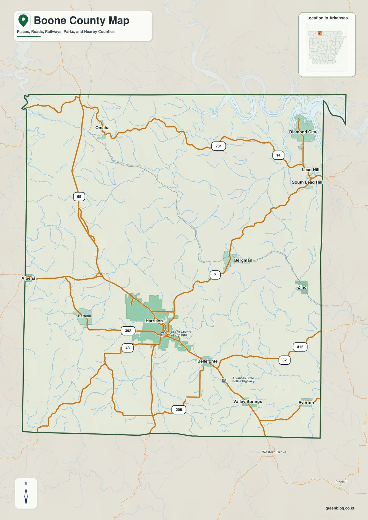
On the general county map, Harrison is the most useful reference point. Its built-up area is larger than the other labeled communities, and the Boone County Courthouse marker sits inside the city. From there, the road pattern makes the rest of the county easier to place. U.S. 65 runs north toward Omaha, while Route 7 leads northeast toward Bergman. Roads continue east and southeast through Bellefonte toward Valley Springs and Everton. West of Harrison, Batavia appears along the road network, while Alpena is shown near the western edge of the mapped county area.
The important point is not to memorize every route number. Harrison works as an anchor because several directions can be compared from the same place. Omaha is clearly northwest of the county seat, Bergman sits to the northeast, and Bellefonte is just southeast of Harrison. Lead Hill and Diamond City are much farther toward the northeastern edge. When those towns are read together, the map quickly shows which places belong to the Harrison-centered part of the county and which sit closer to the lake and river country in the northeast.
The dark county boundary also helps with roads that continue beyond Boone County. It gives the reader a clear frame for separating local routes and communities from labels in the surrounding area. This is useful for a county report, travel overview, or school project, but the image is not a live navigation map. Road closures, turn-by-turn directions, travel times, and current construction should be checked with an up-to-date navigation or transportation source.
The northern towns split into two distinct directions
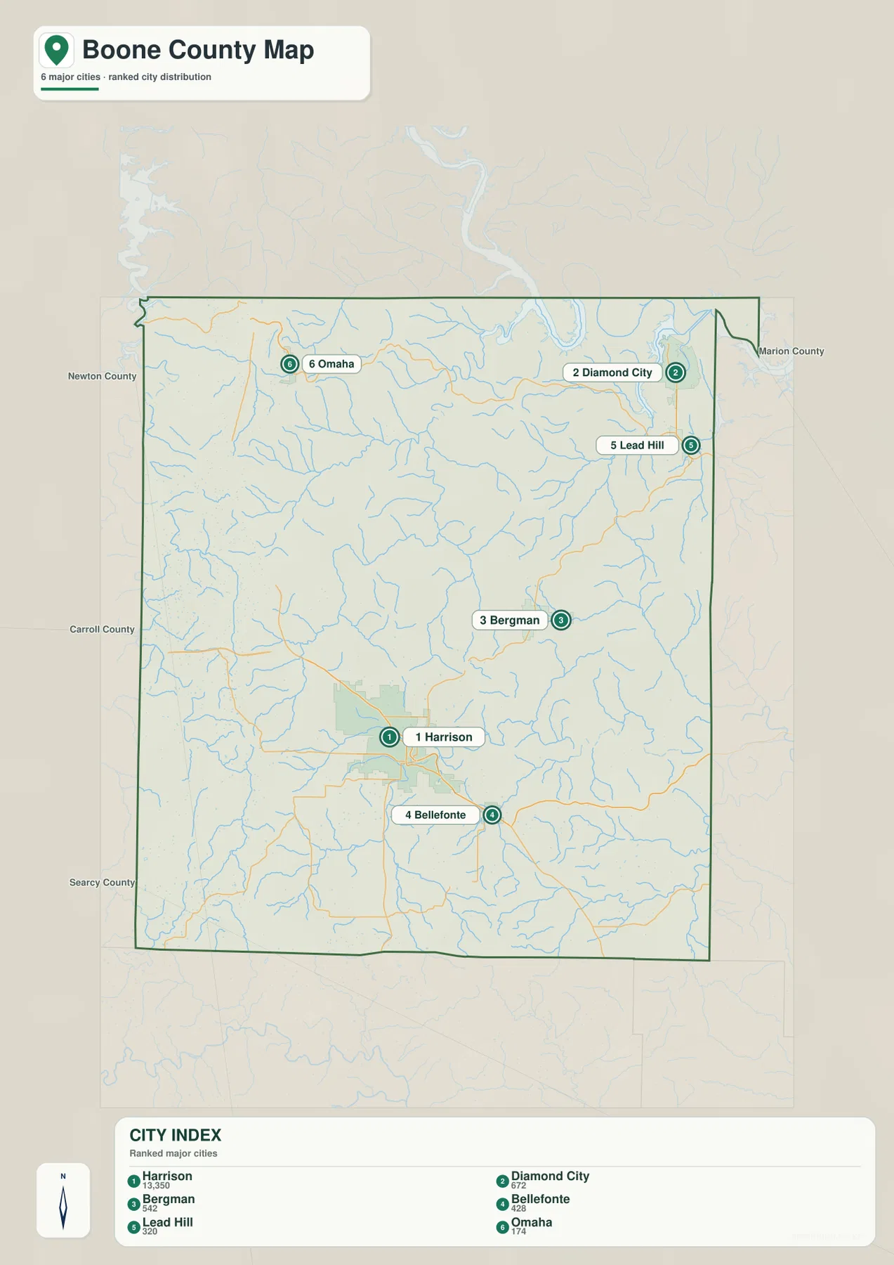
The city map removes much of the road detail and highlights six communities: Harrison, Diamond City, Bergman, Bellefonte, Lead Hill, and Omaha. With fewer labels competing for attention, the spacing between the towns becomes much clearer. Harrison is the dominant center in the south-central part of the county, and Bellefonte lies close by to the southeast. Bergman is farther northeast. Lead Hill and Diamond City sit near the northeastern edge, while Omaha stands apart in the northwest.
That arrangement is more useful than treating all of northern Boone County as one cluster. Omaha belongs to a different direction from Lead Hill and Diamond City, and the road map confirms that distinction. The northeastern towns also make more sense once the water map is added, because Bull Shoals Lake and the White River become major reference features in the same part of the county. The city map therefore works well when a presentation needs a clean overview of settlement locations before adding road or physical-geography detail.
The city index contains ranked values beside the six towns, but those figures should be read as values used for the supplied graphic rather than assumed to be current official population counts. Anyone who needs the latest population should check a current Census release. For this page, the most reliable use of the city image is visual: it shows where the main labeled communities sit in relation to Harrison, one another, and the edges of the county.
Bull Shoals Lake and the White River define the northeast
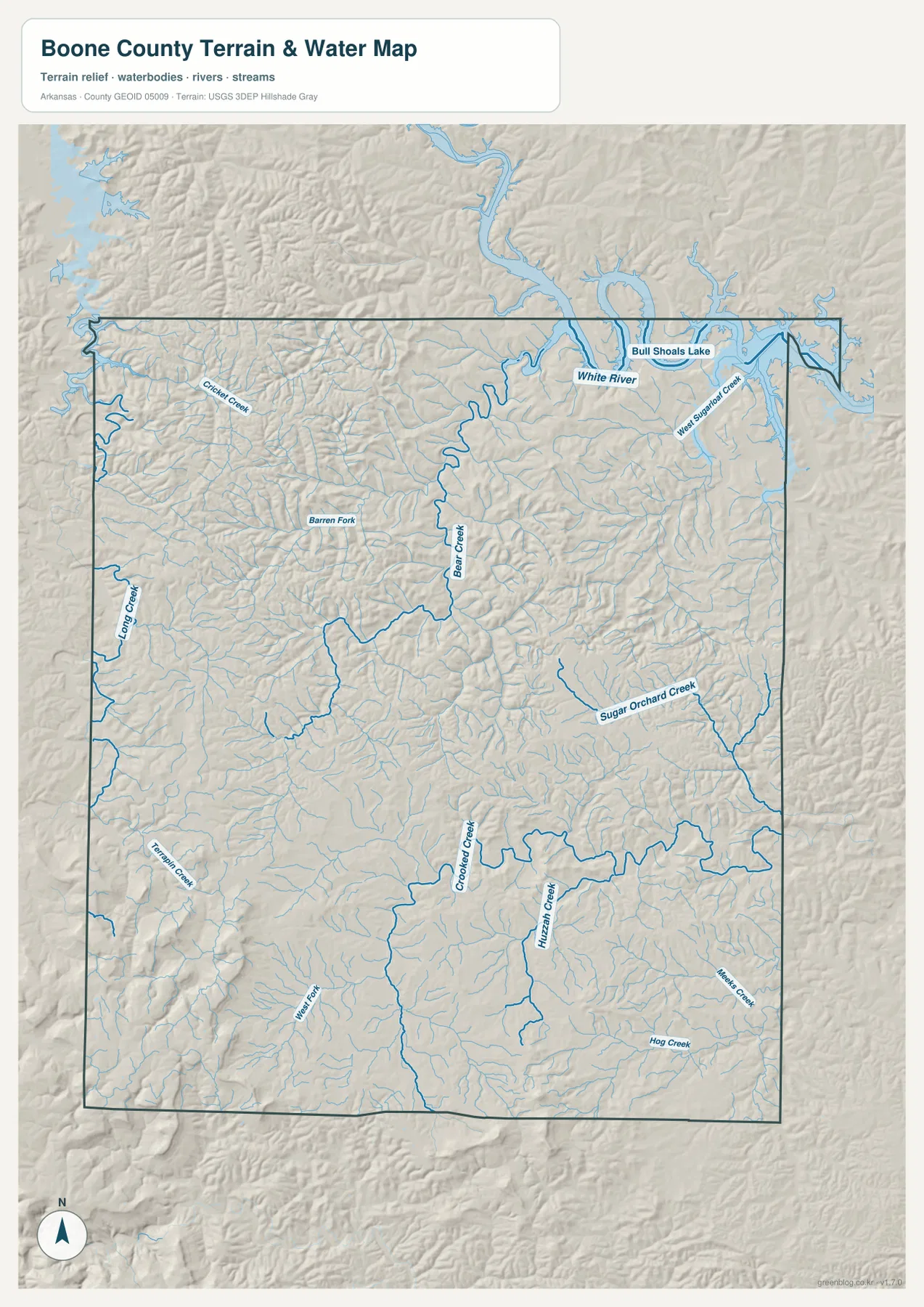
The water-and-terrain image changes the emphasis completely. Bull Shoals Lake is the largest named water feature, touching the northeastern edge of the county area, and the White River runs nearby through a broad low corridor. After locating Diamond City and Lead Hill on the other maps, it is easy to see why those communities are naturally associated with the northeastern water landscape. For a reader interested in the lake, river setting, or physical geography, this image is much easier to use than a road-heavy map.
Several named creeks help explain the interior of Boone County. Bear Creek runs through the north-central area toward the White River system, while Crooked Creek follows a long, winding course across the southern half. Long Creek and Terrapin Creek are labeled on the western side. Sugar Orchard Creek, Huzzah Creek, and Hog Creek appear farther east and southeast, and West Sugarloaf Creek is marked near the northeastern water network. The shaded terrain makes it clear that these streams occupy a landscape of repeated ridges and valleys rather than a broad flat plain.
This map is best used for location and general landscape context. It does not show real-time water levels, boating conditions, flood zones, or parcel-level flood risk. Those questions require current information from the appropriate official service. Here, the useful takeaway is simpler: Bull Shoals Lake and the White River are the major water references in the northeast, while Bear Creek, Crooked Creek, and smaller tributaries cut through the county interior.
The southwest rises well above the river valleys
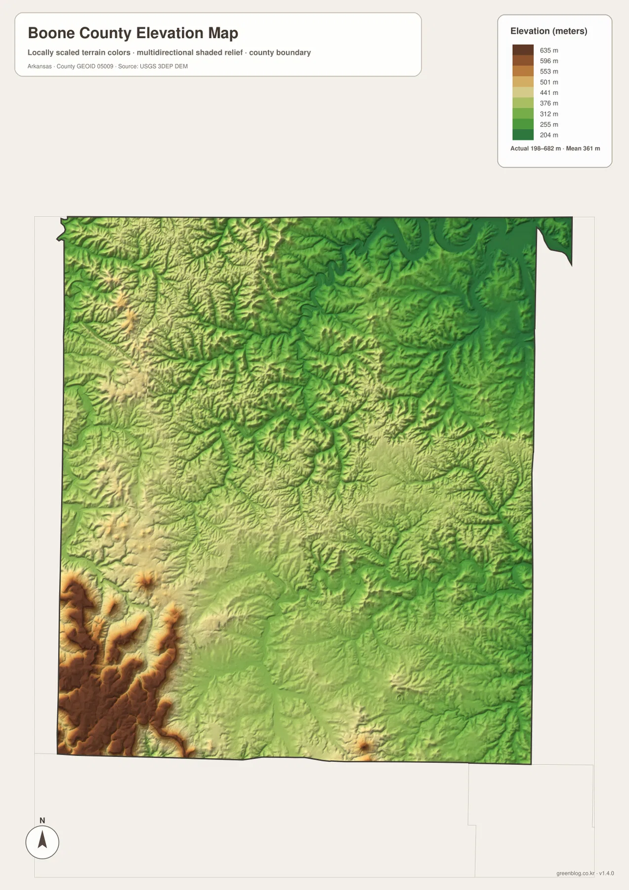
The elevation image shows the strongest countywide contrast. Its legend gives an actual range of roughly 198 to 682 meters, with a mean near 361 meters. The highest colors are concentrated in the southwest, where brown and tan ridges rise sharply above the surrounding terrain. That area is visually different from the north and northeast, where greens cover broad sections around the White River and the lake-side valleys. Even without reading individual contour values, the color difference makes the high southwest and lower northern drainage corridors easy to distinguish.
Harrison occupies more moderate ground between those extremes. The terrain around the city is still uneven, but it does not show the same concentration of high ridges found in the southwest. Moving north and east, lower channels become more common along the stream valleys. Comparing the elevation image with the water map is particularly useful around Bear Creek and Crooked Creek, because the stream courses generally follow lower ground between the surrounding ridges.
The elevation map is designed for broad geographic comparison, not site measurement. A color band cannot establish the exact height of a house lot, road grade, or construction point, and it should not replace survey data. For engineering, drainage design, or property work, original elevation data and professional surveying may be required. On this page, the map is most useful for showing why the southwest looks more rugged and why the major river corridors occupy lower terrain.
Choose the map that matches the question
For a general introduction to Boone County, the county map is the best first choice because it combines Harrison, smaller communities, roads, waterways, and the boundary on one page. The city view is cleaner when the only goal is to compare where the main settlements lie. A lesson or report about Bull Shoals Lake, the White River, or the county’s creeks will benefit more from the water-and-terrain image. When the subject is the high southwest or the lower river corridors, the elevation map adds the missing vertical dimension.
A useful way to combine them is to keep one familiar place on screen while changing the map type. Start at Harrison to compare roads and towns. For the northeast, use Diamond City or Lead Hill as the place anchor, then switch to the water map to bring Bull Shoals Lake and the White River into view. In the southwest, town labels matter less than the strong elevation colors. This approach keeps the explanation focused on the county itself rather than turning the page into a list of map products.
The web images are convenient for quick viewing, but they are not the largest versions. The download package contains the matching A3 high-resolution JPG files and is a better choice when the map will be printed, placed on a larger page, or inserted into a presentation. The files preserve the same four subjects shown above, so readers can choose only the image needed for a particular assignment or keep the full set together.
Frequently Asked Questions
Which map should I use to trace a route from Harrison toward Bull Shoals Lake?
Begin with the general county map because it shows Harrison, Bergman, Lead Hill, Diamond City, and the main roads in one view. Then switch to the water map to see Bull Shoals Lake and the White River more clearly. For actual driving directions, current closures, or travel times, use a live navigation source as well.
Where is the highest terrain shown in Boone County?
The supplied elevation map places the most prominent high terrain in the southwest. The full mapped range is about 198 to 682 meters, and the darkest high-elevation colors are concentrated there. Lower colors are more widespread toward the White River and Bull Shoals Lake in the north and northeast.
Can the water map be used to determine flood risk?
No. It is a general reference for the location of Bull Shoals Lake, the White River, Bear Creek, Crooked Creek, and other streams. It does not contain current river stages, regulatory flood zones, or parcel-level flood information. Flood-risk decisions should use the official product intended for that purpose.
Map File Information
The ZIP contains the A3 high-resolution JPG originals for the Boone County general map, city map, water-and-terrain map, and elevation map. They are intended for larger layouts, classroom materials, documents, presentations, and printing.
- Included Files: Use only the versions confirmed in the article and supplied images
- File Type: Use the confirmed download contents
- Intended Use: Printing, education, presentations, and map-based projects
Related Maps
Sources and reference data
These official sources are useful for checking Boone County administration and the federal geographic datasets behind county boundaries, water features, and elevation. The maps on this page are general visual references and should not replace legal boundary records, live navigation, flood-hazard products, engineering data, or professional land surveys.
- Boone County AR Government – official county administration and Harrison courthouse information
- U.S. Census Bureau TIGER/Line Shapefiles – county boundaries and geographic reference data
- USGS National Hydrography – source information for rivers, lakes, and streams
- USGS 3D Elevation Program – source elevation data and program information
Green Map creates custom-edited map images using open geographic data sources such as geoBoundaries, Natural Earth, OpenStreetMap, and government open data.
These maps are edited visual materials, not raw data files, and are provided for education, documents, presentations, and graphic reference.