Marshall County sits in northeastern South Dakota, and the quickest way to understand its geography is to start with Britton and then look east. Around Britton and Langford, the road network crosses comparatively low, open ground. Farther east, Lake City, Eden, and Veblen sit among a denser mix of small lakes, stream valleys, and higher terrain. This page brings those differences together with four map views, and you can download the high-resolution A3 JPG files in one ZIP for closer study or printing.
The county is especially useful to view as a west-to-east transition rather than as a simple rectangle of roads. Britton functions as the hub on the city-connections map, while Lake City and Eden lie closer to the lake-rich southeast and Veblen occupies the northeastern side where tributaries cut through higher ground. Reading the maps in that order makes it easier to see why roads, settlements, water, and relief do not have the same pattern across the whole county.
Table of Contents
Britton as the western hub, with lake country opening to the east
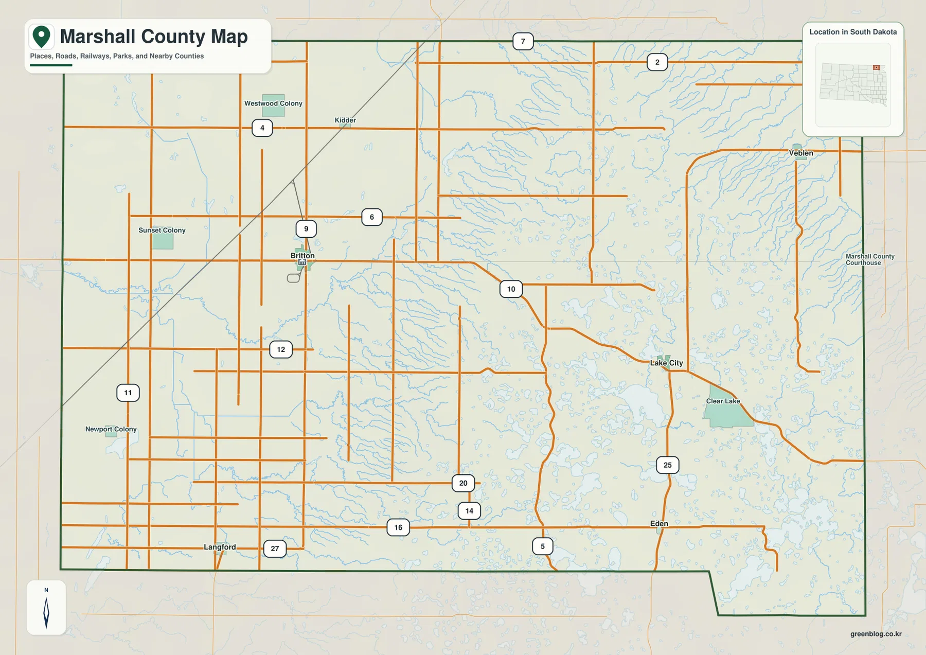
On the general county map, Britton is the clearest orientation point. South Dakota Highway 10 runs east from the Britton area toward Lake City, while routes in the northeast turn toward Veblen. Highway 27 passes Langford in the south, and Highway 25 provides a north-south line through the eastern side near Eden and Veblen. These roads make it possible to understand the settlement pattern before focusing on the smaller streams and lakes.
The western half also contains labels such as Westwood Colony, Sunset Colony, Newport Colony, and Kidder. Moving east from Britton, blue water lines and lake shapes become much more common. Around Lake City and south toward Eden, the map is filled with ponds, lakes, and drainage features that interrupt the otherwise regular road grid. That contrast between the straighter western roads and the more water-dominated eastern landscape is one of the most distinctive features of this county map.
Five communities spread from Britton to Veblen, Eden, Lake City, and Langford
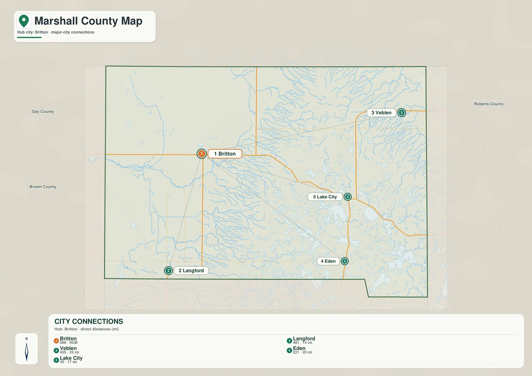
The city-connections map strips away much of the background detail and makes the relative position of the main communities easier to compare. Britton is the hub. Langford lies about 14 miles away in a straight line, Lake City about 17 miles, Eden about 20 miles, and Veblen about 23 miles. These are direct point-to-point distances, not road-mile estimates, so a drive will normally be longer than the number printed on the map.
This arrangement shows a county with two noticeably different sides. Britton and Langford occupy the west and southwest, while Lake City, Eden, and Veblen are set farther east where lakes and stream valleys are more common. The eastbound road from Britton toward Lake City crosses the middle of the county before entering that wetter landscape. The route toward Veblen climbs toward the northeastern uplands, while Langford remains close to the lower western terrain.
Marshall County’s 2025 Pre-Disaster Mitigation Plan also identifies Britton, Eden, Lake City, Langford, and Veblen as incorporated communities. It lists Highway 10 through Britton and Lake City, Highway 27 through Langford, and Highway 25 through the eastern side as major roads. Those official descriptions line up well with the road structure visible in the supplied map, which makes the city view useful for both quick orientation and broader geographic context.
Wild Rice River, Crow Creek, and a dense field of prairie lakes
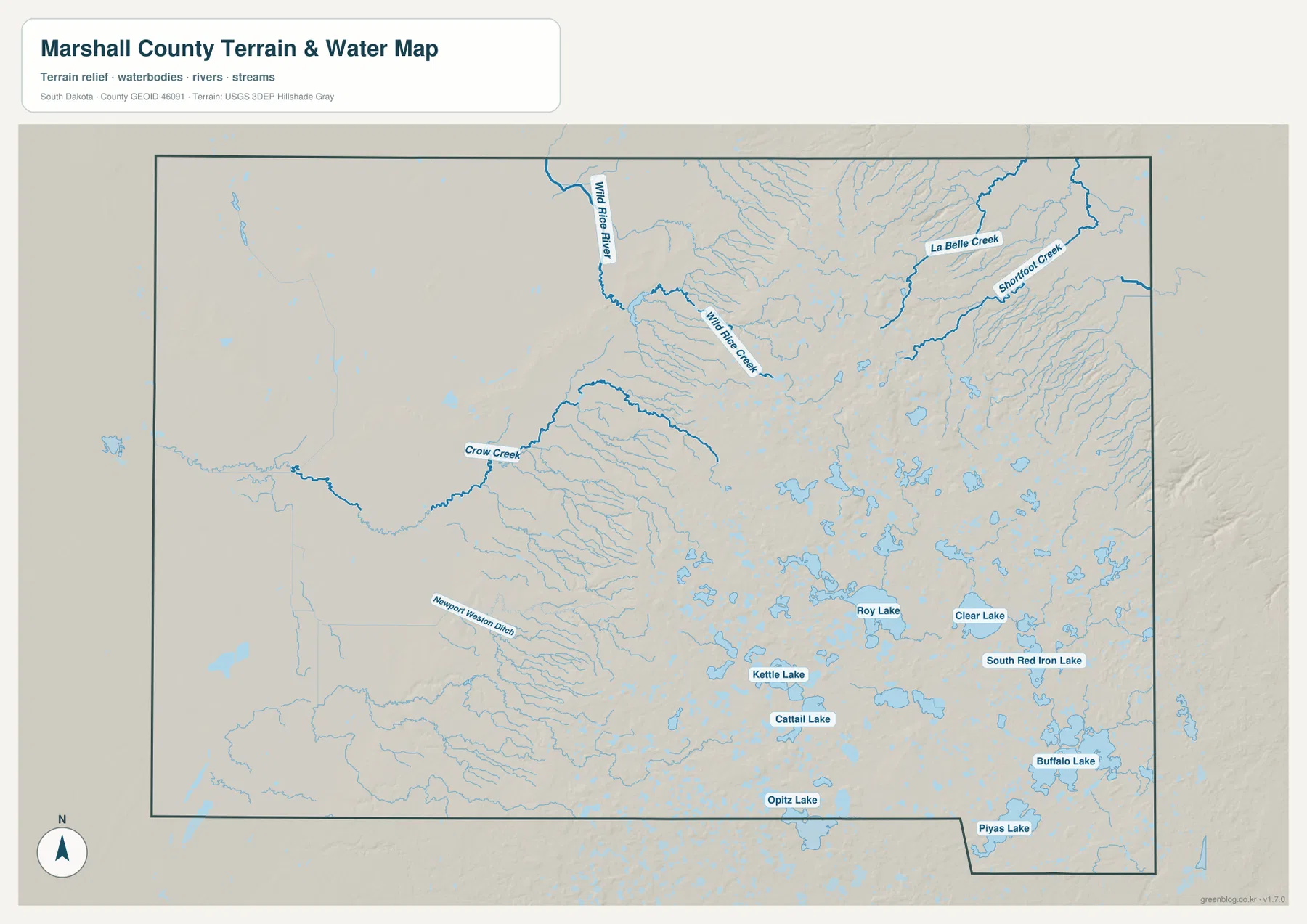
Water becomes the dominant subject on the terrain and water map. Wild Rice River enters near the north side and bends southward, with Wild Rice Creek extending through the north-central area. La Belle Creek and Shortfoot Creek occupy the northeast, while Crow Creek reaches across the western middle of the county. The streams do not form a single parallel pattern; they follow valleys that descend away from the higher eastern ground and spread toward lower areas.
Named lakes are concentrated most heavily across the central-southern and southeastern part of the county. Kettle Lake, Cattail Lake, Opitz Lake, Roy Lake, Clear Lake, South Red Iron Lake, Buffalo Lake, and Piyas Lake are all labeled, with many smaller water bodies surrounding them. That concentration explains why the general map around Lake City and Eden looks so much more water-filled than the western side around Britton and Langford.
The water map also labels Newport Weston Ditch in the west. It is best treated as a mapped drainage feature rather than assumed to be the same kind of natural channel as a river or creek. More broadly, this map is for locating water bodies and drainage features; it is not a flood-risk map, parcel map, navigation chart, or statement about legal access. Anyone making a safety, property, or engineering decision should consult the appropriate current official dataset for that purpose.
A sharp rise from the western lowlands into the eastern uplands
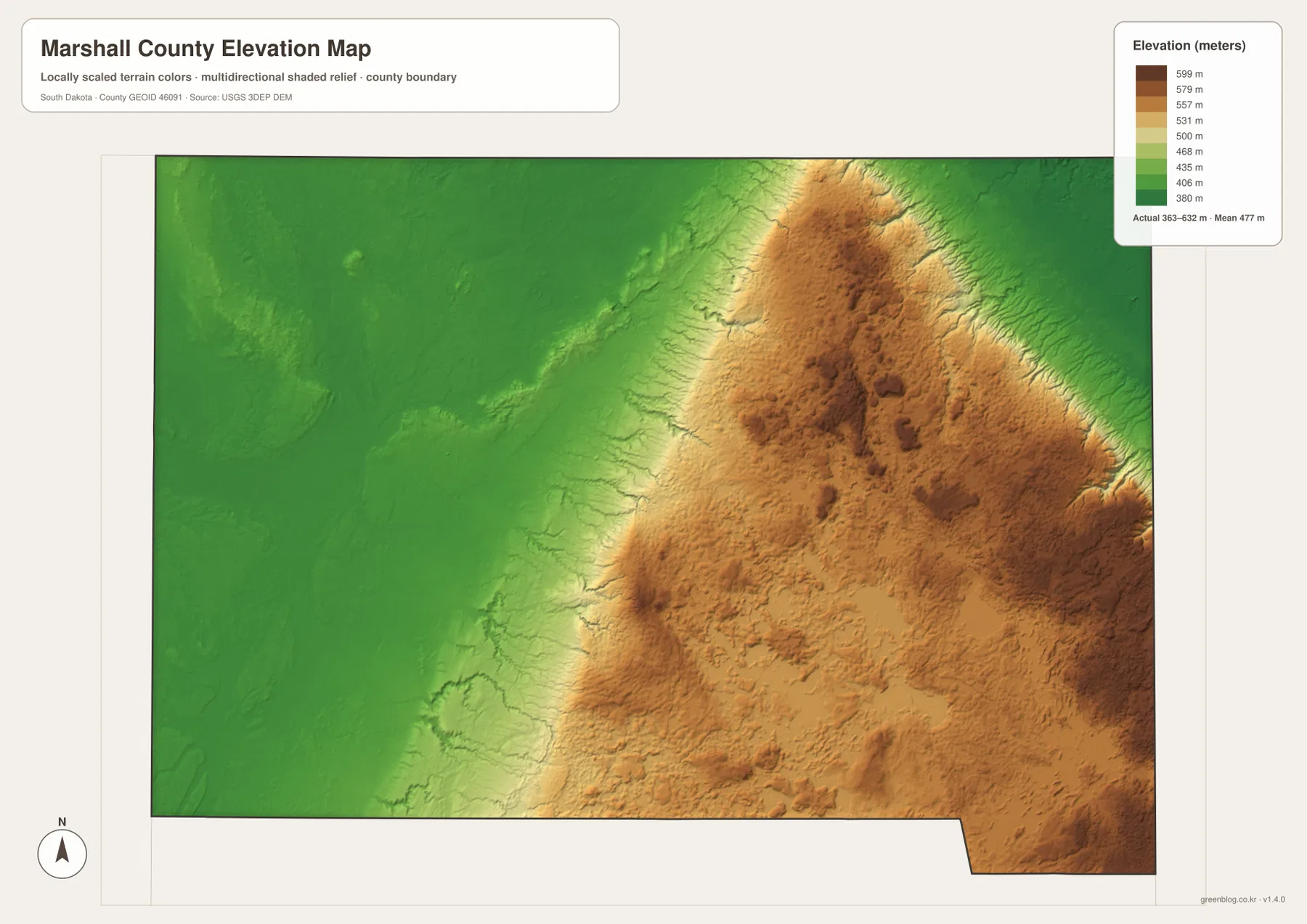
The elevation map reveals a stronger west-east contrast than the road map alone suggests. The legend gives an actual range of roughly 363 to 632 meters, with a mean near 477 meters. Dark green dominates much of the western half, indicating lower, gentler ground, while the colors shift quickly into light green, tan, and brown toward the east.
The highest terrain is concentrated through the northeast and eastern side. West and northwest of Veblen, the surface rises into deeply cut uplands. Higher colors also continue southeast of Lake City and east of Eden. Wild Rice River, La Belle Creek, Shortfoot Creek, and numerous smaller channels carve into this higher terrain, so the eastern side is not a smooth plateau; it is a dissected landscape of ridges and valleys.
Britton and Langford, by contrast, sit much closer to the lower western terrain where elevation changes are more gradual. That helps explain why the western road network appears more regular and why eastern roads more often bend around water and broken ground. The elevation surface is a generalized visualization rather than survey-grade measurement, so detailed construction, drainage, or engineering work should use the original USGS elevation data or site-specific surveying.
Which Marshall County map should you open first?
For a fast check of towns, roads, and county boundaries, the general map is the best starting point. It shows the named communities, numbered highways, nearby county context, rail lines, and other reference features together. If the main question is how Britton relates to Langford, Lake City, Eden, and Veblen, the city-connections map is cleaner because it reduces the background and emphasizes relative direction and direct distance.
The water map is the better choice when the goal is to find Wild Rice River, Crow Creek, the northeastern tributaries, or the many lakes around the southeast. The elevation map adds the missing vertical context by showing why those eastern drainage networks sit in a more strongly dissected upland while the west remains lower. You do not need every map for every task, but using the four together makes the relationship among settlement, roads, water, and relief much easier to understand.
Frequently Asked Questions
Are the distances from Britton to Veblen, Lake City, Eden, and Langford driving distances?
No. The city-connections map labels direct straight-line distances: about 14 miles to Langford, 17 miles to Lake City, 20 miles to Eden, and 23 miles to Veblen. Actual road travel will usually be longer because routes follow the highway network rather than a straight line.
Why does eastern Marshall County look more broken up by streams and lakes?
The elevation map shows the eastern side rising to roughly 632 meters, while much of the west is substantially lower. Wild Rice River and several tributaries cut through that higher ground, and the central-southeastern part of the county also contains a dense group of lakes. Together, those features create a more complex pattern than the low western side.
What is included in the downloadable map ZIP?
The archive contains four high-resolution JPG files: the general county map, city-connections map, terrain and water map, and elevation map. Each original image is 3638 × 2572 pixels and is suitable for A3 printing or closer on-screen review.
Map File Information
The ZIP contains one high-resolution JPG for each supplied view: the county map, city-connections map, terrain and water map, and elevation map. The original JPG files are sized for A3 printing and preserve more label and boundary detail than the web previews.
- File Type: 4 JPG files + 1 ZIP archive
Related Maps
Sources and references
County road and community context can be checked in the Marshall County 2025 Pre-Disaster Mitigation Plan. Core mapping references include the U.S. Census Bureau TIGER/Line Shapefiles for boundaries and roads, USGS National Hydrography for water features, and the USGS 3D Elevation Program for elevation data.
Green Map creates custom-edited map images using open geographic data sources such as geoBoundaries, Natural Earth, OpenStreetMap, and government open data.
These maps are edited visual materials, not raw data files, and are provided for education, documents, presentations, and graphic reference.