You can download four high-resolution JPG maps of Hyde County, South Dakota from this page in one ZIP file. The article also includes lighter WebP previews for quick viewing: a detailed road-and-place map, a simplified city distribution map, a terrain and water map, and an elevation map. Together they make it easy to locate Highmore near the middle of the county, compare the northern prairie lakes with the denser creek network in the south, and see broad relief from about 433 to 673 meters.
Hyde County has a long north-south outline, and Highmore sits close to the point where the western boundary steps inward. That makes the town a useful visual anchor. North of Highmore, the road network spreads across a broad rectangular section with many small drainage lines and lakes. South of town, the county narrows before opening into higher, more strongly shaded terrain cut by Chapelle Creek, Elm Creek, and other tributaries.
Table of Contents
Highmore anchors the road map between the northern and southern halves
The detailed county map places Highmore along the strong east-west road labeled 14, just below the point where the western county line moves inward. Holabird appears west of Highmore on the same corridor, while Macs Corner is farther south near road 34. The north is crossed by numbered roads such as 645, 960, 26, and 154, with additional north-south routes including 648, 649, and 775. South of Highmore, labels such as 959, 45, 47, 961, and 776 help divide the lower part of the county into recognizable sections.
The map also shows many small streams crossing the road grid. In the northern half, the roads are relatively easy to follow because the county outline is wide and rectangular. The southern half feels different: the boundary is narrower at first, then extends through an area with more visible drainage lines and curving terrain. Reading the map from Highmore outward is more useful than trying to memorize every road number at once.
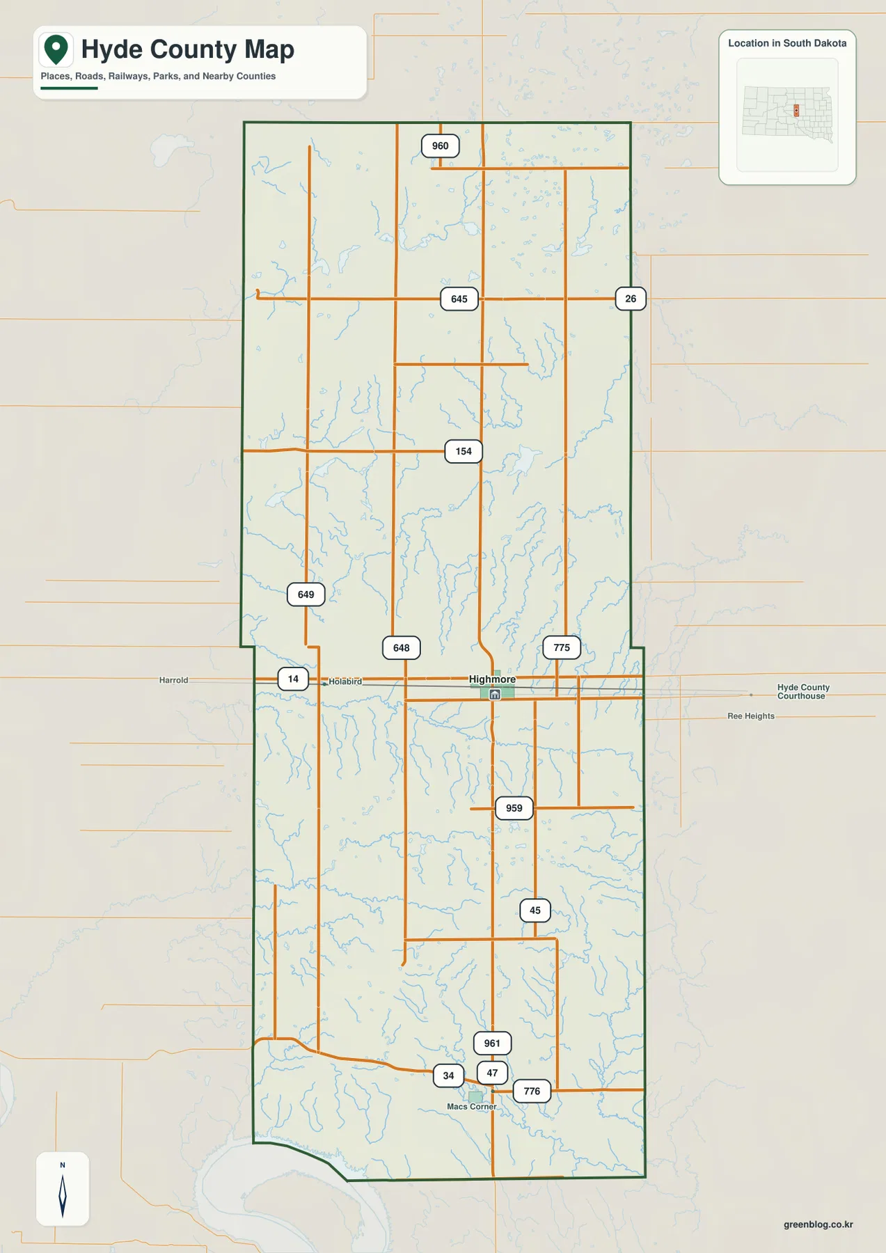
Nearby labels outside the boundary, including Harrold and Ree Heights, help with regional orientation. The map is still a static reference image rather than a navigation service. It does not report current road closures, construction, surface conditions, or driving times, so those details should be checked with a current transportation or mapping service before travel.
The city view highlights Highmore without inventing distance comparisons
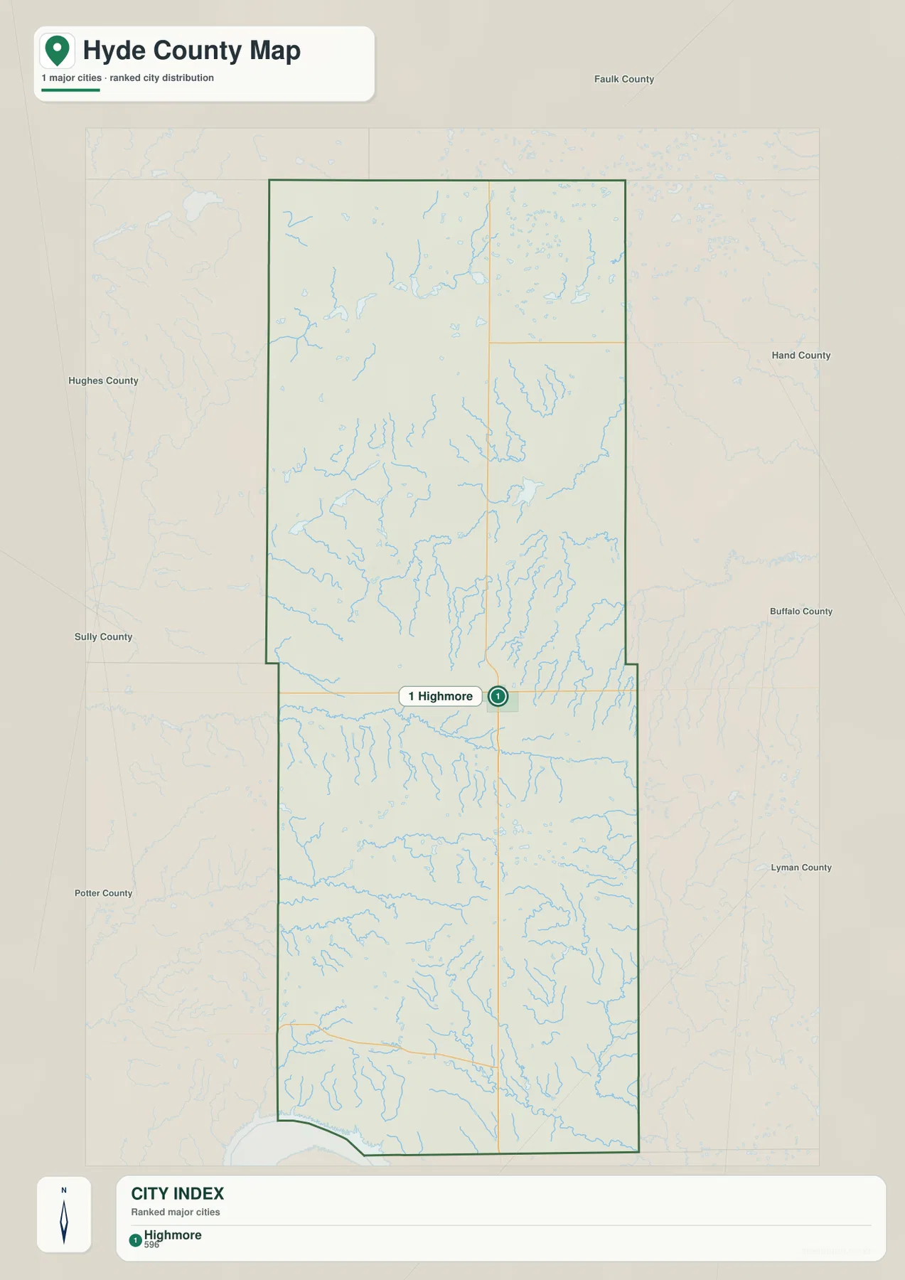
The city distribution map is unusually simple because it highlights only one ranked major city: Highmore. The green marker sits slightly below the middle of the county. Around the outside, labels for Faulk, Hand, Buffalo, Lyman, Potter, Sully, and Hughes counties provide a useful frame, making it easier to see how Hyde County fits into central South Dakota without the road detail of the first map.
No connector lines or mileage values are printed on this city map. It should not be treated like the distance-index maps used for some other counties. Its purpose here is to show Highmore’s relative position and the neighboring counties around Hyde. A South Dakota state profile published in 2007 described Highmore as Hyde County’s only organized community, which is consistent with the supplied city index giving Highmore the sole ranked marker.
Highmore is also important for county government and local history. A National Register nomination identifies the Hyde County Courthouse in Highmore, while the Hyde County Historical and Genealogical Society preserves materials related to the county and the city. Those references are useful when the map is being used to plan a visit, but the city map itself should remain a geographic orientation tool rather than a directory of offices or opening hours.
Prairie lakes dominate the north while named creeks become stronger in the south
The terrain and water map gives the northern half a lake-centered character. Spring Lake is labeled in the northwest, Thomas Lake sits farther east near the upper middle, and Rezac Lake is in the northeast. Mitchell Lake and Lake Douglas appear below them. Numerous short blue drainage lines surround these named lakes, so the upper part of the county is easier to recognize by scattered water bodies than by one dominant river.
South of the county’s midpoint, the named streams become more prominent. South Fork Medicine Knoll Creek crosses the upper part of the southern section. Farther down, Chapelle Lake lies beside Chapelle Creek, with South Chapelle Creek and Chapelle Rush Creek in the same general area. On the southeast side, Elm Creek and West Fork Elm Creek form another visible drainage system. Lake Ambrose is labeled near the lower center-east, close to the lower creek network.
Wolf Creek is another strong label on the east-central side. Taken together, the map shows a useful north-south contrast: several named lakes and shorter channels in the north, followed by a more obvious network of named creeks in the south. That pattern helps readers match the water map with the elevation map, where many of the stream corridors appear as lower green cuts through higher terrain.
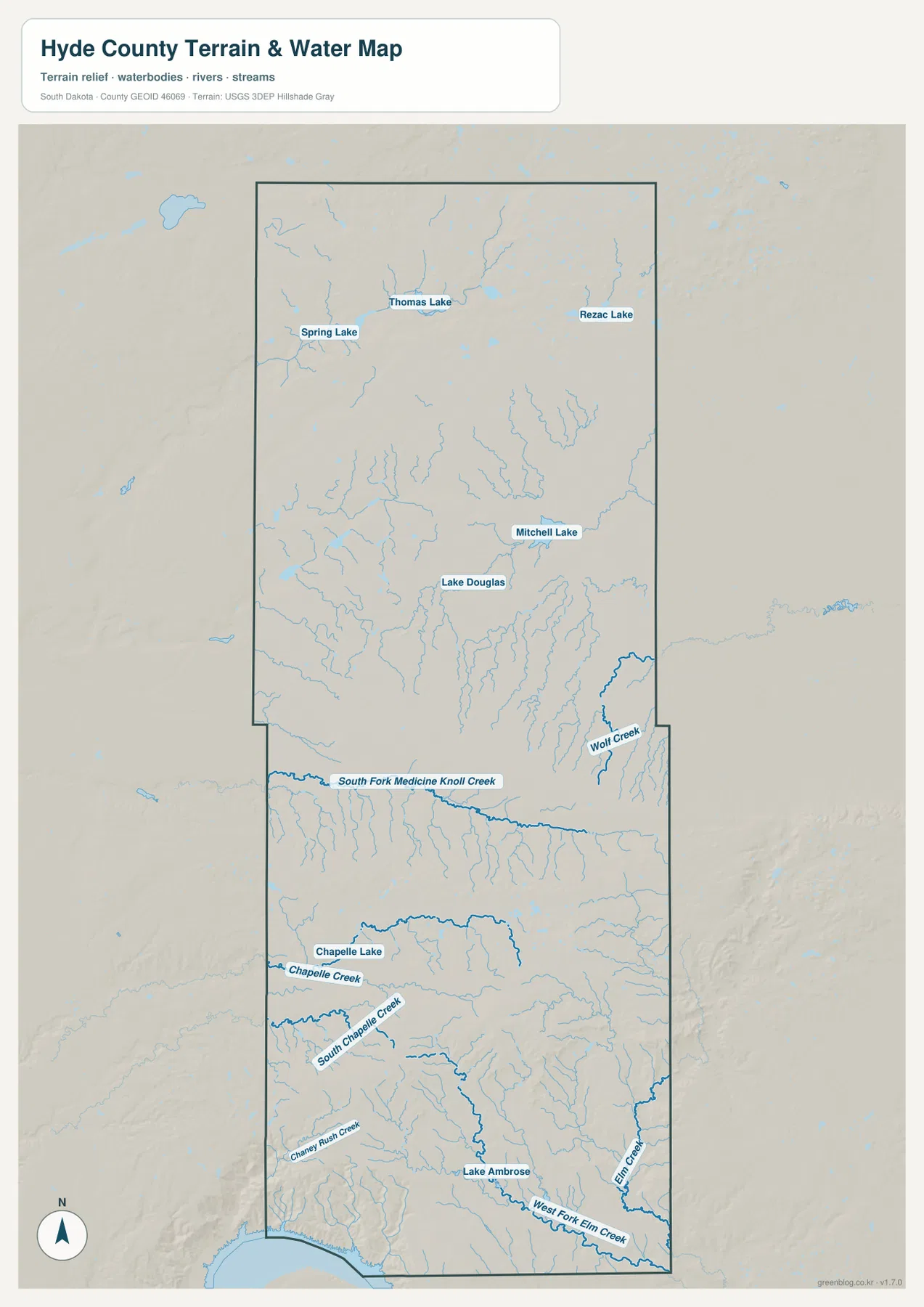
This is a geographic water-reference map, not a flood, drainage-permit, or navigation product. Stream width and flow can change with season and rainfall, and smaller channels are generalized at this scale. Use it to identify named water features and compare their broad positions. Flood risk, engineering drainage, legal water boundaries, and other safety-critical questions require the appropriate current official data.
Elevation ranges from about 433 to 673 meters with strong southern uplands
The elevation legend reports an actual county range of roughly 433 to 673 meters and a mean of about 565 meters. Much of the middle of Hyde County is green, indicating lower ground relative to the rest of the county. The northwest has a band of yellow and brown higher terrain, but the northern section is not uniformly high; lower green areas extend across much of the northeast and central part of the upper county.
The strongest relief appears in the southern half. Orange and brown uplands spread across the middle-south, with darker high areas surrounded by narrow green valleys. These valleys correspond well with the creek-rich landscape shown on the water map. South Fork Medicine Knoll Creek, the Chapelle Creek system, and the Elm Creek system make more sense when viewed against this broad elevation surface because the channels occupy lower cuts between higher ridges and rolling ground.
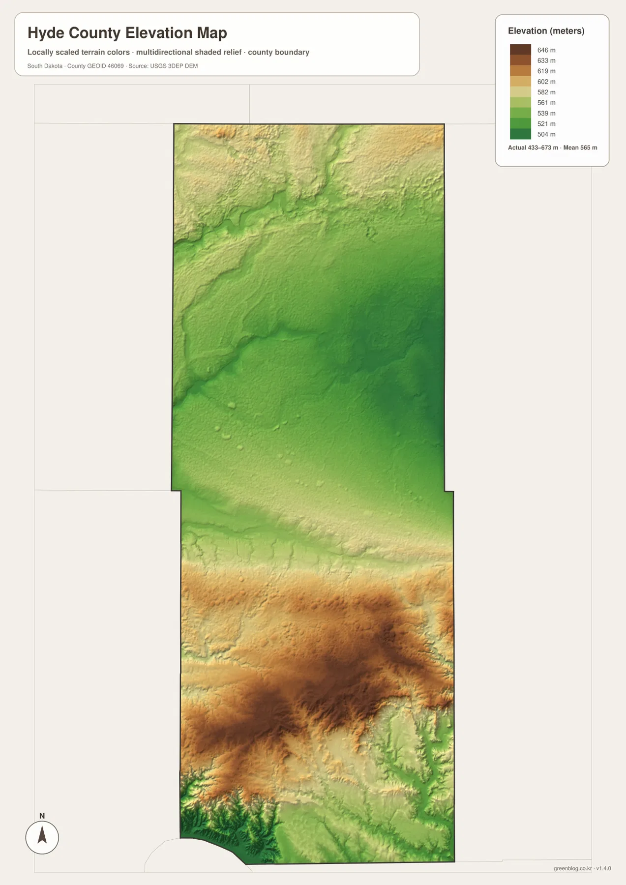
The far southern edge returns to lower green terrain in places, so the county does not simply rise from north to south. A better description is a mix of broad lower basins and higher ridges, with the most pronounced high ground concentrated in the southern interior and another elevated area in the northwest. This generalized surface is appropriate for county-scale comparison but not for survey-grade elevation at a parcel, building site, road cut, or drainage structure.
Choose the map by whether you need roads, water names, or broad relief
Use the detailed county map when the task is to locate Highmore, Holabird, Macs Corner, or numbered roads such as 14, 34, 45, and 47. The city map is cleaner when the only question is where Highmore sits within Hyde County and how the county relates to its neighbors. Because the city version has no distance connectors, it should not be used to estimate mileage.
For Spring Lake, Thomas Lake, Rezac Lake, Lake Douglas, Chapelle Creek, Elm Creek, and Lake Ambrose, the terrain and water map is the better starting point. Then compare the same area on the elevation map to see whether a stream lies in a lower corridor or between higher ridges. If relief is the main interest, reverse the order: begin with the 433–673 m elevation range and then return to the water map for feature names.
The WebP images in the article are reduced previews designed for fast viewing. For A3 printing, presentations, classroom use, or closer inspection of small labels, the original JPG files are more useful. The ZIP below contains the same four maps as high-resolution JPGs, each measuring 2572 × 3638 pixels.
Frequently Asked Questions
Does the city map give distances from Highmore to other communities?
No. Highmore is the only ranked major city shown on this version, and the map has no connector lines or mileage values. Use it for relative location and neighboring-county orientation rather than straight-line or driving distance.
Can the creek and lake map be used to determine flood risk?
No. It is a county-scale reference for locating water features such as Spring Lake, Chapelle Creek, Elm Creek, and Lake Ambrose. Flood levels, drainage permits, and property-specific risk should be checked with current official hydrology and flood-hazard data.
Is the 433–673 meter elevation range accurate for a specific parcel?
No. The legend summarizes broad county relief, and the shaded surface is generalized for map viewing. Parcel, construction, drainage, or engineering work requires more precise elevation data and, where appropriate, field surveying.
Map File Information
The ZIP contains four original high-resolution JPG maps of Hyde County: the road-and-place map, city distribution map, terrain and water map, and elevation map.
- Included Files: 4 JPG maps
- Printable Size: 2572 × 3638 px each
Related Maps
Sources and references
- South Dakota – Hyde County: Agriculturally Based – a state profile of Hyde County and Highmore.
- Hyde County Historical and Genealogical Society – local historical information and preservation resources in Highmore.
- National Register – Hyde County Courthouse – National Park Service documentation for the historic courthouse in Highmore.
- U.S. Census Bureau TIGER/Line Shapefiles – official geographic reference data for county boundaries, roads, and place features.
- USGS National Hydrography – official hydrography resources for streams, lakes, and related water features.
- USGS 3D Elevation Program – official U.S. elevation data and 3DEP information.
Green Map creates custom-edited map images using open geographic data sources such as geoBoundaries, Natural Earth, OpenStreetMap, and government open data.
These maps are edited visual materials, not raw data files, and are provided for education, documents, presentations, and graphic reference.