Download the high-resolution Dewey County South Dakota Map JPG files from the ZIP on this page. Eagle Butte is the easiest place to begin, with US 212 running through the southwestern part of the county before continuing east toward La Plant and Swift Bird. Green Grass and Whitehorse provide useful interior references, while the water map shows the Moreau River crossing the county and a broad low corridor along the eastern side. The supplied elevation map reports an actual range of 467 to 749 meters, with much higher terrain in the west than along the eastern drainages.
Dewey County is best understood by combining its long road distances with its river valleys. US 212 organizes much of the southern settlement pattern, but the Moreau River and Little Moreau River explain the interior terrain more clearly. High western uplands are cut by numerous creeks and valleys, and those drainage lines lead toward lower ground in the east. Using Eagle Butte as a starting point makes it easier to connect the road, city, water, and relief views without turning the page into four separate inventories.
Table of Contents
Eagle Butte and US 212 provide the clearest road reference
The general county map places Eagle Butte near the southwestern side of Dewey County. US 212 approaches from the Lantry area, passes Eagle Butte, and continues east toward La Plant and Swift Bird. North Eagle Butte is labeled separately just above the main Eagle Butte area. SD 65 follows the western side, while route markers 20 and 63 appear farther north, helping define the county’s long north-south extent.
Green Grass lies northwest of Eagle Butte, and Whitehorse is farther into the northern interior. La Plant sits near the middle-eastern section of the US 212 corridor, while Swift Bird is close to the irregular eastern edge. These place names are useful because large parts of the county contain few settlement labels. The general map is intended for geographic orientation rather than live navigation, so current road conditions and travel times should be checked separately.
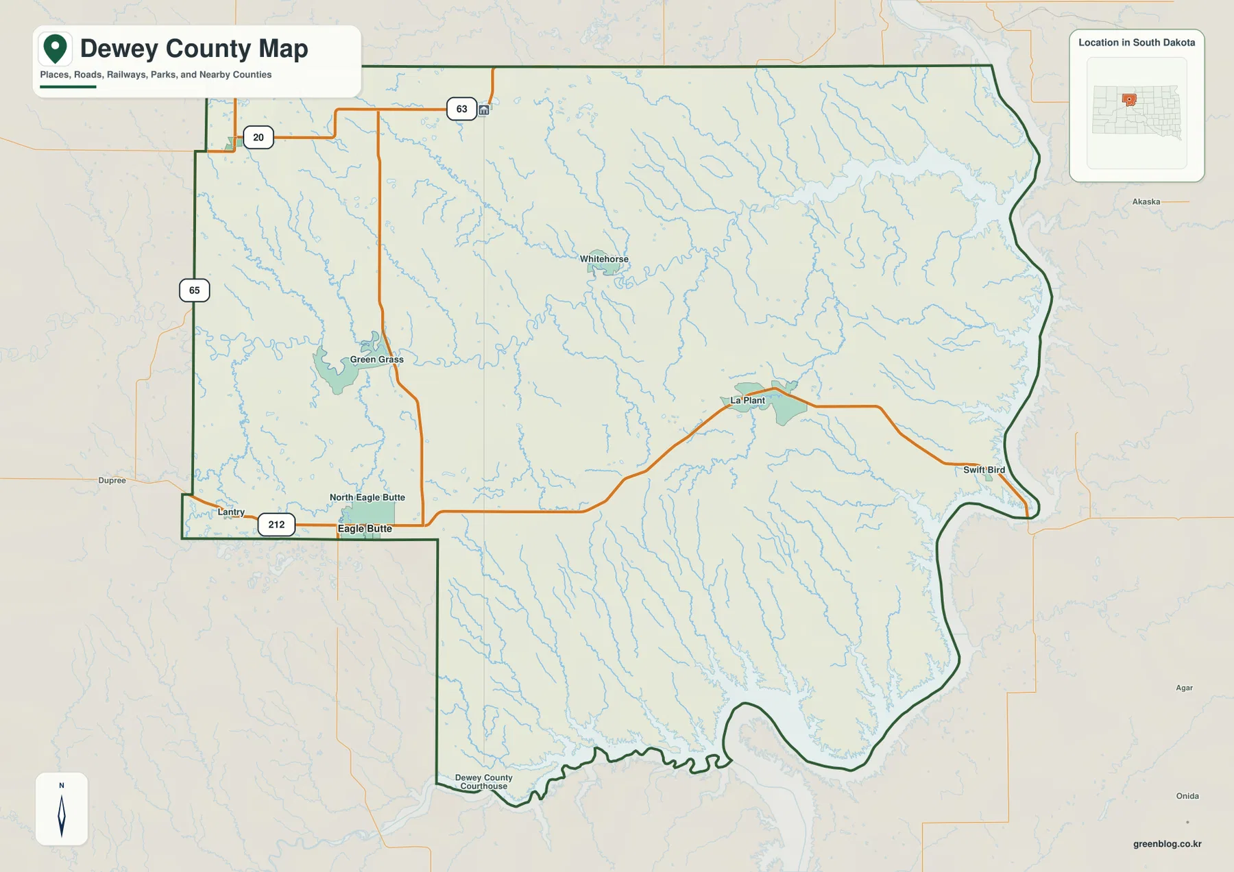
The county’s eastern and southern edges are noticeably irregular because several sections follow water-shaped terrain rather than a simple straight line. This becomes clearer on the water and elevation maps, where low river corridors approach the boundary. The road map gives the best first look at the settlements, while the other views explain the land between them.
Eagle Butte also has a county-specific administrative and tribal role. The Cheyenne River Sioux Tribe lists its tribal government offices in Eagle Butte, and the U.S. Bureau of Indian Affairs lists the Cheyenne River Agency on US Highway 212 in Eagle Butte. Those official sources reinforce the importance of the same place that stands out on the supplied road map.
Eagle Butte is the hub for the Timber Lake and Isabel connection diagram
The city-connections image uses Eagle Butte as the hub. Timber Lake is shown to the north at about 31 miles, while Isabel is northwest at about 29 miles. The graphic labels these as direct distances, so they should be read as straight-line measurements rather than driving mileage. Actual road distance and travel time can be longer depending on the route.
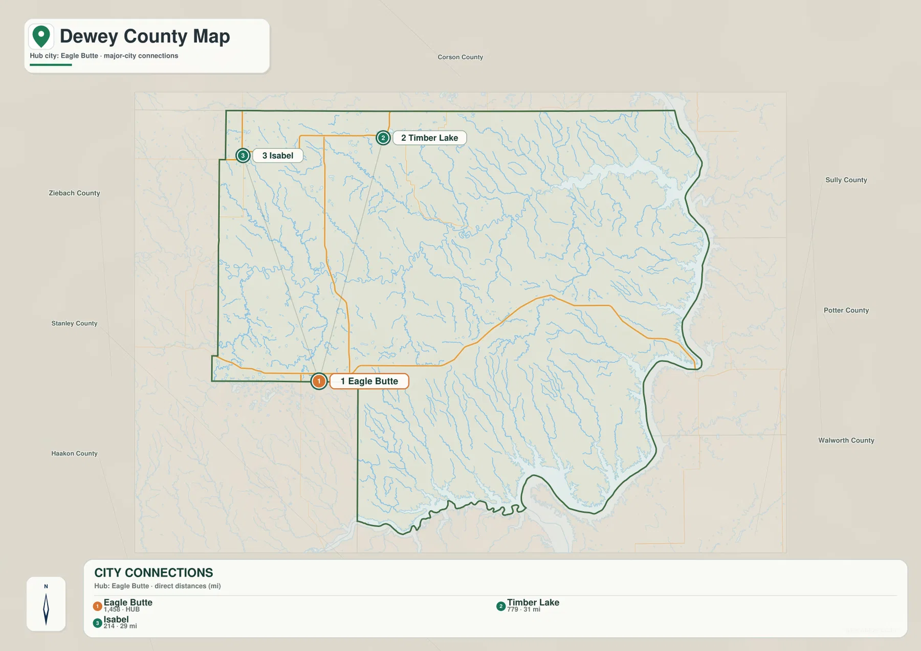
The CITY CONNECTIONS index also prints Eagle Butte 1,458, Timber Lake 779, and Isabel 214. This article treats those figures only as values printed on the supplied image, not as current population estimates. Current population should be verified separately with the U.S. Census Bureau when it matters.
The connection diagram simplifies the road network, so it is best used for relative position. For actual travel between Eagle Butte, Timber Lake, and Isabel, return to the general county map for road context and use a current navigation source for mileage and time.
The Moreau River system organizes the interior of the county
The terrain-and-water map makes the Moreau River the strongest natural reference across central Dewey County. It enters from the west, bends repeatedly through the interior, and continues toward the lower eastern side. The Little Moreau River runs farther north, with Isabel Lake, Peach Lake, and Little Moreau Lake adding separate water landmarks in the western and north-central parts of the county.
Red Earth Creek approaches the Moreau system from the northwest, while Green Grass Creek crosses the southwestern interior. Farther east, Virgin River and Virgin Creek form prominent north-south drainage lines. Rousseau Creek is labeled in the southern portion of the county. Whitehorse Lake and Swan Lake provide additional central references where the creek network becomes especially dense.
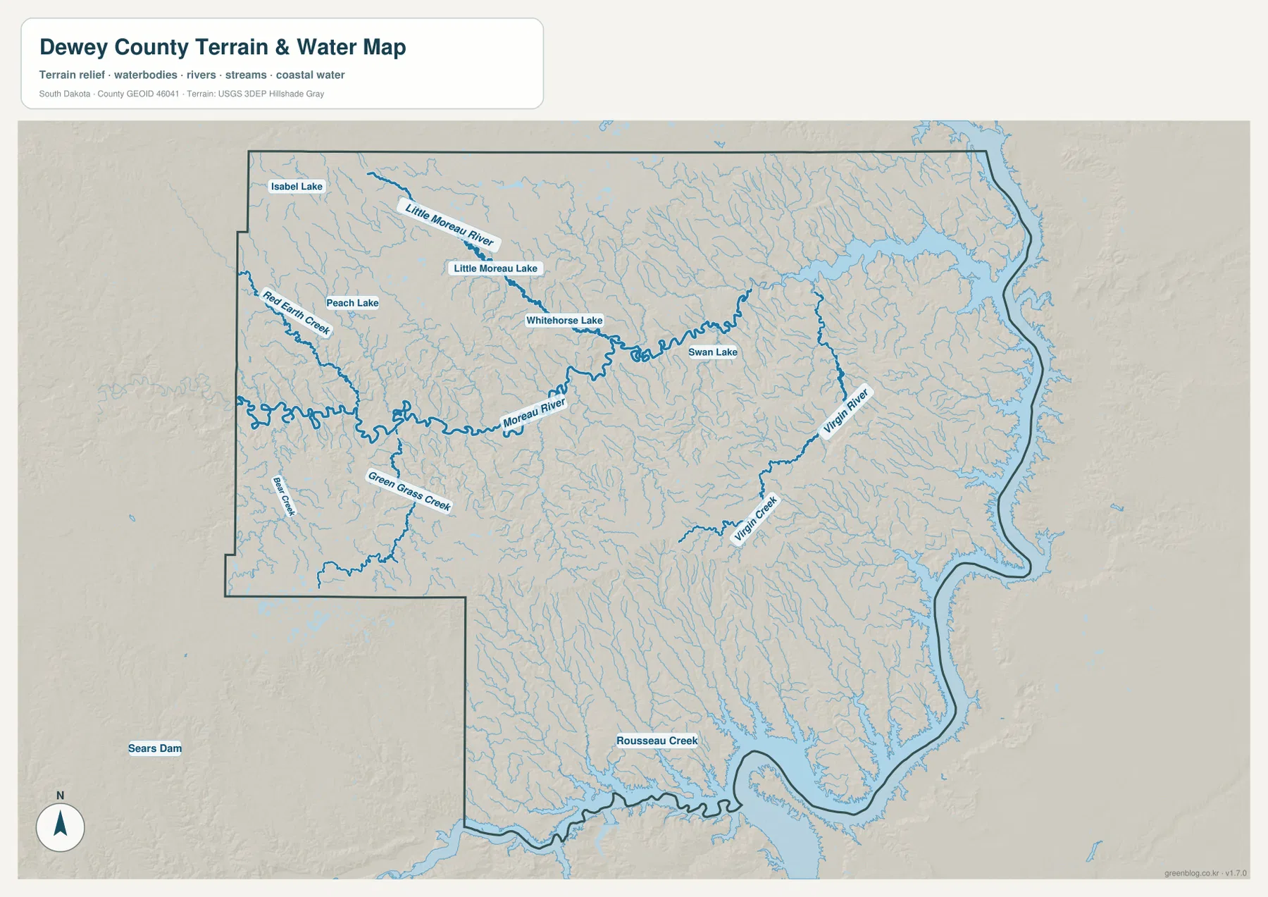
A broad water corridor occupies much of the eastern boundary even though the preview does not place a large name directly on it. Several tributaries and low valleys approach this eastern water edge, and the elevation map shows the same area in deep green. The western side is very different: lakes and streams are surrounded by higher uplands and more strongly cut terrain.
This is a location-reference water map, not a live hydrologic product. It does not report current lake level, streamflow, flood risk, water quality, fishing conditions, or boating safety. Current field conditions should be checked with USGS or local authorities.
Elevation falls from western uplands toward the eastern river country
The elevation map reports an actual Dewey County range of 467 to 749 meters and a mean of 607 meters. Browns dominate much of the west and northwest, indicating the county’s highest broad terrain. Moving into the center, the surface shifts through yellow and light green. The eastern side and northeastern drainages are much greener, marking a substantial drop in elevation.
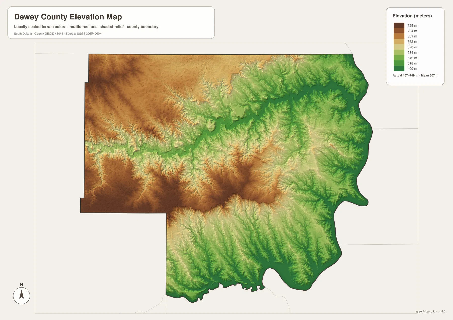
The Moreau River can be followed as a lower winding corridor through otherwise higher terrain. Tributary valleys cut into the western uplands, and the eastern half contains wider green lowlands around the larger drainage network. The southwestern uplands remain strongly elevated, but numerous streams create lower cuts through them rather than leaving one continuous plateau.
The county does not descend in one smooth slope. Higher ridges remain in the center, and smaller uplands are mixed into the eastern half. The 467–749 meter range is therefore most useful when read with the shaded surface. It is suitable for county-scale comparison, not parcel, building, or engineering measurement. A location-specific elevation should be checked with detailed USGS 3DEP data or professional survey information.
Follow Eagle Butte eastward to connect roads, rivers, and relief
Eagle Butte works well as a cross-map anchor. The road map ties it to US 212 and North Eagle Butte, while the city-connections view shows the relative positions of Timber Lake and Isabel. The water map then reveals the Moreau River and tributaries crossing the county, and the elevation surface shows the broad descent from higher western country toward lower eastern drainages.
The other named places create useful regional comparisons. Green Grass and Isabel connect with the higher western terrain, while La Plant and Swift Bird are closer to the lower eastern side. Whitehorse provides a central-northern reference among a dense creek network. Following one place across roads, water, and relief is much clearer than memorizing separate lists of map features.
The ZIP below contains the general county, city-connections, terrain-and-water, and elevation maps as original high-resolution JPG files. Each image is 3638 × 2572 pixels and is suitable for printing, classroom handouts, presentations, or close viewing. Legal boundaries, live road conditions, current water information, flood decisions, and survey-grade elevation require current authoritative data in addition to these reference maps.
Frequently Asked Questions
Are the 31 miles to Timber Lake and 29 miles to Isabel driving distances?
No. The city-connections image labels them as direct distances from Eagle Butte, so they should be read as straight-line measurements. Actual driving mileage and travel time depend on the road route.
Can the Moreau River and Little Moreau River be seen on the same water map?
Yes. The terrain-and-water view shows the Moreau River across the central county and the Little Moreau River farther north. Red Earth Creek, Green Grass Creek, Virgin River, and several named lakes are also visible.
Can the 467–749 meter range be used as the exact elevation of a property?
No. The range is useful for broad county-scale comparison. A property-specific or engineering elevation should be checked with detailed USGS 3DEP data or professional survey information.
Map File Information
The Dewey County general, city-connections, terrain-and-water, and elevation views are packaged as high-resolution JPG files.
- Included Files: Use only the versions confirmed in the article and supplied images
- File Type: Use the confirmed download contents
- Intended Use: Printing, education, presentations, and map-based projects
Related Maps
Sources and References
The article is based first on the names, roads, water features, and elevation values visible in the supplied Dewey County maps. These official sources provide additional county, tribal, boundary, hydrography, and elevation reference information.
- Dewey County official website
- Cheyenne River Sioux Tribe official website
- U.S. Bureau of Indian Affairs – Cheyenne River Agency
- U.S. Census Bureau TIGER/Line Shapefiles
- USGS National Hydrography
- USGS 3D Elevation Program
Green Map creates custom-edited map images using open geographic data sources such as geoBoundaries, Natural Earth, OpenStreetMap, and government open data.
These maps are edited visual materials, not raw data files, and are provided for education, documents, presentations, and graphic reference.