High-resolution JPG map files for Campbell County, South Dakota, can be downloaded from this page after you review the county views below. The map is easiest to orient by using Herreid near the north-central part of the county and Lake Oahe along the irregular western edge. SD 83 runs through Herreid and Mound City, SD 10 crosses the middle from west to east, and SD 271 gives Artas a clear road reference on the east side. Pollock sits in the northwest, so the four named communities form a useful framework for reading the rest of the county.
Campbell County changes noticeably from west to east. The Lake Oahe side has a deeply curved boundary and many short drainages near the reservoir, while the interior opens into broader rolling ground with scattered lakes and long creek lines. The water view labels Lake Pocasse, Spring Creek, McClarem Lake, Renz Lake, Salt Lake, and several smaller lakes. The elevation view adds another contrast: low green terrain follows the reservoir and a broad central swale, while much higher ground appears in the northeast and in isolated western uplands.
Table of Contents
Herreid and SD 83 provide the clearest road frame
On the general county map, Herreid lies near the north-central part of Campbell County. SD 83 passes through the area and continues south toward Mound City, giving the map an obvious north-south line of reference. Once those two places are located, Pollock is easier to find in the northwest and Artas can be picked out on the eastern side. This simple road-and-town frame is useful because the county contains large rural spaces between the labeled communities.
SD 10 crosses the middle of the county from west to east and meets the SD 83 corridor near the center of the map. SD 271 runs north-south near Artas on the eastern side. The road network is shown to help with geographic orientation, not to replace a current navigation service. Driving times, closures, surface conditions, and route changes should be checked with current transportation information.
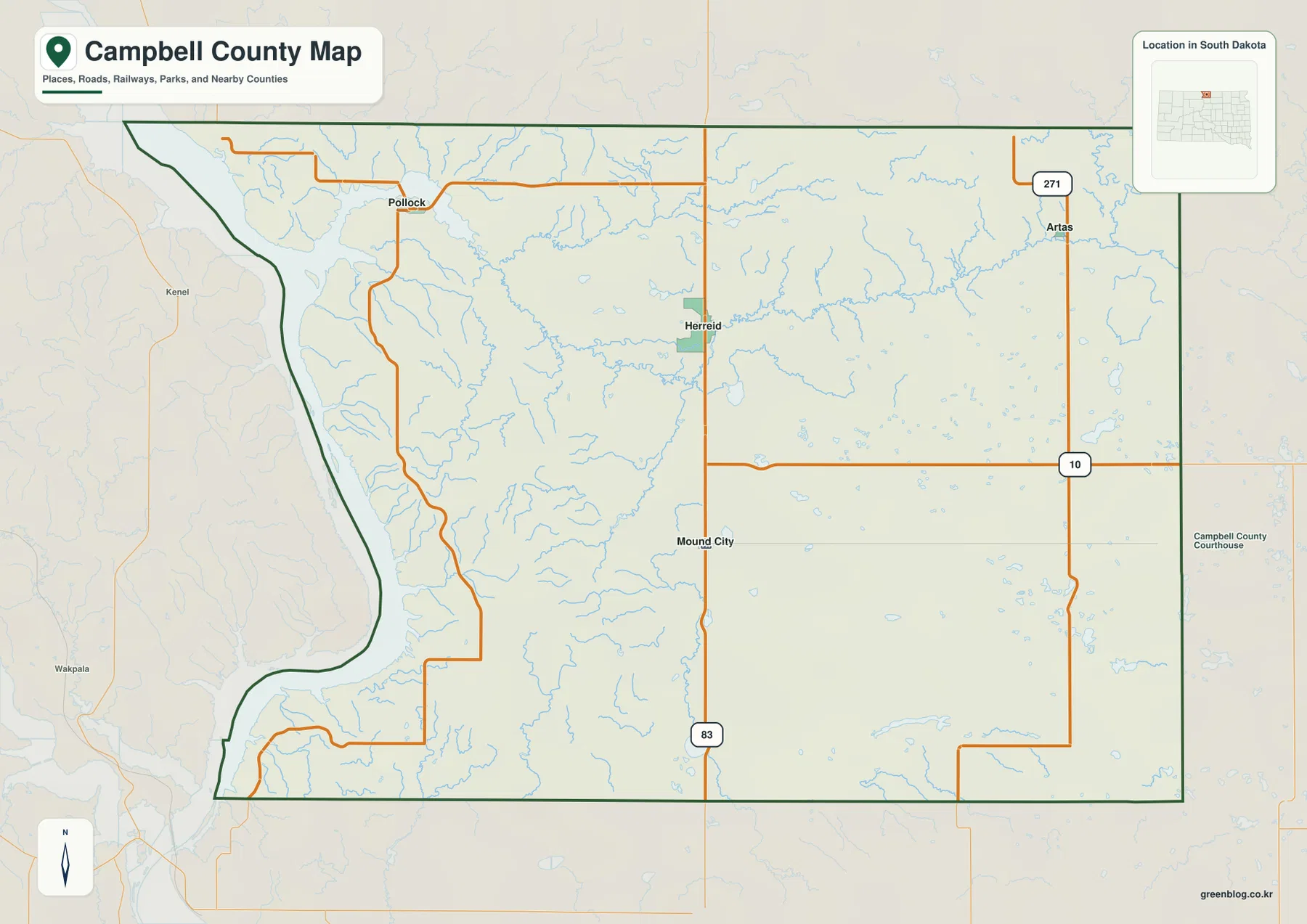
The western boundary is much more irregular than the eastern side because it follows the broad Missouri River and Lake Oahe corridor. South Dakota law describes Campbell County as reaching the North Dakota state line on the north and following the main channel of the Missouri River on the west. That legal description matches the map’s strongly curved western edge and helps explain why Pollock can lie far west of Herreid even though both are in the northern part of the county.
Straight-line spacing from Herreid separates the three surrounding communities
The city-connections view uses Herreid as the hub. Pollock is labeled about 11 miles away, Mound City about 8 miles, and Artas about 13 miles. These figures are direct, straight-line distances rather than driving mileage, so they are best used to compare relative spacing and direction. Actual road distance will depend on the route used.
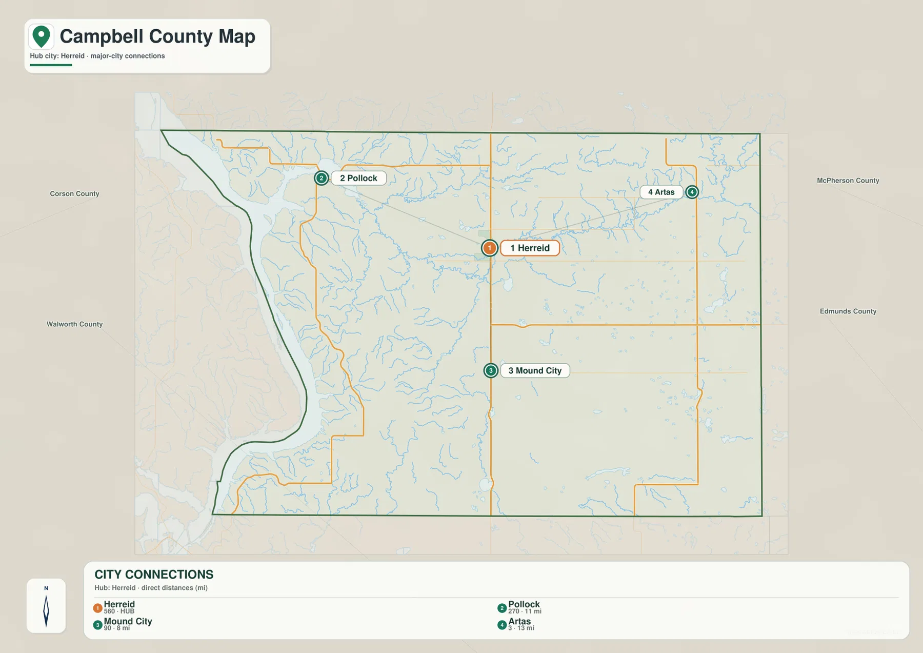
Mound City is the closest of the three connections shown and lies south of Herreid along the same general SD 83 corridor. Pollock is northwest toward the Lake Oahe side, while Artas is northeast and closer to SD 271. Reading the hub image together with the general map makes the direction changes much clearer than treating the three distances as a single ranked list.
The city index printed below the image also places a separate number beside each community. This article treats those as values printed in the supplied CITY CONNECTIONS graphic rather than as a statement of the latest population. For current population estimates or other time-sensitive statistics, the U.S. Census Bureau’s Campbell County QuickFacts page is the better source.
Lake Oahe, Lake Pocasse, and Spring Creek define the water view
The terrain-and-water map is dominated by Lake Oahe along the western boundary. Near the northwest, Lake Pocasse stands out as a large named water body, and the water network continues inland toward the long Spring Creek line across the north-central and eastern parts of the county. This creates a useful west-to-east sequence for map reading: first the reservoir edge, then Lake Pocasse, then the creek system extending through the county interior.
McClarem Lake is labeled near the central part of the main creek network, and Olson Creek approaches it from the south. Locke Creek appears farther west and points toward the Lake Oahe side. Near the southwest, Cane Creek and the Lake Oahe label sit close together. The map is most useful for identifying where named water features lie; it should not be read as a complete explanation of seasonal flow, water depth, or discharge.
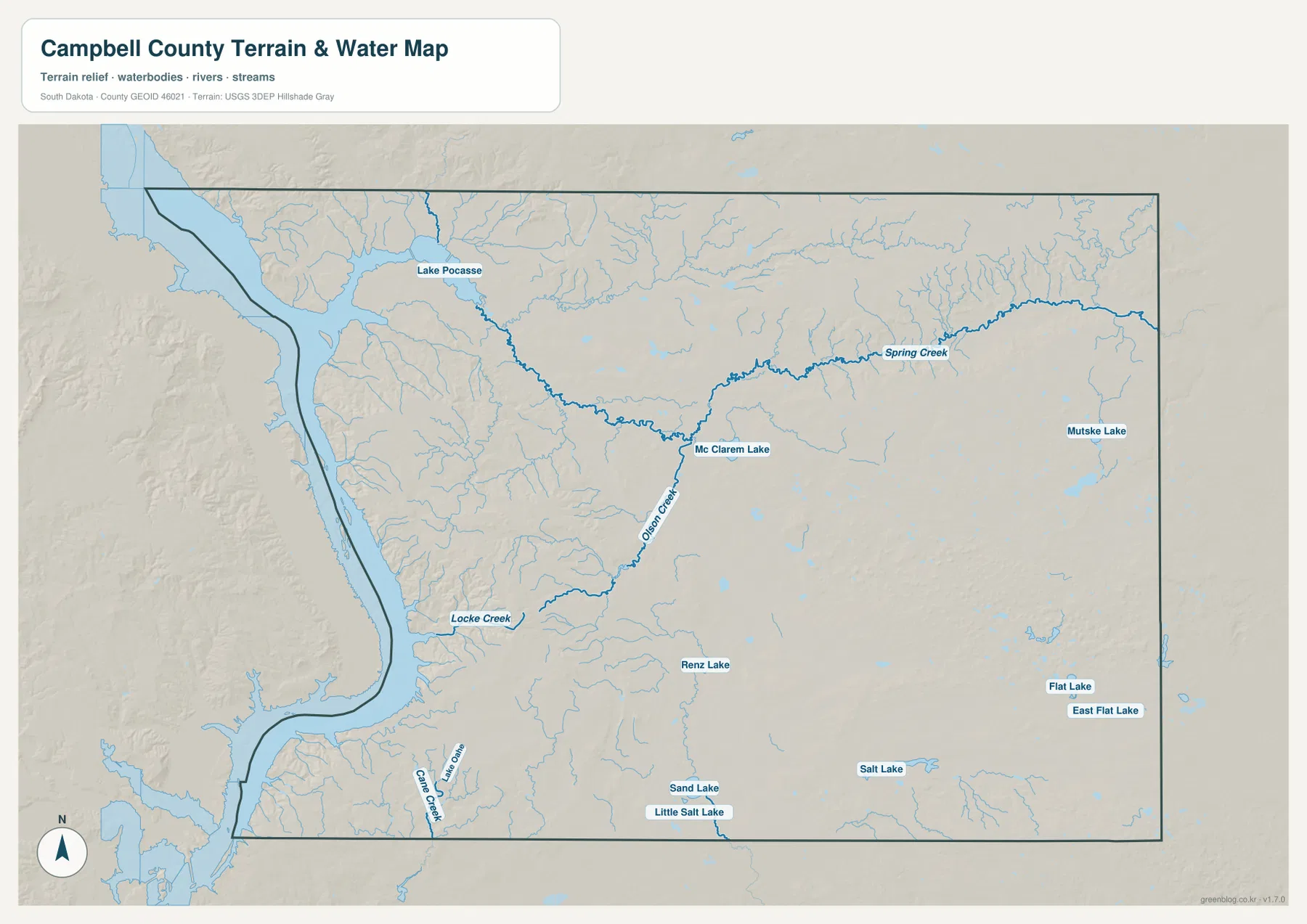
Several smaller lakes are labeled across the south and east. Renz Lake lies south of the central creek system, Sand Lake and Little Salt Lake appear close to the southern boundary, and Salt Lake sits farther east. Mutske Lake, Flat Lake, and East Flat Lake are labeled on the eastern side. The number of small named water bodies is one of the clearest features of the Campbell County water map and gives the eastern half much more detail than the road map alone.
This is a reference map for location and naming, not a flood map, current water-level report, fishing guide, or boating chart. Small streams and shallow lakes can change with season and weather. For present hydrography, flow, or water-management questions, use current USGS and local or state information.
Low reservoir margins give way to higher western hills and a high northeast corner
The elevation view reports an actual range of 487 to 647 meters with a mean of 547 meters. Dark green follows much of the Lake Oahe margin, showing that the reservoir edge is among the lower parts of the county. Just inland, however, several brown and tan uplands rise sharply, especially in the west-central and southwest interior. The close contact between low shoreline terrain and nearby higher ground is one of the most noticeable relief contrasts on the map.
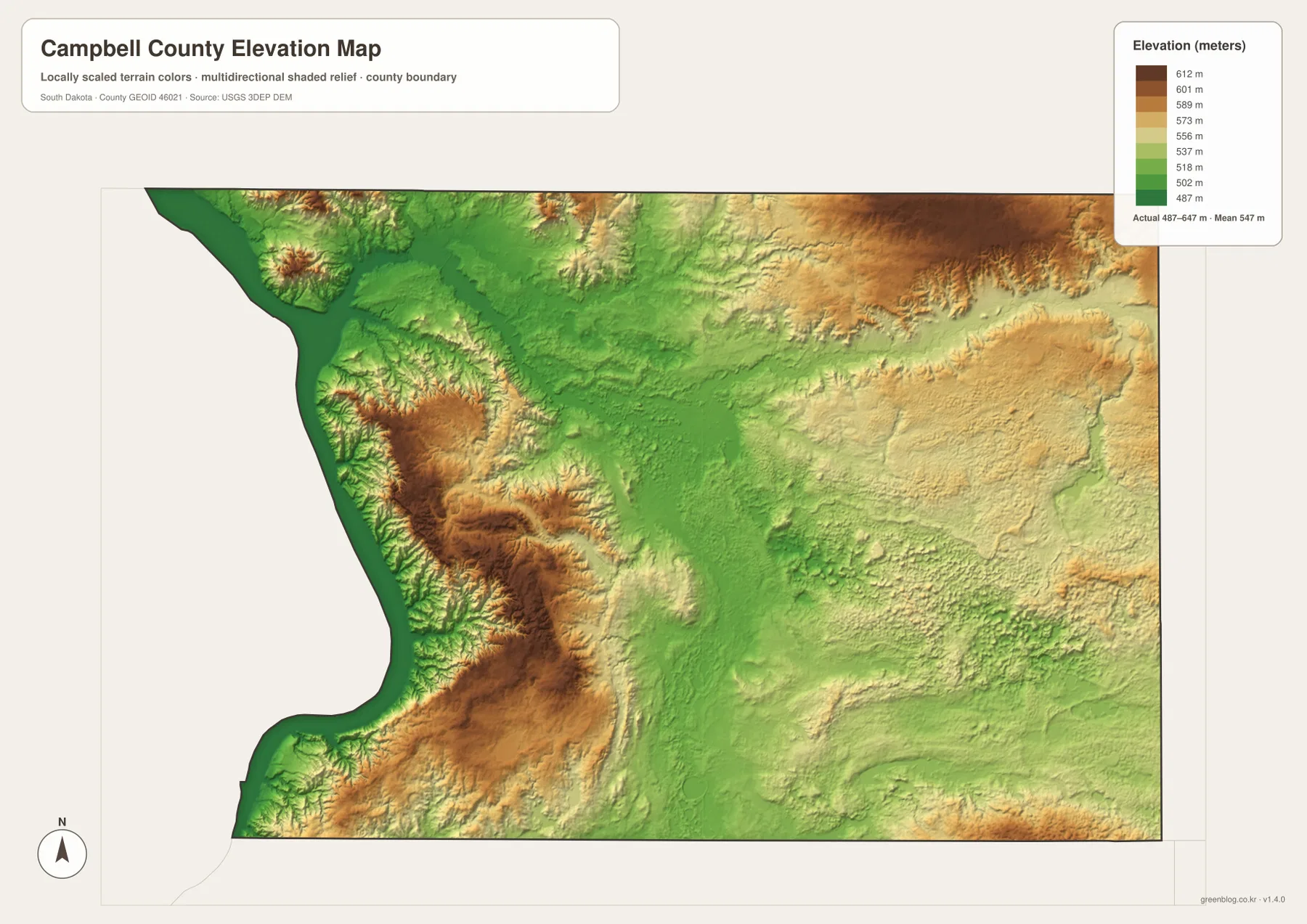
A broad green corridor runs through much of the central county from north toward south, creating a lower strip between higher areas. The northeast corner is very different: large areas turn tan and brown, making it one of the highest parts visible in the county. The southeast is more mixed, with green and lighter yellow-green terrain rather than the strong high colors seen in the northeast.
The elevation map is meant for county-scale comparison. It can show that the Lake Oahe shore is low relative to nearby uplands and that the northeast rises substantially, but it cannot provide a survey-grade elevation for a parcel, road point, or building. Detailed USGS 3DEP data or a professional survey should be used when a precise point elevation matters.
Following one town across the views makes the county easier to remember
Herreid works well as a starting example. The general map ties it to SD 83; the city-connections view shows Pollock, Mound City, and Artas spreading away from it in different directions; the water map places the long Spring Creek system across the broader northern interior; and the elevation map shows Herreid near the transition between the lower central corridor and higher ground to the northeast. Moving from one view to the next around the same reference point is more useful than memorizing isolated lists of map features.
Pollock provides a different set of cues. It sits in the northwest on the general map and is only about 11 straight-line miles from Herreid in the hub diagram. On the water map, the Lake Oahe side and Lake Pocasse make the northwest easy to recognize. Mound City is south of Herreid along the SD 83 corridor, while Artas is the eastern reference near SD 271. Each place therefore has a distinct combination of road, water, and direction clues.
Choose the view that matches the question you are asking. Use the general map for towns, roads, and the county outline; the hub image for straight-line spacing from Herreid; the water view for Lake Oahe, Spring Creek, and the smaller lakes; and the elevation image for the 487–647 meter relief pattern. The ZIP below contains the same map set as high-resolution JPG files for printing, classroom work, presentations, or close inspection. Legal boundary work, live road conditions, current water status, and survey-grade elevation require current authoritative data.
The download contains four JPG files matching the map views used in the article. Each original image is 3638 × 2572 pixels, providing much more detail for print and document use than the web previews.
Frequently Asked Questions
Are the 11, 8, and 13 mile labels driving distances from Herreid?
No. The city-connections image labels Pollock at about 11 miles, Mound City at about 8 miles, and Artas at about 13 miles from Herreid using direct distance. They should be read as straight-line spacing, not road mileage.
Why is Campbell County’s western boundary so curved?
The supplied map follows the Lake Oahe and Missouri River side of the county. South Dakota law describes the county’s western boundary as following the main channel of the Missouri River, which explains why the west edge is irregular while much of the east side is straighter.
Can the 487–647 meter range be used as the exact elevation of a property?
No. The range is useful for comparing high and low parts of the county, but the elevation surface is generalized at county scale. A precise site elevation should come from detailed USGS 3DEP data or professional survey information.
Map File Information
The Campbell County general, city-connections, terrain-and-water, and elevation views are packaged as high-resolution JPG files.
- Included Files: Use only the versions confirmed in the article and supplied images
- File Type: Use the confirmed download contents
- Intended Use: Printing, education, presentations, and map-based projects
Related Maps
Sources and References
The article is based first on the towns, roads, water features, and elevation values visible in the supplied Campbell County maps. These official sources provide additional boundary, county-statistics, hydrography, and elevation reference information.
- South Dakota Legislature – Campbell County boundaries
- U.S. Census Bureau QuickFacts – Campbell County
- USGS National Hydrography
- USGS 3D Elevation Program
Green Map creates custom-edited map images using open geographic data sources such as geoBoundaries, Natural Earth, OpenStreetMap, and government open data.
These maps are edited visual materials, not raw data files, and are provided for education, documents, presentations, and graphic reference.