Southeast Fairbanks Census Area covers a large part of eastern Interior Alaska, stretching from the Delta Junction area toward Tok, Eagle, and the Canadian border. Its geography is easier to understand through long highways, widely separated communities, major river valleys, and mountain country rather than through one compact urban center. This page brings those features together with a general census-area map, a city-location map, and a terrain-and-water map. The same subjects are also available below as high-resolution JPG files in a downloadable ZIP archive.
Delta Junction and Tok are the most useful road reference points on the maps. The Alaska Highway runs east from Delta Junction through the central part of the census area toward Tok and the Canadian border, while the Richardson Highway connects Delta Junction with Fairbanks and communities farther south. Near Tok, the road network branches again. The Taylor Highway leaves the Alaska Highway at Tetlin Junction and heads north through the Fortymile country toward Chicken and Eagle. Communities such as Big Delta, Deltana, Healy Lake, Dry Creek, Dot Lake, Tanacross, Tetlin, Northway, and Alcan Border appear along or near these long travel corridors.
Table of Contents
A census area organized around long roads and distant communities
The outline of Southeast Fairbanks Census Area is irregular and very large. Its western side meets the Fairbanks North Star Borough and Yukon-Koyukuk Census Area, while Copper River Census Area lies to the south and southwest. The eastern side reaches the international boundary with Canada. On a regional map, this creates several distinct parts: Delta Junction in the west, Tok and the upper Tanana region in the center, Eagle and Chicken in the northeast, and Tetlin, Northway, and Alcan Border farther southeast.
The road map gives those broad sections a practical structure. Delta Junction sits where the Alaska Highway and Richardson Highway meet. Traveling east, the Alaska Highway passes through or near Deltana, Healy Lake, Dry Creek, Dot Lake, Tanacross, and Tok. From Tok, the main route continues toward Tetlin, Northway, and the Canadian border, while other roads lead south and northeast. This is a useful way to orient yourself because many places are separated by dozens or hundreds of miles rather than by short local streets.
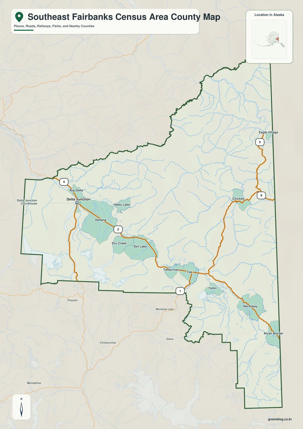
Several Alaska route numbers are visible on the map. Alaska DOT identifies the Alaska Highway as Route 2 between the Canadian border, Tok, Delta Junction, and Fairbanks. The Richardson Highway is Route 4 through the Delta Junction area, and the Taylor Highway is Route 5 from Tetlin Junction to Eagle. Route 1 appears on the Tok Cutoff connection. These highways are important not only because they link communities but also because they explain why settlement labels form long chains across an otherwise sparsely roaded landscape.
A map line does not guarantee simple travel conditions. The eastern Interior has long distances between services, winter weather, road construction, and seasonal maintenance concerns. Alaska DOT notes that the Taylor Highway includes gravel sections and that conditions can vary during its travel season. For an actual drive, current Alaska 511 information should be checked separately. The map here is best used for orientation, regional comparison, and understanding how roads connect the named places.
Delta Junction and Eagle are the two incorporated cities in the city index
The city-location map simplifies the census area by highlighting two incorporated cities: Delta Junction and Eagle. Delta Junction is ranked first in the map index, while Eagle is ranked second. They occupy very different parts of the region. Delta Junction lies near the western road junctions and the upper Tanana lowlands, whereas Eagle sits far to the northeast near the Yukon River and the northern end of the Taylor Highway.
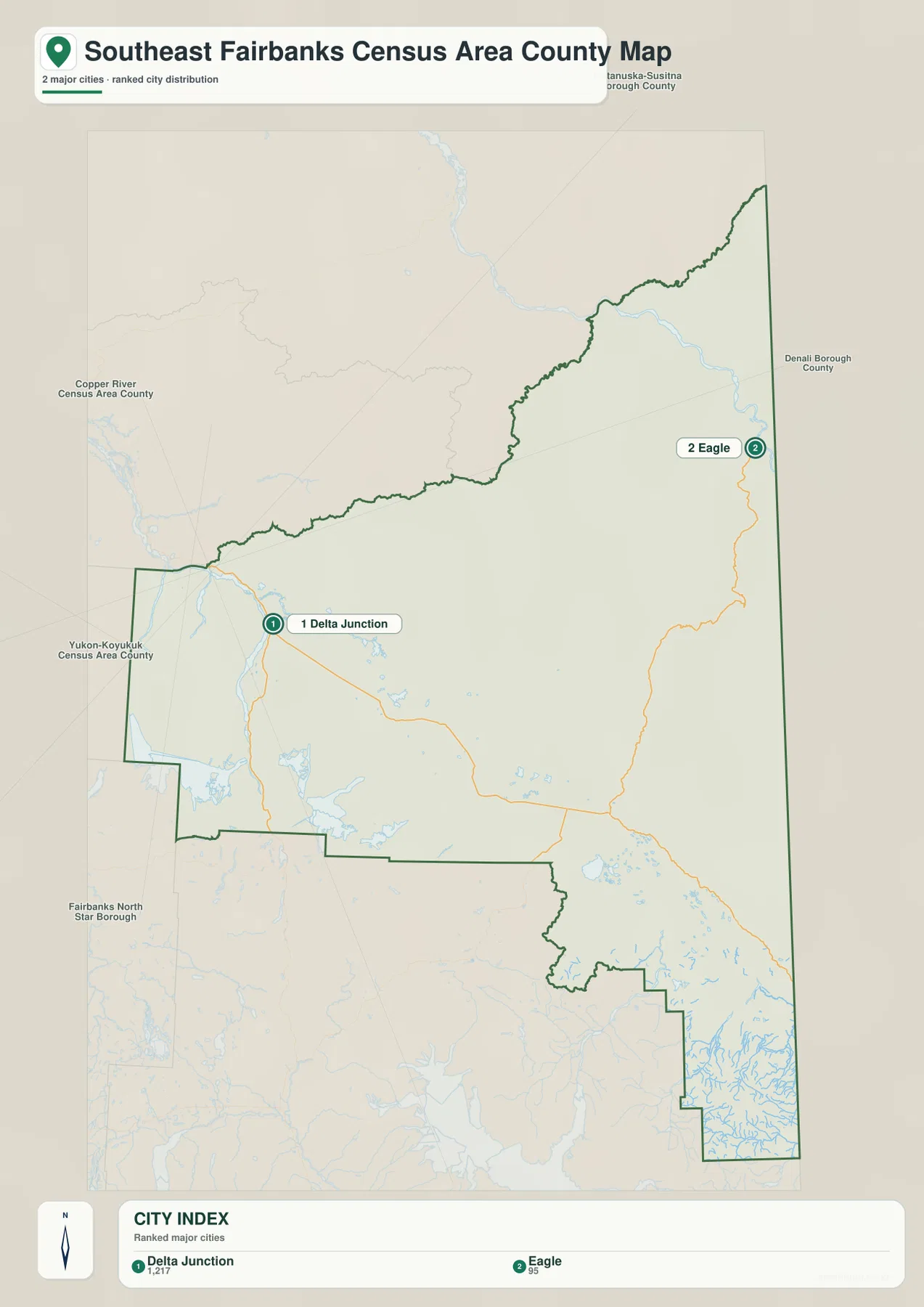
Other familiar labels do not receive numbered city markers because the map is specifically a ranked incorporated-city layer. Tok, for example, is one of the most important road and service points in the census area, but it is not shown as an incorporated city in this index. Chicken, Northway, Tetlin, Big Delta, Deltana, and Tanacross are also better understood on the general map, where community names can be viewed together with highways and the census-area boundary.
The contrast between the two numbered cities is useful for explaining the size of the region. Delta Junction is close to the western edge and to the road system leading toward Fairbanks. Eagle is reached from the Taylor Highway corridor and is closely associated with the Yukon River valley. Their separation shows why a simple city-to-city distance is not enough to describe Southeast Fairbanks. The surrounding roads, rivers, and mountain terrain are part of the location story.
Tanana and Yukon river systems divide the map into different landscapes
The terrain-and-water map shifts attention from highways to the river network. In the western portion, the Delta River and Little Delta River approach the Delta Junction area. Farther east, the Robertson River and Tanana River form prominent water corridors across the central and southern part of the census area. Near Tok, the Tok River joins the broader upper Tanana drainage. In the southeast, the Tetlin River and Chisana River appear among a dense pattern of lakes and smaller channels.
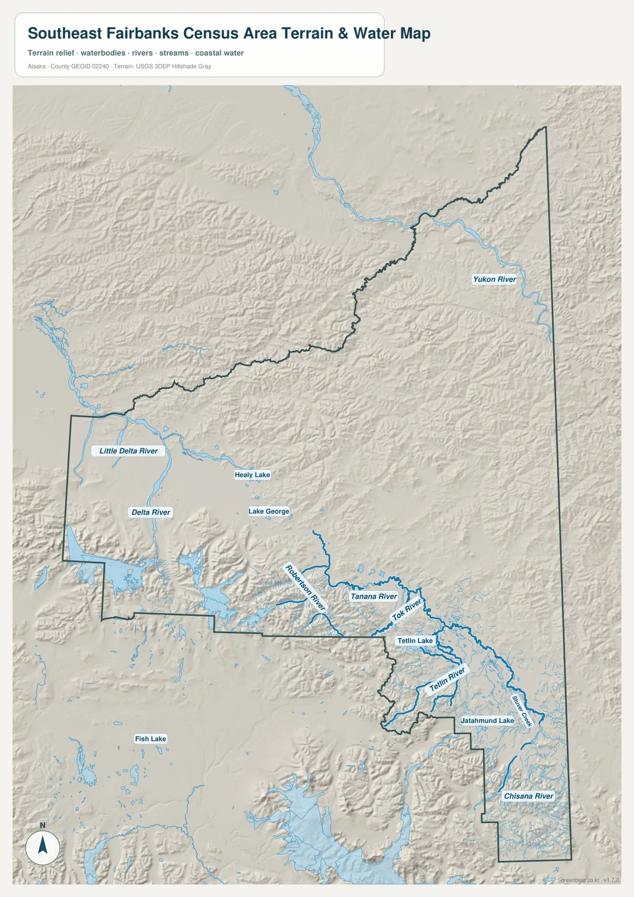
The northeastern section belongs to a different major river setting. The Yukon River is labeled near Eagle, crossing the upper part of the map and continuing beyond the census-area boundary. This separates Eagle geographically from communities along the upper Tanana and Alaska Highway corridors. Looking at the water map next to the road map makes that difference much clearer: the main highways generally follow valleys and lower terrain, while the broad mountain areas between them have far fewer road connections.
Lakes provide additional reference points. Healy Lake and Lake George are labeled in the west-central part of the census area, while Tetlin Lake and Jatahmund Lake appear in the southeast. Numerous smaller lakes and wetlands are visible around the upper Tanana lowlands and the Tetlin-Northway area. The shaded terrain also shows broad mountain belts north of the central highway corridor and along parts of the southern boundary, contrasting with lower river valleys and basin floors.
This map is a geographic reference rather than a flood-hazard, navigation, or engineering product. It does not provide river depth, discharge, flood probability, water quality, surveyed elevations, or safe boating information. For technical work, USGS hydrography and other current purpose-specific datasets should be used. The shaded relief is included to make major landforms easier to see, not to replace detailed elevation measurements.
Choosing the best map for orientation, cities, or rivers
Use the general map when your main question is where places and highways sit inside the census area. It is the strongest choice for tracing the Alaska Highway from Delta Junction toward Tok and the Canadian border, identifying the Richardson Highway connection, or following the Taylor Highway north toward Chicken and Eagle. It also includes a wider selection of community labels than the city map.
The city map is more effective when you want a quick comparison of Delta Junction and Eagle as incorporated cities. Their numbered markers make it clear that they are widely separated and belong to different road and river settings. If a project also needs Tok, Tetlin, Northway, or Chicken, combine this view with the general map rather than treating the city index as a complete settlement map.
Choose the terrain-and-water map when the Tanana River, Yukon River, Delta River, Tok River, Tetlin River, lakes, or mountain relief matter more than administrative labels. The embedded WebP images are convenient for reading the article, but the original JPG files are better for printing and close inspection. The download archive contains the general map, city-location map, and terrain-and-water map at 2572 by 3638 pixels each.
Frequently Asked Questions
Why is Tok not numbered on the city map?
The city map is a ranked layer for incorporated cities, and it shows Delta Junction and Eagle. Tok is an important community and highway junction, but it is not represented as an incorporated city in this particular index. Use the general map when you want to see Tok together with surrounding roads and other communities.
Can I use the map to plan a drive from Delta Junction to Eagle?
The map can show the broad route relationship, but it should not be used as a current road-condition guide. Eagle is reached through the Taylor Highway corridor, which leaves the Alaska Highway at Tetlin Junction and passes through the Chicken area. Alaska DOT notes that parts of the Taylor Highway are gravel and conditions vary, so current Alaska 511 and DOT information should be checked before travel.
Is the terrain-and-water map suitable for flood or navigation decisions?
No. It is a general reference showing the relative locations of rivers, lakes, and terrain. It does not contain flood probabilities, water depths, discharge measurements, navigation channels, or engineering-grade elevations. Use current USGS and other official purpose-specific products for safety, hydrology, navigation, or design work.
Map File Information
The archive includes the Southeast Fairbanks Census Area general map, city-location map, and terrain-and-water map as high-resolution JPG files.
- Included Files: 3 JPG maps
- Printable Size: 2572×3638 pixels each
Related Maps
Sources and references
- Alaska Department of Labor and Workforce Development – Southeast Fairbanks Census Area Map: official Alaska reference for the census-area boundary and community locations
- Alaska DOT&PF – Taylor Highway: route information for the Tetlin Junction–Chicken–Eagle corridor
- Alaska DOT&PF – Richardson Highway: official highway information for the Delta Junction corridor
- U.S. Census Bureau TIGER/Line Shapefiles: authoritative boundary and geographic reference data
- USGS National Hydrography: official hydrography reference for rivers, lakes, and related water features
Green Map creates custom-edited map images using open geographic data sources such as geoBoundaries, Natural Earth, OpenStreetMap, and government open data.
These maps are edited visual materials, not raw data files, and are provided for education, documents, presentations, and graphic reference.