The Bureau County Illinois Land Cover Map set is overwhelmingly agricultural, but the county is not visually uniform. Agriculture accounts for 82.61% of the 2025 summary, developed land for 7.38%, forest for 7.19%, wetlands for 2.00%, and water for 0.57%. Princeton forms the strongest developed center near the middle, while the Illinois River side of the county carries a more complicated mix of water, wetlands, woodland, and smaller settlement clusters.
This page includes four views: current land cover, forest and farmland, impervious surface and developed land, and a 1985–2025 class-difference comparison. The WebP images can be examined directly in the article, and the four original 2480 × 1754-pixel JPG maps are available together in one ZIP download for county profiles, agricultural lessons, presentations, and environmental comparison.
Table of Contents
Princeton stands out because most of Bureau County has very little hard surface
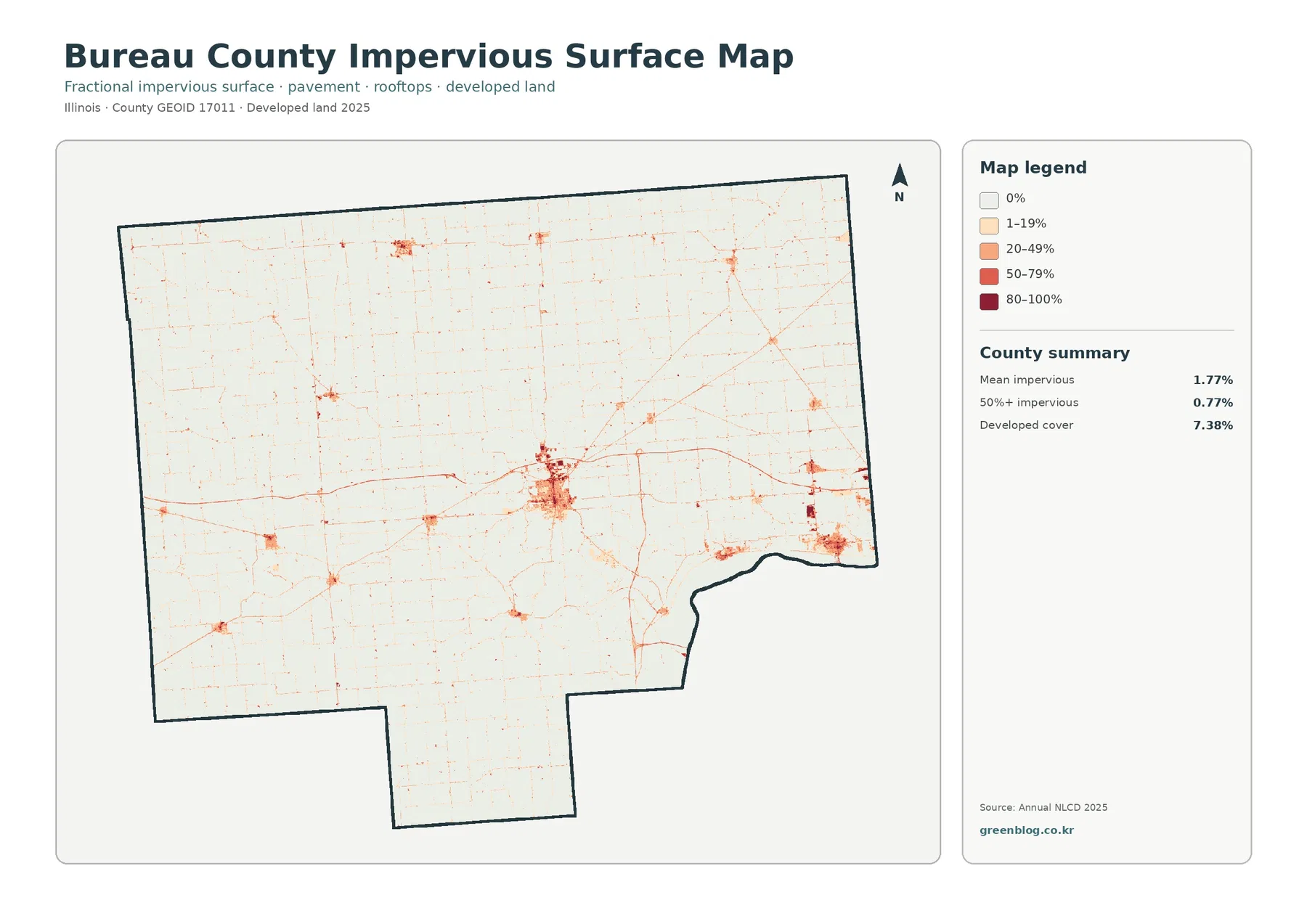
Bureau County has a mean impervious value of 1.77%, and 0.77% of the county is mapped at 50% impervious or greater. Those figures are well below the 7.38% developed land-cover share because developed classes can include lawns, trees, bare soil, and other permeable ground. The impervious map narrows the view to harder surfaces such as roofs and pavement.
The darkest concentration sits near the center of the county. Bureau County’s official tourism page identifies Princeton as both the county seat and the county’s largest city, centrally located on Interstate 80 where Routes 6, 26, 29, and 34 meet. That description fits the large central cluster and the thin developed traces that radiate around it, although the raster map does not label individual routes.
The 2025 overview shows why an 82.61% farm county still needs a river-and-wetland explanation
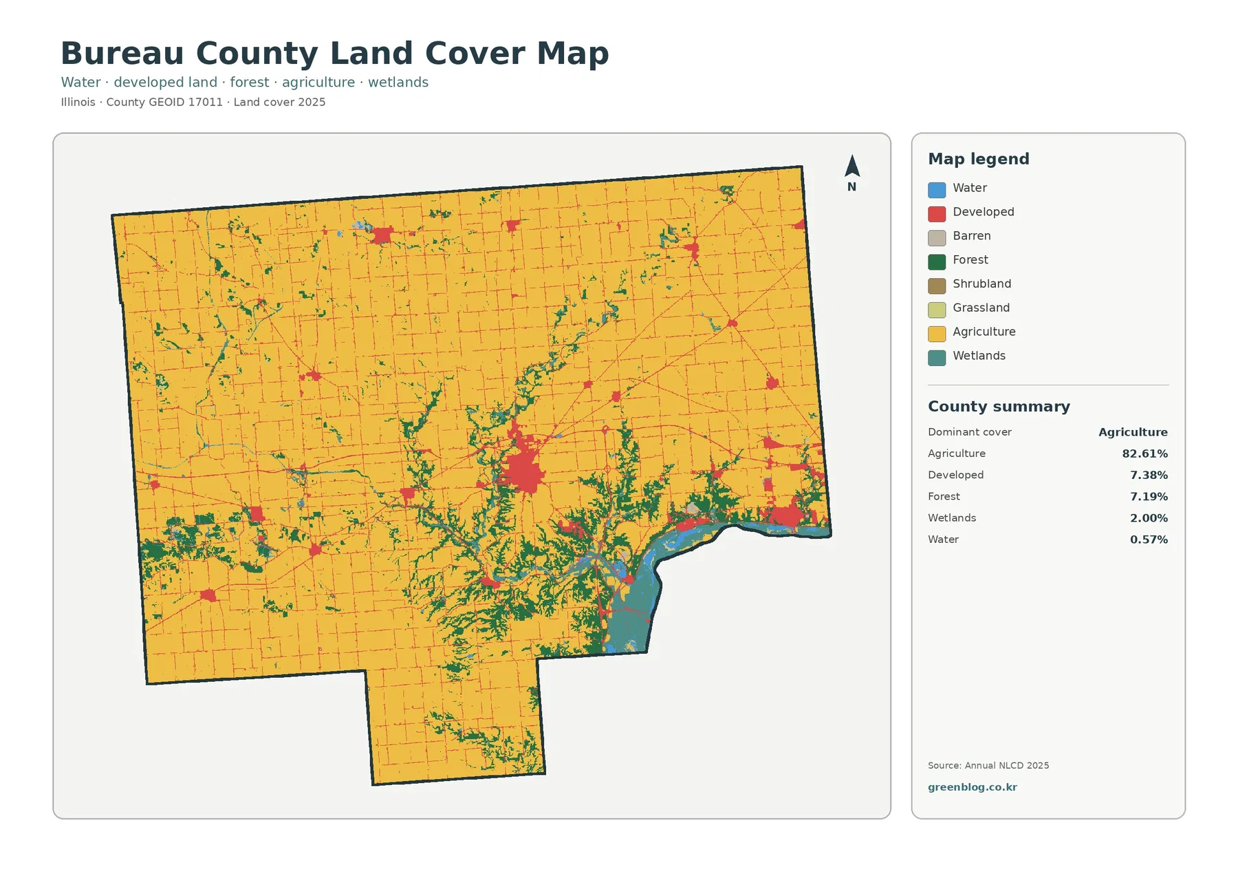
Yellow agricultural cover fills most of the north, west, center, and south. Large field blocks continue between the county’s towns and around the Princeton area, so the 82.61% agricultural share is visible immediately. Development, woodland, and wet ground interrupt the farm grid in selected places rather than dividing the county into separate agricultural and nonagricultural halves.
Forest covers 7.19%. Green patches are scattered in the northwest and southwest, but the densest wooded pattern occurs from the south-central interior toward the Illinois River side. Several narrow green corridors branch through the farm matrix. Their shape suggests drainage or valley woodland in places, but the land-cover image alone does not identify a named creek or a specific physical cause.
Wetlands cover 2.00% and water 0.57%. The southeast contains the strongest combination of teal wetland and blue water, with additional narrow wet features extending into the county. Bureau County’s parks page describes the Donnelley/DePue State Fish and Wildlife Area as bordering the Illinois River and the Bureau Junction Hormel Ponds as being surrounded by marshland, bottomland woods, and the Hennepin Canal. Those local descriptions match the more complex river-edge pattern.
Removing urban color reveals how little nonfarm open vegetation is present
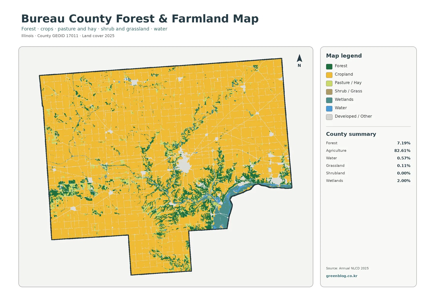
Once developed and miscellaneous surfaces are faded, cropland dominates even more clearly. Princeton becomes a pale opening surrounded by fields, and the smaller towns leave similar gaps within the agricultural matrix. Forest and wetlands are easier to trace because they no longer compete with the red developed class.
Grassland is only 0.11% and shrubland rounds to 0.00% in the supplied county summary. Open grass and shrub cover are therefore not defining features of Bureau County. The useful vegetation contrast is between extensive cropland and the smaller wooded and wet corridors that cut through it.
The strongest natural-cover concentration remains in the south and southeast. Woodland, wetlands, and open water meet near the Illinois River side, while field blocks occupy much of the flatter-looking interior. A 30-meter raster cell can contain a field edge, trees, ditch, road, and small building while still receiving one predominant label, so the colored edges are not surveyed farm parcels.
Hennepin Canal and Illinois River references help interpret the southeast without turning the map into a hydrography chart
Illinois DNR describes the Hennepin Canal State Trail as beginning at Bureau Junction near the Illinois River and running west toward the Rock River, with the parkway broadly paralleling I-80 through Bureau and Henry counties. Bureau County’s own canal page also places the visitor center near Sheffield and I-80. These references help explain why water, wetland, and wooded cover occur in recognizable corridors instead of random isolated spots.
The general land-cover image should still be read as a surface-class map, not a detailed waterways map. A blue or teal cell can support a county-scale description of water or wet ground, but it does not provide the exact canal width, riverbank, levee line, or wetland jurisdiction. Site-level water questions require current hydrography, parcel, and regulatory data.
Only 4.83% of cells differ at the 1985 and 2025 endpoints
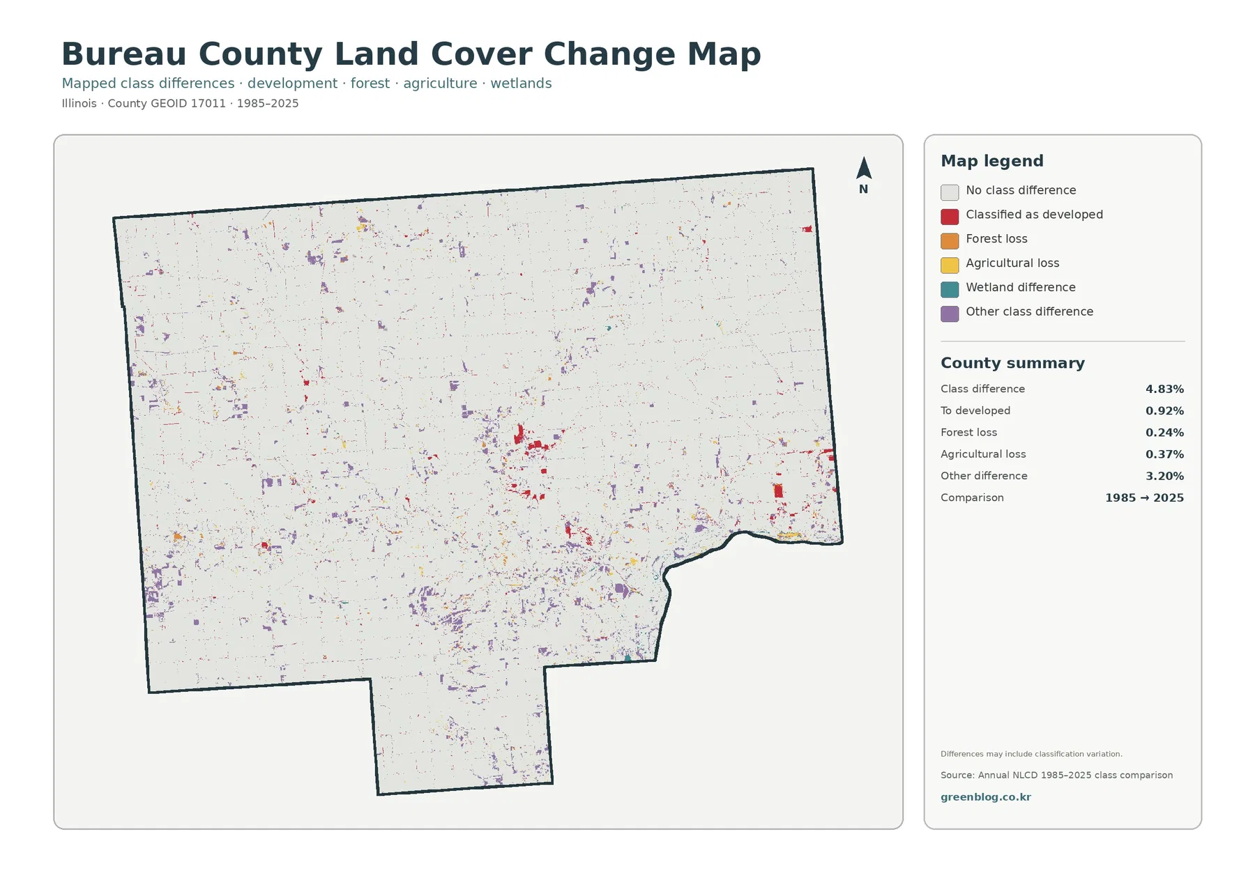
The endpoint comparison reports 4.83% total class difference, lower than many county-scale comparisons where change colors occupy broad areas. Listed components are 0.92% classified as developed, 0.24% forest loss, 0.37% agricultural loss, and 3.20% other difference. Wetland difference appears in the legend without a printed percentage, so it should not be estimated from the image or treated as an official residual.
Loss in this legend means a different classification at the two endpoints. It does not establish construction, abandonment, logging, flooding, or another cause. Seasonal conditions, mixed 30-meter pixels, and classification variation can contribute. Intermediate imagery and local records are needed before assigning a date or explanation to a specific change cell.
A practical map sequence starts broad and ends with the endpoint comparison
Use the impervious map when the subject is built-surface intensity. The 1.77% county mean can be compared with the much darker Princeton cluster and smaller southeastern centers. Place the change map last so readers do not confuse present-day developed land with cells that merely changed to a developed class between the two endpoints.
Files included in the four-map JPG download
The ZIP contains one JPG each for 2025 land cover, forest and farmland, impervious surface and developed land, and 1985–2025 land-cover change. The shared county boundary makes it easy to compare Bureau County’s agricultural grid, Princeton hard surfaces, Illinois River and Hennepin Canal natural cover, and endpoint class differences.
Frequently Asked Questions
How dominant is agriculture in Bureau County?
Agriculture covers 82.61% of the supplied 2025 summary. It forms the broad background across nearly the entire county, while Princeton, smaller towns, wooded drainages, wetlands, and the Illinois River edge interrupt that farm matrix in selected places.
Why is the southeast more varied than the rest of the county?
The supplied maps place the strongest combination of water, wetlands, forest, and developed land in the southeast. Bureau County’s official parks information connects DePue and Bureau Junction with the Illinois River, marshes, bottomland woods, and the Hennepin Canal. Those references explain the local context without making the land-cover cells legal water or wetland boundaries.
Does the 4.83% class-difference value show exactly how much land physically changed after 1985?
No. It is the share of cells receiving different classifications at the 1985 and 2025 endpoints. Real land-surface change can contribute, but mixed pixels, seasonal conditions, and classification variation can also matter. Intermediate imagery and local records are needed to establish timing and cause.
Sources and Reference Data
- MRLC Annual NLCD Data – official access point for annual land-cover and comparison products
- USGS Annual NLCD Land Cover Classification – official guidance for the 30-meter land-cover classes
- U.S. Census Bureau TIGER/Line Shapefiles – official county-boundary reference for Bureau County
- Bureau County Tourism – official county context for Princeton, I-80, major routes, and local communities
- Bureau County Parks & Recreation – official local context for the Illinois River, DePue, Bureau Junction, marshland, and the Hennepin Canal
- Illinois DNR – Hennepin Canal State Trail – official location and park information for the canal in Bureau County
Map File Information
The ZIP contains four original JPG maps for comparing Bureau County's agricultural landscape, Princeton development and hard surfaces, Illinois River and Hennepin Canal natural cover, and 1985–2025 class differences.
- Included Files: Use only the versions confirmed in the article and supplied images
- File Type: Use the confirmed download contents
- Intended Use: Printing, education, presentations, and map-based projects
Related Maps
- Adams County Illinois Land Cover Map
- Alexander County Illinois Land Cover Map
- Bond County Illinois Land Cover Map
Green Map creates custom-edited map images using open geographic data sources such as geoBoundaries, Natural Earth, OpenStreetMap, and government open data.
These maps are edited visual materials, not raw data files, and are provided for education, documents, presentations, and graphic reference.