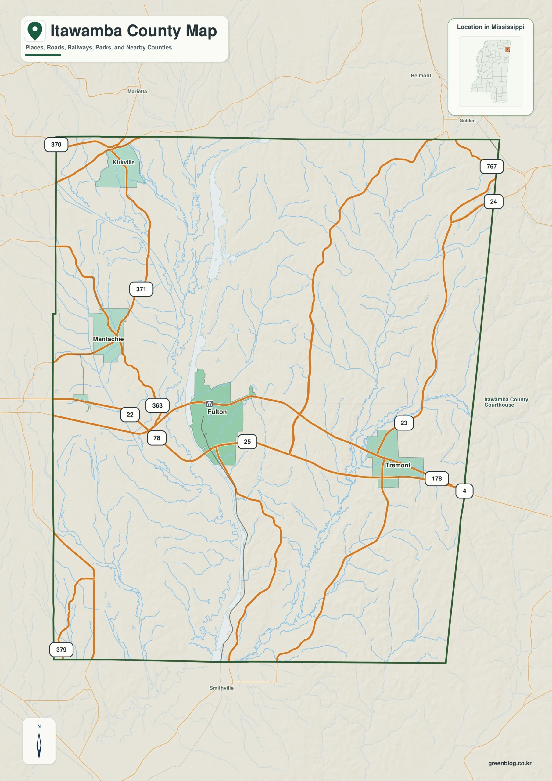
Fulton and the Tennessee-Tombigbee Waterway provide the central pair on the Itawamba County Mississippi map. Mantachie, Tremont, and Plantersville then establish western, northeastern, and southwestern directions, while I-22 gives the county a fast regional connection.
Itawamba County Mississippi map download
The WebP preview is optimized for the page, while the button preserves the original high-resolution JPG for printing and reuse.
- File: County reference map
- Format: JPG
- Print layout: A3
Quick Facts
- State and identifier: Mississippi, Itawamba County; FIPS 28057
- County seat: Fulton
- Selected map labels: Fulton, Mantachie, Tremont, Plantersville
- 2020 census population: 23,863
- July 2025 population estimate: 24,152
- 2025 Gazetteer area: 532.795 sq mi land and 7.655 sq mi water
- 2020 land-area density: 44.8 residents per sq mi
- Primary route references: I-22/US 78, MS 25, MS 23, and MS 178
- Landscape references: Tennessee-Tombigbee Waterway, Tombigbee River, Bull Mountain hills, and the Alabama line
The decennial count and July 2025 estimate use different reference dates. Land and water measurements come from the 2025 Gazetteer. The density of 44.8 residents per square mile divides the 2020 population by 2025 land area and does not imply an even distribution among cities, farms, forest, or wetland.
Reading the Itawamba County Mississippi map
Fulton lies where MS 25 meets the I-22/US 78 corridor. Mantachie points toward Lee County, Tremont toward the northeastern Alabama line, and Plantersville toward Monroe County. Waterway locks, boat facilities, and small rural roads are beyond the selected county-scale labels.
Boundary, Water, and Terrain
The Tennessee-Tombigbee Waterway follows the Tombigbee system through the middle of the county. Hills become more pronounced toward the northeast and Bull Mountain country, whereas the terrain eases westward toward Lee County. Franklin and Marion counties in Alabama meet Itawamba along its eastern edge.
The scale of Tennessee-Tombigbee Waterway and Tombigbee River can be misjudged beside 532.795 square miles of land and 7.655 square miles of mapped water. Use Fulton and Mantachie as fixed points, then compare them with the boundary toward Prentiss. Together, Tennessee-Tombigbee Waterway and Tombigbee River and the Prentiss side reveal more than the apparent size of any one symbol. The relationship between Mantachie and Prentiss is complete enough for orientation, not a full road inventory.
Settlement and Regional Context
Itawamba Community College reinforces Fulton's role as more than a courthouse town. I-22 connects the area with Tupelo and Birmingham, while the waterway supplies a separate freight and water-management corridor. A slight gain from the 2020 census to the 2025 estimate contrasts with declines in several western Mississippi counties.
Practical Map Uses
- Locate the I-22 and MS 25 junction at Fulton
- Relate Tremont to Alabama and the northeastern hills
- Compare Mantachie and Plantersville west of the waterway
Frequently Asked Questions
Does the Tenn-Tom Waterway follow the same route as I-22?
No. The waterway runs mainly north-south through the county, while I-22 crosses east-west near Fulton. Their intersection gives the county two very different transport axes.
What geographic context does Tennessee-Tombigbee Waterway provide from Fulton toward Prentiss?
From Fulton, Tennessee-Tombigbee Waterway supplies a terrain or water cue for tracking the county toward Prentiss; precise access still belongs to a specialized map.
Sources
- U.S. Census Bureau QuickFacts
- U.S. Census Bureau 2025 Gazetteer Files
- Mississippi Department of Transportation official highway map
- Regional landscape or institution reference
Related County Maps
Green Map creates custom-edited map images using open geographic data sources such as geoBoundaries, Natural Earth, OpenStreetMap, and government open data.
These maps are edited visual materials, not raw data files, and are provided for education, documents, presentations, and graphic reference.