Alleghany County sits in the mountain region of northwestern North Carolina, directly along the Virginia state line. Sparta is the county seat and the clearest settlement reference on the maps in this package. From that central point, the county map shows numbered highways, the county boundary, and a dense network of streams, while the terrain and water map makes the river valleys and surrounding relief much easier to see. The three high-resolution A3 JPG maps shown on this page are also available together as a downloadable ZIP.
This is a compact mountain county rather than a broad lowland area built around several large cities. The supplied city map identifies Sparta as the major city reference, and the general county map places it near the middle of the county. Around it, roads spread toward the Virginia line and toward neighboring Ashe, Wilkes, and Surry counties. New River and Little River add a second set of reference points because the valleys explain why the physical layout does not look like a simple grid.
Each map is useful for a different reason. The county map is the best starting point for roads, boundaries, Sparta, and the main stream network. The city map removes much of the visual detail so the location of Sparta is immediate. The terrain and water map shifts attention to New River, Little River, named creeks, small lakes, and the mountain surface. Reading them together gives a clearer picture of Alleghany County without asking one map to carry every kind of information.
Table of Contents
A mountain county immediately south of Virginia
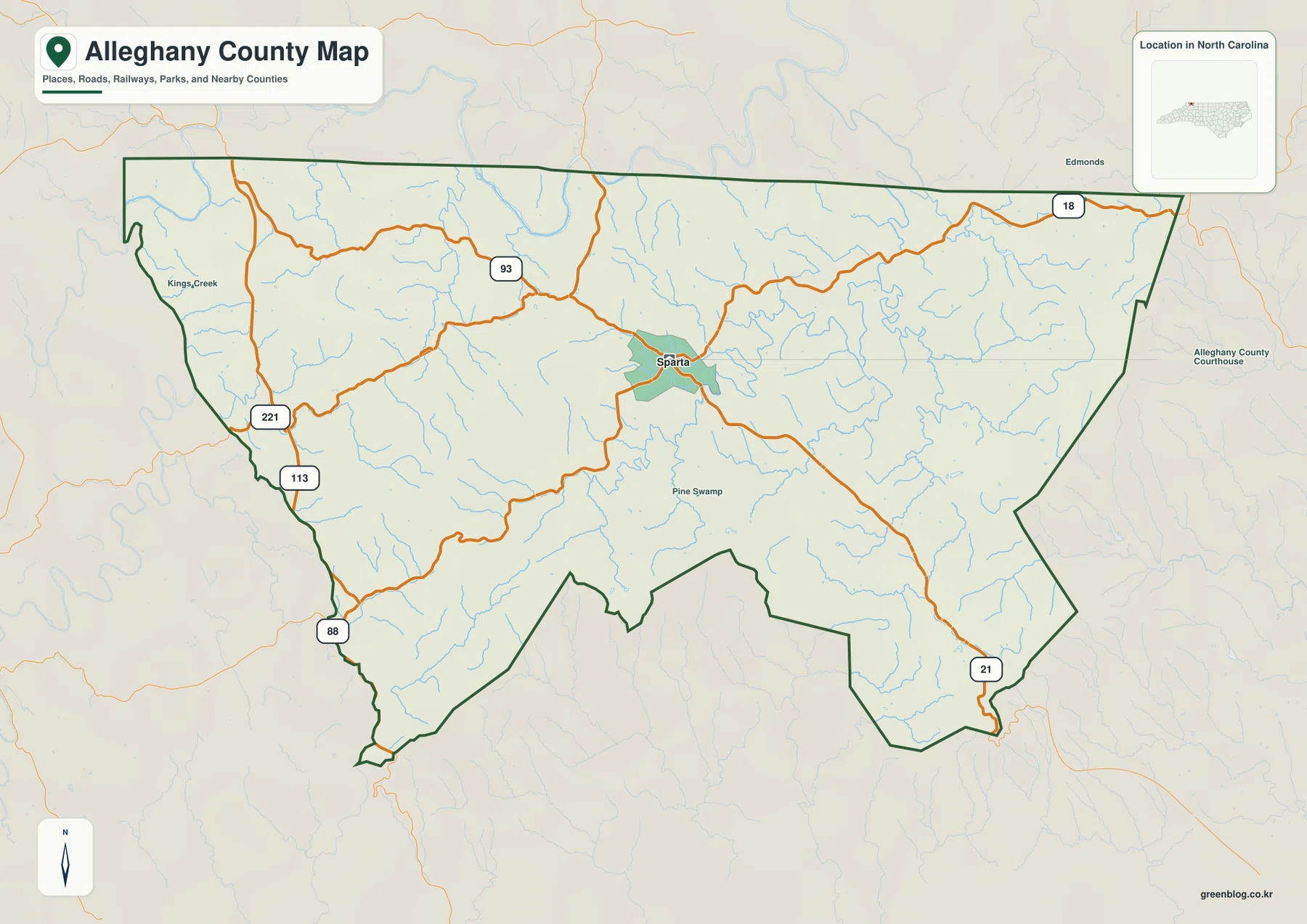
The northern edge of Alleghany County follows the state line with Virginia. On the map it is noticeably straighter than the southern boundary, which bends through a series of irregular turns. That contrast makes the county outline easy to recognize even before individual roads or streams are considered. The map package describes Alleghany as a Virginia-border mountain county shaped by river valleys and the Continental Divide, and the shaded terrain image supports that description by showing closely spaced ridges and hollows across the county.
The terrain is important because it changes how the roads and waterways should be read. Streams gather in narrow valleys rather than crossing the county in straight lines, and the larger channels curve through lower ground between the ridges. The general map keeps the background restrained so roads remain easy to follow, while the terrain version makes the same county look much more rugged. That difference is useful when a reader wants to move from basic orientation to an explanation of the natural setting.
Sparta as the road and orientation reference
Sparta is close to the middle of the mapped county and acts as the most convenient starting point for following the road system. Several routes meet or pass through the area around town, then spread toward different sides of Alleghany County. The supplied county map labels U.S. Route 221 along with North Carolina routes 18, 21, 88, 93, and 113. Those route numbers are enough to understand the main directions of travel without turning the page into a street-level navigation map.
On the western side, U.S. 221 and the NC 113 and NC 88 corridors appear close to the Ashe County side of the boundary. NC 93 connects through the central part of the county toward Sparta, while NC 18 is visible near the northeastern edge and NC 21 leaves the county in the southeast. The exact purpose of the map is orientation rather than turn-by-turn driving, so the useful question is not the name of every small road. It is how the numbered routes relate to Sparta, the county boundary, and the neighboring counties.
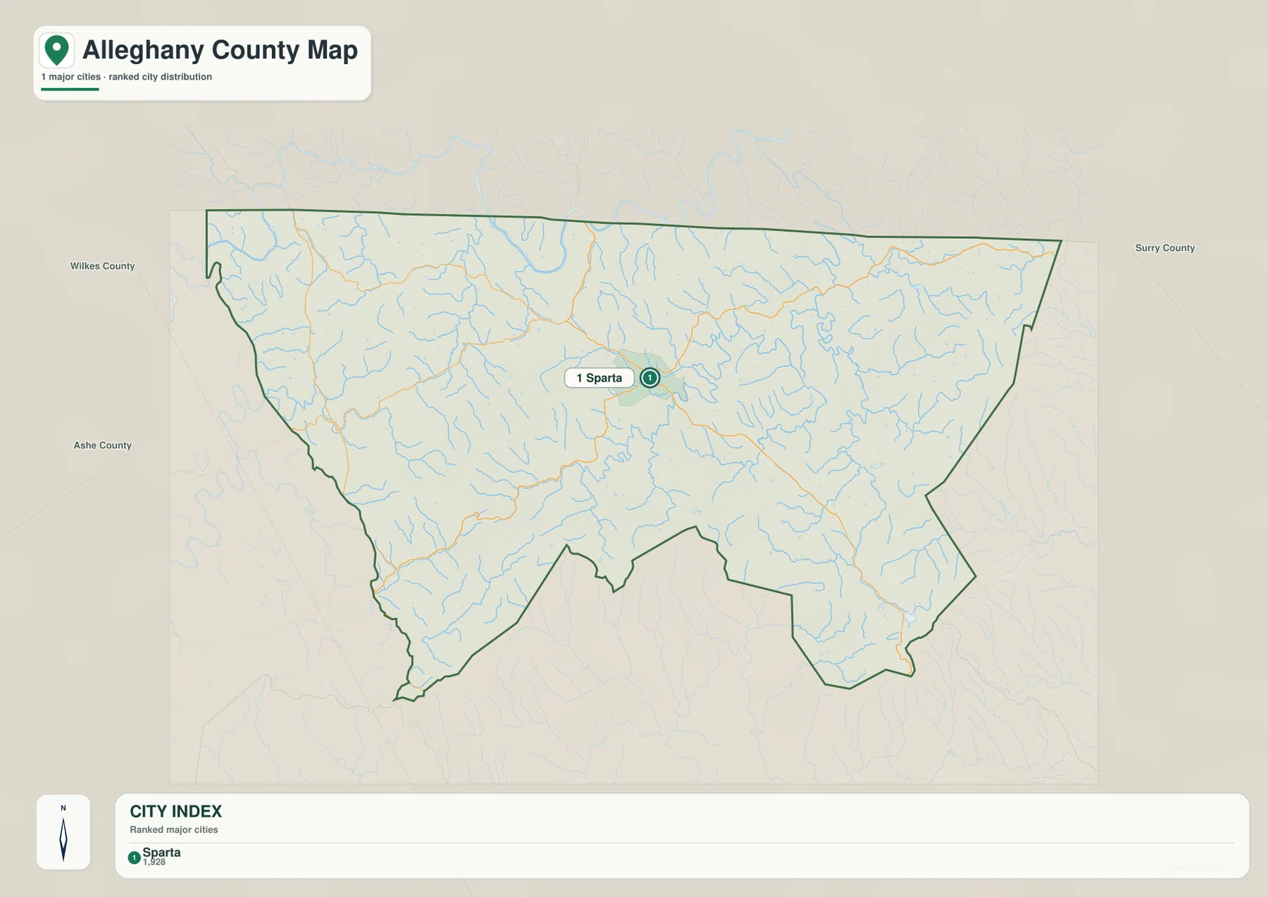
The city map simplifies that same relationship. Its city index identifies Sparta as the major city reference and places a single ranked marker near the center of the county. With most competing labels removed, a reader can quickly show where the county seat lies before moving to a more detailed road, water, demographic, or facility map. This is especially helpful in presentations or reports where the audience needs a clean geographic reference rather than a dense set of local labels.
New River, Little River, and the smaller mountain streams
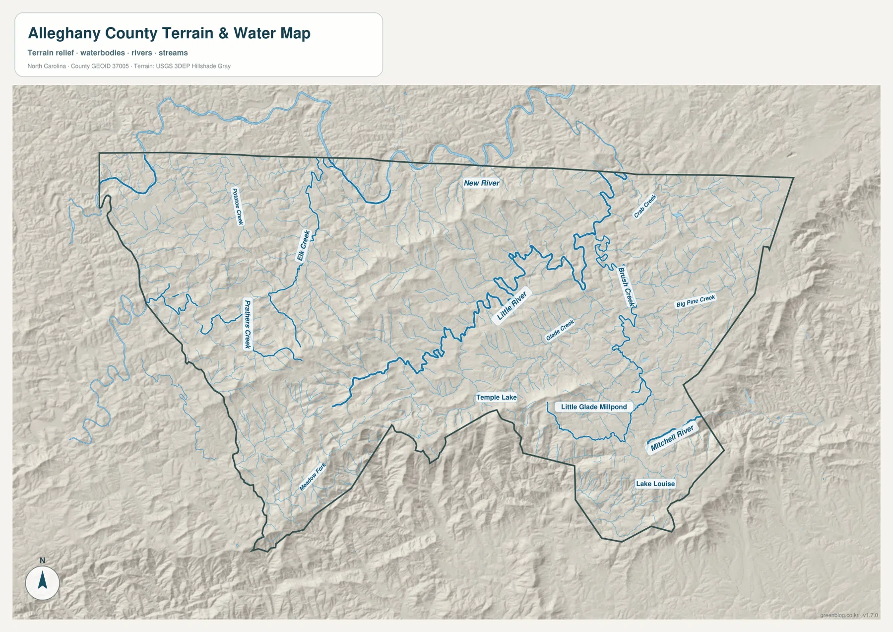
The terrain and water map contains the most detailed natural information in the package. New River is labeled near the northern part of the county, close to the Virginia side, while Little River winds across the interior. The larger channels are joined by many shorter creeks that occupy separate valleys. Among the named features visible on the map are Elk Creek and Prathers Creek toward the west, along with Brush Creek, Big Pine Creek, Glade Creek, and Mitchell River farther east and southeast.
Several smaller water bodies are also labeled. Temple Lake appears near the southern interior, Little Glade Millpond lies farther east, and Lake Louise is shown near the southeastern part of the county. These features should not be treated as though they are equal in size to the rivers. Their value on this map is local orientation: they help a reader connect a named water body with the nearby valleys and county boundary.
The shaded relief behind the water network explains why the drainage looks so intricate. Ridges and hollows repeat across the county, and the streams occupy the lower routes between them. Little River is especially useful as an interior reference because its winding course cuts through the middle of the map, while the eastern creeks show how water is divided among several smaller valleys. New River, by contrast, provides a strong northern reference near the state line.
Reading Alleghany beside Ashe, Wilkes, and Surry counties
A county map becomes easier to place when the surrounding names are visible. Ashe County is to the west, Wilkes County is to the south, and Surry County is to the east, while Virginia lies directly north. The city map prints those three North Carolina neighbors outside the Alleghany boundary, making the regional position clear without requiring a full state map. That is useful when Sparta is being compared with other county seats or when a larger northwestern North Carolina route is being planned.
The southern and southeastern boundary is much more irregular than the state-line edge. The existing package description also notes that the Blue Ridge Parkway follows part of the southeastern rim. That detail provides useful regional context, but the supplied maps are not intended as a dedicated parkway guide. For map reading, the larger point is that Alleghany belongs to a connected group of mountain counties where roads and waterways often follow terrain rather than a rectangular survey pattern.
Which Alleghany County map fits the task?
Use the general county map when the question involves the county outline, Sparta, numbered roads, or broad travel direction. It gives the strongest balance between human and physical features because roads and streams are visible together. It can also serve as the first figure in a report before more specialized data are introduced. For individual addresses, parcels, or street-by-street navigation, however, a more detailed local mapping source would be needed.
The city map is better when only the location of Sparta matters. Because it reduces the amount of information on the page, the county seat does not compete with numerous labels. The terrain and water map serves the opposite purpose: it adds detail where the natural setting matters. It is the better choice for comparing New River and Little River, locating the named creeks and small lakes, or showing why the county’s mountain relief affects the shape of the water network.
For teaching or presentation use, the maps can be introduced in that order: first the county boundary and roads, then Sparta as the settlement reference, and finally the water and terrain layer. The sequence avoids repeating the same explanation three times. It also lets the audience see how a simple administrative outline becomes a more detailed picture once roads, streams, and relief are added.
Details worth checking before using the files
The county map is designed for county-scale reference, so the labels that matter most are the ones that remain legible at that scale. Sparta is prominent, the numbered highway shields are easy to identify, and the county boundary is drawn strongly enough to separate Alleghany from the surrounding area. Numerous small streams are present, but the map does not attempt to name every one of them. That restraint keeps the road network readable.
The terrain and water map takes the opposite approach by giving water features stronger emphasis. Named rivers and creeks are easier to follow against the shaded land surface, and the small lakes provide additional local reference points. When the map is used in a document, it is helpful to keep the caption or nearby text focused on the feature the reader is supposed to notice rather than listing every label on the page.
The downloadable versions are high-resolution A3 JPG files, while the images embedded in the article are web previews. The larger files are more appropriate for printing, offline viewing, or placing into a document where the labels need to remain clear. Because the ZIP contains the same three map types described here, there is no need to guess which files will be included after clicking the download button.
Frequently Asked Questions
Where is Sparta on the Alleghany County map?
Sparta is shown near the middle of the county and is the county seat. On the general map, several numbered roads meet or pass near Sparta, making it the easiest starting point for orientation. The city map simplifies the view further by emphasizing Sparta without the same amount of road and terrain detail.
How do New River and Little River differ on the map?
New River appears near the northern side of the county close to the Virginia boundary, while Little River winds through the interior. The terrain and water map also shows numerous creeks joining different valleys, so the two rivers work as separate geographic references rather than one continuous feature.
What is included in the downloadable Alleghany County ZIP?
The download contains three high-resolution A3 JPG files: the general county map, the city map, and the terrain and water map. The WebP images in the article are lighter previews for on-screen viewing, while the JPG files are intended for saving, printing, or use in documents.
Sources and reference data
- NCpedia: Alleghany County geography and county information
- U.S. Census Bureau TIGER/Line boundary data
- USGS National Hydrography water data
- USGS 3D Elevation Program elevation data
Map File Information
Download the Alleghany County general map, city map, and terrain-and-water map as high-resolution A3 JPG files. The ZIP contains the same three map types shown in this article.
- Included Files: General county map, city map, and terrain-and-water map
- File Type: Three high-resolution A3 JPG files in one ZIP archive
- Intended Use: Printing, education, presentations, and map-based projects
Related Maps
Green Map creates custom-edited map images using open geographic data sources such as geoBoundaries, Natural Earth, OpenStreetMap, and government open data. These maps are edited visual materials, not raw data files, and are provided for education, documents, presentations, and graphic reference.