The Sarasota County Map covers Florida’s southwest Gulf Coast from Sarasota Bay and Venice to the broad inland area of North Port. This page explains the county’s main roads, city positions, boundaries, and Myakka River waterways, and you can download the matching high-resolution A3 JPG map files in one ZIP archive. Sarasota sits near the bay in the northwest, Venice lies farther south along the coastal corridor, and North Port spreads across a much larger inland area in the southeast, with barrier islands, creeks, bays, and two major north-south road corridors connecting the picture.
The article uses a county map for places, roads, and boundaries; a city-connections map with North Port as the hub; and a terrain-and-water map emphasizing the Myakka system and coastal waters. The WebP versions are convenient for reading on the page, while the downloadable JPG files preserve more detail for printing, worksheets, presentations, and offline reference.
Table of Contents
From Sarasota Bay to Venice and North Port: cities and road corridors
The general county map makes the northwest corner a natural place to begin. Sarasota, the county seat, sits close to Sarasota Bay, with Longboat Key and Siesta Key along the Gulf side and mainland places such as Fruitville, Bee Ridge, and Palmer Ranch extending inland. Hospitals and public facilities appear in this northern urban area, and the street pattern is visibly denser than it is across much of the eastern interior. The county boundary then stretches a long way south, so the map is not dominated by a single compact metropolitan core.
Two north-south transportation patterns help organize the county. The near-coastal corridor follows the chain of Sarasota, Osprey, Laurel, Venice, South Venice, and Englewood, while I-75 runs farther inland. State Road 72 crosses from the coast toward the interior, and the map also marks 780 heading east through Fruitville toward Old Miakka. These east-west roads are important because they show that the county is not simply a thin coastal strip: the developed Gulf side and the broad interior are tied together by a limited number of major crossings.
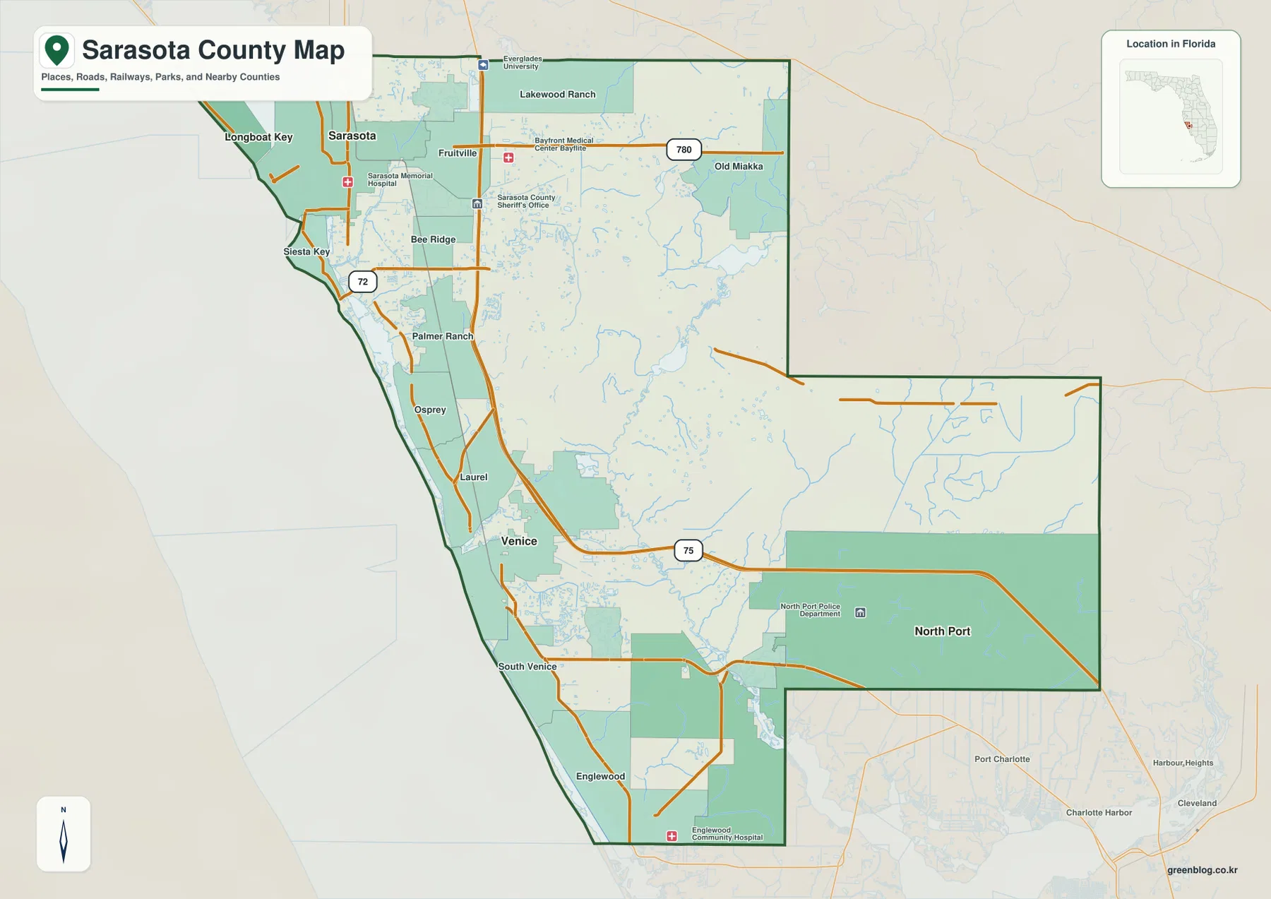
South of Sarasota, the map passes Osprey and Laurel before reaching Venice. South Venice continues below the city, and Englewood appears near the lower Gulf side close to the Charlotte County line. This sequence of places creates a long coastal settlement corridor, but North Port does not sit directly on that same line. It occupies a large block to the east and southeast, separated from the Gulf by interior neighborhoods, waterways, and the road network.
North Port’s large municipal footprint is one of the most obvious features on the county map. Its boundary covers far more land than the compact urban areas of Sarasota or Venice, which can make the city look disproportionately dominant if the map is read only by area. The southern edge of the map also shows Port Charlotte and Charlotte Harbor outside Sarasota County, providing useful orientation for the county line. Those nearby labels are context, not part of the Sarasota County municipal system.
The map is also useful for separating coastal islands from mainland places. Longboat Key and Siesta Key lie on the Gulf side of bays and channels, so their access depends on bridges rather than a continuous mainland road. That matters when comparing map distance with actual travel. A place can appear close to Sarasota or another mainland community while still requiring a specific bridge approach and a longer road path.
North Port as the hub on the city-connections map
The city-connections map removes most local labels and uses North Port as the reference point. Sarasota is marked to the northwest and Venice to the west-northwest. The map lists about 30 miles from North Port to Sarasota and about 17 miles from North Port to Venice. These figures are straight-line distances between the mapped city points, not driving distances measured along I-75, U.S. 41, or local streets. They are best used to compare relative spacing and direction.
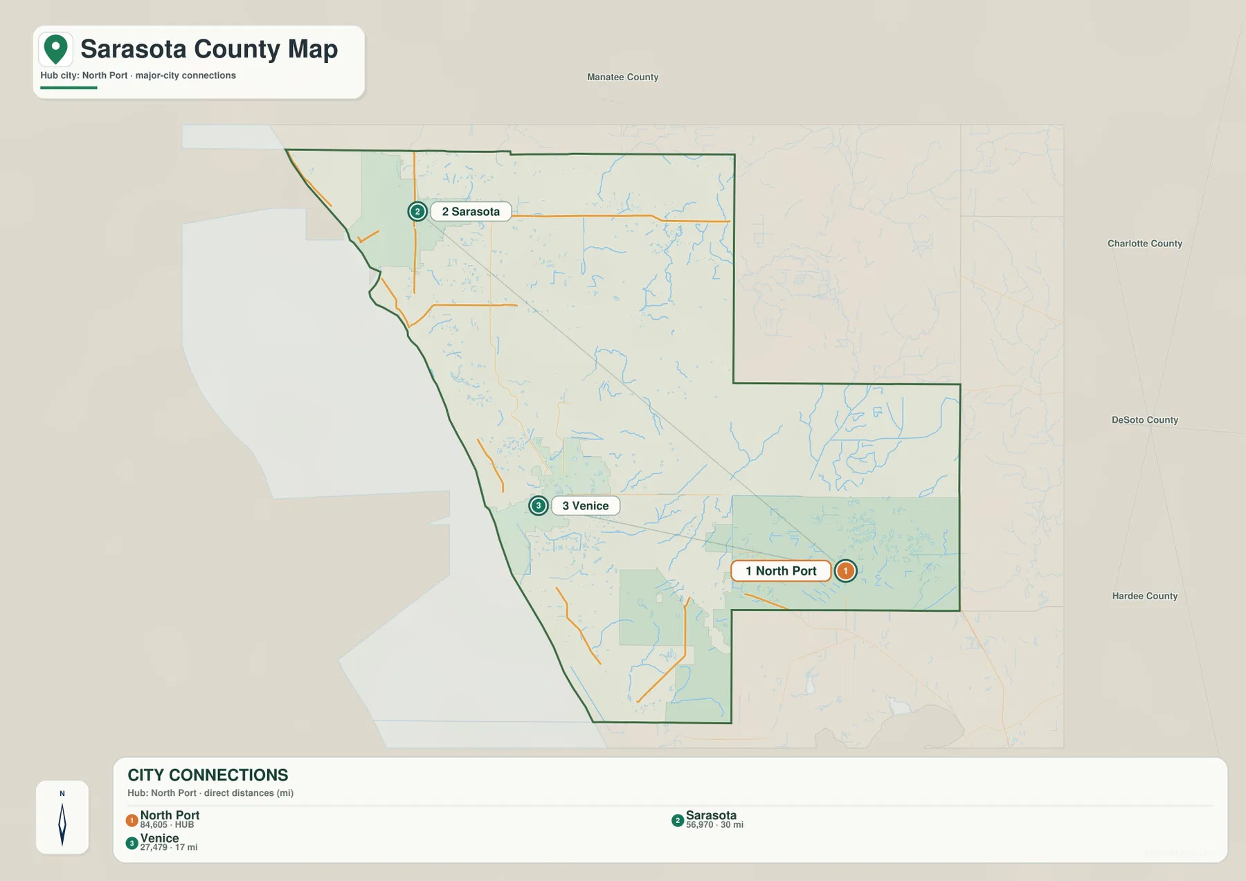
The simplified view highlights a geographic fact that can be lost on a detailed road map: the three cities do not form one evenly spaced coastal line. Sarasota is far to the northwest, Venice is much closer to North Port, and North Port sits inland across a wide southeastern section of the county. That shape helps explain why travel between North Port and Venice can feel different from travel between Sarasota and Venice even when all three are commonly discussed as part of the same county.
A straight-line connector should not be treated as a route recommendation. To travel from North Port to Venice, a driver must use the actual street network rather than follow a 17-mile diagonal across the map. A trip to Sarasota likewise depends on the available north-south roads and the point of origin within North Port’s very large boundary. The city map is therefore a quick orientation tool; the general county map is the better choice when the road pattern matters.
The differences in municipal footprint also deserve attention. Sarasota is the county seat and the best-known northern center, yet its incorporated area appears much smaller than North Port’s. Venice is another compact coastal municipality. North Port, by contrast, covers a broad inland territory. Map area should therefore not be read as a direct measure of downtown size, population density, or importance. It reflects municipal boundaries as well as settlement form.
The Myakka River, coastal bays, and southern creeks
The terrain-and-water map shifts attention away from roads. Sarasota Bay is labeled in the northwest, while Dona Bay appears farther south near the Venice area. Across the center and southeast, the Myakka River becomes the main named river feature. Deer Prairie Creek feeds through the interior nearby, and smaller channels branch across the low landscape. This water network helps explain why the eastern half of the county looks more open and less continuously urbanized than the Gulf-side corridor.
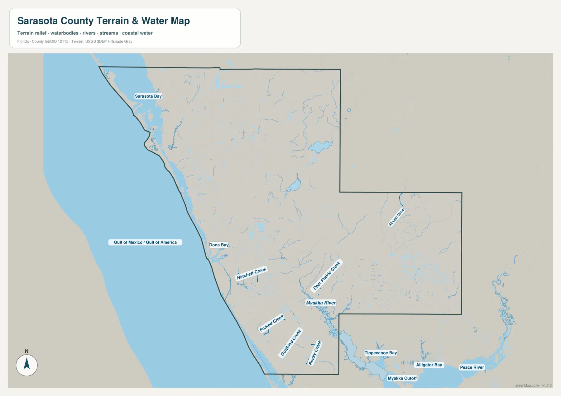
Several named creeks appear near the southwest coast, including Hatchett Creek, Forked Creek, Gottfried Creek, and Rookery Creek. They reach toward Gulf-side bays and estuarine water rather than forming one simple river channel. Farther south, the map labels Tippecanoe Bay, Alligator Bay, and the Myakka Cutoff. Together these features show that the southern county edge is shaped by a mix of freshwater drainage, tidal bays, and low coastal terrain.
Slough Canal appears near the eastern side of the map, while the Peace River is labeled beyond the county’s southeastern side as surrounding water context. The Peace River should not be described as Sarasota County’s central river on the basis of this map. Within the county, the Myakka River is the stronger organizing feature, especially when the map is compared with North Port’s broad municipal area and the less dense interior road pattern.
The background also includes generalized terrain relief, but it is not a survey-grade elevation product. Sarasota County is dominated by low, gently changing terrain rather than major mountain relief, so the shading is most useful as visual context for waterways and landform rather than for reading precise heights. The map is likewise not a flood-zone, depth, navigation, parcel, or legal-boundary map. Flood insurance, boating, engineering, and property decisions require current information from the responsible agencies.
Reading the road map and water map together
For a first pass, locate Sarasota, Venice, and North Port on the general county map and then compare the two major north-south travel patterns. The Gulf-side communities cluster closer to the U.S. 41 corridor, while I-75 runs inland. Then switch to the water map. The change in emphasis makes it easier to see why the county’s eastern and southern areas have a different settlement pattern: rivers, creeks, wetlands, and bays occupy more of the visual field, and large areas have fewer closely spaced place labels.
The same comparison helps with the barrier islands. On the general map, Longboat Key and Siesta Key are easy to place in relation to Sarasota and the mainland road network. On the water map, the bays and channels separating those islands from the mainland become much more obvious. Neither map alone answers every question. The general map is stronger for place names and roads, while the water map is stronger for understanding why the coastline and interior drainage shape travel and settlement.
The city-connections map has a narrower purpose. Use it when you want a quick answer to how Sarasota and Venice sit relative to North Port. The 17-mile and 30-mile labels should be read as direct distances only. If the question is how to drive between the cities, return to the road map and use current navigation information. If the question is how the Myakka River or coastal bays relate to those cities, the terrain-and-water map is the more useful reference.
For printing, the A3 JPG files in the ZIP preserve more detail than the body WebP images. Choose the county map when roads, places, and boundaries are the priority; choose the city-connections map for a simple three-city comparison; and use the water map when the Myakka system, creeks, bays, and Gulf-side water are the main subject. The three files complement one another rather than repeating the same information.
Frequently Asked Questions
Why does North Port cover so much more area on the map than Sarasota or Venice?
North Port has a very large incorporated boundary across southeastern Sarasota County. Sarasota and Venice have more compact coastal municipal footprints, while North Port includes broad inland residential areas along with less densely developed land and waterways. The larger mapped area does not mean that every part of North Port is a dense urban center.
Are the 17-mile and 30-mile city distances driving distances?
No. The city-connections map uses straight-line distance from North Port to the mapped city points: about 17 miles to Venice and about 30 miles to Sarasota. Actual road distance and travel time depend on the street network, the part of North Port where a trip begins, traffic conditions, and the chosen route.
Can the Myakka River and coastal water map be used as a flood map?
No. The terrain-and-water map is designed to show the relative locations of rivers, creeks, bays, coastal water, and generalized terrain. It does not show regulatory flood zones, water depth, parcel boundaries, or engineering-grade elevation. For flood, insurance, property, or emergency planning, use the latest official county and federal resources.
Map File Information
Download the Sarasota County county map, city-connections map, and terrain-and-water map as high-resolution A3 JPG files in one ZIP archive.
- Included Versions: county map, city-connections map, water map
- Included Files: 3 high-resolution A3 JPG files
Related Maps
- Arcadia Roads and Peace River | DeSoto County Florida Map
- Baker County Florida Map
- Between the Aucilla and Withlacoochee: Madison County Florida Map
Sources and References
For county statistics and local information, see the U.S. Census Bureau Sarasota County QuickFacts and the Sarasota County official website. For road and county-map reference, use the Florida Department of Transportation county highway maps. Additional context for the Myakka River landscape is available from Florida State Parks: Myakka River State Park.
Green Map creates custom-edited map images using open geographic data sources such as geoBoundaries, Natural Earth, OpenStreetMap, and government open data. These maps are edited visual materials, not raw data files, and are provided for education, documents, presentations, and graphic reference.