Hardee County sits in south-central inland Florida, with Wauchula near the middle of a north–south line of communities that also includes Bowling Green and Zolfo Springs. You can download the three high-resolution A3 JPG maps from this page together in one ZIP archive. U.S. 17 links the county’s three incorporated municipalities, while the Peace River winds through the same broad central area and receives several named creeks. The maps show the county boundary and road network, the relative positions of Bowling Green, Wauchula, and Zolfo Springs, and the main water features used throughout the article.
The easiest way to orient yourself is to separate the central town sequence from the wider rural county. Bowling Green is north of Wauchula, and Zolfo Springs is south of it. Wauchula is the county seat and the place where SR 64 crosses the U.S. 17 corridor, so it is a useful reference for both east–west and north–south travel. Names such as Ona, Fort Green, Gardner, Limestone, and Lemon Grove describe other rural areas and should be tied to a nearby road, creek, or municipality rather than treated as if every label were another city.
The package includes three body maps: a county map, a city-connections map, and a terrain-and-water map. The county view carries the most road and place information. The city view strips away much of that detail so the relative position of Bowling Green, Wauchula, and Zolfo Springs is easy to compare. The water view makes the Peace River, its tributaries, and smaller named ponds and lakes much more prominent. These are geographic reference maps, not parcel surveys, flood determinations, navigation charts, or engineering products.
Table of Contents
U.S. 17 connects Bowling Green, Wauchula, and Zolfo Springs
On the general county map, U.S. 17 is the clearest organizing road. Bowling Green appears in the north, Wauchula in the central part of the county, and Zolfo Springs farther south. Wauchula is also marked near the Hardee County Courthouse, reinforcing its role as the government center. A reader who starts with those three places can quickly decide whether a destination belongs to the northern, central, or southern part of the county before looking for smaller rural roads.
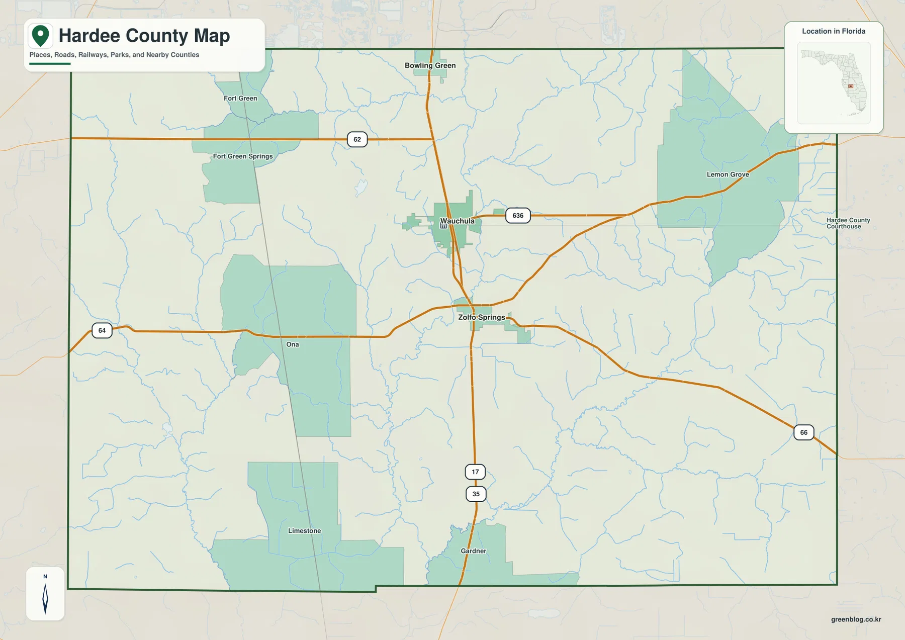
The main east–west roads branch from different parts of that central line. SR 62 heads west from the Bowling Green area. SR 64 crosses Wauchula and continues toward Ona on the western side, while the road also provides an eastward reference toward the Highlands County side. Near Zolfo Springs, SR 66 turns east, and U.S. 17 continues south. Because these roads leave the central corridor at different locations, the most practical question for a rural destination is often not simply “How far is it from Wauchula?” but “Which town and which east–west road should I use first?”
The map also labels Fort Green and Fort Green Springs in the northwest, Ona west of Wauchula, Limestone in the southern part of the county, and Lemon Grove in the eastern interior. These labels help divide a large rural area into recognizable parts, but they do not all represent incorporated municipal governments. When an address or local description uses one of these community names, confirm the actual jurisdiction through the county’s current GIS or other official records if city limits, permits, zoning, or services matter.
Hardee County shares broad boundaries with Polk County to the north, Highlands County to the east, DeSoto County to the south, and Manatee County to the west. The verified material in the package also notes a point contact with Hillsborough County at the extreme northwest corner. That small contact can disappear visually at a reduced scale, so the general map is best for regional orientation while an official adjacency or GIS source should be used when the exact legal relationship matters.
The city map shows a compact town sequence, not continuous urban development
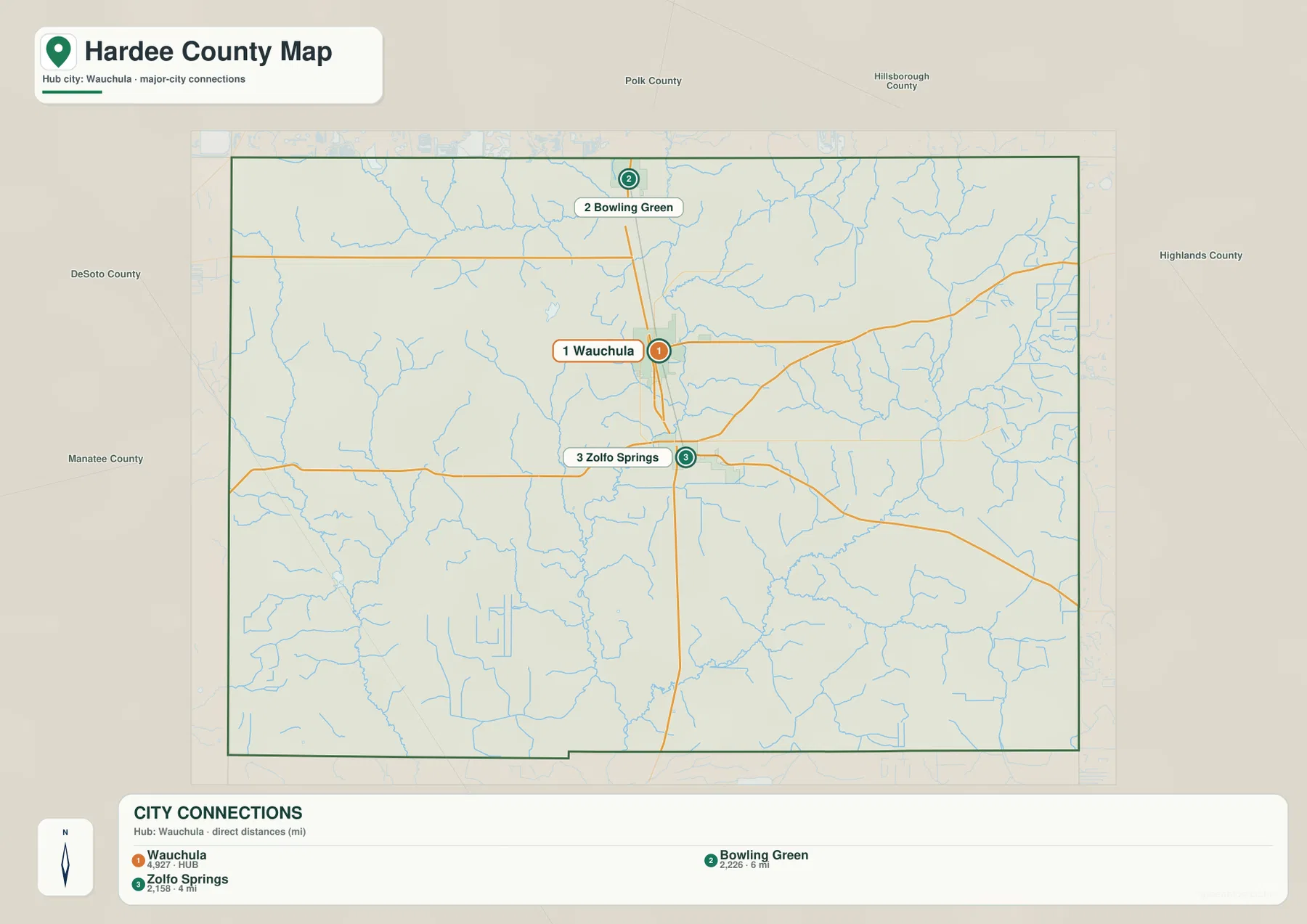
The city-connections map reduces the county to its three incorporated municipalities and makes Wauchula the hub. Bowling Green is shown to the north and Zolfo Springs to the south. The connector distances printed on this map are straight-line distances, not road mileage. They are useful for comparing relative spacing, but actual driving follows highways, intersections, bridges, and local access roads and can therefore be longer than the direct distance shown on the graphic.
This simplified map is helpful when you need to answer a directional question quickly. A northern destination near Payne Creek or Fort Green can be related first to Bowling Green. Wauchula is the clearest anchor for the courthouse, SR 64, and central services. A destination near Gardner, Charlie Creek, or the DeSoto County side can be narrowed by starting with Zolfo Springs. After that first choice, the general county map provides the local road and place labels that the city map intentionally leaves out.
The three municipalities may look close together on a county-scale image, but Hardee is not one continuous built-up strip. The existing verified article describes broad areas of farms, pasture, wetlands, and rural roads outside the municipal centers. That distinction matters when planning a field visit or preparing a printed reference sheet. A city-to-city view is ideal for the main settlement pattern; it should not be mistaken for a complete representation of where homes, farms, public roads, or services are located across the county.
Peace River and named creeks provide the strongest natural reference points
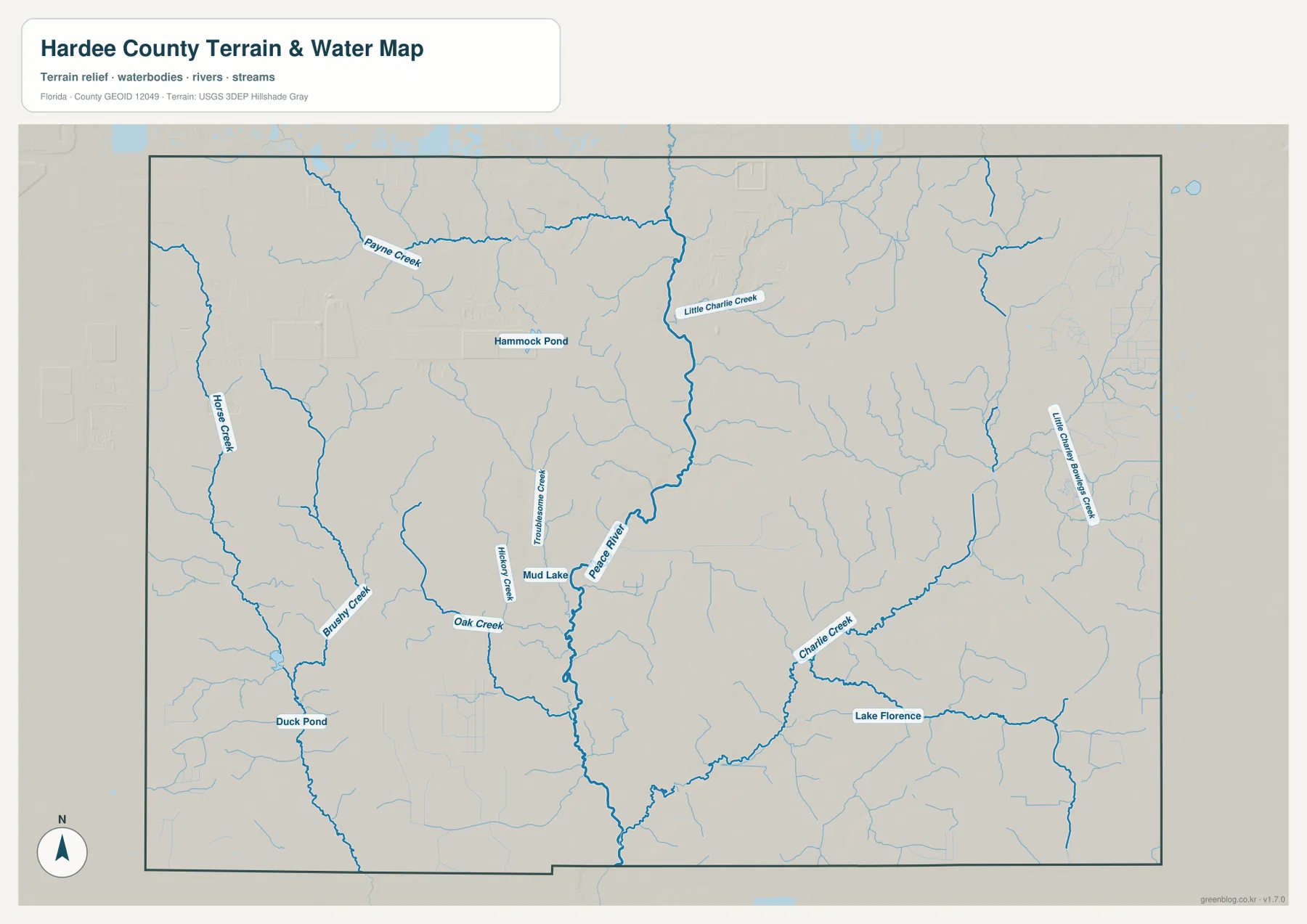
The Peace River is the dominant blue feature on the water map, running through the central county toward the south. It shares the broad north–south orientation of U.S. 17, but the two should never be treated as the same corridor. The river meanders and can be crossed only where roads provide bridges. A destination on the opposite bank may look close in a straight line and still require a much longer road approach, so a useful printed route note should include the intended crossing rather than only the nearest town.
Several tributaries make different parts of the rural county easier to distinguish. Payne Creek is prominent in the north. Little Charlie Creek approaches the central river from the north-central area. Horse Creek and Brushy Creek mark the west, while Oak Creek, Hickory Creek, and Troublesome Creek appear in the central and southwestern part of the map. Charlie Creek is a major feature in the southeast, and Little Charley Bowlegs Creek appears farther east. These names are useful because they provide geographic anchors in areas where city labels are sparse.
The map also identifies smaller water bodies such as Hammock Pond, Mud Lake, Duck Pond, and Lake Florence. Their presence can help a reader match a local description to the correct part of the county, but a named pond or lake should not be assumed to have public access. Likewise, a blue line on this map does not establish a navigable channel, a legal property boundary, or a safe crossing. The purpose of the water layer is to show where the named water features are and how the tributary network relates to the larger Peace River system.
The verified source material links Payne Creek with the Bowling Green area and places the Charlie Creek confluence with the Peace River near Gardner. Horse Creek begins near the unusual northwest point where Hardee, Polk, Manatee, and Hillsborough meet and then continues through the western part of the region before joining the Peace River farther south in DeSoto County. Those relationships make the creeks more than decorative map labels: they help distinguish the northern, western, and southern parts of a county whose built-up places are concentrated along a relatively narrow central road corridor.
The background of the terrain-and-water map suggests gentle relief, but the package does not include a separate elevation map and no survey-grade heights should be inferred from this image. It is also not a flood-hazard product. Flood zones, current river stage, bridge conditions, boating access, emergency routes, and property lines require current information from the responsible county, transportation, water-management, or land-record agency.
Rural Hardee is easier to navigate by pairing a place name with a road or creek
Ona is a good example. It lies west of Wauchula along SR 64, so “west of Wauchula on SR 64 near Ona” is a much stronger location description than the community name alone. Fort Green and Fort Green Springs work similarly for the northwestern countryside, while Limestone and Lemon Grove help break up other parts of the county that lack large municipal centers. When the general map does not show a small local road, the combination of nearest incorporated town, state road, and named water feature can narrow the search area before a detailed map is opened.
Agriculture is also part of the landscape behind these rural references. The verified package cites the 2022 Census of Agriculture county profile, which reported about $229 million in agricultural products sold in Hardee County and described a mix that includes citrus, cattle, pasture, and other crops. A reference map cannot tell you which crop occupies a particular field or whether a straight farm lane is public. Parcel boundaries, public-road status, land use, and permission to enter private property must be checked through current official records.
The existing source material also places Hardee within the southern reach of Florida’s Bone Valley phosphate region. Mining, reclamation, water-management cells, and restored ground can change the appearance of land over time. For that reason, a static background or older aerial image may not match current conditions exactly. If a project depends on access, present land condition, or regulatory status, compare the reference map with the latest county and Florida Department of Environmental Protection information rather than assuming the mapped background is current to the day.
Hardee County was created in 1921 when the former DeSoto County was divided, and Wauchula became the county seat. That history provides useful context for old maps, but the modern U.S. 17 road pattern should not be treated as identical to historic railroad or highway alignments. When comparing a historic document with the present map, check the date and remember that road classifications, municipal limits, and land use can change even when familiar place names remain.
Choose the Hardee County map by the question you need to answer
- County map: best for seeing Wauchula, Bowling Green, Zolfo Springs, U.S. 17, SR 62, SR 64, SR 66, rural place labels, and the county outline together.
- City-connections map: best for comparing the relative position of the three incorporated municipalities and their straight-line spacing from Wauchula. It is not a driving-distance map.
- Terrain-and-water map: best when the Peace River, creeks, ponds, lakes, or a river crossing matters more than the road network.
For a classroom handout or presentation, choose the map that matches the information you want the reader to notice. For a field reference, it helps to write down the nearest U.S. 17 municipality, the east–west road, and whether the route crosses the Peace River or a tributary. Turn-by-turn travel, emergency evacuation, flood decisions, public access, property research, and land transactions all require current operational or legal sources in addition to this static overview.
The download archive contains three high-resolution A3 JPG files corresponding to the maps used in the article. The file name is hardee_county_florida_3_map_jpg.zip. It includes the general county map, the city-connections map, and the terrain-and-water map as separate JPG images, making the ZIP more convenient than the web previews when you need a larger printable copy for a document, lesson, or presentation.
Frequently Asked Questions
What is the north-to-south order of Hardee County’s three municipalities along U.S. 17?
From north to south, the sequence is Bowling Green, Wauchula, and Zolfo Springs. Wauchula sits in the middle and is also the county seat, with SR 64 crossing the central corridor there. For a rural destination, first choose the nearest one of these three places and then identify the east–west road or named creek that leads toward the correct part of the county.
Do the Peace River and U.S. 17 follow the same route through Hardee County?
No. They share a broad north–south orientation through the central county, but the Peace River meanders while U.S. 17 follows the road network. A river destination may require a specific bridge and approach road, so the nearest U.S. 17 town alone is not enough to determine access.
Can the terrain-and-water map be used for flood risk or river-access decisions?
No. It is a geographic reference showing the location of the Peace River, tributaries, ponds, lakes, and the county outline. Flood zones, current river stage, public access, navigation conditions, and property boundaries require current information from the responsible county, water-management, transportation, or land-record agency.
Map File Information
Download the high-resolution A3 JPG versions of the Hardee County maps used on this page in one ZIP archive.
- Included Files: County map, city-connections map, terrain-and-water map
- File Type: ZIP containing three high-resolution A3 JPG files
Related Maps
- Arcadia Roads and Peace River | DeSoto County Florida Map
- Baker County Florida Map
- Blountstown, SR 20, and the Apalachicola River | Calhoun County Florida Map
Sources
- Hardee County official website
- Florida Department of Transportation county general highway maps
- Southwest Florida Water Management District Peace River tributaries
- USDA 2022 Census of Agriculture Hardee County profile
- Florida Memory 1921 Hardee County creation act
- U.S. Census Bureau 2024 county adjacency file
Green Map creates custom-edited map images using open geographic data sources such as geoBoundaries, Natural Earth, OpenStreetMap, and government open data. These maps are edited visual materials, not raw data files, and are provided for education, documents, presentations, and graphic reference.