Gulf County is easier to understand when the map is read from south to north rather than as a single strip of Florida coast. Port St. Joe sits beside St. Joseph Bay near the southern end of the county, while Wewahitchka lies well inland to the north near the Chipola River and Dead Lakes area. Between them are long stretches of forest, wetlands, smaller communities, and water crossings. This page provides a county road-and-boundary map, a city-location map, and a water-and-terrain reference map, and the matching high-resolution A3 JPG files are available together in a downloadable ZIP.
The key organizing route is State Road 71. It links Port St. Joe and Wewahitchka through the middle of Gulf County, while U.S. 98 handles much of the east-west coastal movement around Port St. Joe. Farther south, local roads split toward Indian Pass, Cape San Blas, and the St. Joseph Peninsula. On the eastern side, the Apalachicola River and its broad lowland system create a very different edge from the bay and barrier-peninsula landscape in the southwest.
Each map below is meant for a different question. The county map is the best starting point for roads, neighboring counties, and named places. The city map makes the separation between Port St. Joe and Wewahitchka immediately visible. The water map gives much more attention to St. Joseph Bay, the Apalachicola River, creeks, channels, and other water features. These are reference maps for location and general geographic context; they are not parcel surveys, legal boundary determinations, flood maps, engineering elevation products, or navigation charts.
Table of Contents
A long county between St. Joseph Bay and the river lowlands
Gulf County has a distinctive shape because water defines so much of its southern and eastern geography. Port St. Joe occupies the bay side of the county and functions as the county seat. Wewahitchka is the other incorporated city and sits much farther north. The county meets Bay County on the west, Calhoun County to the north, Liberty County toward the northeast, and Franklin County along the east and southeast. The open coast and St. Joseph Bay form the southern setting, while the Apalachicola River system marks much of the opposite side.
- State: Florida
- County: Gulf County, FIPS 12045
- County seat: Port St. Joe
- Incorporated cities: Port St. Joe and Wewahitchka
- Neighboring counties: Bay, Calhoun, Liberty, and Franklin
- 2020 land area: 553.45 square miles
- 2020 census population: 14,192
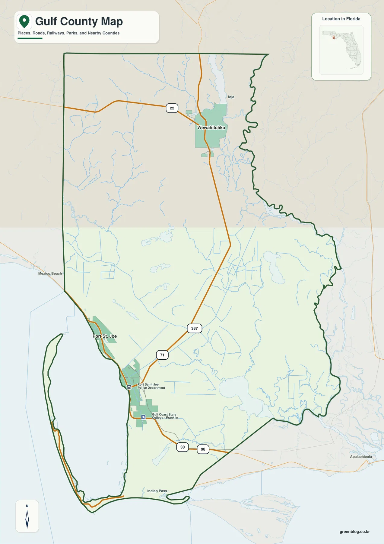
On the county map, SR 71 is the clearest north-south line. It leaves Port St. Joe and continues toward Wewahitchka, making it the most useful road to trace when comparing the county’s two main population centers. U.S. 98 crosses the Port St. Joe area and continues along the coastal side of the county. SR 22 reaches Wewahitchka from the west. Near the southern coast, the route pattern becomes more branched because destinations on Cape San Blas, Indian Pass, and the St. Joseph Peninsula cannot be reached by drawing a straight line across the bay.
This is also where county boundaries matter. Mexico Beach is close to the western Gulf County beach corridor, but it is in Bay County. On the east, the Apalachicola River and associated wetlands make the border with Franklin and Liberty counties look less like a simple road-to-road transition. A place can appear close across a waterway while the practical driving route goes in another direction to reach a bridge or paved road. The map is most useful when roads and water are read together rather than treating the county outline as the only piece of information.
U.S. Census Bureau QuickFacts reports 14,192 residents in the 2020 census and a 2020 land area of 553.45 square miles. The July 1, 2025 population estimate is 15,943. Those numbers describe a lightly populated county with settlements concentrated in a few places rather than a continuous urban corridor. A large blank-looking area on the map is therefore not necessarily missing data; much of the county is rural land, forest, wetland, or low-density development between the named communities.
Port St. Joe and Wewahitchka anchor opposite ends of the city map
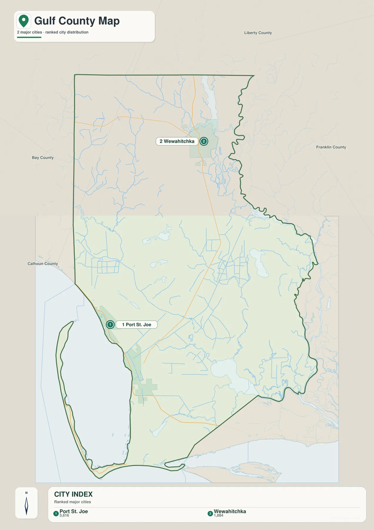
The city map simplifies the county to its two incorporated cities, which makes the settlement pattern much easier to read. Port St. Joe is positioned near St. Joseph Bay in the southwest part of the county, while Wewahitchka is far to the north. There is no chain of large incorporated places filling the middle. That separation explains why SR 71 matters so much: it is not merely one road among many on the map but the basic route connecting the county seat with the northern city.
Port St. Joe works well as the southern reference point because several travel directions meet there. U.S. 98 leads toward the beach communities to the west and toward Franklin County to the east. Roads branching south and southeast lead toward Indian Pass, Cape San Blas, and the St. Joseph Peninsula. Wewahitchka is the northern reference point for SR 71, SR 22, and access toward the Dead Lakes and lower Chipola River area. A traveler headed to the coast and someone headed to the northern freshwater system can both be in Gulf County while using very different road networks.
Postal names can make this geography confusing if they are treated as municipal boundaries. A Port St. Joe mailing address may be used for a location well outside the compact downtown area, including addresses along the peninsula. Meanwhile, a nearby coastal place may fall in another county. For property questions, permits, taxes, evacuation zones, or a precise city limit, the county’s official GIS is the better source because it displays addresses, streets, municipal limits, parcels, flood zones, evacuation zones, and evacuation routes.
St. Joseph Bay, creeks, and the Apalachicola side of the county
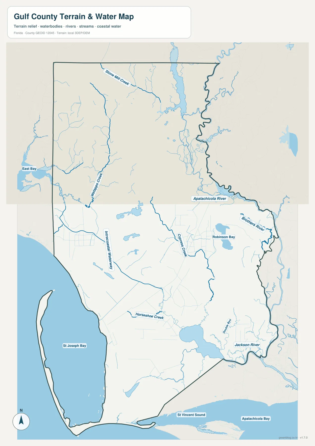
The water map explains why Gulf County can feel like several different landscapes within one boundary. St. Joseph Bay fills much of the southwest side and is partly sheltered by the long St. Joseph Peninsula. Across the county, the Apalachicola River runs along the eastern side, with waterways such as Brothers River and Jackson River appearing near the broader river lowlands. Wetappo Creek, Cypress Creek, Horseshoe Creek, the Intracoastal Waterway, and smaller channels fill in the middle. The result is a map where water repeatedly interrupts what might otherwise look like short cross-county routes.
St. Joseph Bay is not simply another river mouth. Florida’s Department of Environmental Protection describes the St. Joseph Bay Aquatic Preserve as more than 55,000 acres of submerged lands with extensive seagrass habitat, and notes that no large freshwater river flows directly into the bay. That helps explain the bay’s distinct setting compared with the freshwater systems to the north. The peninsula forms a long outer edge on the bay’s west side, while Port St. Joe sits on the inner shore where roads and developed areas are easier to reach.
North of Wewahitchka, Dead Lakes adds another type of water landscape. The Florida Fish and Wildlife Conservation Commission describes it as a 6,700-acre lake on the Chipola River in Calhoun and Gulf counties. The Gulf County access is off SR 71 north of Wewahitchka. The lake is known for cypress snags and submerged stumps, which is a good reminder that a general water map is not a safe boating guide. It shows where the waterbody is and how it relates to roads and nearby places, but current navigation and on-the-water conditions require specialized information.
The terrain shading on this map should also be read carefully. Gulf County is part of the low-relief coastal plain, so dramatic mountain elevation is not the story here. Small changes in height can still matter locally, but the map is designed to show broad terrain context together with waterways, not survey-grade elevations. For flood zones, evacuation areas, or parcel-specific risk, use the official Gulf County GIS and current emergency information instead of inferring risk from the blue water features or background relief.
Road choices change quickly near the bay and peninsula
The southern part of Gulf County is where map-reading shortcuts most often fail. From Port St. Joe, the St. Joseph Peninsula can look extremely close across the bay, but the usable route follows roads around the water. CR 30A leads toward the Cape San Blas and Indian Pass area, and CR 30E continues along the peninsula toward T.H. Stone Memorial St. Joseph Peninsula State Park. Florida State Parks describes the peninsula as stretching about 20 miles, so the southern cape, the peninsula road, the park entrance, and the far northern section should not be treated as one single point.
The same principle applies on the western coast. U.S. 98 connects Port St. Joe with communities along the beach corridor, but a continuous line of houses or businesses does not mean every place is in Gulf County. County lines should be checked before using local government information. For the inland trip to Wewahitchka, SR 71 is the clearer guide; staying on a coastal route would not reflect the county’s actual north-south structure. SR 22 then provides a western connection from Wewahitchka toward Bay County.
Gulf County’s administrative history also fits the two-center map. The county was created from part of Calhoun County in 1925 with Wewahitchka as the county seat. Florida Memory notes that residents voted in 1964 to move the county seat to Port St. Joe. Today, Port St. Joe is the administrative center, yet Wewahitchka remains the incorporated city that organizes much of the northern side. The map therefore reflects a real historical and geographic division rather than a modern layout built around only one town.
Choose the map that matches the job
- County road and boundary map: best for locating Port St. Joe, Wewahitchka, U.S. 98, SR 71, SR 22, and neighboring county lines on one page.
- City-location map: best when the main goal is to show how the two incorporated cities sit at different ends of the county without extra detail competing for attention.
- Water and terrain map: best for comparing St. Joseph Bay with the Apalachicola River side and for seeing how creeks, channels, and coastal water affect the county’s layout.
For printing, a simple approach is to choose the version that emphasizes the feature you need instead of trying to force every detail onto one page. The download archive contains three high-resolution A3 JPG files matching the maps shown in the article. They are suitable for general reference, classroom work, presentations, trip planning, and local orientation. If the task involves legal parcel boundaries, engineering measurements, flood determinations, emergency routing, or boating navigation, pair these reference maps with the current official dataset for that purpose.
Frequently Asked Questions
What is the main road between Port St. Joe and Wewahitchka?
State Road 71 is the basic north-south connection between the two incorporated cities. U.S. 98 is more important for the Port St. Joe coastal corridor, while SR 22 connects with Wewahitchka from the west. Check current road conditions before travel, especially after severe weather or when heading onto smaller coastal roads.
Are Cape San Blas and the St. Joseph Peninsula the same place?
Not exactly. St. Joseph Peninsula refers to the long landform that shelters the western side of St. Joseph Bay, while Cape San Blas is used for the southern cape and surrounding area. A Port St. Joe mailing address can still be far from downtown, so peninsula destinations should be located by their actual road approach, particularly the 30A and 30E corridor.
Can the water map be used as a flood or boating navigation map?
No. It is a geographic reference showing the relative location of the bay, rivers, creeks, channels, and surrounding terrain. Flood zones and evacuation information should come from Gulf County’s current GIS and emergency sources, while boating requires up-to-date navigation charts and local conditions. Dead Lakes is a good example because the waterbody is easy to locate on a regional map, yet FWC specifically warns about cypress snags and submerged stumps.
Map File Information
The ZIP contains the Gulf County road-and-boundary map, city-location map, and water-and-terrain map as high-resolution A3 JPG files.
- Included Files: 3 A3 JPG maps
Related Maps
- Arcadia Roads and Peace River | DeSoto County Florida Map
- Baker County Florida Map
- Blountstown, SR 20, and the Apalachicola River | Calhoun County Florida Map
Sources
- U.S. Census Bureau QuickFacts: Gulf County, Florida — population, land area, and FIPS reference
- Florida Department of Transportation County General Highway Maps — county highway reference
- Gulf County Geographic Information Systems — addresses, streets, city limits, parcels, flood zones, and evacuation information
- Florida Fish and Wildlife Conservation Commission: Dead Lake — Dead Lakes size, Chipola River setting, and access information
- Florida Department of Environmental Protection: Gulf County Coastal Guide — St. Joseph Bay and coastal natural features
- Florida State Parks: T.H. Stone Memorial St. Joseph Peninsula State Park — peninsula and park location
Green Map creates custom-edited map images using open geographic data sources such as geoBoundaries, Natural Earth, OpenStreetMap, and government open data. These maps are edited visual materials, not raw data files, and are provided for education, documents, presentations, and graphic reference.