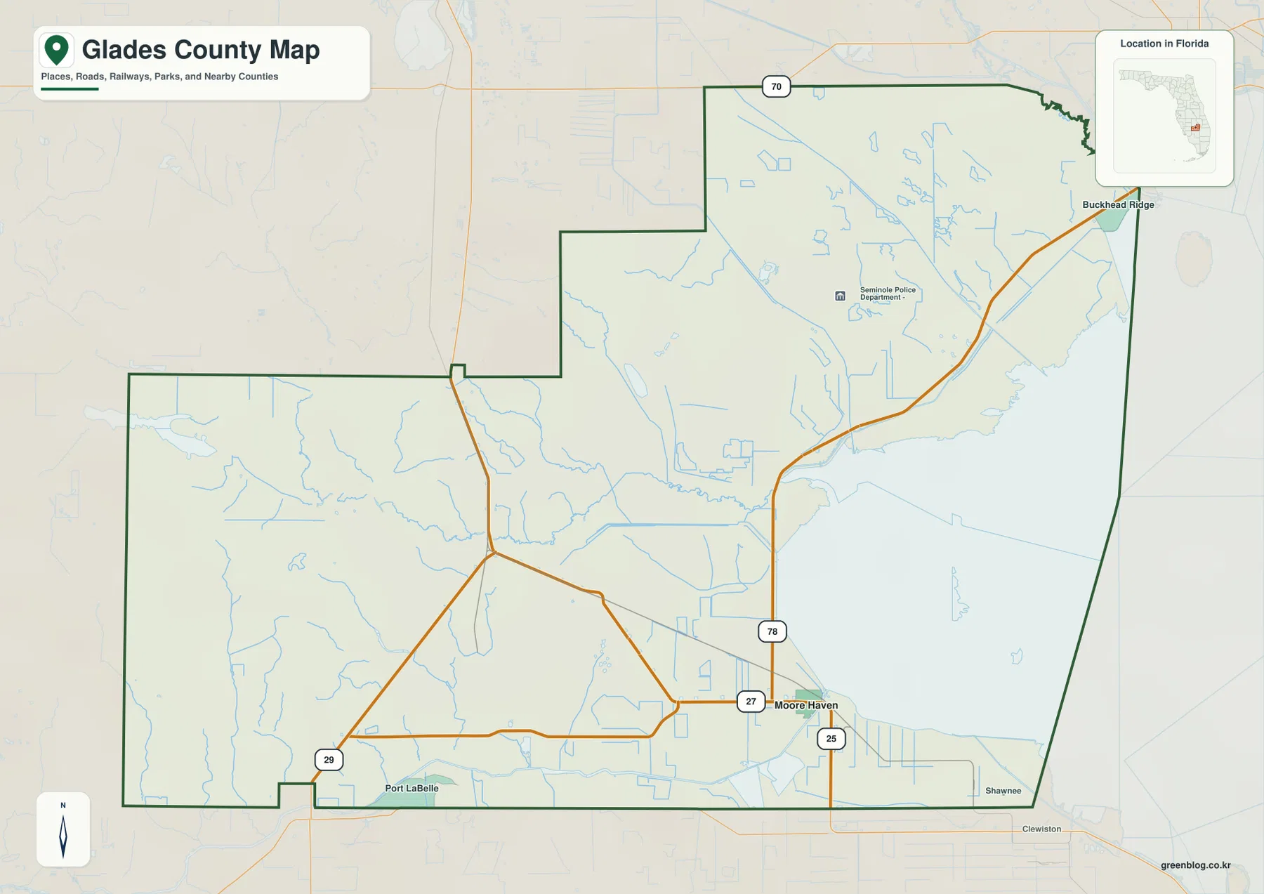
The Glades County Map is easiest to understand by starting at Moore Haven. The county seat sits where U.S. 27 and State Road 78 meet, while the Julian Keen Jr. Lock and Dam (S-77) lies just to the east at the Lake Okeechobee outlet into the C-43 Caloosahatchee channel. Lakeport and Buckhead Ridge occupy different points along the western and northwestern lake rim, and Palmdale, Ortona, Muse, and northern Port LaBelle provide separate inland references. The package includes county, city, and water maps. Download the high-resolution A3 JPG map ZIP from the file box below when you need the full-size versions of all three.
Table of Contents
Moore Haven Combines the County Seat, Highway Junction, and Lake Outlet
Moore Haven appears in the southeastern part of the county where U.S. 27 arrives from the Palmdale side and State Road 78 turns toward the lake-rim communities. The map also shows the SR 25 designation south of the city. Because the government center and several major routes come together here, Moore Haven is the most useful starting point for placing other Glades County communities.
The city’s water setting is equally important. Just east of Moore Haven, the Julian Keen Jr. Lock and Dam—identified as S-77—controls the connection between Lake Okeechobee and the C-43 Caloosahatchee channel. U.S. Army Corps of Engineers material supplied in the package places this structure within the Okeechobee Waterway system. A single Moore Haven reference therefore aligns the county seat, main highway junction, dike passage, and western lake-navigation outlet.
The broad lake can make nearby places look deceptively close. Glades County’s legal boundary crosses portions of Lake Okeechobee, but the shoreline, Rim Canal, Herbert Hoover Dike, and county line do not always coincide. A point across the water may require a long road detour to an authorized dike or bridge crossing, so straight-line distance is a poor guide for actual travel around the lake.
Lakeport and Buckhead Ridge Occupy Different Parts of the Lake Rim
Lakeport lies near Harney Pond, where the lower Fisheating Creek system reaches the northwestern Lake Okeechobee shore. The existing package identifies S-131 as the lake-access lock associated with that area. Buckhead Ridge is farther northeast near the Okeechobee County line and is associated with S-127. Both communities relate to the broad SR 78 corridor, but their correct order from Moore Haven is Lakeport first and Buckhead Ridge farther northeast.
Treating the two places as a single lakefront settlement area hides an important difference. Lakeport is tied to the Fisheating Creek–Harney Pond side of the lake, whereas Buckhead Ridge is a useful reference for the northeastern rim and the county boundary with Okeechobee County. Their lock numbers are different as well, so S-131 at Lakeport and S-127 at Buckhead Ridge should not be interchanged.
South Florida Water Management District navigation notices are the proper source for current operating conditions at these lake-rim structures. A static map can show where a lock belongs, but water level, maintenance, and safety conditions can change whether it is usable on a particular day.
Palmdale Links the Western Road Network with Fisheating Creek
Following U.S. 27 northwest from Moore Haven leads to Palmdale, where State Road 29 turns south toward LaBelle. Palmdale is a small community, but the road junction and its proximity to the Fisheating Creek access area make it one of the strongest orientation points in the western half of the county. Once U.S. 27 and SR 29 are located, the broad rural area west of Lake Okeechobee becomes much easier to organize.
Fisheating Creek looks completely different from the straight canal network around it. The creek winds through broad wetlands before reaching Lake Okeechobee near Lakeport. South Florida Water Management District material in the package treats the creek as a major natural tributary, and the existing county material describes roughly 52 miles of free-flowing water through the wetland landscape. Palmdale anchors the inland access side, while Lakeport helps locate the receiving end at the lake.
Muse lies farther southwest in a rural setting, and northern Port LaBelle reaches across the Hendry County line into the southern part of Glades County. These examples show why a postal place name alone is not enough for parcel or service questions. The county line should be checked whenever a planned community or mailing address extends across jurisdictions.
The City Map Highlights Moore Haven as the Only Major Ranked City
The simplified city map removes nearly all secondary settlement labels and highlights Moore Haven alone. Its CITY INDEX shows 2,131 for Moore Haven, making the municipal pattern unusually simple compared with many Florida counties. Buckhead Ridge, Lakeport, Palmdale, Ortona, and Muse remain important geographic communities without appearing as equivalent ranked cities.
The official Glades County communities guide supplied in the package reinforces that distinction. Moore Haven serves as the incorporated county-seat center, while the other named places are useful for local orientation, lake access, roads, or rural districts. A large label on a general map should therefore not be treated automatically as proof of municipal status.
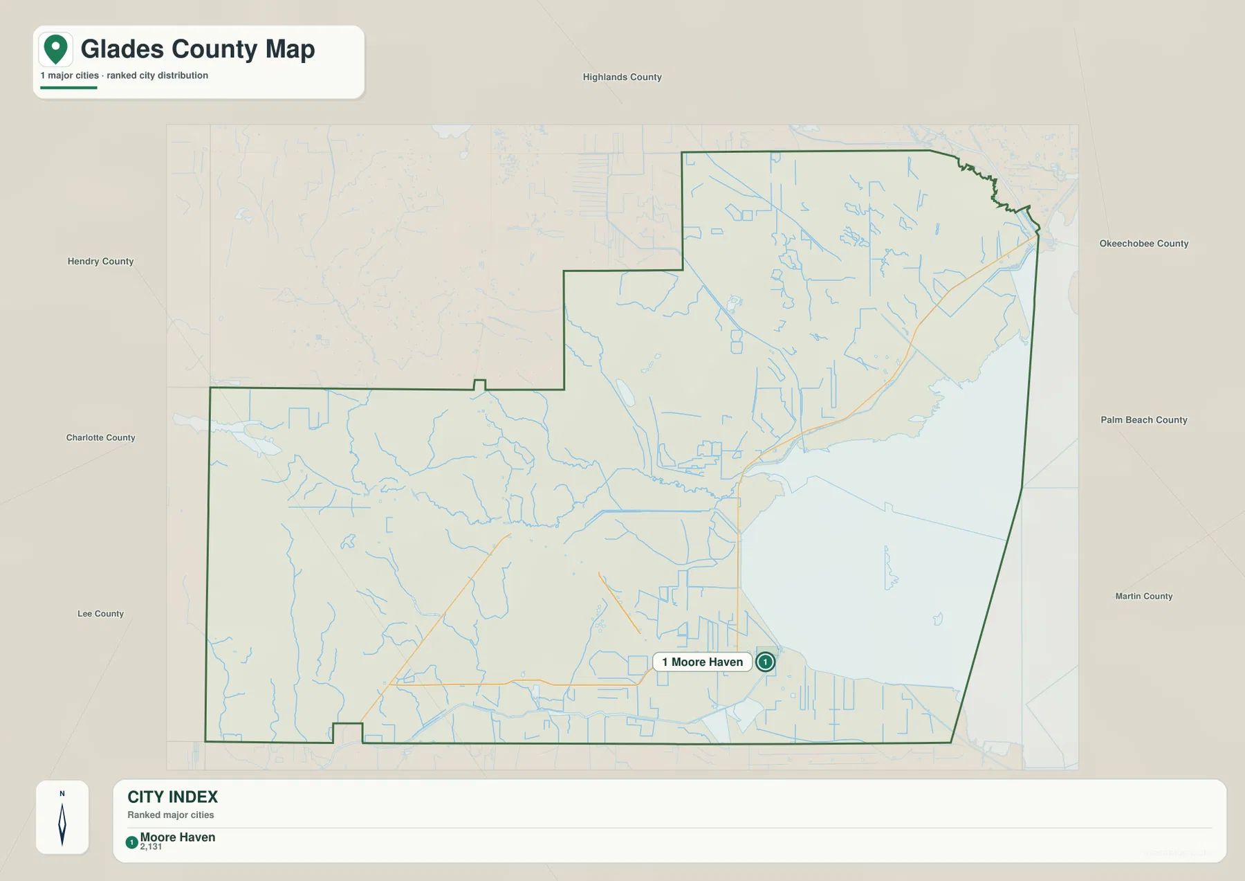
The surrounding county labels also show how large Glades County is beyond Moore Haven. Okeechobee County is close to the northeastern lake side, while legal water boundaries bring Palm Beach and Martin counties into the broader Lake Okeechobee context. Hendry, Lee, and Charlotte lie to the south and west, and Highlands County borders the north. The county therefore cannot be understood as a compact Moore Haven urban area.
Fisheating Creek and Harney Pond Canal Stand Out on the Water Map
The terrain-and-water map gives Fisheating Creek a prominent curving line across the central part of the county. Harney Pond Canal appears farther north as a straighter engineered waterway. The contrast is useful: Fisheating Creek follows a natural meandering course, whereas the canal cuts through the landscape with a more regular shape. Seeing them together makes it easier to distinguish natural drainage from managed water infrastructure.
Lake Okeechobee dominates the eastern side, with labels such as Moonshine Bay, Eagle Bay, and Coot Bay. South of Moore Haven the map adds Lake Hicpochee and an Industrial Waste Pond, while the southwestern interior includes Jack’s Branch, Bee Branch, and Pollywog Creek. These smaller features rarely define travel routes, but they show how thoroughly the county’s low rural land is divided by streams, canals, ponds, and wet depressions.
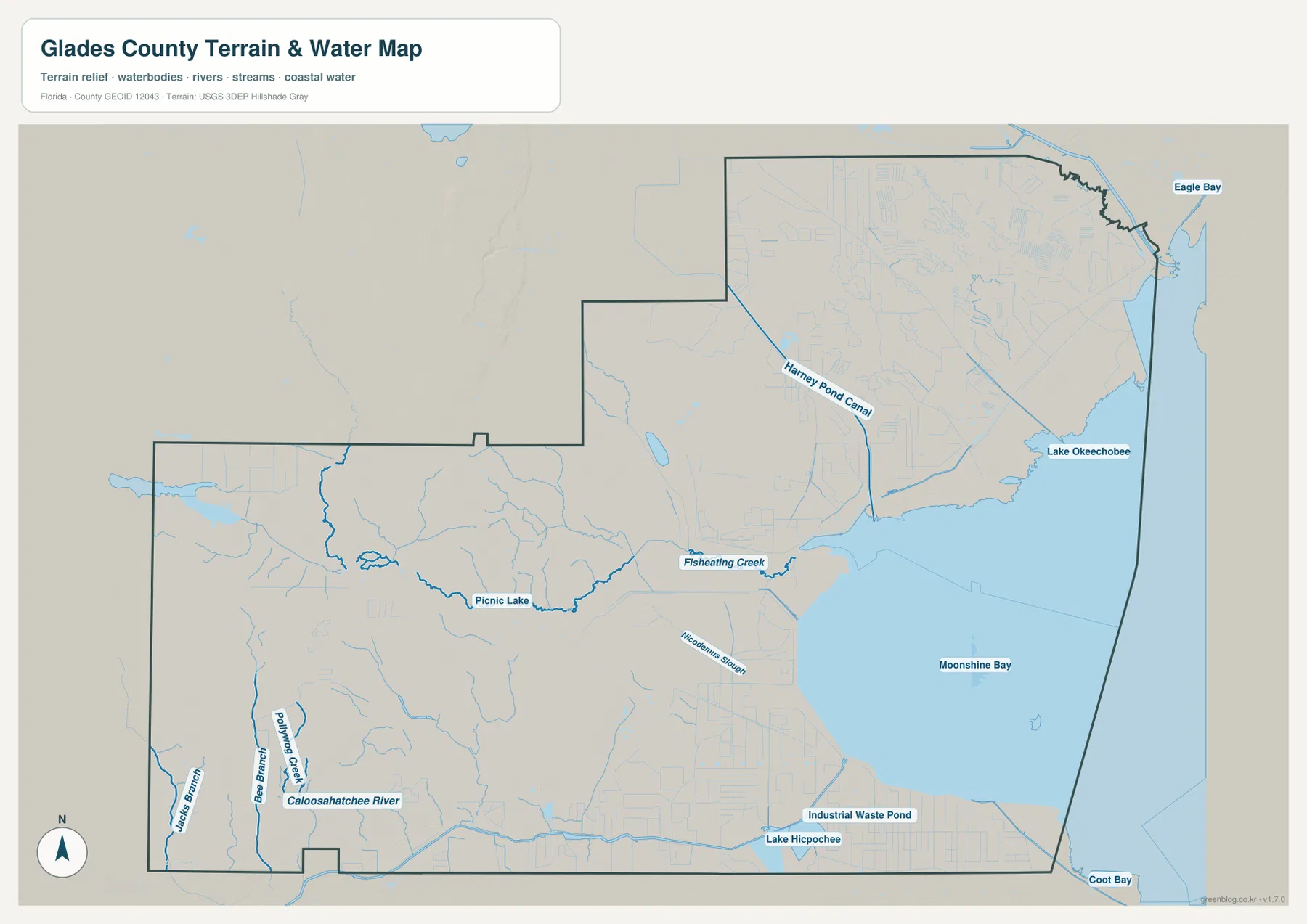
C-43 Connects Moore Haven and Ortona Through a Managed Waterway
The C-43 Caloosahatchee channel west of Moore Haven is fundamentally different from Fisheating Creek. It is a managed navigation and water-control route linked to the Okeechobee Waterway. The package’s SFWMD and U.S. Army Corps of Engineers sources identify S-77 at Moore Haven and S-79 at Ortona as important control structures along this corridor.
Ortona belongs to the same waterway setting but not to a continuous urban strip with Moore Haven. Broad rural land, canals, and wetlands lie between the two communities, while road crossings occur only at specific bridges and structures. A straight canal line on the map does not mean a parallel public road follows every part of the bank.
The larger Okeechobee Waterway links the Atlantic side near Stuart with the Gulf side near Fort Myers. Within Glades County, S-77 and S-79 are particularly useful fixed references, but a fixed location does not guarantee current passage. Navigation notices and Corps operating information should be checked for water levels, maintenance, and temporary restrictions.
Brighton Seminole Reservation Is a Separate Land Jurisdiction
A large part of the northern interior is associated with the Brighton Seminole Reservation. It is not an incorporated city or an ordinary county subdivision, and roads visible on a map do not automatically establish unrestricted public access. Reservation boundaries and access rules need to be treated separately from the surrounding county road network.
This matters because Lakeport and Buckhead Ridge are also nearby northern references. The three labels can appear close at county scale, yet they represent different geographic and administrative concepts: Moore Haven is the incorporated city, Lakeport and Buckhead Ridge are unincorporated communities, and Brighton is reservation land with separate jurisdiction. Keeping those categories distinct prevents misleading descriptions of the northern county.
Choose the Map Based on Whether You Need Roads, Cities, or Water
The county map is the best single choice for Moore Haven, Palmdale, Buckhead Ridge, U.S. 27, SR 29, and SR 78. The city map is cleaner when the main question is Moore Haven’s municipal role. The water map is more useful for Fisheating Creek, Harney Pond Canal, Lake Okeechobee, the Caloosahatchee channel, and the smaller western tributaries.
No separate elevation map is included in this package, so exact elevations or contour lines should not be inferred from these files. The water map is not a flood-zone, parcel-boundary, or marine-navigation chart, and the road map does not show live construction, lock operations, or dike closures. Current official data should be used for navigation, flood, property, or travel decisions.
For printing or larger documents, use the ZIP below rather than relying only on the web previews. The archive contains three A3 high-resolution JPG files corresponding to the county, city, and water maps shown on this page. Each JPG can be used separately for a classroom handout, regional overview, trip-planning note, or presentation.
Frequently Asked Questions
Why is Moore Haven such an important Lake Okeechobee reference?
Moore Haven combines the county seat, the U.S. 27–SR 78 road junction, and the nearby S-77 Julian Keen Jr. Lock and Dam. That single area connects county government, highway orientation, the lake dike, and the C-43 navigation outlet.
How can Lakeport and Buckhead Ridge be distinguished on the map?
Lakeport is near Harney Pond where Fisheating Creek reaches the lake and is associated with S-131. Buckhead Ridge is farther northeast near the Okeechobee County line and is associated with S-127. They share the broader SR 78 lake-rim corridor but occupy different positions and use different lock references.
Are Fisheating Creek and C-43 the same kind of waterway?
No. Fisheating Creek is a natural, winding tributary that crosses western wetlands before reaching Lake Okeechobee. C-43 is a managed Caloosahatchee navigation and water-control channel extending west from Moore Haven toward Ortona.
Map File Information
Download one ZIP containing the three A3 high-resolution JPG files that match the county map, city map, and water map shown on this page.
- Included Files: County map, city map, and water map JPGs
- File Type: ZIP containing 3 JPG files
Related Maps
- Arcadia Roads and Peace River | DeSoto County Florida Map
- Baker County Florida Map
- Blountstown, SR 20, and the Apalachicola River | Calhoun County Florida Map
Sources
- U.S. Census Bureau QuickFacts — Glades County — population, land area, and density reference
- Glades County official communities guide — Moore Haven, Lakeport, Buckhead Ridge, Palmdale, Ortona, and Muse
- Florida Department of Transportation — County General Highway Maps — U.S. 27, SR 29, SR 78, and SR 80
- South Florida Water Management District — Caloosahatchee River Watershed Protection Plan — C-43 and regional water-system reference
- SFWMD Navigation Notices — current lake-rim lock and navigation information
- U.S. Army Corps of Engineers — Julian Keen Jr. Lock and Dam — Moore Haven S-77 reference
Green Map creates custom-edited map images using open geographic data sources such as geoBoundaries, Natural Earth, OpenStreetMap, and government open data. These maps are edited visual materials, not raw data files, and are provided for education, documents, presentations, and graphic reference.