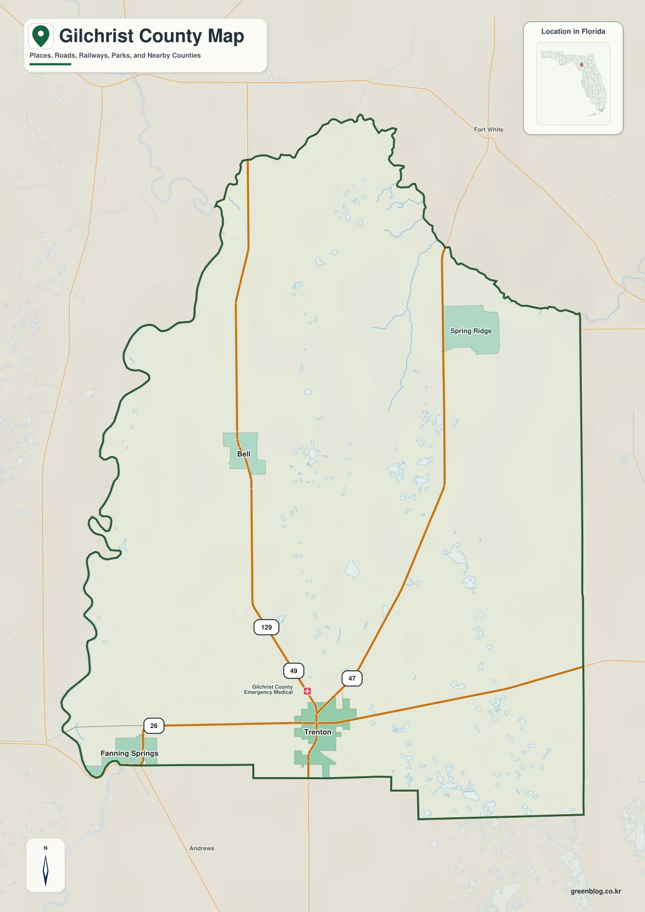
The Gilchrist County Map becomes much easier to read once Trenton’s U.S. 129–SR 26 intersection is used as the starting point. U.S. 129 runs north to Bell, SR 26 heads west toward Fanning Springs and the Suwannee River, and the county’s northern edge follows the Santa Fe River. The Suwannee then turns south along much of the western boundary, giving the county two major river edges in addition to its straighter eastern and southern lines. The package contains a county map, city map, and water map. Download the high-resolution A3 JPG map ZIP from the file box below when you need the full-size versions of all three.
Table of Contents
Trenton’s U.S. 129–SR 26 Junction Is the Main Inland Reference
Trenton appears in the south-central part of the county where U.S. 129 meets State Road 26. That crossing serves both as an administrative center and as the simplest directional anchor. U.S. 129 leads north toward Bell, while SR 26 runs west toward Fanning Springs and east toward Newberry and the Gainesville side of Alachua County.
State Road 47 and County Road 340 provide secondary references for the northeast and northern rural areas. SR 47 angles northeast from the Trenton side toward Spring Ridge and a Santa Fe River crossing, while CR 340 links roads north of Bell with river approaches farther east. Reading these roads after U.S. 129 and SR 26 keeps the county layout clear instead of turning every numbered route into an equal visual priority.
Fanning Springs is shown near the southwest edge beside the Suwannee River. Its municipal area extends across the Gilchrist–Levy county line, so a label that appears to overlap the boundary is not necessarily misplaced. SR 26 reaches the U.S. 19/U.S. 27 Alternate/U.S. 98 corridor there, making Fanning Springs an important gateway from the small inland county to a larger north-south highway system.
The City Map Highlights Trenton and Bell as the Main Ranked Centers
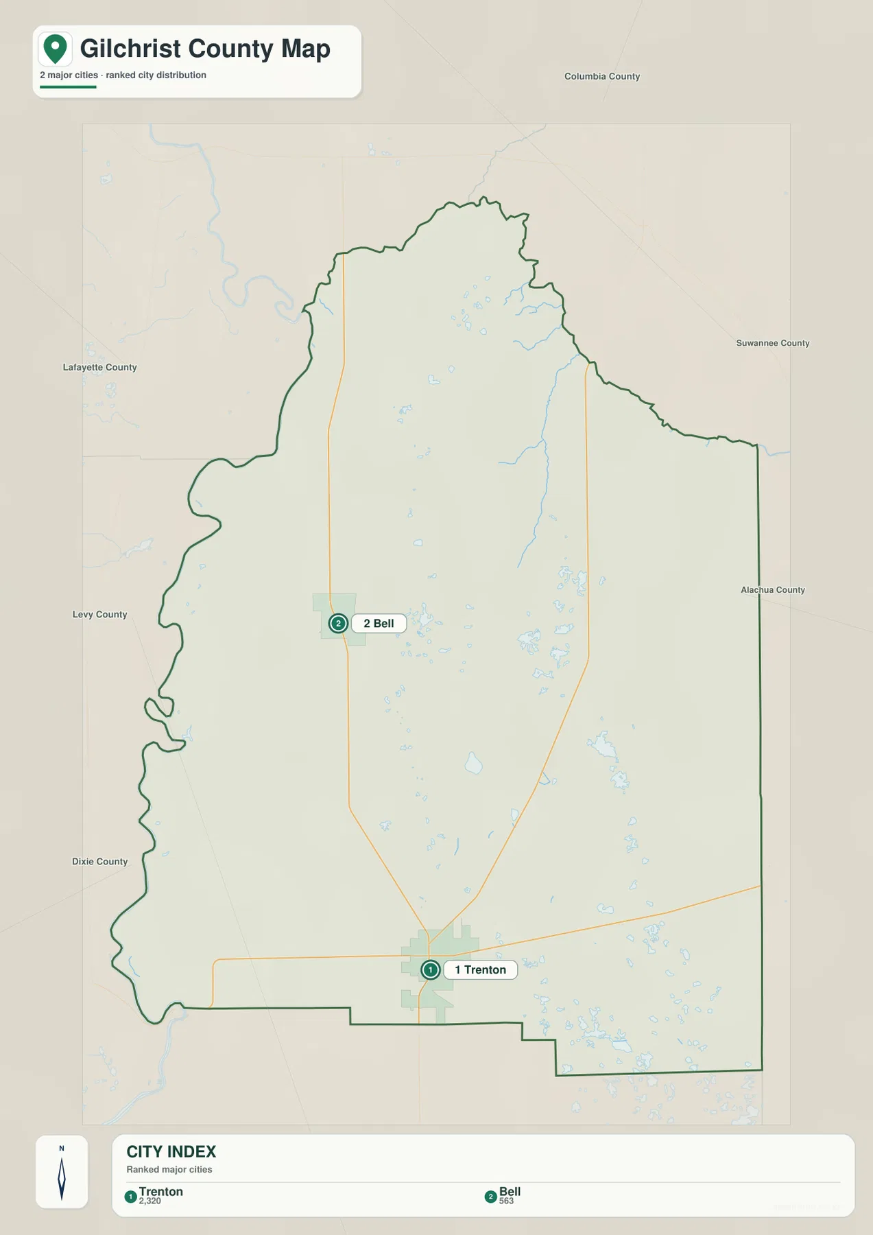
The simplified city map removes much of the road detail and highlights Trenton and Bell. Its CITY INDEX lists Trenton at 2,320 and Bell at 563, showing the large difference in map-index size between the county seat and the northern incorporated center. Trenton anchors the southern administrative core, while Bell provides the clearest municipal reference on the northern U.S. 129 corridor.
Surrounding county labels add useful context. Columbia and Suwannee counties lie to the north, Alachua to the east, Levy to the south, and Dixie and Lafayette to the west and northwest. Trenton is therefore closer to the Alachua–Levy side of the county, while Bell sits much nearer the northern river boundary and the roads leading toward Suwannee and Columbia counties.
Fanning Springs is an incorporated municipality but is not included among the two ranked major-city markers on this simplified graphic. Its geographic role is still important because it straddles the county line beside the Suwannee River. For administrative detail, the general county map and official municipal records provide more context than the two-city ranking alone.
The Santa Fe and Suwannee Rivers Create the County’s Irregular Edges
The county’s most recognizable boundaries are formed by water rather than survey lines. The Santa Fe River runs west along much of the northern side and meets the Suwannee near the northwest corner. From that confluence, the Suwannee bends south along the western edge. These two rivers give Gilchrist County a curved north-and-west outline that contrasts sharply with the straighter Alachua and Levy county lines.
The neighboring jurisdiction across the water changes by segment. Columbia, Suwannee, and Lafayette county areas lie beyond parts of the Santa Fe, while Lafayette and Dixie county areas appear across the Suwannee. A location can look close across a river bend yet require a much longer road route when no bridge is nearby, so river crossings matter more than straight-line distance along these borders.
This difference between curved river boundaries and straight administrative lines is one of the easiest ways to remember the county’s overall shape. It also explains why roads approaching the north and west edges do not continue directly across every point where another road appears nearby on the opposite bank.
Gilchrist Blue Springs Belongs to the Santa Fe River Landscape
Ruth B. Kirby Gilchrist Blue Springs State Park is not in downtown Trenton. It sits in the northern part of the county beside the Santa Fe River. Florida State Parks lists Gilchrist Blue, Little Blue, Naked, Kiefer, and Johnson springs on the property, with the main spring feeding a short run before reaching the river.
Karst groundwater, spring runs, and floodplain conditions are more useful for understanding this landscape than large elevation changes. The Florida DEP management material supplied with the package describes a setting where the Floridan aquifer and the Santa Fe River interact closely. When river levels rise, darker river water can enter the normally clear spring run, showing that the springs and the river are parts of one changing water system.
Hart Springs and Otter Springs add two county-operated destinations along the western Suwannee side. Their mailing addresses use Bell or Trenton names, but that does not place them inside those municipal centers. For rural spring destinations, the official street address, county-road approach, and river location are more reliable than the postal city name alone.
Cow Creek and Small Lakes Fill in the Interior Water Picture
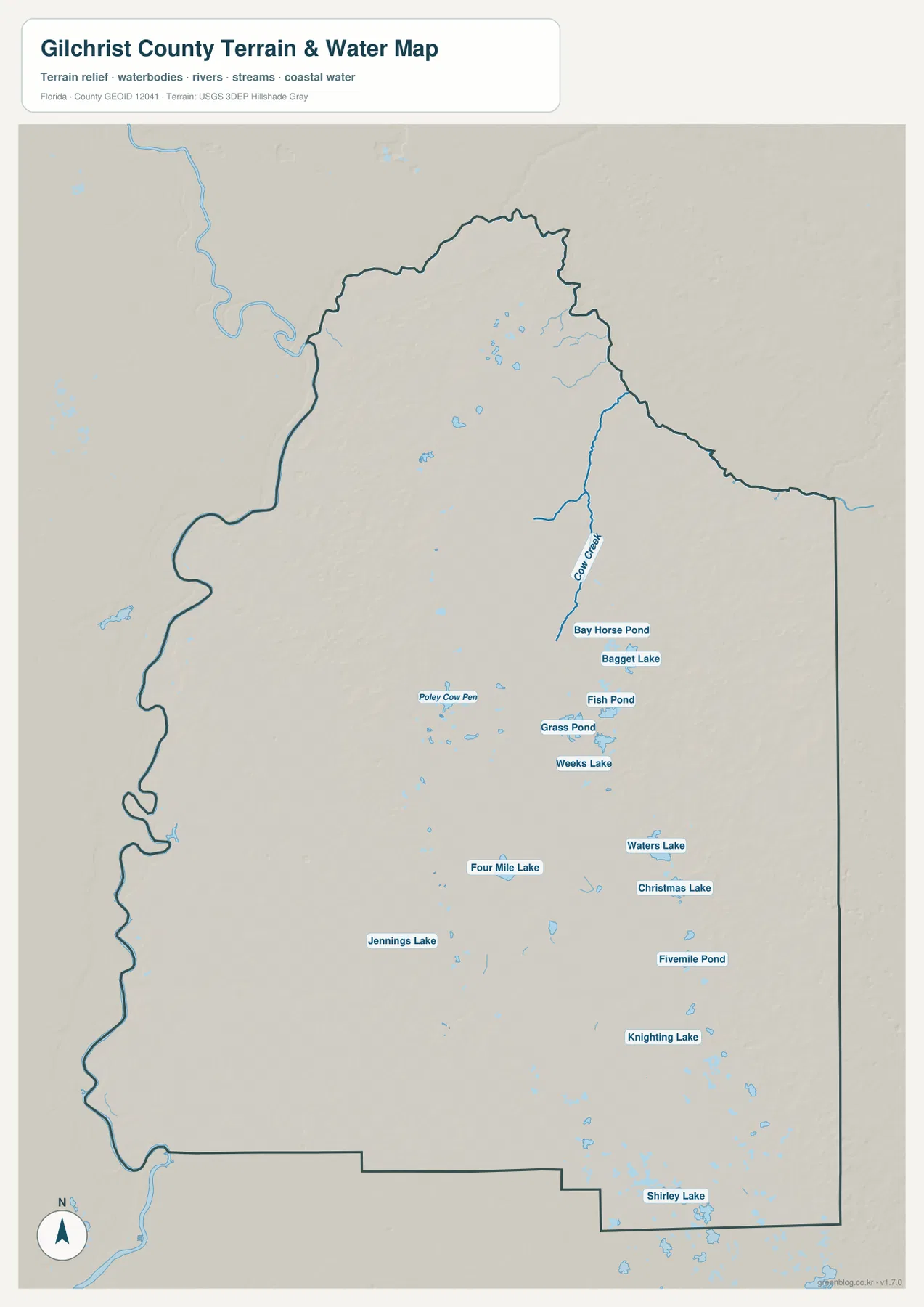
The terrain-and-water map adds many small features that are difficult to notice on the general road map. Cow Creek runs through the northeastern interior, with Bay Horse Pond and Bagget Lake nearby. Fish Pond, Grass Pond, and Weeks Lake appear in the same broad part of the county, showing that the northeast contains many wet depressions and small water bodies in addition to the large boundary rivers.
Farther south and west, the map labels Four Mile Lake, Jennings Lake, Waters Lake, Christmas Lake, Fivemile Pond, Knighting Lake, and Shirley Lake. These features do not define county boundaries, but they make the rural interior easier to read and show why a highway-only view can understate the amount of water and wet ground scattered across Gilchrist County.
A Young Florida County with a Growing Rural Population
Florida Memory material supplied with the package explains that Gilchrist County was created on December 4, 1925 from western Alachua County. It became Florida’s 67th and most recently established county, and its name honors Albert W. Gilchrist, who served as governor from 1909 to 1913. The present eastern line with Alachua County is therefore both a modern administrative border and a reminder of that separation.
The Census figures included in the package list 17,864 residents in 2020, 349.70 square miles of land, and a density of 51.1 people per square mile. The July 1, 2025 estimate is 20,488. Those numbers help explain why the map has widely spaced settlement labels even as the population has grown: much of the county remains rural rather than forming one continuous urban area around Trenton.
Use the Map That Matches the Question
Choose the county map when you need Trenton, Bell, Fanning Springs, U.S. 129, SR 26, SR 47, and the county boundaries in one view. The city map is cleaner for comparing Trenton and Bell, while the water map is better for Cow Creek, ponds, and small interior lakes. The three graphics describe the same county but emphasize different relationships.
No separate elevation map is included in this package, so exact elevations or contour lines should not be inferred from these files. The water map is not a flood-zone, parcel-boundary, or navigation product, and the road map does not provide live traffic or construction conditions. Use current official records for property, flood, emergency, or travel decisions.
For printing or larger documents, use the ZIP below rather than relying only on the web previews. The archive contains three A3 high-resolution JPG files corresponding to the county, city, and water maps shown on this page. Each file can be used separately for a classroom handout, local-reference document, presentation, or trip-planning note.
Frequently Asked Questions
How do the Santa Fe and Suwannee rivers define the county edges?
The Santa Fe River follows most of the northern boundary and meets the Suwannee near the northwest corner. The Suwannee then turns south along much of the western boundary, creating the county’s curved north-and-west outline.
Is Gilchrist Blue Springs in downtown Trenton?
No. Ruth B. Kirby Gilchrist Blue Springs State Park is in the northern part of the county beside the Santa Fe River. Its relationship to the river and northern county roads is more useful for locating it than the Trenton name alone.
Why does Fanning Springs appear on the county line?
The municipality extends into both Gilchrist and Levy counties. Its southwest position beside the Suwannee River means the city label can legitimately appear on or near the county boundary.
Map File Information
Download one ZIP containing the three A3 high-resolution JPG files that match the county map, city map, and water map shown on this page.
- Included Files: County map, city map, and water map JPGs
- File Type: ZIP containing 3 JPG files
Related Maps
- Arcadia Roads and Peace River | DeSoto County Florida Map
- Baker County Florida Map
- Blountstown, SR 20, and the Apalachicola River | Calhoun County Florida Map
Sources
- Gilchrist County Board of County Commissioners — county government and local overview
- U.S. Census Bureau QuickFacts — Gilchrist County — population, land area, and density reference
- Florida Department of Transportation — County General Highway Maps — U.S. 129, SR 26, SR 47, and road reference
- Florida State Parks — Ruth B. Kirby Gilchrist Blue Springs — Santa Fe River and spring reference
- Florida Memory — Gilchrist County History — 1925 county creation reference
- Gilchrist County Parks and Recreation — Hart Springs and Otter Springs reference
Green Map creates custom-edited map images using open geographic data sources such as geoBoundaries, Natural Earth, OpenStreetMap, and government open data. These maps are edited visual materials, not raw data files, and are provided for education, documents, presentations, and graphic reference.