You can download four high-resolution A3 JPG maps of Spalding County from this page in one ZIP: a county reference map, a ranked city map, a terrain-and-water map, and an elevation map. Griffin is the main reference point, with major roads radiating from the central city and smaller labeled communities around it. Beyond that urban core, a dense network of creeks lies between the Flint and Towaliga river systems, and the elevation map shows a range of about 177 to 311 meters. The WEBP images in the article are intended for quick on-screen viewing, while the JPG files are better suited to printing or placing in reports. These county-scale maps are not substitutes for parcel surveys, turn-by-turn navigation, flood studies, or engineering-grade elevation data.
Table of Contents
Griffin anchors the county while major routes fan outward
The general county map makes Griffin the obvious reference point. Road lines and local labels are most concentrated around the city, with Experiment just to the northwest and East Griffin immediately to the east. Sunny Side appears farther north, while Orchard Hill sits near the southeastern edge. The result is not an even scatter of towns across the county. Instead, settlement labels cluster around Griffin and thin out toward the western and southern margins, where streams and rural roads become more visually prominent.
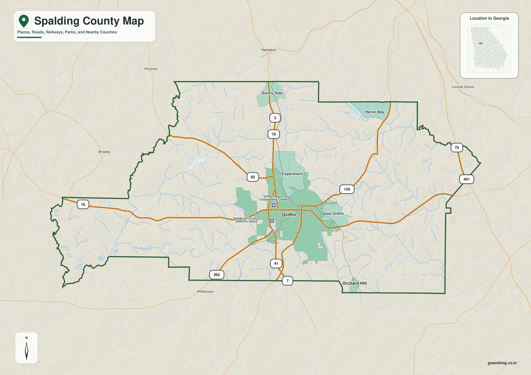
Several labeled highways help explain that pattern. Route 16 crosses the county from west to east through Griffin. The north-south corridor is marked by route numbers 3 and 19 north of the city and 41 and 7 to the south. Route 92 approaches from the west, 362 comes in from the southwest, and 155 heads northeast. At the far northeastern side, 75 and 401 markers appear near the edge of the county. The map is therefore most useful for understanding how the county’s main corridors relate to Griffin, rather than for choosing a specific driving route.
Within the Griffin area, the map also labels places such as Griffin Region College and Career Academy and the Spalding County Sheriff’s Office. Those landmarks reinforce the concentration of civic and institutional activity near the central city. Railroad lines are also included in the reference-map styling, which fits Griffin’s long-standing role as a transportation center, but the map does not provide schedules, ownership, or operational rail details. For that level of information, a dedicated transportation source would be necessary.
A two-city ranking puts Griffin far ahead of Orchard Hill
The city map strips away much of the road detail and emphasizes only the ranked major cities supplied with the dataset. Its City Index lists Griffin at 23,761 and Orchard Hill at 152, placing them first and second respectively. Those values should be read as the population figures shown on the map rather than as a replacement for the latest Census release. Their main purpose here is to show the scale difference between the county’s dominant city and its much smaller second-ranked municipality.
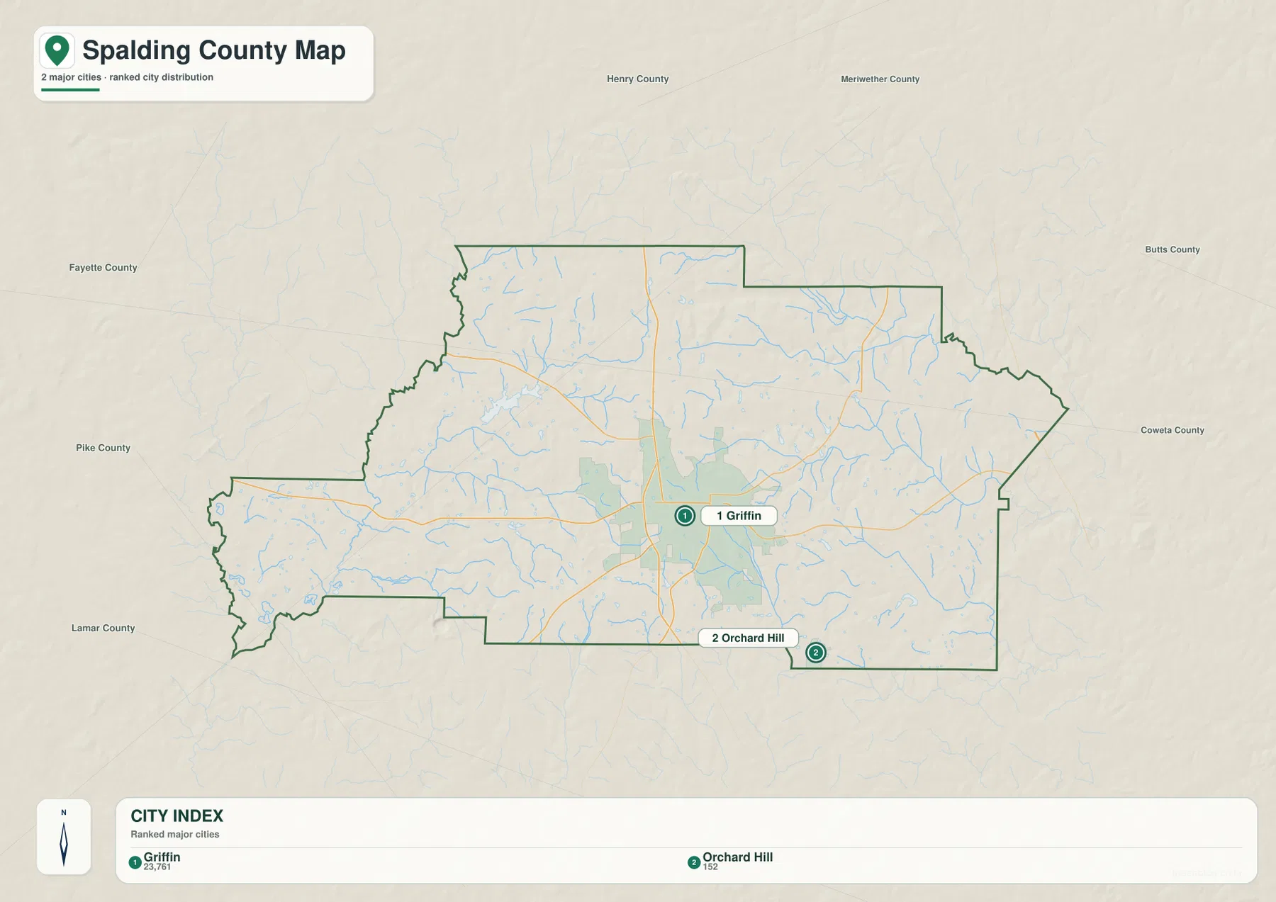
This simplified view is especially helpful because the reference map contains other named places that do not appear in the City Index. Sunny Side, Experiment, and East Griffin are useful geographic labels on the county map, but the ranked city graphic focuses on Griffin and Orchard Hill. For a presentation about the county’s principal urban center, the city map is clearer. For a discussion of local settlement patterns or road connections, the fuller county map provides the context that the ranking intentionally removes.
The contrast also helps explain why Griffin should be used as the first orientation point when reading the other maps. Once its central position is established, readers can track Route 16 east and west, follow the north-south highway corridor, then compare the city center with the surrounding creeks and ridges. Orchard Hill, by contrast, is a useful marker near the southeastern boundary but does not carry the same concentration of roads and labels.
Flint River and Towaliga River frame a dense creek-and-reservoir network
The terrain-and-water map changes the county’s visual emphasis completely. The Flint River runs along the western to southwestern side, while the Towaliga River appears at the eastern edge. Between them, the county is crossed by smaller drainage lines such as Heads Creek, Shoal Creek, Troublesome Creek, Cabin Creek, and Flat Creek. Instead of one dominant river flowing through the center, Spalding County looks like a network of short creeks draining away from interior ridges toward larger river systems on opposite sides.
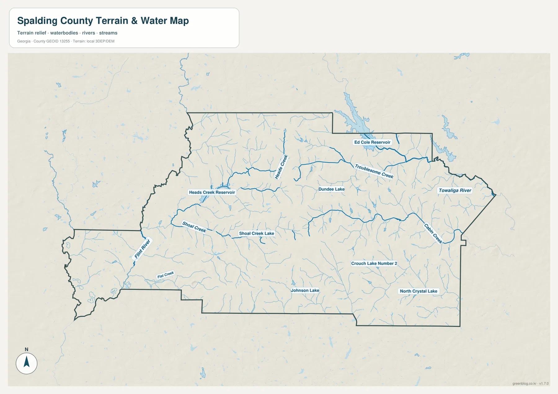
Named water bodies are scattered across several parts of the county. Heads Creek Reservoir lies toward the northwest, Ed Cole Reservoir is near the north-central to northeastern side, and Dundee Lake and Shoal Creek Lake sit closer to the interior. Johnson Lake and North Crystal Lake appear farther south, with Crouch Lake Number 2 to the southeast. The map does not indicate public access, ownership, boating rules, or recreational status for these water bodies; it is designed to show their geographic position and relationship to the surrounding drainage network.
Following the water features also reveals why a county map centered on roads can feel very different from the same county viewed through hydrography. Around Griffin, highways and urban labels dominate. Away from that core, the water map exposes many narrow valleys and tributaries that are nearly invisible on the city map. For environmental orientation, watershed discussion, or a lesson on how local streams connect to larger rivers, this water-focused version is the more informative starting point.
Elevation rises to 311 meters on interior ridges and falls along drainage corridors
The elevation map reports an actual county range of roughly 177 to 311 meters, with a mean of about 248 meters. That range is modest compared with a mountain county, yet the shaded relief shows a surprisingly textured surface. Brown and tan ridges are concentrated through the interior, especially across the central, south-central, and north-central parts of Spalding County. Greener lower ground follows many of the creek valleys and becomes more apparent toward the Flint River side in the west and the Towaliga and Cabin Creek drainage in the east.
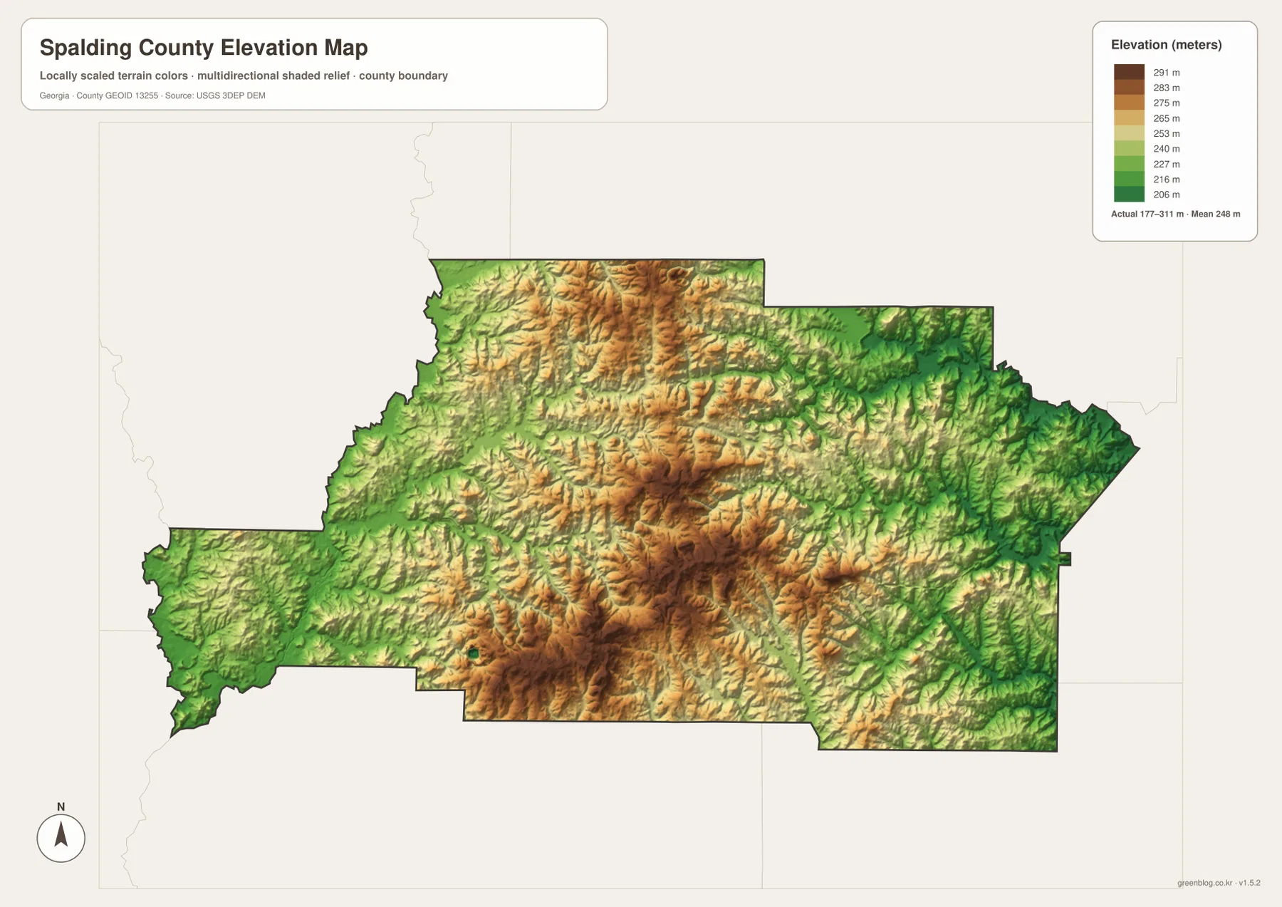
The local color scale is important to interpret correctly. A dark brown patch is high relative to other places in Spalding County, but it is not a high mountain. The highest mapped terrain is a little above 300 meters. When the elevation map is placed beside the water map, the relationship becomes clearer: creek lines repeatedly occupy lower green corridors, while the tan and brown ridges between them separate one small drainage from another.
This makes the elevation layer useful for county-scale terrain comparison rather than site-specific measurement. It can show why streams bend through certain low areas, where the broad interior uplands lie, and how the county transitions toward the larger river valleys. It should not be used to establish the exact elevation of a parcel, a building pad, a road crossing, or a flood-control structure.
The maps tell a different story depending on whether you follow roads or water
On the reference map, Spalding County looks highly centralized because Griffin sits where several important roads meet. On the water map, the same county looks divided by many creek valleys between two larger river systems. The elevation map explains why both impressions are true. Roads cross the interior ridges to connect Griffin with the county edges, while streams occupy lower corridors and drain away toward the Flint or Towaliga systems. Reading the layers together turns a simple county outline into a more complete picture of how settlement, transportation, water, and relief are arranged.
A reader interested in access and settlement can begin with Griffin and Route 16, then use the other labeled highways to understand the county’s major directions. A water-focused project can ignore most of that road detail and instead trace Heads Creek, Shoal Creek, Troublesome Creek, and the named reservoirs. For terrain, the 177–311 meter elevation layer is the clearest way to compare the higher interior with lower creek and river valleys. Each map is therefore useful for a different question without requiring the reader to change the county extent or orientation.
This sequence works well for classroom or report use because it moves from familiar human features to the underlying natural landscape. Start with Griffin and the main corridors, then locate the larger rivers and reservoirs, and finally compare those water features with the shaded relief. If the task involves property ownership, flood risk, exact road conditions, or engineering measurements, however, a specialized and current official dataset should replace these general reference maps.
Use the web previews for orientation and the A3 JPG set for detailed viewing
The WEBP images embedded above are optimized for browsing and quick comparison. The downloadable ZIP keeps the same four themes as high-resolution A3 JPG files. The county reference map is the best first choice for roads and named places, while the city map gives a cleaner Griffin-versus-Orchard-Hill comparison. The water map is more useful for the Flint River, Towaliga River, creeks, reservoirs, and lakes, and the elevation map is the clearest option for comparing interior ridges with lower drainage corridors.
Frequently Asked Questions
Why does the city map rank only Griffin and Orchard Hill?
The supplied ranked-city map contains Griffin and Orchard Hill in its City Index, with values of 23,761 and 152. Other labels such as Sunny Side, Experiment, and East Griffin appear on the fuller county reference map but are not part of that two-city ranking.
Which major rivers appear on opposite sides of Spalding County?
The Flint River is shown along the western to southwestern side, while the Towaliga River appears at the eastern edge. A network of smaller creeks and reservoirs fills the interior between those larger river systems.
How much elevation change is shown within the county?
The elevation map reports an actual range of about 177 to 311 meters and a mean near 248 meters. Interior ridges are generally higher, while the major river and creek corridors occupy lower ground.
Sources and reference links
These links provide additional county background and official resources for boundaries, hydrography, and elevation.
- U.S. Census Bureau QuickFacts for Spalding County
- New Georgia Encyclopedia: Spalding County
- U.S. Census Bureau TIGER/Line boundary data
- USGS National Hydrography
- USGS 3D Elevation Program
Map File Information
The ZIP contains four high-resolution A3 JPG maps of Spalding County: county reference, city distribution, terrain and water, and elevation.
- Included Files: County map · City map · Water map · Elevation map
- File Type: One ZIP containing four high-resolution A3 JPG files
Related Maps
Green Map creates custom-edited map images using open geographic data sources such as geoBoundaries, Natural Earth, OpenStreetMap, and government open data. These maps are edited visual materials, not raw data files, and are provided for education, documents, presentations, and graphic reference.