Rabun County sits in the mountainous northeastern corner of Georgia, where Clayton, a chain of smaller towns, large reservoirs, and steep ridges fit into a relatively compact county. This page brings together four complementary views of the same place, and you can download one ZIP containing four high-resolution A3 JPG maps for printing or offline reference. The maps make it possible to move from the road pattern around Clayton to the town sequence toward Dillard and Sky Valley, then to Lake Burton, Lake Rabun, the Tallulah River, and finally the strong elevation contrast between valley floors and high ridges.
Table of Contents
Clayton at the Center of Rabun County’s Road Network
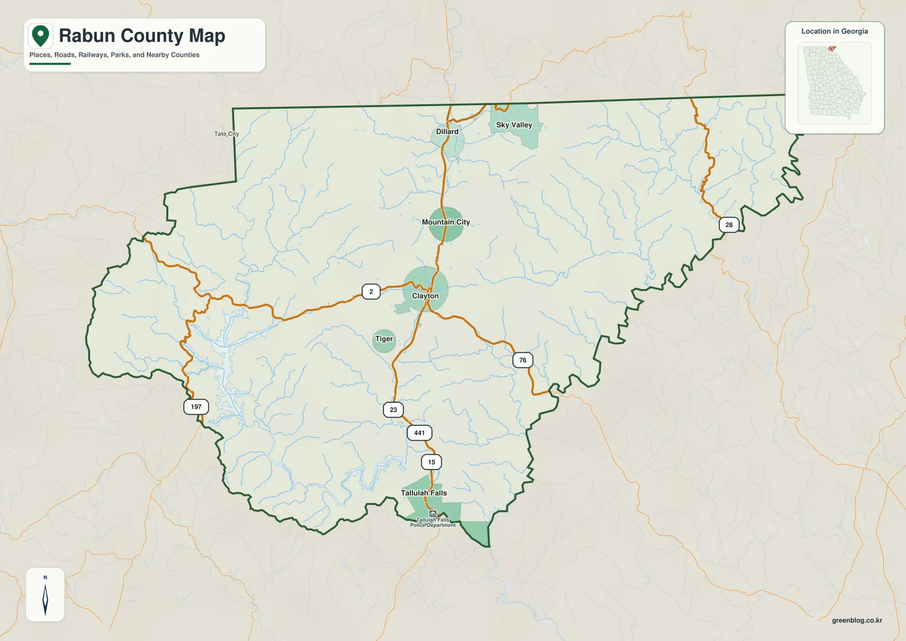
The county reference map makes Clayton the easiest place to use as an orientation point. Clayton is the county seat, and routes 441, 23, and 15 share the main north-south line through the center of the county. Route 2 approaches from the west while 76 continues east of Clayton, creating a clear cross-county connection. Route 197 appears in the southwest and 28 reaches the eastern side. Because the county boundary is irregular, especially toward the east and along the north, the road pattern is more useful than a simple rectangular grid for understanding how places relate to one another.
A north-south string of towns instead of an even spread
From Clayton, Mountain City and Dillard continue north along the main corridor, while Sky Valley sits farther to the northeast. Tiger lies just south of Clayton, and Tallulah Falls is near the southern edge. That arrangement gives the populated places on the map a strong north-south emphasis. The broad eastern part of the county contains many streams but far fewer labeled towns, so the reference map quickly separates the more settled central corridor from the rugged eastern terrain. The western side also includes road and water features, but the most recognizable town sequence remains close to the central highway line.
Five Major Towns from Clayton to the North Carolina Side
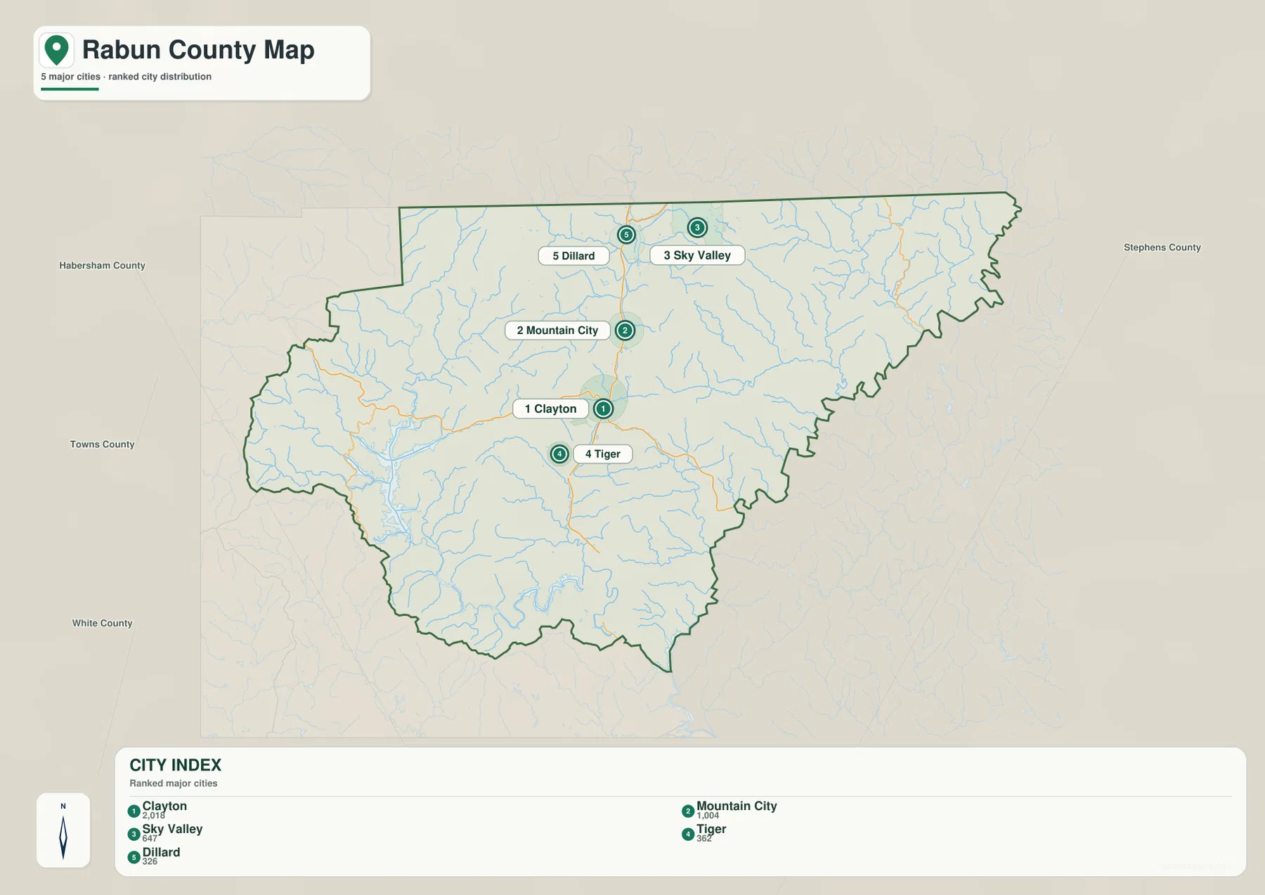
The city map strips away much of the road detail and focuses on five ranked places. Clayton is marked first, Mountain City second, Sky Valley third, Tiger fourth, and Dillard fifth. The ranking is less important than the pattern it reveals: Clayton and Tiger form a central pair, Mountain City and Dillard continue north, and Sky Valley shifts east of the main line. For readers who only need to understand where the named towns sit inside the county, this map is faster to read than the more detailed road map.
Neighboring counties help place Rabun County in northeast Georgia
The city map also labels Habersham County, Towns County, White County, and Stephens County outside the Rabun boundary. Those names provide useful context without crowding the map. Towns and White are shown to the west and southwest, Habersham to the south-southwest, and Stephens to the east. With those neighbors visible, the long eastern extension of Rabun County and the concentration of northern towns are easier to place within the wider northeast Georgia landscape.
Lake Burton, Lake Rabun, and a Dense Mountain Water Network
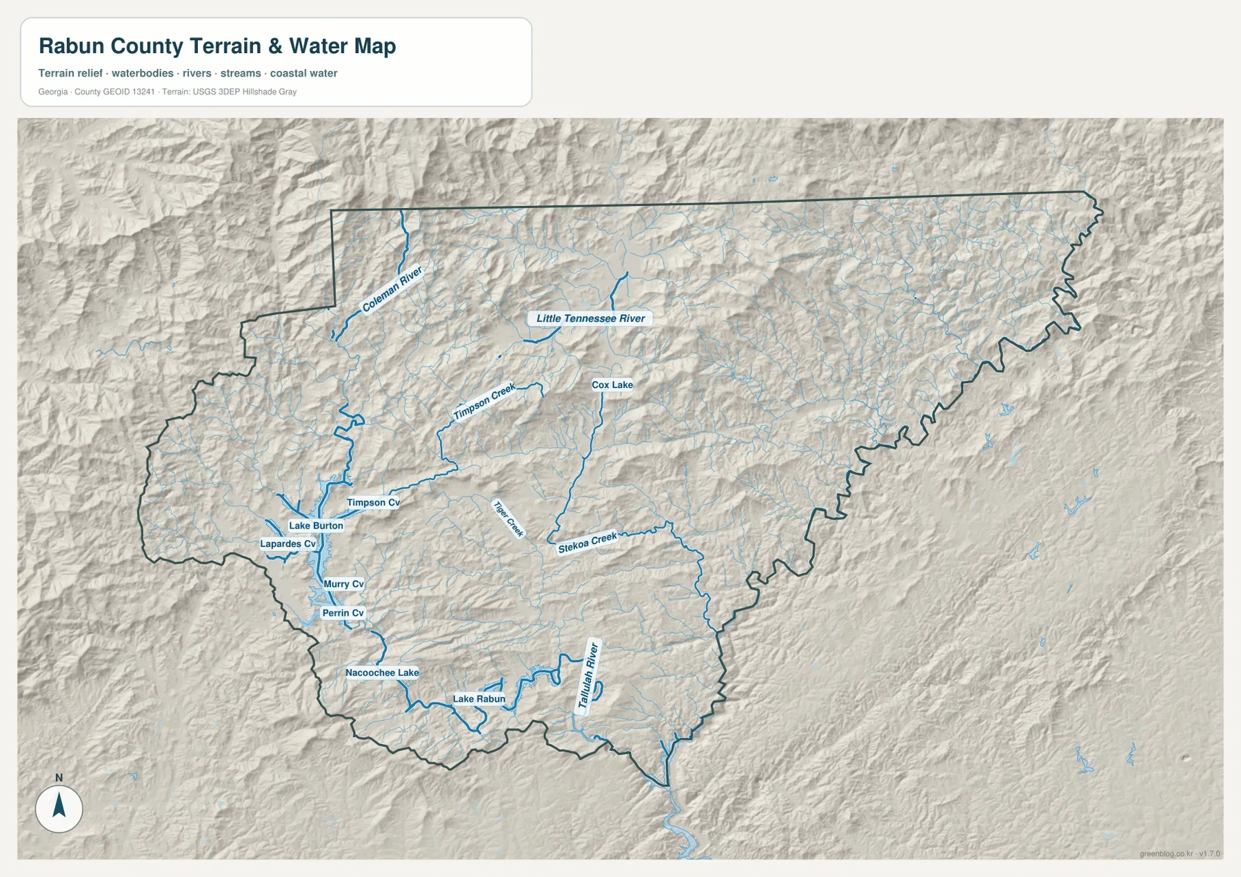
Water is one of the strongest visual features in the county. Lake Burton occupies a large area in the southwest, and Lake Rabun lies farther south near Nacoochee Lake. Around them, the water map labels Timpson Creek, Tiger Creek, Stekoa Creek, and many smaller tributaries that occupy narrow mountain valleys. The Tallulah River is prominent in the southern part of the county, while the Coleman River and Little Tennessee River appear in the north. Cox Lake is also labeled near the north-central interior. Together these features show that Rabun County is not defined by one river alone; its water network is divided among several mountain valleys and lake basins.
Why the water map is more useful than the general map for creek-level detail
The shaded relief behind the blue water lines makes it clear that the streams follow low ground between ridges. Lake Burton has numerous narrow arms, Lake Rabun sits within another confined valley, and the Tallulah River continues through the southern mountain terrain. In the north, the Little Tennessee and Coleman rivers follow a different set of valleys, so the entire county does not drain in one simple direction. When the goal is to find a named creek, understand the shape of a reservoir, or compare northern and southern river systems, this water map provides far more detail than the county reference map.
Elevation from About 270 to 1,425 Meters
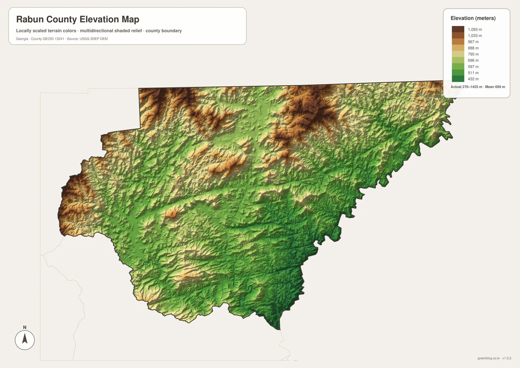
The elevation map records an actual range of roughly 270 to 1,425 meters, with a mean near 699 meters. That spread is unusually large for a single county map and explains the strongly folded appearance of the terrain. Higher ridges show in brown and orange, especially across parts of the north, west, and north-central interior. Lower ground appears in green and follows valley corridors, with broader low areas toward the southeast and along major drainage lines. The map therefore does more than identify a highest and lowest point; it shows how repeated ridges and valleys structure almost the entire county.
Reading roads, water, and elevation together
The four maps become most useful when they are compared rather than treated as separate illustrations. The county map shows where the main roads bend and where towns cluster. The water map then reveals the valleys occupied by lakes and streams, while the elevation map shows the ridges surrounding those valleys. This helps explain why the central corridor is easier to follow than the intricate stream pattern in the east and why reservoirs such as Lake Burton and Lake Rabun have long, narrow arms. It also prevents a common mistake: assuming that a short straight-line distance between two places means the ground between them is simple or flat.
Choosing the Right Map and Downloading the A3 JPG Set
Use the county map when you need boundaries, road numbers, and the general positions of Clayton, Dillard, Mountain City, Sky Valley, Tiger, and Tallulah Falls. Choose the city map for a cleaner town-to-town comparison. The water map is the better reference for Lake Burton, Lake Rabun, the Tallulah River, the Little Tennessee River, and named creeks, while the elevation map is designed for ridge-and-valley comparison. The WebP images on this page are lightweight previews; the downloadable ZIP contains four high-resolution A3 JPG files so the maps can be saved, printed, or inserted into classroom and research materials.
| Map | Best for |
|---|---|
| County map | Boundary, Clayton, major towns, and routes 441/23/15, 2, 76, 197, and 28 |
| City map | Relative positions of the five ranked towns |
| Water map | Lake Burton, Lake Rabun, Tallulah River, Little Tennessee River, and creeks |
| Elevation map | Ridge and valley differences across the 270–1,425 m range |
Frequently Asked Questions
Where are the main towns in relation to Clayton?
Mountain City and Dillard are north of Clayton, Sky Valley is farther northeast, and Tiger lies just south of Clayton. Tallulah Falls appears near the southern edge of the county. The city map gives the clearest simplified view of this arrangement.
Which map is best for Lake Burton and Lake Rabun?
The water map is the best choice because it shows the reservoir shapes together with nearby creeks, river valleys, and terrain. Lake Burton’s branching shoreline and the Lake Rabun–Tallulah River area are much easier to interpret there than on the general county map.
How much elevation change does the map show inside Rabun County?
The elevation map lists an actual range of about 270 to 1,425 meters and a mean of about 699 meters. That wide range is why the shaded terrain shows such pronounced ridges and narrow valleys across the county.
Map File Information
The ZIP contains four high-resolution A3 JPG maps of Rabun County: county, city, water, and elevation.
- Included Files: County map, city map, water map, elevation map
- File Type: Four JPG files in one ZIP
Related Maps
Sources and References
These official and public sources can be used to check county information and the boundary, hydrography, and elevation data behind the map set.
- Official Rabun County website
- New Georgia Encyclopedia – Rabun County
- U.S. Census Bureau TIGER/Line boundary data
- USGS National Hydrography
- USGS 3D Elevation Program
Green Map creates custom-edited map images using open geographic data sources such as geoBoundaries, Natural Earth, OpenStreetMap, and government open data. These maps are edited visual materials, not raw data files, and are provided for education, documents, presentations, and graphic reference.