Download the Bacon County Map package as one ZIP containing four high-resolution A3 JPG files, ready for printing, classwork, reference sheets, or document design. Bacon County sits in southeastern Georgia with Alma functioning as the clear center of county government and everyday travel. The road-and-boundary view shows the main north–south corridor through Alma and Georgia State Route 32 crossing east–west, while the companion maps add settlement, creek, and elevation context for the surrounding rural landscape.
The maps are meant for county-scale orientation rather than parcel research or turn-by-turn navigation. They show where Alma sits inside the boundary, how roads connect the county to its neighbors, which named creeks cross the interior, and how modest elevation differences shape the drainage network. Bacon County is part of Georgia’s Coastal Plain, so its terrain does not rise into mountains or steep ridges. Even so, the supplied elevation surface ranges from roughly 31 to 79 meters, with subtle valleys that become much easier to recognize when the terrain and water maps are viewed together.
Table of Contents
Alma at the Center of the County Boundary and Road Network
The general county map places Alma near the middle of Bacon County and gives the city more visual weight than any other settlement. That is appropriate because Alma is the county seat and the county’s only incorporated city. U.S. Routes 1 and 23 form the principal north–south connection through the area, while Georgia State Route 32 runs east–west through Alma and continues toward Rockingham. Sessoms appears southwest of the city, and the surrounding road pattern shows how a small urban center serves a much larger rural territory.
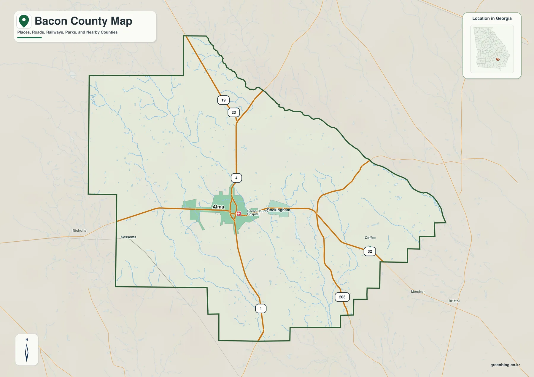
The surrounding geography helps explain why Alma works as a practical reference point. Appling County lies to the north and northeast, Jeff Davis County is toward the northwest, Coffee County is west, Pierce County is southeast, and Ware County is south. From Alma, the east–west road connection leads toward the Coffee and Pierce sides of the county, while the main north–south corridor points toward Appling and Ware. The map is therefore especially useful when a reader needs to understand county position and travel direction without the clutter of every local road or rural address.
The present boundary also reflects the county’s history. Material included with this package states that Georgia created Bacon County in 1914 from parts of Appling, Pierce, and Ware counties and named it for U.S. Senator Augustus Octavius Bacon. Alma had already incorporated in 1906. County government, rail activity, and commerce later concentrated in the same place, so the strong central role of Alma on the map is not simply a cartographic choice; it reflects how the county developed.
Why the City Map Shows One Dominant Center
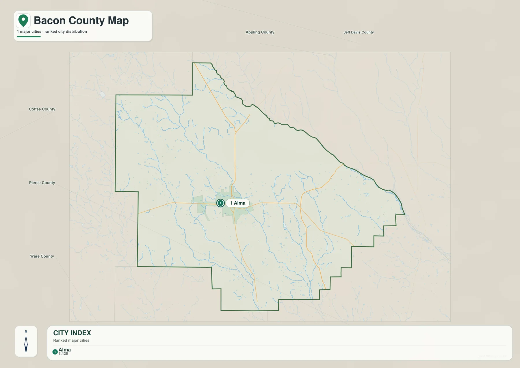
The city-focused map simplifies the settlement pattern even further. Its ranked city index contains Alma as the single major city, with a displayed value of 3,426 in the supplied city dataset. That does not mean Bacon County lacks other named places. Rockingham is identified in the source material as a census-designated place, and Sessoms is an unincorporated community. The map is emphasizing incorporated or major-city structure, not claiming that every resident lives inside Alma.
A Small City Serving a Broad Rural Landscape
Alma’s importance comes from more than population. The county seat concentrates government functions at the same place where the principal road corridors meet. The supplied background material also notes the 1919 courthouse, the historic Alma Depot, and the Rabinowitz Building, linking administration, rail history, and commerce to the same town. Comparing the city map with the general county map makes the contrast clear: one compact center anchors a county whose remaining area is spread across farms, pine land, wetlands, and small communities.
Bacon County is also closely associated with blueberry production, but the agricultural identity belongs to the rural county rather than to a single downtown location. The source article describes pine-based turpentine and naval-stores work as an earlier industry and blueberry farming as a later defining feature. That history fits the map pattern well. Alma provides services and road access, while the larger landscape outside the city contains the working land that gives the county much of its agricultural character.
Hurricane Creek, Tenmile Creek, and the County’s Water Network
The terrain-and-water map shifts attention away from roads and settlements. Several named tributaries stand out, including Little Hurricane Creek and Hurricane Creek in the western and central portions of the county, Tenmile Creek and Grant Creek farther southeast, Little Creek in the northwest, and smaller features such as Bryant Creek and Mill Branch. Instead of one large river dominating the page, the image shows a branching network of creeks crossing low-relief terrain and leaving the county in different directions.
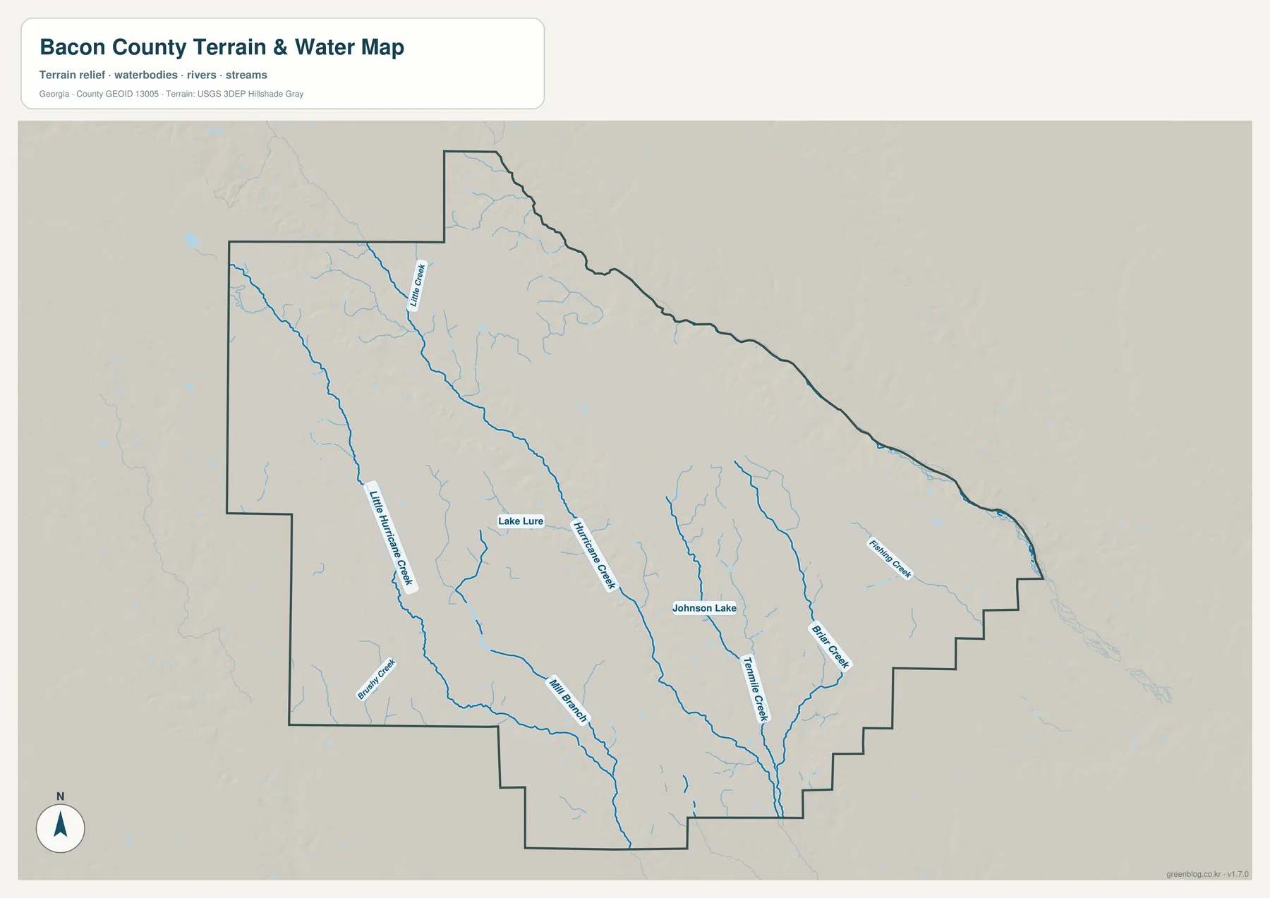
Lake Lure and Johnson Lake provide two additional reference points, while Flashing Creek is labeled toward the eastern side. The supplied county background explains that most of Bacon County belongs to the Satilla River subbasin, whereas parts of the eastern and southeastern edge drain through the Little Satilla subbasin. The water map does not draw that broad subbasin boundary as a heavy administrative line, but the named tributaries help a reader understand why different parts of a relatively small county can feed different local drainage systems.
This map should be used as a geographic reference, not as a flood-hazard, wetland-regulation, legal-boundary, or navigation product. A blue creek line shows the position of a mapped water feature at county scale; it does not tell a property owner how high water may rise, whether a parcel is regulated wetland, or whether a stream is navigable. For those questions, the appropriate current agency layer is necessary. Here, the useful task is simpler: compare creek location with roads, county shape, and the low valleys shown in the elevation map.
A 31–79 Meter Elevation Range Across the Coastal Plain
The elevation map confirms that Bacon County is low-relief Coastal Plain country. Its legend reports an actual range of about 31 to 79 meters and a mean elevation near 56 meters. Browns and oranges mark relatively higher ground across much of the western and northwestern area, while greens highlight lower terrain along creek valleys and across parts of the south and southeast. The difference is modest compared with mountain counties, but it is large enough to organize small drainage corridors across the landscape.
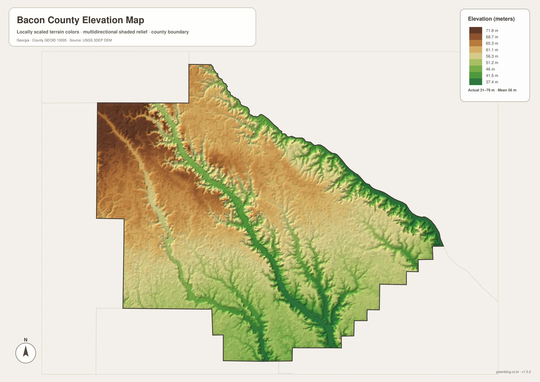
Viewed beside the water map, the elevation image becomes more informative. Long green depressions correspond in several places with the paths of Hurricane Creek and other tributaries. The pattern helps explain how a county that looks nearly flat on a road map can still contain a network of shallow valleys. These are not dramatic canyons or ridges; they are gentle changes in height that guide water across sandy and wet Coastal Plain ground.
The colored surface is generalized for a county-wide view. It should not be treated as survey-grade or engineering-grade elevation at a specific point. A building site, drainage design, road project, or property analysis requires more precise source data and appropriate field or professional verification. For a classroom map, travel reference, county profile, or general geographic comparison, however, the image provides a clear picture of where the higher and lower parts of Bacon County lie.
Choosing the Right Bacon County Map for the Task
Each map is most useful when it answers a specific question. Use the general county map when the priority is boundary shape, Alma, nearby communities, and the main road directions. Choose the city map when the goal is to show how strongly county activity is concentrated in Alma. The water map is better for named creeks, lakes, and drainage context, while the elevation map is the clearest option for comparing higher western ground with lower valleys toward the center, south, and southeast.
- County orientation: compare Alma, Rockingham, Sessoms, the outer boundary, and the major road corridors.
- Settlement pattern: use the city view to show Alma as the only major incorporated center in a predominantly rural county.
- Water geography: follow Hurricane Creek, Tenmile Creek, Grant Creek, Little Hurricane Creek, and the labeled lakes.
- Terrain comparison: use the elevation view to examine the roughly 31–79 meter range and the shallow valleys associated with drainage.
The maps can also be combined in a short research or teaching sequence. Start with the county map to establish place and direction, switch to the city map to discuss settlement concentration, then compare water and elevation to connect creek locations with lower terrain. That sequence builds a more complete picture of Bacon County without crowding one image with every available layer. It also keeps the limits of each map clear, which is important when the same files are reused in presentations or handouts.
Frequently Asked Questions
Are there places to look for besides Alma?
Yes. The general map labels Rockingham east of Alma and Sessoms to the southwest. Their administrative status differs from Alma, however. The supplied material identifies Alma as the county seat and only incorporated city, Rockingham as a census-designated place, and Sessoms as an unincorporated community. That is why the city-focused map gives Alma much stronger emphasis.
How much elevation change is visible in Bacon County?
The supplied elevation map reports an actual range of about 31 to 79 meters, with a mean around 56 meters. Western and northwestern sections are generally higher, while lower green corridors appear along creek valleys and toward parts of the south and southeast. The relief is gentle, but the difference is enough to make the drainage network visible when the elevation and water maps are compared.
Can the water map be used to check flood risk for a property?
No. It is a county-scale reference map showing named creeks, lakes, and terrain context. It does not provide flood-frequency boundaries, regulated wetland limits, parcel lines, or site-specific elevations. Property-level risk or legal questions require the appropriate current official dataset and, when necessary, professional review.
Map File Information
Bacon County A3 Map Files
- Included Files: General county, city, water, and elevation maps
- File Type: Four high-resolution A3 JPG files bundled in one ZIP archive
- Intended Use: Printing, education, presentations, and map-based projects
Related Maps
Sources and Further Reference
Population and county statistics can be checked through the U.S. Census Bureau QuickFacts profile for Bacon County. Historical background, including the county’s creation and local development, is available from the New Georgia Encyclopedia county profile. Local government and planning context can also be reviewed through the official Bacon County website and the Georgia Department of Community Affairs planning records.
For the types of public geospatial data represented by the maps, useful official references include the U.S. Census Bureau TIGER/Line Shapefiles, USGS National Hydrography, and the USGS 3D Elevation Program. These sources are better starting points when a project needs current source data rather than the simplified county-scale presentation used on this page.
Green Map creates custom-edited map images using open geographic data sources such as geoBoundaries, Natural Earth, OpenStreetMap, and government open data. These maps are edited visual materials, not raw data files, and are provided for education, documents, presentations, and graphic reference.