If you are looking for a Morgan County map that can also be downloaded, the easiest place to begin is the Tennessee River and Decatur at the county’s northern edge. The four supplied maps separate the information that is easy to lose on a single page: the county boundary and road network, the six largest mapped cities, named rivers and creeks, and the change in elevation from the low river side to the higher ridges in the south and east. A ZIP containing four original A3 high-resolution JPG files is available in the download box below.
Morgan County is not geographically uniform. Decatur occupies the broad northern river setting, Hartselle and Falkville sit farther south along the main north-south transportation corridor, Priceville and Somerville lead toward the eastern side, and the terrain becomes more rugged toward the southeast. Reading the maps in that order turns a list of place names into a clear picture of how water, roads, settlement, and relief fit together.
Table of Contents
Morgan County begins at the Tennessee River edge
Morgan County lies in north-central Alabama immediately south of the Tennessee River. The supplied article material places Limestone and Madison counties to the north and northeast, Marshall County to the east, Cullman County to the south, and Lawrence County to the west. Decatur, the county seat and largest city, occupies the northwest side of Morgan County where major roads, river crossings, industry, and public services come together.
| State | Alabama |
|---|---|
| County | Morgan County |
| County seat | Decatur |
| 2025 population estimate | 126,483 |
| 2020 census population | 123,421 |
| 2020 land area | 579.67 sq mi |
| 2020 population density | 212.9 per sq mi |
| Key routes shown or documented | I-65, U.S. 31, U.S. 231, AL 24, AL 36, AL 67 |
| Major water feature | Tennessee River / Wheeler Reservoir system |
The source package gives a July 1, 2025 population estimate of 126,483 and a 2020 census population of 123,421. Those totals are useful background, but the maps make a more important geographic point: settlement is concentrated unevenly. The Decatur side has the largest urban footprint, Hartselle forms the next major center to the south, and smaller communities extend along highway corridors rather than filling the county evenly.
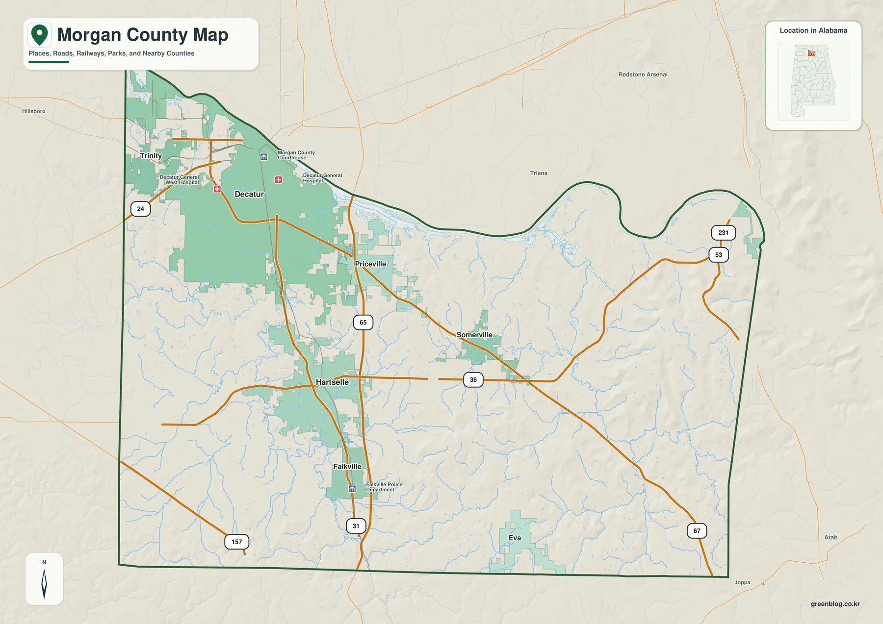
The general county map is the best starting point when you need roads and places together. Decatur occupies the broad northwestern urban area. I-65 and U.S. 31 run generally north-south through the central and western half of the county, while Alabama 36 crosses from the Hartselle area toward Somerville. Alabama 67 continues through the eastern side, and U.S. 231 appears near the northeast. This layout makes it easy to separate the river-oriented north from the inland towns farther south and east.
Six major cities form two different settlement patterns
The city map ranks six major places and prints a value beside each one: Decatur 57,361, Hartselle 15,847, Priceville 3,726, Trinity 2,561, Falkville 1,606, and Somerville 921. These are the figures printed in the supplied city index, so they are best used to compare the mapped cities rather than as a substitute for a separately dated population table. What matters most visually is the gap between Decatur and the other communities and the way the smaller cities follow distinct road corridors.
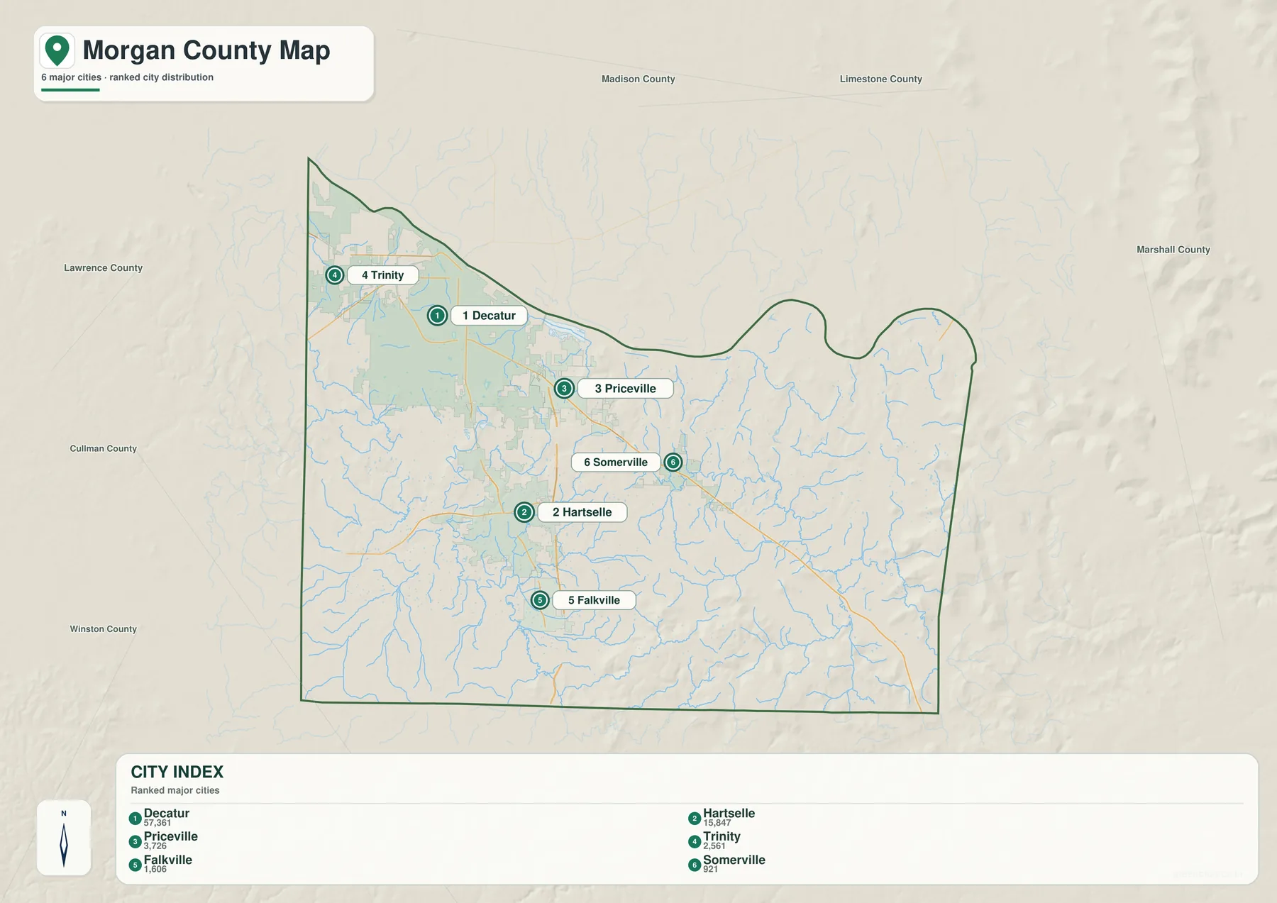
Decatur and Trinity belong to the northern and northwestern side of the county, close to the Tennessee River and the Lawrence County direction. Priceville sits southeast of Decatur near the I-65 corridor, while Somerville lies farther east. Hartselle is the strongest inland center and Falkville continues the same southbound pattern toward Cullman County. This arrangement gives Morgan County a broad northern urban side and a second chain of towns stretching southward.
The source material also explains why these places developed differently. Hartselle grew around the South and North Alabama Railroad, so its older center follows a rail-and-U.S. 31 setting rather than a riverfront. Priceville represents a later transportation pattern tied to I-65, Alabama 67, and access toward the Huntsville area. Decatur, by contrast, combines river crossing, rail history, industry, county government, and a larger urban footprint. The map does not need to show those historical details directly for the contrast to make sense once the city locations are visible.
Eva appears on the general county map but is not part of the six-place ranking on the city map. That distinction is useful: this city map is a simplified comparison of major mapped cities, not a complete inventory of every incorporated place. Use the general map when you need a wider set of labels and the city map when you want a cleaner picture of the main settlement hierarchy.
The Tennessee River dominates a much denser creek network
The water map immediately shifts attention to the county’s northern edge. The Tennessee River runs across the top of Morgan County in a broad, curving band, and the supplied article identifies this reach as part of Wheeler Reservoir. The source package cites TVA figures of 67,070 acres of water surface and 1,027 miles of shoreline for the reservoir as a whole. Those numbers describe the full multi-county reservoir, not only the water inside Morgan County.
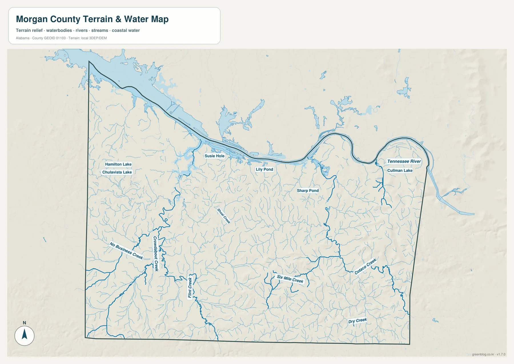
South of the river, the map is filled with smaller drainage lines. Flint Creek is prominent on the western and central side, while Six Mile Creek and Cotaco Creek stand out farther east and southeast. Dry Creek, Mud Creek, and No Business Creek are also labeled. The dense network explains why a simple road map can understate the amount of water in Morgan County: many of the county’s waterways are narrow tributaries rather than large open-water bodies.
The water layer also names smaller features such as Hamilton Lake, Chulavista Lake, Susie Hole, Lily Pond, Sharp Pond, and Cullman Lake. These labels are useful when a project needs more detail than the Tennessee River alone. They should not, however, be interpreted as a flood-risk layer, a legal water-boundary survey, or a navigation chart. This is a reference map for seeing where named water and terrain features occur relative to the county boundary.
The existing county material adds an important conservation context to the northern water landscape. Wheeler National Wildlife Refuge is described as a roughly 35,000-acre area containing river channels, tributary creeks, wetland and floodplain habitats, uplands, and agricultural fields. That information helps explain why the Decatur-Priceville river side can contain urban and industrial land close to extensive water and habitat areas rather than fitting a single land-use pattern.
Elevation rises from the river lowland toward southern and eastern ridges
The elevation map provides the clearest explanation for the county’s physical contrast. Its printed summary gives an actual elevation range of 132 to 403 meters and a mean of 218 meters. Lower green tones dominate the northern side near the Tennessee River, while brighter and brown terrain becomes more common in the south and especially the southeast and east. Morgan County therefore extends well beyond the relatively low Tennessee Valley setting around Decatur.
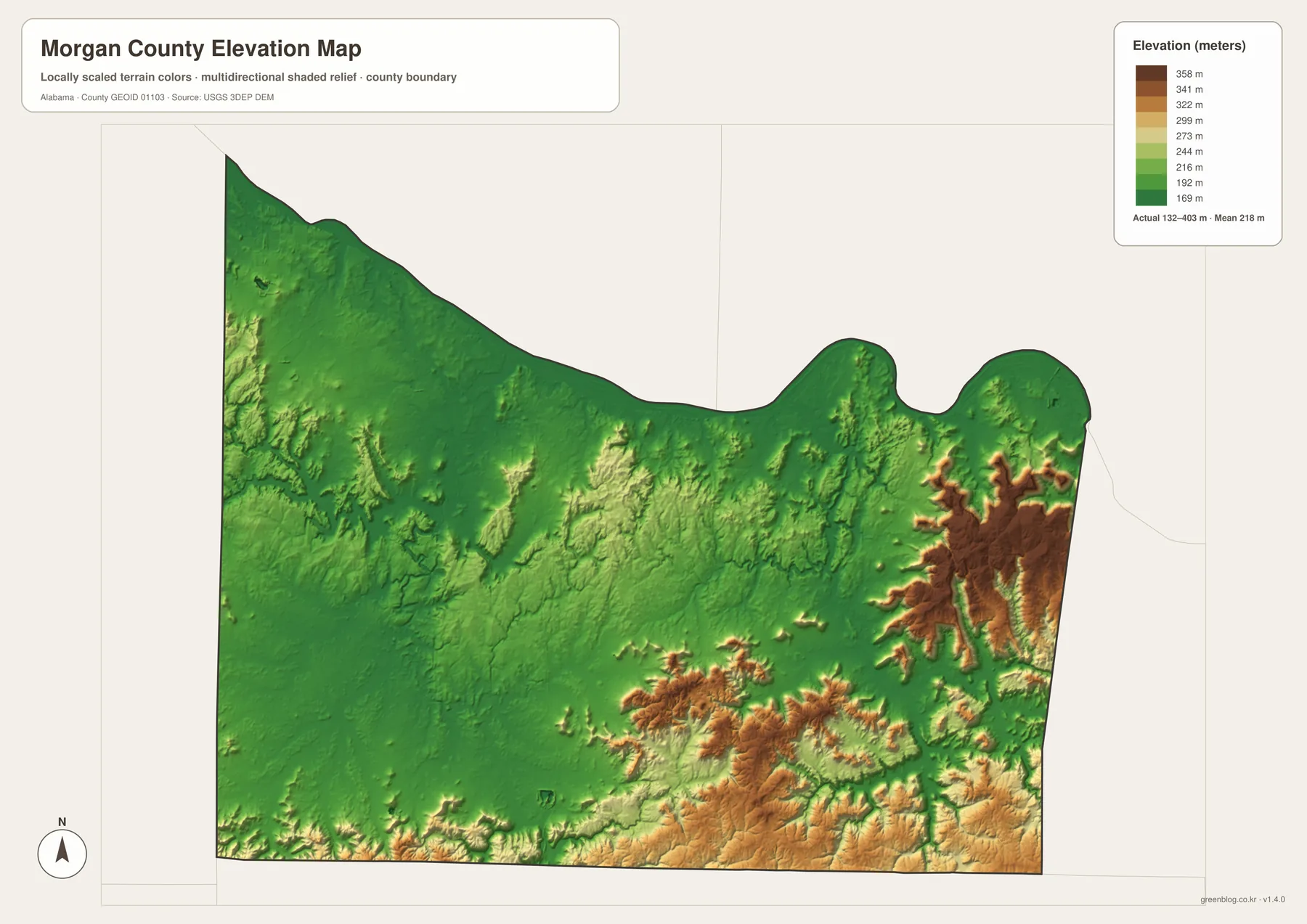
That relief helps explain the different appearance of the settlement map. Decatur and Trinity sit in the lower northern landscape, while the ground becomes more broken south of the river plain. Hartselle and Falkville are surrounded by more rolling terrain, and the eastern and southeastern side contains sharper ridge patterns. Roads and small communities tend to occupy the more practical passages between those higher areas, which is easier to see when the elevation map is compared with the road and city maps.
This elevation surface is meant for regional comparison. It is appropriate for understanding the county’s broad low-to-high pattern, building classroom materials, or adding terrain context to a map project. It should not be treated as survey-grade elevation for a particular parcel, engineering design, drainage calculation, or construction decision.
Roads and river crossings organize travel more than straight-line distance
I-65 and U.S. 31 are the easiest north-south references to follow. U.S. 31 connects established centers such as Decatur, Hartselle, and Falkville more directly, while I-65 carries the stronger regional movement toward the Huntsville approach in the north and Cullman-Birmingham direction in the south. The two routes run through different parts of the county, so using both explains the relationship between older town centers and newer highway-oriented development.
East-west travel is more varied. Alabama 36 runs through the Hartselle-Somerville side, Alabama 67 serves the Priceville and eastern direction, and U.S. 231 appears near the northeast side of the county. The general map also shows Alabama 24 toward the west and additional numbered routes that connect rural areas to the larger highways. These roads are particularly useful for orienting places that are far from Decatur’s dense street network.
The Tennessee River creates another practical constraint. A place across the river may look close on a county map, but vehicles must use available bridges and approach roads. For travel toward Limestone or Madison County, the location of those crossings can matter more than the straight-line distance. Comparing the general map with the water map makes that limitation obvious without needing a separate route-planning layer.
Choose the map by the question you need to answer
Use the general county map when you need boundaries, towns, roads, water, and nearby context on one page. It is the best all-purpose reference for locating Decatur, Hartselle, Priceville, Somerville, Falkville, Eva, and Trinity. The city map is better when the main question is where the six largest mapped places sit relative to one another, because it removes much of the extra detail and emphasizes the settlement hierarchy.
Use the water map for the Tennessee River, named creeks, lakes, and ponds, especially when a project needs to separate the broad northern river from the smaller tributary network. Use the elevation map when terrain matters more than labels: its strongest contribution is the contrast between the low northern river side and the higher ridges in the south and east. Combining all four makes it possible to explain why cities and roads occupy the locations they do without crowding every layer onto a single image.
Frequently Asked Questions
Why is Decatur and the Tennessee River the best place to start?
Decatur is the county seat and largest mapped city, and it sits directly beside the county’s dominant water feature. Once those two references are fixed, you can follow U.S. 31 and I-65 south toward Hartselle and Falkville or move southeast toward Priceville and Somerville. The rest of the county becomes much easier to orient.
Does the city map show every incorporated place in Morgan County?
No. It ranks six major mapped cities: Decatur, Hartselle, Priceville, Trinity, Falkville, and Somerville. Eva is visible on the general county map but not in the six-city ranking, so the general map is the better choice when you need a broader set of place names.
When should I use the water map instead of the elevation map?
Choose the water map when you need the Tennessee River and named tributaries such as Flint Creek, Cotaco Creek, Six Mile Creek, or Dry Creek. Choose the elevation map when you need the broad change in land height, especially the contrast between the lower river side and the higher southern and eastern ridges.
Map File Information
Morgan County map files
- Included Versions: county, city, water, elevation
Related Maps
- Abbeville, Headland, and Lake Eufaula on the Henry County Alabama Map
- Athens to Wheeler Reservoir on the Limestone County Alabama Map
- Autauga County Map
Sources and references
- U.S. Census Bureau QuickFacts — Morgan County population and land-area background
- Morgan County official communities — county community information
- TVA Wheeler Reservoir — Tennessee River and reservoir context
- U.S. Fish & Wildlife Service Wheeler NWR — refuge and habitat background
- USGS 3D Elevation Program — elevation-data reference
Green Map creates custom-edited map images using open geographic data sources such as geoBoundaries, Natural Earth, OpenStreetMap, and government open data. These maps are edited visual materials, not raw data files, and are provided for education, documents, presentations, and graphic reference.