Covington County stretches across south-central Alabama from the Andalusia and Opp area to Florala on the Florida state line. This page brings the county’s roads, municipalities, waterways, and elevation into one map set, with high-resolution A3 JPG files available for download when you need something larger than the on-page previews. The maps are useful for quickly locating Andalusia, following U.S. 84 and U.S. 331, finding Point A Lake and the Yellow River, or comparing the hillier northern part of the county with the lower terrain toward Florida.
The county is long enough from north to south that a single road map does not tell the whole story. Andalusia and Opp anchor much of the central and northern activity, while Florala sits well to the south near the state boundary. Rivers cut through both halves of the county, and the elevation view shows why the northern landscape looks more broken and ridged than the broad lower valleys farther south. Looking at the themes together gives a much clearer picture of how the county fits together.
Table of Contents
Begin with Andalusia and the main road network
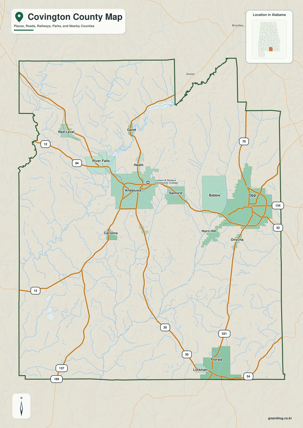
Andalusia is the easiest reference point on the general county map. It sits slightly west of the geographic center, where several routes meet and then fan out toward other communities. U.S. 84 crosses the county from west to east through Andalusia and continues toward Opp. North and northwest of the city are River Falls, Gantt, and Red Level, while Babbie and Opp lie to the east. Florala is much farther south, almost at the bottom edge of the county.
The road pattern makes the county’s long shape practical to follow. U.S. 331 runs through the eastern half and provides a clear north-south link from the Opp area toward Florala. Around Opp, Alabama routes 52 and 134 add local connections, while routes 20 and 55 extend through the central and southern interior. On the west side, U.S. 84 meets roads leading toward Red Level and the rural southwest. The map is not a substitute for live navigation, but it is well suited to understanding which towns share the same corridor and which require a longer cross-county trip.
Covington County’s outline also helps orient the map. The southern boundary is the Alabama-Florida line and is much straighter than the irregular northern edge, where several steps and narrow extensions break up the shape. Butler and Conecuh counties are on the western side, while Coffee and Geneva counties lie to the east. Florala’s position directly beside Florida makes the southern end particularly easy to recognize.
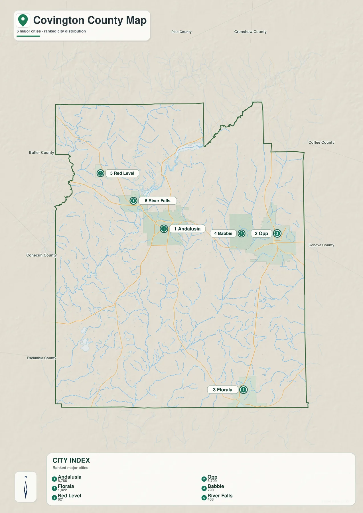
The city map shows how far Florala sits from the main cluster
The simplified city map labels six municipalities: Andalusia, Opp, Florala, Babbie, Red Level, and River Falls. With most secondary labels removed, the spacing between these places becomes much easier to see. Andalusia and Opp form the strongest east-west pair across the middle of the county, and Babbie lies between them, closer to Opp. Red Level and River Falls are both northwest of Andalusia rather than on the same central corridor.
Florala is the clear outlier. It stands near the Florida line, far south of the other five labeled municipalities, which makes the county’s north-south length immediately obvious. This separation is useful context when reading a general map: two places can share the same county but still sit in noticeably different local regions. The city map does not show driving times, but it gives a clean visual comparison of the main named communities before roads and terrain are added back in.
The numbered markers are ranking labels rather than route steps. They are best used for locating the cities quickly in a classroom handout, presentation, or county overview. For trip planning, the general map and a current navigation service provide the more useful road detail.
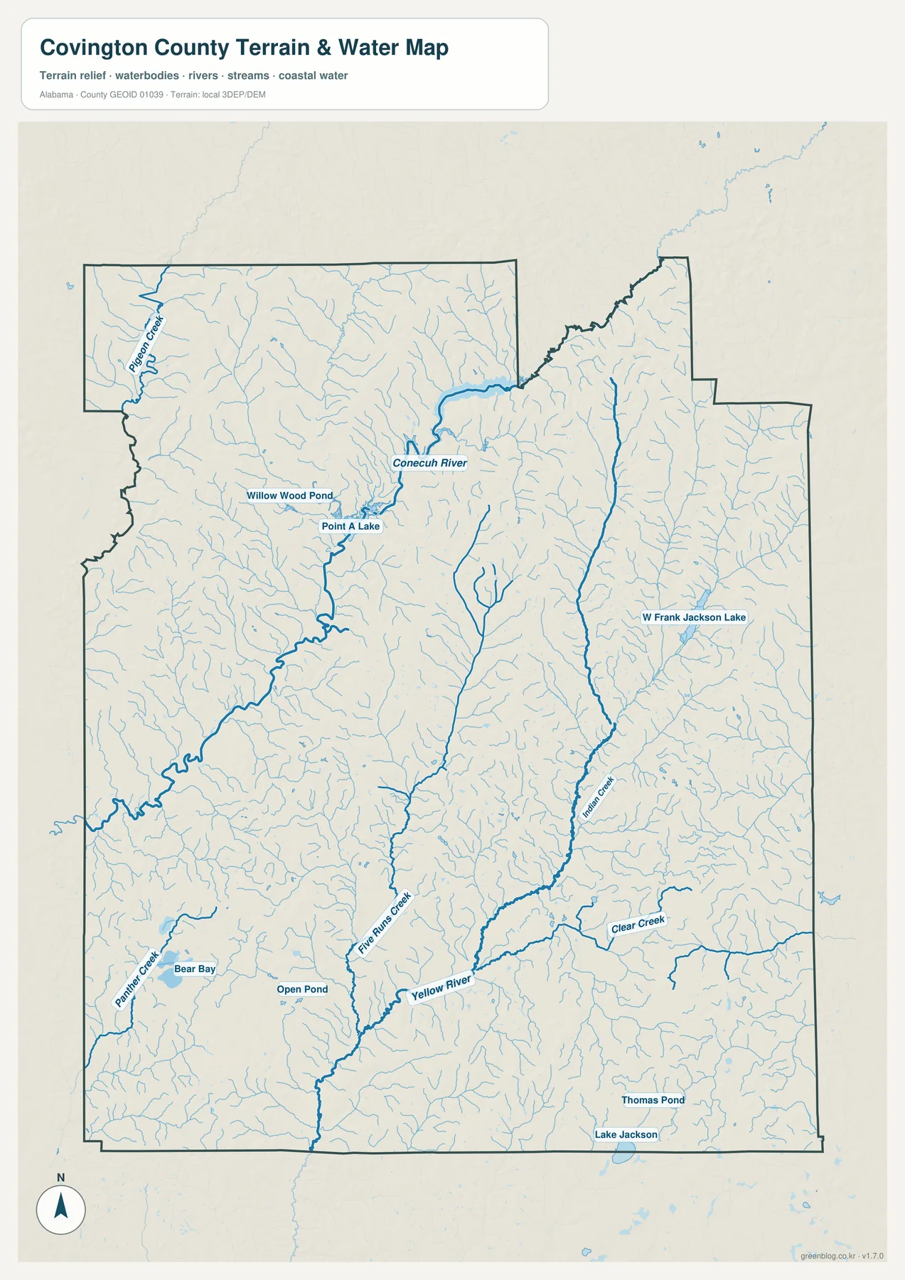
Conecuh River and Point A Lake define the north-central water map
Once roads are removed, the north-central county is dominated by the Conecuh River system. The river bends through the area north of Andalusia, and Point A Lake appears along that system with Willow Wood Pond nearby. Pigeon Creek is labeled farther northwest. Numerous smaller tributaries spread across the surrounding uplands and feed toward the larger channels, creating a dense network that is easy to miss on a road-focused map.
Point A Lake is a particularly useful landmark because it links the city and water views. On the general map, Andalusia is the obvious road center; on the water map, the lake and Conecuh River sit just to the north of that city. That relationship makes it easier to place the reservoir without needing a long list of coordinates or local road names.
The Yellow River organizes the southern drainage
Farther south, the Yellow River becomes the main reference. Five Runs Creek and Indian Creek extend through the interior toward the southern river system, while Clear Creek appears in the southeast. The southwest includes Panther Creek, Bear Bay, and Open Pond. Near the Florida line, Lake Jackson and Thomas Pond add more recognizable water features, and W Frank Jackson Lake appears on the eastern side of the county.
This is a geographic reference map rather than a live conditions map. It does not provide gauge readings, flood stages, boating restrictions, or property-level flood risk. For those decisions, current USGS, state, or local data should be checked. Its strength is in showing how the county’s named lakes, rivers, and creeks relate to one another across a large area.
Elevation changes from ridged north to broader southern lowlands
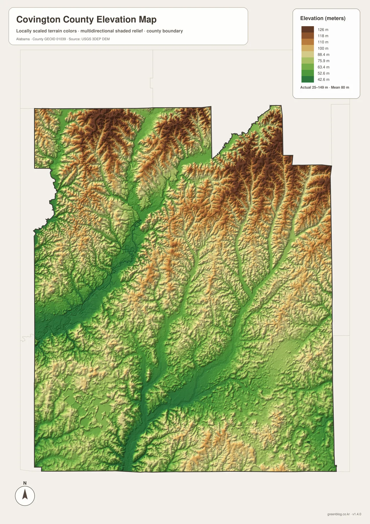
The elevation map explains why the county’s northern half looks so dissected by streams. Brown and orange tones cover many of the ridges near the northern boundary, especially in the northwest and northeast. Narrow green valleys cut between those higher areas, often following the same general lines as the streams shown on the water map. The result is a much rougher landscape than the simplified road map suggests.
Moving south, broad green and yellow areas become more common. Long lower corridors extend through the center and widen toward the Florida line. Florala sits in a generally lower-relief setting than the northern uplands, although the southern county is not perfectly flat. Smaller ridges and shallow valleys remain visible, and they continue to guide the creek network.
The legend shows locally scaled elevation bands from roughly 42.6 to 126 meters, while the map notes that the full terrain range extends beyond those labeled bands. This makes the image most useful for relative comparison. It can show which parts of the county are generally higher or lower, but precise engineering, surveying, or property work should use authoritative elevation data instead of reading an exact value from the illustration.
Choose the map that fits the question
For a quick county overview, the general map is the best starting point because it combines communities, highways, smaller roads, the boundary, and a light water layer. If the goal is to compare only the principal municipalities, the city view is cleaner and makes the separation between Florala and the central cluster obvious. The water map is more useful when the question involves Point A Lake, the Conecuh River, the Yellow River, or named creeks, while the elevation map explains the broader landform differences behind those drainage routes.
Andalusia illustrates how the themes complement one another. The road map shows it as a central junction on U.S. 84, the city view places it between the northwestern towns and Opp, the water map puts the Conecuh River and Point A Lake just to the north, and the elevation view shows the city near the transition between higher northern ridges and lower southern valleys. Florala provides an equally useful contrast because its location near the state line, Lake Jackson, and gentler southern terrain gives it a very different setting.
Use the files for printing, classrooms, and presentations
The WebP images on this page are convenient for browsing, but the downloadable set is intended for situations where a larger image is useful. A county overview can work well in a presentation, the city map can simplify a classroom comparison, and the water or elevation map can support a discussion of rivers and landforms. Because the archive keeps the themes as separate JPG files, you can use only the map that fits your project rather than placing every layer on one crowded image.
Frequently Asked Questions
Where is Florala within Covington County?
Florala is near the southern end of Covington County on the Alabama-Florida line. U.S. 331 reaches the city from the north, and Lake Jackson is shown near the state boundary.
How is Point A Lake related to the Conecuh River?
Point A Lake lies in the Conecuh River system north of Andalusia. Comparing the general and water maps makes the lake’s position relative to the county seat and surrounding streams easy to see.
What is included in the download?
The ZIP includes four separate A3 landscape JPG files: a general county map, a city map, a water map, and an elevation map. They are higher-resolution versions intended for printing or larger-format use.
Map File Information
Download the Covington County map set as separate high-resolution A3 landscape JPG files.
- Included Files: County map, city map, water map, elevation map
- File Type: 4 high-resolution A3 landscape JPG files in one ZIP
- Intended Use: Printing, education, presentations, and map-based projects
Related Maps
- Along the Cahaba Valley: Bibb County Alabama Map
- Between Two River Systems: A Clarke County Alabama Map
- Calhoun County Alabama Map
Sources and local reference
- Covington County official municipalities information
- Alabama DOT Covington County functional-classification map
- Outdoor Alabama: Point A Reservoir
- City of Florala official website
- USGS 3D Elevation Program
These maps are intended for geographic reference and general educational use. For current road closures, official boundary decisions, water levels, flood risk, property boundaries, or exact elevation measurements, consult the appropriate agency and the most recent authoritative data.
Green Map creates custom-edited map images using open geographic data sources such as geoBoundaries, Natural Earth, OpenStreetMap, and government open data. These maps are edited visual materials, not raw data files, and are provided for education, documents, presentations, and graphic reference.