A Yilan County Map is useful when you need more than a simple location marker for northeastern Taiwan. Yilan County sits between Taiwan’s mountain interior and the Pacific coast, with flatter urban and rural areas around Yilan City, Luodong, Wujie, Dongshan, and Jiaoxi, while larger mountain-side areas such as Datong and Nan’ao stretch across a very different landscape. Because of this mix of coastline, plain, and mountains, a printable administrative map makes the county much easier to explain in travel materials, classroom resources, regional comparisons, and visual presentations.
This printable Yilan County map collection includes three versions: a color map, a black and white map, and an outline map. The files are prepared as image files for printable use, presentation graphics, blog visuals, educational handouts, and editable map projects. The color version is designed for quick regional comparison, the black and white version works well for document printing, and the outline version gives designers, teachers, and students a clean base map for adding labels, routes, colors, or data.
Yilan County is located on Taiwan’s northeast coast, near the Taipei metropolitan region but separated from it by mountainous terrain. Its administrative center is Yilan City, and the county includes areas such as Luodong, Su’ao, Toucheng, Jiaoxi, Yuanshan, Zhuangwei, Wujie, Dongshan, Sanxing, Datong, and Nan’ao. When preparing this map collection, the main focus was not only the county outline but also the relationship between coastal settlements, plain areas, and wider mountain townships. That layout is what makes a labeled and printable Yilan County Map more helpful than a basic regional locator. The source Korean draft and rewrite prompt provided the original map details and intended structure for this English version.
Table of Contents
Map Collection Overview
The Yilan County Map collection is organized for users who need a visual reference rather than a long geographic description. Teachers can use it for Taiwan geography lessons, bloggers can add it to travel posts, and presentation creators can use the map to explain the county’s position between Taipei, the Pacific coast, and eastern Taiwan.
The included versions support different types of work. A color map helps readers compare administrative areas quickly. A black and white map keeps labels and boundary lines clear when printed. A blank outline map gives users space to add travel routes, highlighted townships, statistical data, or custom labels.
Regional Layout of Yilan County
Yilan County is shaped by a clear contrast between the Pacific coast and the mountainous western and southern areas. The central plain around Yilan City and Luodong feels much more compact than the large upland areas of Datong and Nan’ao. This contrast is one of the main reasons a map is helpful for understanding the county.
A written description can explain that Jiaoxi is known for hot springs, Su’ao is connected to the coast and harbor area, and Luodong is an important urban center, but the spatial relationship is easier to understand visually. A Yilan County Map also helps show why some administrative areas appear small and dense while others cover much wider mountain or coastal land.
Color Map for Administrative Comparison
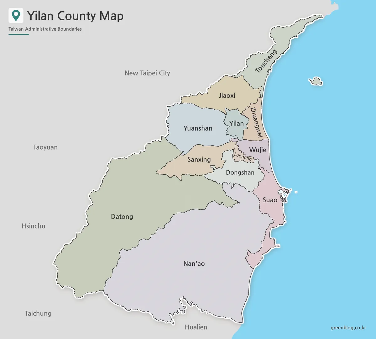
Designed with township and city boundaries in mind, the color version helps separate the different administrative areas of Yilan County at a glance. This is especially useful because the flatter northern and central areas contain several closely placed names, while the larger mountain-side regions take up much more map space.
The color layout works well for blog graphics, classroom slides, and regional explanation pages. It allows users to compare areas such as Yilan City, Luodong, Wujie, Dongshan, Jiaoxi, Su’ao, and Nan’ao without relying only on text labels. For presentations about northeastern Taiwan, the color-coded style gives the map a clearer visual hierarchy.
Black and White Printable Map
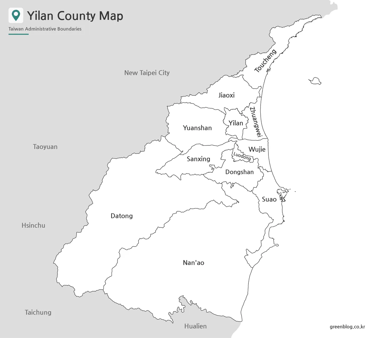
For printed worksheets, reports, and document inserts, the black and white version keeps the design cleaner. Instead of using color to separate areas, it focuses on boundary lines and readable place names. This makes it easier to print multiple copies or mark locations by hand.
Yilan County has both compact label areas and wide boundary sections, so the balance between line weight and label spacing matters. The black and white version was prepared with readability in mind, especially for users who need a simple reference sheet for school assignments, travel planning documents, or printed study materials.
Outline Map for Editing and Custom Labels
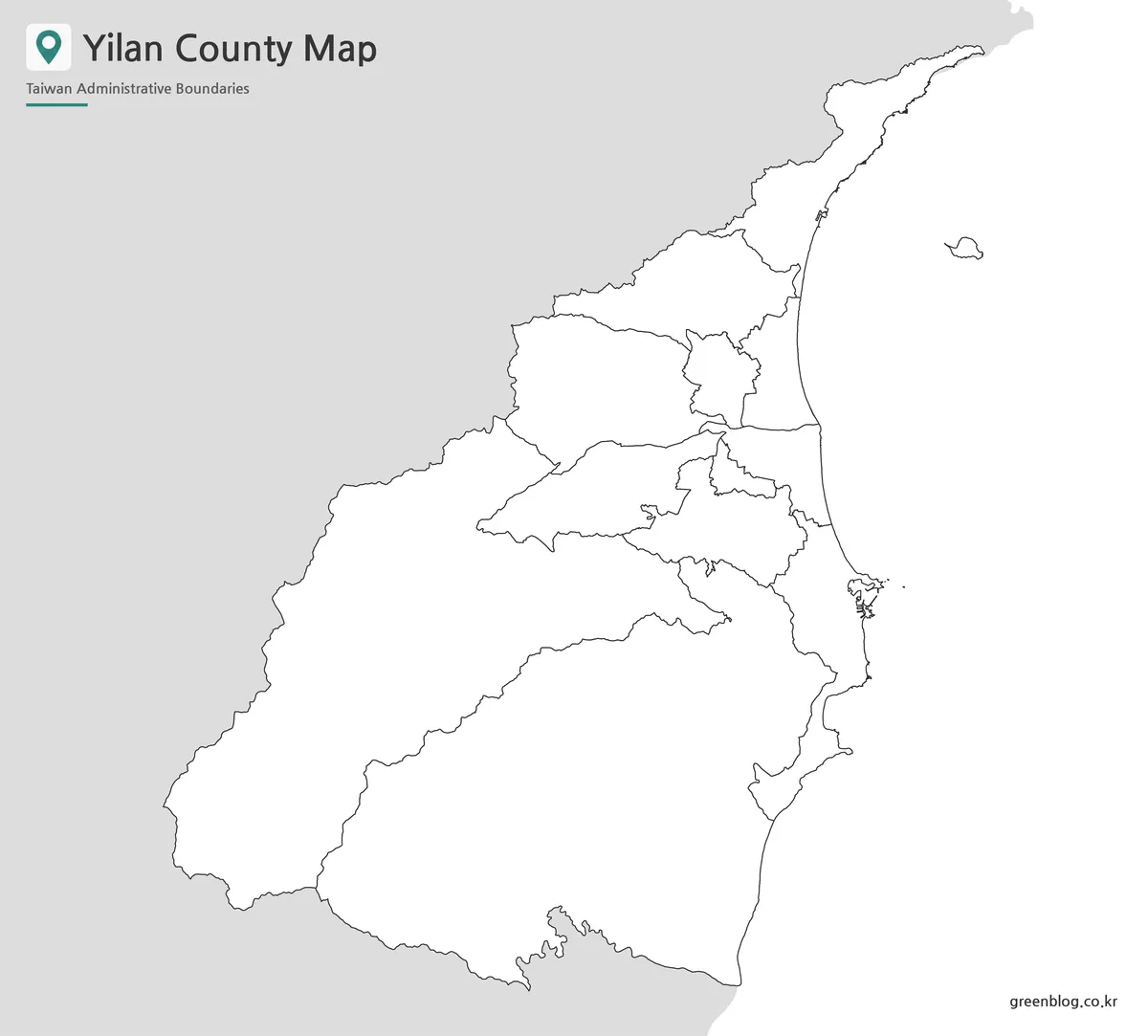
The outline version removes color and labels so users can build their own map design. It works well as a blank base map for travel route planning, classroom coloring activities, infographic projects, or custom regional highlights.
For Yilan County, an outline map is especially useful when showing different themes, such as coastal travel routes, hot spring areas around Jiaoxi, urban locations around Yilan City and Luodong, or mountain-side areas such as Datong and Nan’ao. Designers can add their own colors or markers without having to remove existing visual elements first.
Practical Uses for the Yilan County Map
This map collection is suitable for a wide range of projects. In travel content, it can help explain routes from Taipei toward Yilan, Jiaoxi, Luodong, Su’ao, or Nan’ao. In classroom materials, it can support lessons about Taiwan’s counties, coastal geography, and the relationship between mountains, plains, and administrative divisions.
Bloggers and infographic creators may prefer the color map for quick visual explanation, while teachers and students may use the black and white version for handouts. The outline version is better when the goal is to add custom labels, highlight selected townships, or create a clean visual base for a presentation.
Choosing the Right Version
Choose the color map when the main goal is fast visual comparison. It is the easiest version to understand at a glance and works well for slides, blog posts, and regional overview graphics.
Choose the black and white map when printing matters more than color. It is a practical option for reports, classroom materials, worksheets, and reference pages where labels and boundaries need to remain clear.
Choose the outline map when you need a flexible base. It is the best option for editing, coloring, marking routes, creating infographics, or adding your own information to the Yilan County Map.
Frequently Asked Questions
What is included in this Yilan County Map collection?
The collection includes a color map, a black and white map, and an outline map. Each version is designed for a different purpose, such as printing, presentations, classroom use, or editing.
Is the outline map suitable for editing?
Yes. The outline version is made for users who want to add their own colors, labels, travel routes, or regional data.
Can I use the black and white map for classroom printing?
Yes. The black and white version is a good choice for worksheets, handouts, and printed reference materials because it keeps the layout simple and readable.
What makes a Yilan County Map useful for travel content?
Yilan County includes coastal areas, mountain townships, and urban centers spread across different parts of northeastern Taiwan. A map helps readers understand travel routes and regional relationships more clearly.
Download Yilan County Map
This download includes printable Yilan County map versions for educational use, presentation design, document printing, and editable graphic projects.
- Included Versions: Color map, black and white map, outline map
- Printable Size: A3 layout
- File Type: Image files
- Intended Use: Classroom handouts, presentations, blog graphics, infographic editing, and printable reference materials
Additional Resources
- OpenStreetMap – Yilan County : OpenStreetMap is useful for checking roads, coastal areas, place names, and surrounding regional context in Yilan County.
Related Maps
- Kaohsiung City Map – Printable District Map Collection
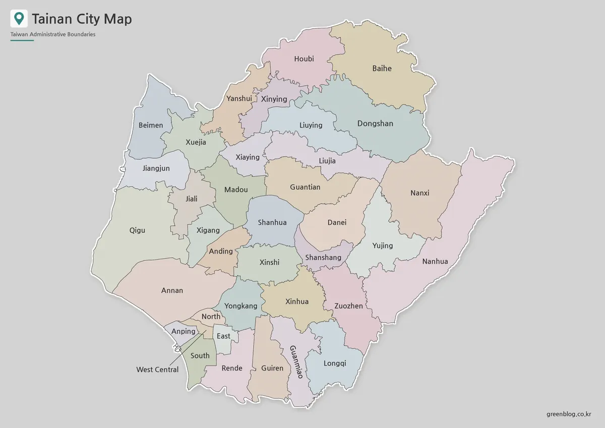
- High Resolution Tainan City Map for Printing and Editing
- Taichung City Map for Printing, Editing, and Classroom Use
- High Resolution Taoyuan City Map for Classroom and Presentation Use