Wayne County occupies a creek-cut part of northeastern Nebraska, with the City of Wayne serving as the county seat and Carroll, Winside, Hoskins, and Sholes spread across the western side. This Wayne County Nebraska Map page combines Nebraska Highways 35, 15, and 57 with straight-line city connections, Deer Creek and South Logan Creek, and an elevation view that shows higher western uplands descending toward lower eastern terrain. The WebP previews are for quick viewing, and the same four maps can be downloaded below as high-resolution JPG files in one ZIP archive. High-resolution map files are available for download in the section below.
Wayne is the easiest place to use as an anchor. Nebraska 35 crosses the city from west to east, while Nebraska 15 provides the main north-south route. Carroll and Winside lie to the west, Hoskins is farther southwest, and Sholes is near the northwestern side. Wakefield appears at the eastern edge as another useful regional reference point.
Table of Contents
Wayne at the meeting point of Nebraska 35, 15, and the county road network
The general county map makes Wayne the strongest transportation reference. Nebraska 35 passes through the city and continues east toward Wakefield, while Nebraska 15 runs north-south through the Wayne area. Nebraska 55 extends westward across the county, and Nebraska 57 connects the Carroll and Winside side. Nebraska 98 appears near Carroll, with Nebraska 16 close to the southeastern edge.
Carroll lies west and slightly north of Wayne, while Winside sits farther south along the same broad western road corridor. Hoskins is near the southwestern corner and Sholes marks the northwest. These communities are separated by large areas of farmland and rolling terrain rather than forming a continuous urban strip. The eastern side toward Wakefield has fewer large town labels, but it is crossed by a dense network of small drainage valleys.
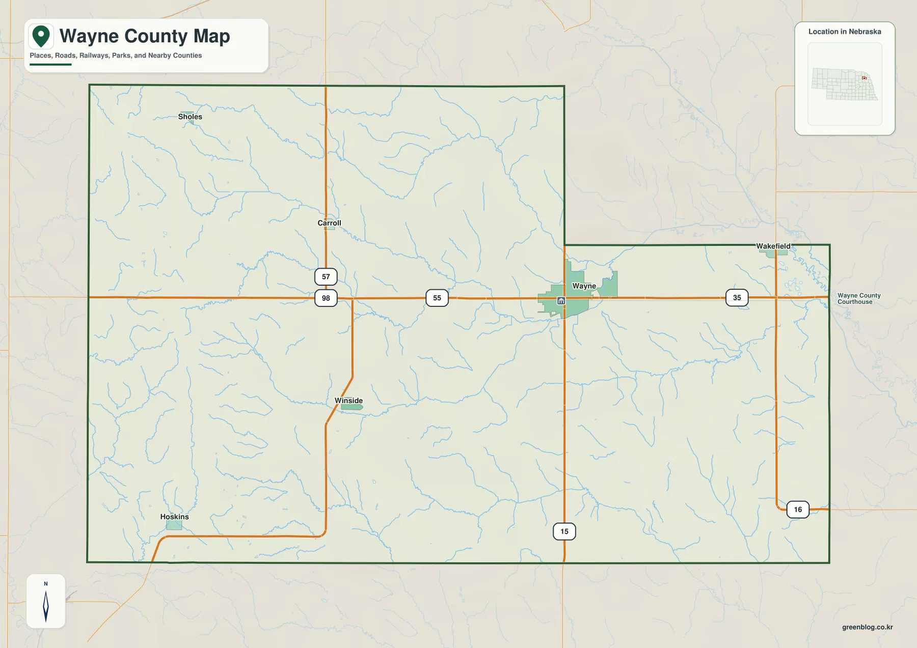
The official county history lists Wayne along with Carroll, Hoskins, Sholes, and Winside among the county’s present communities. Wayne contains county government and the strongest concentration of services, which matches its prominent map position. The smaller western places are useful orientation points for understanding how widely settlement is spaced across the rural landscape.
This map is a regional reference rather than a live navigation product. Construction, detours, and seasonal road conditions can change after a static image is produced. Its value lies in orientation: readers can quickly see where Wayne sits relative to Carroll, Winside, and Hoskins and how Nebraska 35 connects the county seat with the Wakefield side.
Straight-line connections from Wayne to Carroll, Winside, Sholes, and Hoskins
The city-connections graphic uses Wayne as the hub and links it with four smaller communities. Wayne ranks first, followed by Winside, Carroll, Hoskins, and Sholes. Because most road detail is removed, the graphic emphasizes direction, spacing, and the strong central role of Wayne.
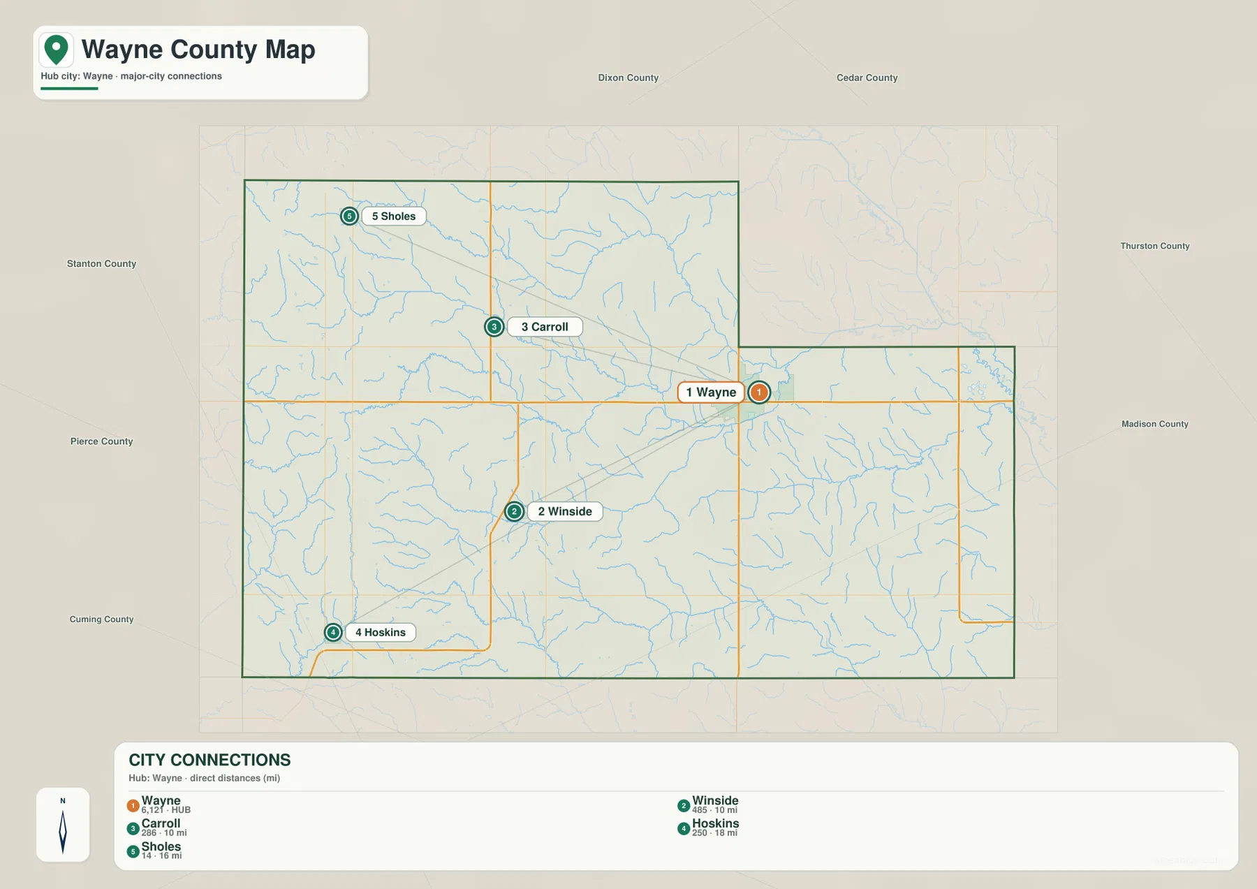
The panel shows about 10 miles from Wayne to Carroll, 10 miles to Winside, 16 miles to Sholes, and 18 miles to Hoskins. These are straight-line distances, not road mileage. Actual driving distances can be longer because roads follow section lines, creek crossings, and the available highway network instead of a direct line.
Carroll and Winside are almost equally distant from Wayne but lie in different directions, with Carroll to the northwest and Winside to the southwest. Hoskins is the farthest ranked community from the hub, while Sholes marks the more remote northwestern side. Current population totals should be checked against the latest Census or local estimates when exact numbers matter; the map works best as a county-scale spacing guide.
Deer Creek, South Logan Creek, and a county built around many small valleys
Deer Creek is one of the most prominent waterways on the terrain-and-water map. It enters from the northwest and runs toward the center of the county, where South Branch Deer Creek approaches from the southwest. Dog Creek also descends from the north, and the channels begin to form a connected set of valleys across the central uplands.
South Logan Creek crosses the middle of the county from west toward east and creates another broad low corridor. Plum Creek lies farther south, while Coon Creek crosses the eastern interior. Chapin Creek and Turtle Creek add separate western drainage lines. The result is a landscape shaped by many medium and small streams rather than one dominant river.
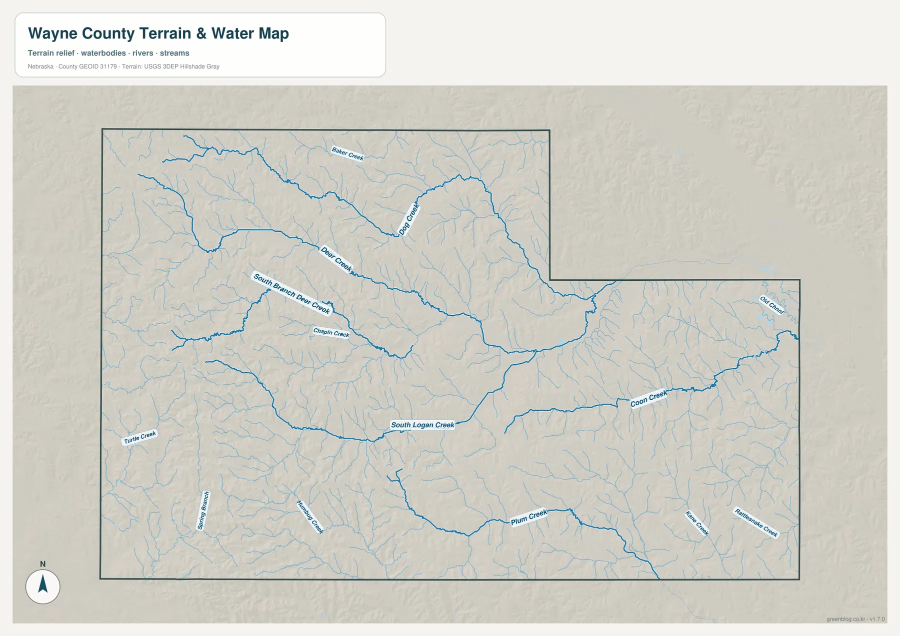
This dense drainage network helps explain the rolling appearance of the county. Narrow valleys repeatedly cut the western and central uplands, while the eastern half opens into somewhat lower terrain. A simple road map can make the rural grid look regular, but the water map reveals far more topographic variation between those roads.
Blue line thickness and color should not be interpreted as measurements of discharge, depth, or flood risk. The image is designed to show where streams and channels are located. Floodplain determinations, stream access, property restrictions, and safety questions require current information from FEMA, USGS, or the appropriate local agencies.
Higher western uplands above lower eastern creek country
The elevation map shows a strong west-to-east difference. The displayed surface ranges from about 412 to 583 meters, with a mean near 489 meters. Brown and orange dominate the western edge, where the county’s highest ridges appear. Greens become more common toward the center and east as elevation generally decreases.
Deer Creek and South Logan Creek form long lower corridors through the uplands, with tributaries cutting narrow valleys into the surrounding hills. Coon Creek and Plum Creek line up with lower green terrain farther east and south. Around Winside and the southwestern side, higher ridges stand out in warmer colors and stronger shaded relief.
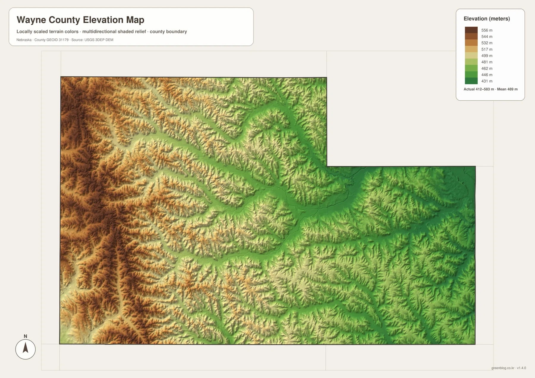
Wayne and the Wakefield side are lower overall than the western boundary, but the landscape remains dissected by many tributaries. The shaded relief makes narrow ridges and branching valleys visible even where the road network looks simple. Comparing the water and elevation maps shows that most of the green corridors follow the same named creeks.
This elevation surface is intended for county-scale comparison, not parcel surveying or engineering. Exact site elevations, road grades, construction benchmarks, and design values require USGS source data, professional surveying, or another appropriate technical source. Here the image is most useful for comparing the western uplands, central creek valleys, and lower eastern half.
From LaPorte to Wayne: how the county seat followed the railroad era
Wayne County’s official history says the county was organized in the fall of 1870 by proclamation of Nebraska Governor David Butler, with its legal organization completed in 1871. The county and the City of Wayne were named for Revolutionary War General Anthony Wayne. Early county settlement included communities that later disappeared as transportation routes changed.
LaPorte once served as an important early center and had a courthouse, but the railroad chose a route elsewhere. The county’s Wayne history page explains that residents platted the town of Wayne in 1880 in anticipation of the railroad, and the line reached the community in 1881. The county seat moved from LaPorte to Wayne in March 1883, reinforcing Wayne’s long-term role as the county’s administrative and commercial center.
Other western communities also reflect the railroad era. History Nebraska records, for example, describe Winside as the result of competition between two possible railroad town sites, with the successful location becoming the modern village. Carroll, Hoskins, and Sholes likewise form part of the county’s dispersed settlement pattern along former rail and agricultural corridors.
A practical way to compare towns, creeks, and relief
Begin with the general county map by locating Wayne and then Carroll, Winside, Hoskins, and Sholes. The city-connections graphic gives a second view by showing straight-line spacing from Wayne to those four communities. Because the displayed mileage is not driving distance, it works best as a quick scale reference rather than a route-planning tool.
Next, use the water map to trace Deer Creek, South Logan Creek, Coon Creek, and Plum Creek. The elevation image then shows how those waterways occupy lower corridors between higher ridges. The contrast is especially clear between the high western side and the lower eastern half of the county.
High-resolution JPG files are better suited to printing and close inspection when small creek names and route numbers matter. These maps remain regional references rather than legal or safety documents. County boundaries can be checked against Census TIGER/Line data, waterways against USGS National Hydrography, and elevation against the USGS 3D Elevation Program.
Frequently Asked Questions
Are the Wayne-to-Carroll, Winside, Hoskins, and Sholes mileages driving distances?
No. The city-connections map shows straight-line distances of about 10 miles from Wayne to Carroll, 10 miles to Winside, 16 miles to Sholes, and 18 miles to Hoskins. Actual road mileage can be longer because roads follow the local network rather than a direct line.
Which waterways stand out in Wayne County?
Deer Creek and South Logan Creek are two of the most prominent streams, with South Branch Deer Creek, Coon Creek, Plum Creek, Dog Creek, and several smaller tributaries cutting valleys across the county.
Can the elevation map be used for surveying or engineering?
No. It is designed to compare western uplands, creek valleys, and lower eastern terrain at county scale. Exact site elevations, road grades, and engineering benchmarks require appropriate USGS source data or professional surveying.
Map File Information
Download the four high-resolution JPG maps shown on this page for Wayne County in one ZIP archive.
- Included Files: Use only the versions confirmed in the article and supplied images
- File Type: Use the confirmed download contents
- Intended Use: Printing, education, presentations, and map-based projects
Related Maps
Sources and references
County organization, Wayne county-seat history, and early settlement background come from official Wayne County pages and History Nebraska. The federal sources below provide authoritative references for boundaries, hydrography, and elevation.
- Wayne County – History
- Wayne County – Wayne History
- History Nebraska – Wayne County Records
- U.S. Census Bureau – TIGER/Line Shapefiles
- USGS – National Hydrography
- USGS – 3D Elevation Program
Green Map creates custom-edited map images using open geographic data sources such as geoBoundaries, Natural Earth, OpenStreetMap, and government open data. These maps are edited visual materials, not raw data files, and are provided for education, documents, presentations, and graphic reference.