Thurston County occupies a distinctive part of northeastern Nebraska, with Pender serving as the county seat and communities such as Walthill, Winnebago, Macy, Rosalie, and Thurston spread toward the Missouri River. This Thurston County Nebraska Map page combines the county road network with ranked community connections, the Missouri River and Omaha-Blackbird creek systems, and an elevation view that shows higher western hills descending toward lower eastern river country. The WebP previews are for quick viewing, and the same four maps can be downloaded below as high-resolution JPG files in one ZIP archive. High-resolution map files are available for download in the section below.
Pender and the Missouri River make useful opposite anchors. Pender sits in the southwest and functions as the county government center, while the river forms the winding eastern edge. Walthill and Winnebago lie to the northeast of Pender, Macy is close to the river, Rosalie is farther south, and the small community of Thurston lies just north of Pender. The county’s settlement pattern is therefore dispersed rather than concentrated in one urban cluster.
Table of Contents
From Pender toward Walthill, Winnebago, and the Missouri River communities
The general county map makes Pender the most convenient starting point. Nebraska 94 runs east from the Pender area toward Walthill, while Nebraska 9 provides a north-south connection near the county seat. Nebraska 16 approaches from the west. Farther east, the road network becomes denser around Walthill and Winnebago before continuing toward Macy and the Missouri River side of the county.
Winnebago lies in the northeastern part of the county and connects south toward Walthill along a major north-south route. Walthill sits closer to the center of the eastern half, making it an important reference between Pender and Winnebago. Macy lies still farther east, near the curved county boundary, with Nebraska 75 continuing southward. Rosalie occupies the southern interior and Thurston is much closer to Pender on the west side.
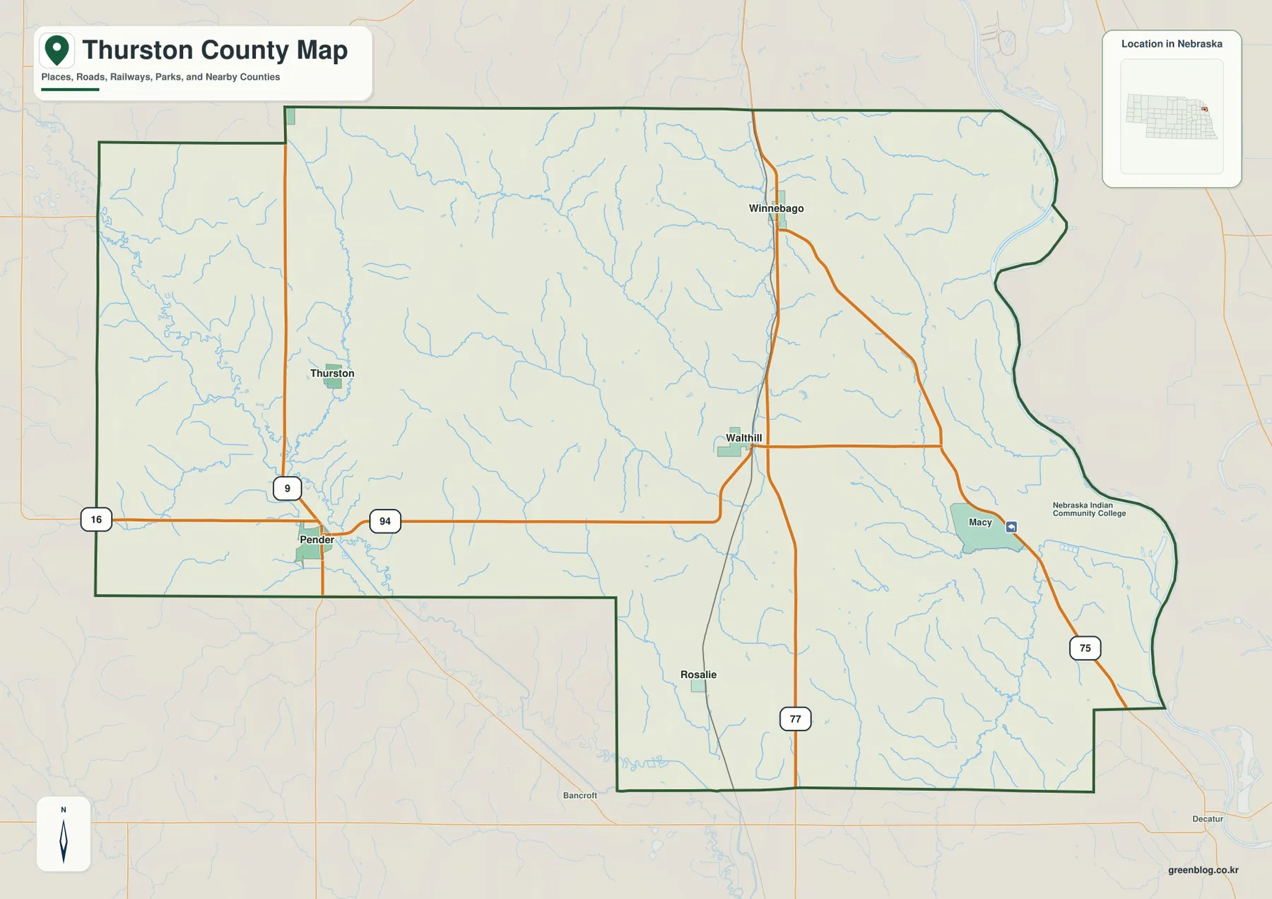
The official county website lists Emerson, Macy, Pender, Rosalie, Thurston, Walthill, and Winnebago among the county’s communities. It also notes that Emerson is unusual because parts of the town lie in Thurston, Dixon, and Dakota counties. Emerson is not a dominant label on the supplied map, so the boundary remains important when reading the far northwestern corner.
This is a regional reference rather than a live navigation product. Construction, closures, and road conditions can change after a static map is made. Its value lies in orientation: the image shows how Pender relates to Walthill and Winnebago, where Macy sits relative to the Missouri River, and how the main state routes divide the county into western, central, and eastern travel corridors.
Straight-line connections from Pender to four major communities
The ranked city graphic uses Pender as its hub and connects it with Winnebago, Walthill, Rosalie, and Thurston. Pender ranks first, followed by Winnebago, Walthill, Rosalie, and Thurston. By removing most road detail, the map makes the relative position and spacing of the major communities much easier to compare.
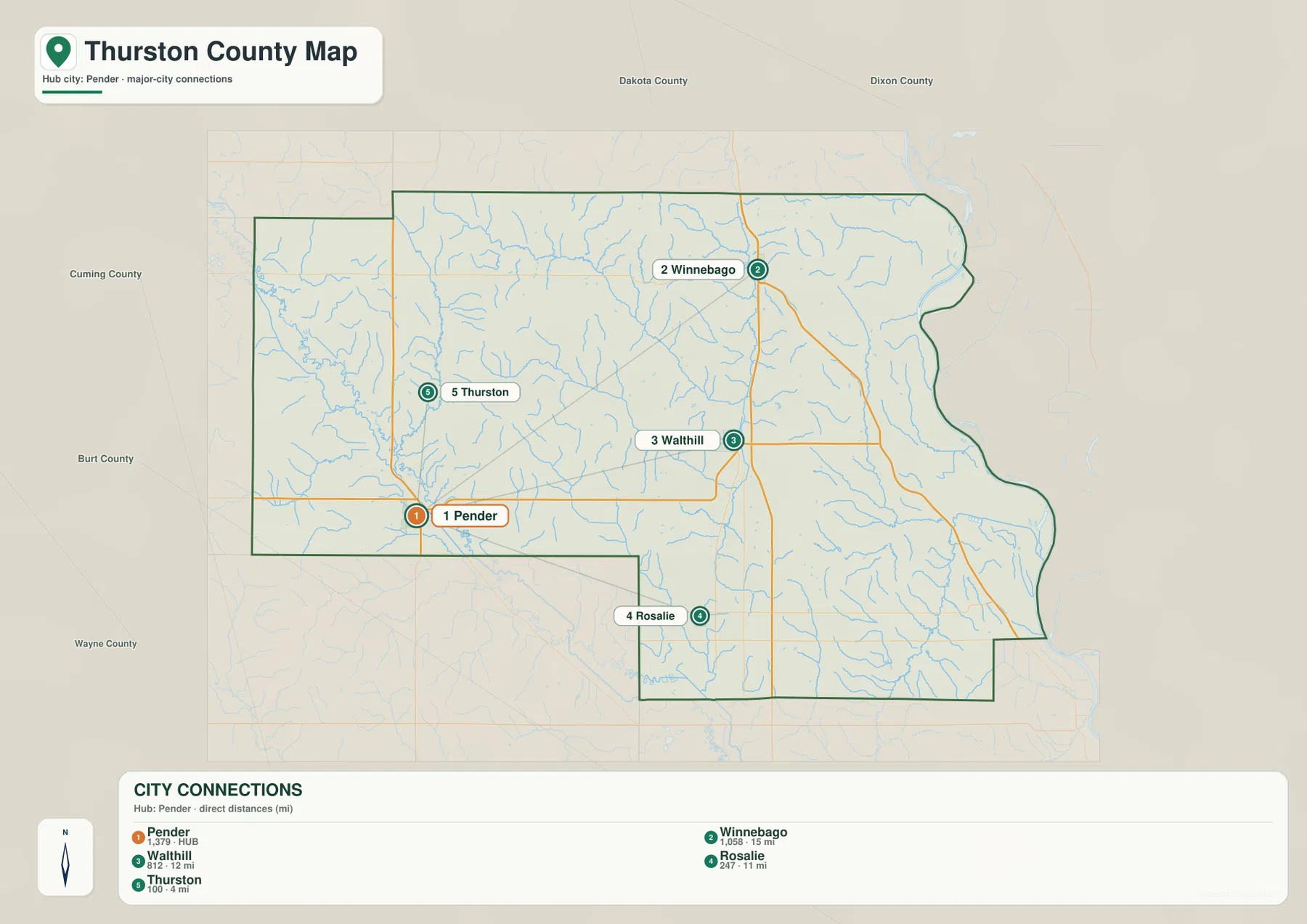
The graphic shows roughly 4 miles from Pender to Thurston, 11 miles to Rosalie, 12 miles to Walthill, and 15 miles to Winnebago. These are straight-line distances between mapped points rather than road mileage. Actual driving distances can be longer because roads follow section lines, creek valleys, and available crossings instead of a direct line.
Thedford-style hub maps can sometimes be mistaken for route diagrams, but this one is better treated as a compact spacing guide. Thurston is clearly the closest ranked community to Pender, while Winnebago is the farthest. Walthill and Rosalie fall between those extremes in different directions. Macy does not appear in the ranked panel, reinforcing that the city graphic is selective rather than a complete inventory of every named place in the county.
Missouri River lowlands and the Omaha-Blackbird creek network
The water map is anchored by the Missouri River along the eastern edge of Thurston County. The county boundary bends with the river, producing a broad low eastern margin that contrasts with the more dissected interior. Numerous streams drain eastward from the uplands toward the Missouri system.
North Omaha Creek and Omaha Creek cross the northern and central portions of the county. Middle Creek, Cow Creek, and South Omaha Creek add separate interior valleys, while North Blackbird Creek and Horsehead Creek drain the east-central area. Farther south, Blackbird Creek and South Blackbird Creek approach the Missouri River side. Around Pender, Old Channel, Logan Creek Dredge, and Bellmar Creek form another set of low corridors.
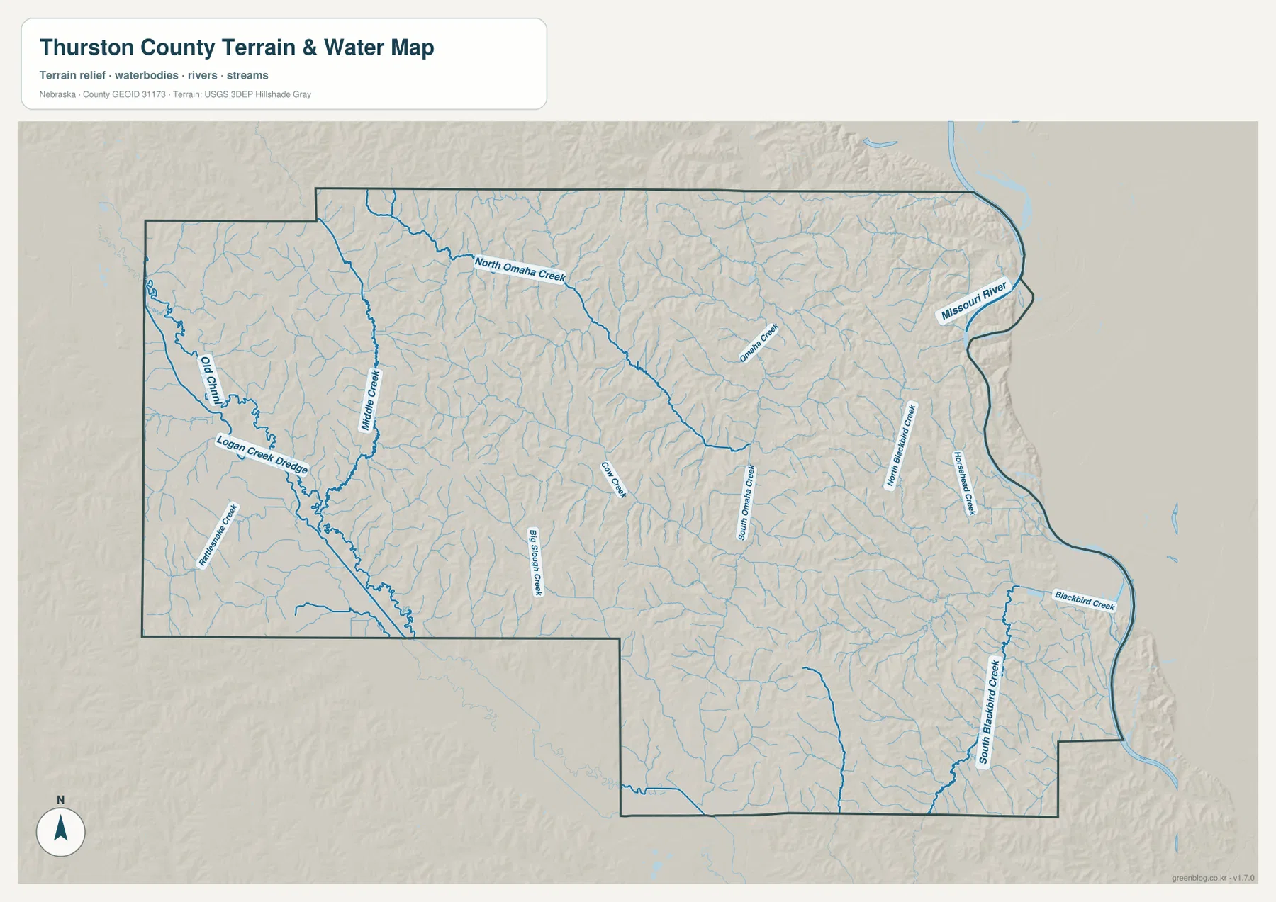
Walthill’s municipal history describes the community as occupying rolling ground within the Omaha Indian Reservation, and the terrain map helps explain that description. Creeks cut a series of valleys through the northeastern hills, so the area is not a flat extension of the Missouri River plain. Roads and communities sit among those creek valleys rather than on one continuous level surface.
Blue line thickness and color do not measure discharge, depth, or flood risk. The image is designed to show the location of rivers, creeks, channels, and drainage features at county scale. Floodplain decisions, stream access, property restrictions, and safety questions require current information from FEMA, USGS, or the appropriate local agencies.
Higher western hills above the Missouri River and creek valleys
The elevation map shows a clear difference between western Thurston County and the Missouri River side. The displayed surface ranges from about 317 to 473 meters, with a mean near 409 meters. Brown and orange dominate many western and west-central hills, while green expands across the eastern river lowlands and follows major creek valleys through the interior.
North Omaha Creek and Omaha Creek create long lower corridors through the north, and South Omaha Creek forms another green route farther south. Blackbird Creek tributaries cut into the eastern hills before reaching the Missouri lowlands. Between those channels, narrow ridges remain higher, giving the central and northeastern parts of the county a much more dissected appearance than the general road map suggests.
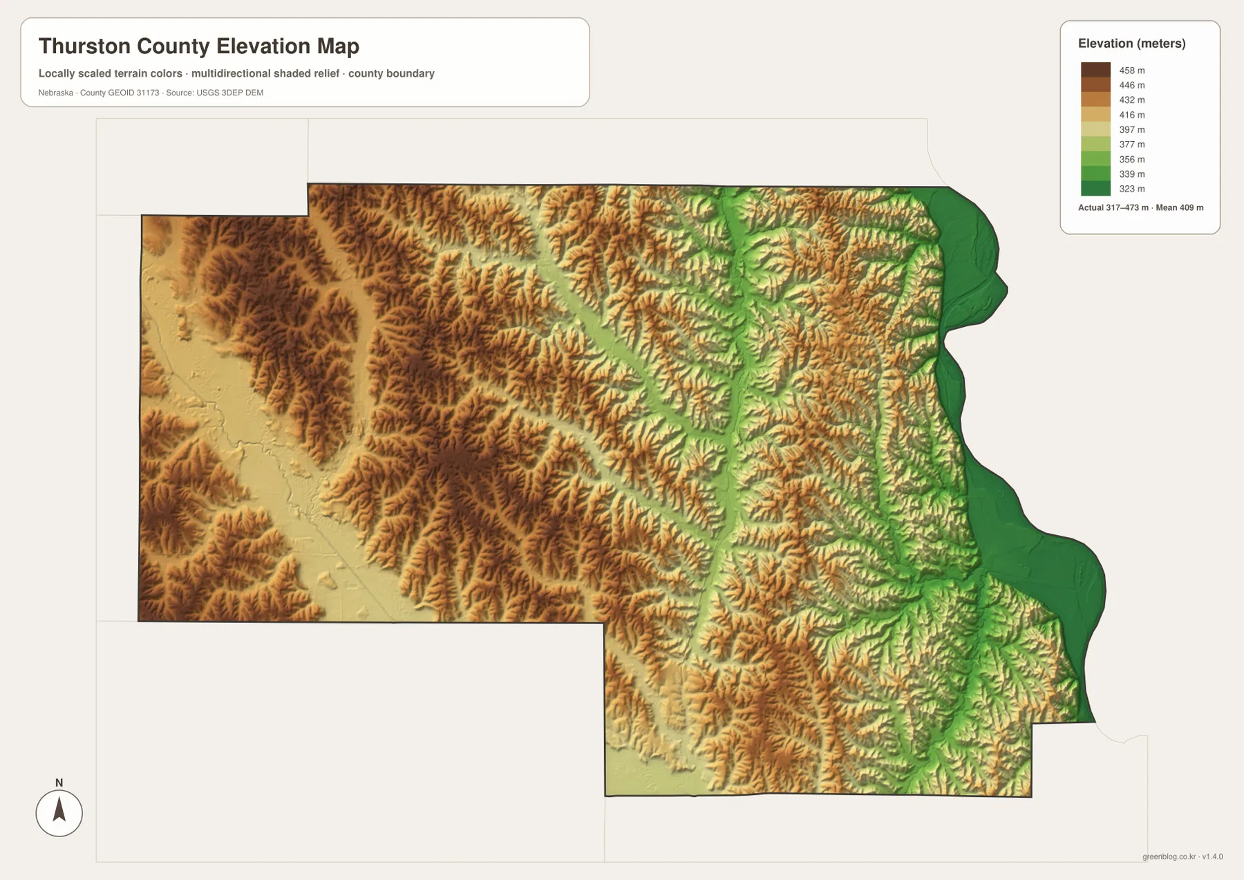
Pender lies near the transition between higher western terrain and several lower drainage corridors. Moving toward Walthill and Winnebago, repeated creek valleys and ridges become especially visible. Macy is much closer to the broad Missouri River lowland, which appears as one of the lowest and smoothest parts of the county on the shaded-relief image.
This elevation surface is intended for county-scale comparison, not parcel surveying or engineering. Exact site elevations, road grades, construction benchmarks, and design values require USGS source data, professional surveying, or another appropriate technical source. Here the image is most useful for comparing the western hills, the Omaha Creek valleys, and the low Missouri River margin.
Omaha and Winnebago reservation history across Thurston County
Thurston County’s official history emphasizes that the county has a distinctive shared tribal history. Before Nebraska became a state, the federal government established an Omaha Tribe reservation in the area. A northern portion was later purchased and designated for the Winnebago Tribe, helping shape the modern geography of Winnebago, Walthill, Macy, and surrounding rural areas.
The county was formally established under its present boundaries in 1889 and named for Nebraska U.S. Senator John M. Thurston. The county’s first village, Athens, had been established a few years earlier. Buildings were later moved about two miles northwest to the developing railroad location that became Pender, which became the county seat and remains the center of county government today.
Walthill adds another important historical layer. The village’s official history and National Park Service records connect it closely with Dr. Susan La Flesche Picotte, who became the first Native American woman to earn a medical degree in the United States and returned to serve the Omaha community. The Dr. Susan La Flesche Picotte Memorial Hospital in Walthill is recognized as a National Historic Landmark associated with her medical and social work.
These histories give the settlement map more meaning than a simple list of town names. Pender is the county government center, while Walthill, Winnebago, and Macy are important reference points within landscapes shaped by Omaha and Winnebago reservation history. Reading the county map alongside official local history helps connect road locations, community names, and the broader human geography of northeastern Nebraska.
A practical order for comparing towns, rivers, and relief
Begin with the general county map by locating Pender, Walthill, Winnebago, and Macy, then trace Nebraska 94 toward the eastern half of the county. The city-connection map provides a second view by showing straight-line spacing from Pender to four ranked communities. Because those mileages are not driving distances, they work best as a quick scale reference rather than a route-planning tool.
Next, use the water map to find Omaha Creek, Blackbird Creek, and the Missouri River. The elevation image then reveals how those waterways occupy green lower corridors between higher ridges. The contrast is especially strong between the western Pender side and the broad Missouri River lowland, with Walthill and Winnebago occupying more dissected terrain between them.
High-resolution JPG files are better suited to printing and close inspection when smaller creek names and route numbers matter. These maps remain regional references rather than legal or safety documents. County boundaries can be checked against Census TIGER/Line data, waterways against USGS National Hydrography, and elevation against the USGS 3D Elevation Program.
Frequently Asked Questions
Are the Pender-to-Walthill and Pender-to-Winnebago mileages driving distances?
No. The city-connections map shows straight-line distances: about 12 miles from Pender to Walthill and 15 miles from Pender to Winnebago, with Rosalie at about 11 miles and Thurston at about 4 miles. Actual road mileage can be longer.
Which side of Thurston County follows the Missouri River?
The Missouri River forms the winding eastern edge of the county. Omaha Creek and Blackbird Creek tributaries cross the interior toward that side, and the elevation map shows the river margin as one of the county’s lowest areas.
Can the elevation map be used for surveying or engineering?
No. It is designed to compare the western hills, creek valleys, and Missouri River lowlands at county scale. Exact site elevations, road grades, and engineering benchmarks require appropriate USGS source data or professional surveying.
Map File Information
Download the four high-resolution JPG maps shown on this page for Thurston County in one ZIP archive.
- Included Files: Use only the versions confirmed in the article and supplied images
- File Type: Use the confirmed download contents
- Intended Use: Printing, education, presentations, and map-based projects
Related Maps
Sources and references
County formation, Pender county-seat history, and Omaha-Winnebago reservation background come from the official Thurston County website. Walthill and Susan La Flesche Picotte background comes from the village history and National Park Service, while the federal sources below provide authoritative references for boundaries, hydrography, and elevation.
- Thurston County – About Our County
- Village of Walthill – History
- National Park Service – Susan La Flesche Picotte House
- U.S. Census Bureau – TIGER/Line Shapefiles
- USGS – National Hydrography
- USGS – 3D Elevation Program
Green Map creates custom-edited map images using open geographic data sources such as geoBoundaries, Natural Earth, OpenStreetMap, and government open data. These maps are edited visual materials, not raw data files, and are provided for education, documents, presentations, and graphic reference.