Sarpy County occupies a compact part of eastern Nebraska immediately south of Omaha, with Bellevue, Papillion, La Vista, Gretna, and Springfield forming its main urban centers. This Sarpy County Map page brings together county roads and boundaries, the distribution of those five cities, the Platte, Missouri, and Elkhorn rivers, smaller Papillion Creek tributaries, and an elevation view that contrasts the higher western hills with lower river land along the south and east. The WebP images are designed for quick viewing, and the same four maps are available below as high-resolution JPG files in one ZIP archive. High-resolution map files are available for download in the section below.
Bellevue and Papillion are the easiest places to use as anchors. Bellevue sits on the eastern side near the Missouri River, Papillion lies farther west near the middle of the county, and La Vista is close to Papillion on the north. Gretna and Springfield are separated farther west and southwest. The Platte River bends along the southern edge, the Missouri forms the eastern edge, and the Elkhorn River reaches the western side, giving Sarpy County a distinctive setting between several major waterways.
Table of Contents
Bellevue, Papillion, La Vista, and the road network across a compact county
The general map immediately emphasizes Bellevue and Papillion. Bellevue occupies the eastern side near the Missouri River, while Papillion lies closer to the county center. La Vista is just north of Papillion, creating a closely spaced group of cities in the northeast. Ralston appears outside the county to the north, providing a useful reminder that Sarpy County is directly connected to the wider Omaha metropolitan area.
Gretna lies farther west, with Springfield to its southeast. U.S. 6 enters from the west near Gretna, Nebraska 31 runs north and south through the western side, and Nebraska 50 passes near Springfield. Nebraska 370 crosses the central urban area between Papillion and Bellevue, while U.S. 34 reaches the southeast near the Missouri River. Together these routes show how a dense northeastern urban area connects with the more open western and southern portions of the county.
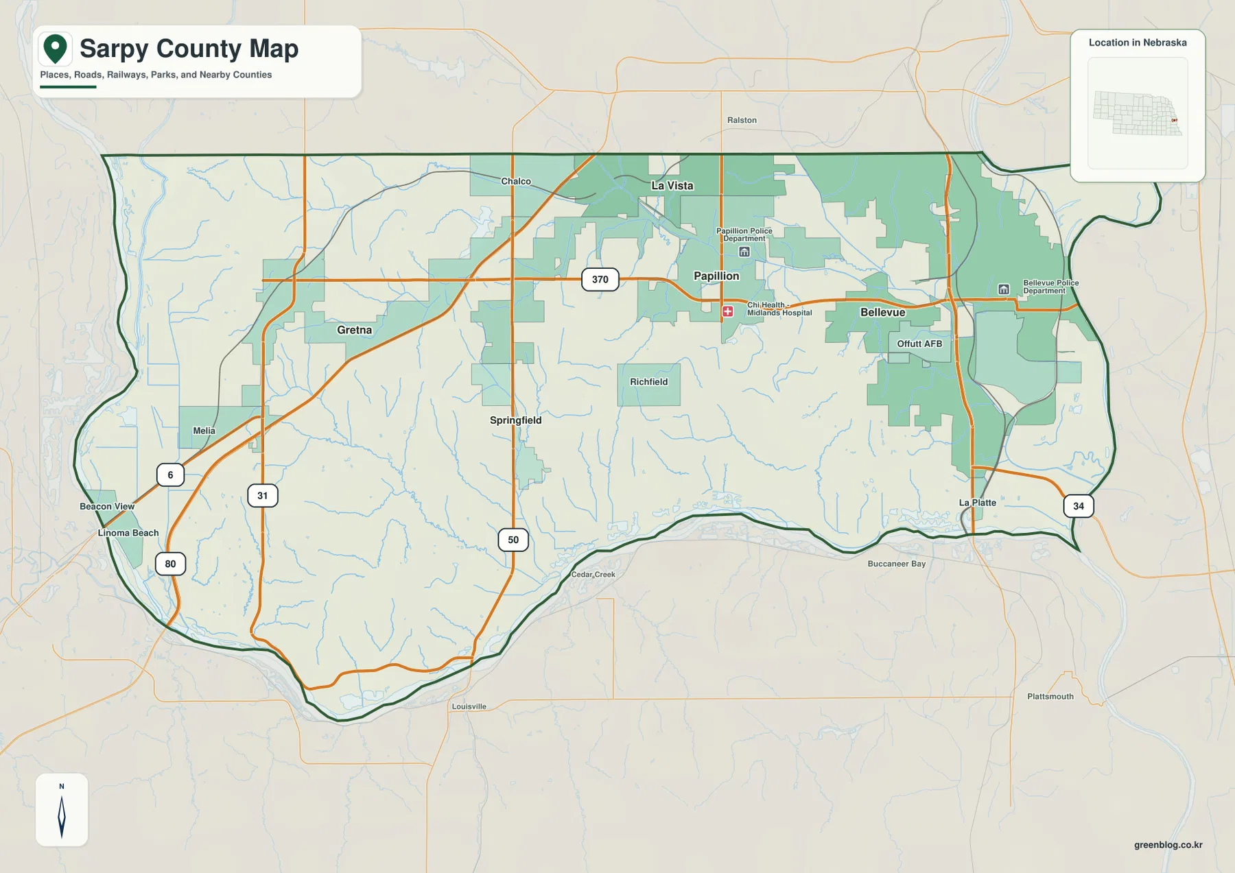
Papillion is the county seat. The official Sarpy County website identifies Bellevue, Gretna, La Vista, Papillion, and Springfield as the county’s cities and also notes the presence of Offutt Air Force Base. Offutt is labeled south of Bellevue on the supplied map. Establishing these major places first makes the water and elevation maps easier to use because the reader can connect terrain features to recognizable urban locations.
This is a regional reference rather than a live navigation map. Construction, temporary closures, and traffic conditions can change, so current routing should come from up-to-date transportation or navigation services. The map is more useful for questions such as how Bellevue relates to Gretna, where Papillion sits relative to Springfield, or which highways cross the county from one major community toward another.
Five major cities and a clear northeastern concentration
The city-distribution graphic strips away most road detail and highlights Bellevue, Papillion, La Vista, Gretna, and Springfield. Bellevue ranks first on the map, Papillion second, and La Vista third. Those three places occupy the eastern and northeastern part of the county, while Gretna stands farther west and Springfield farther southwest. The spacing makes the county’s population pattern much easier to understand than a simple list of city names would.
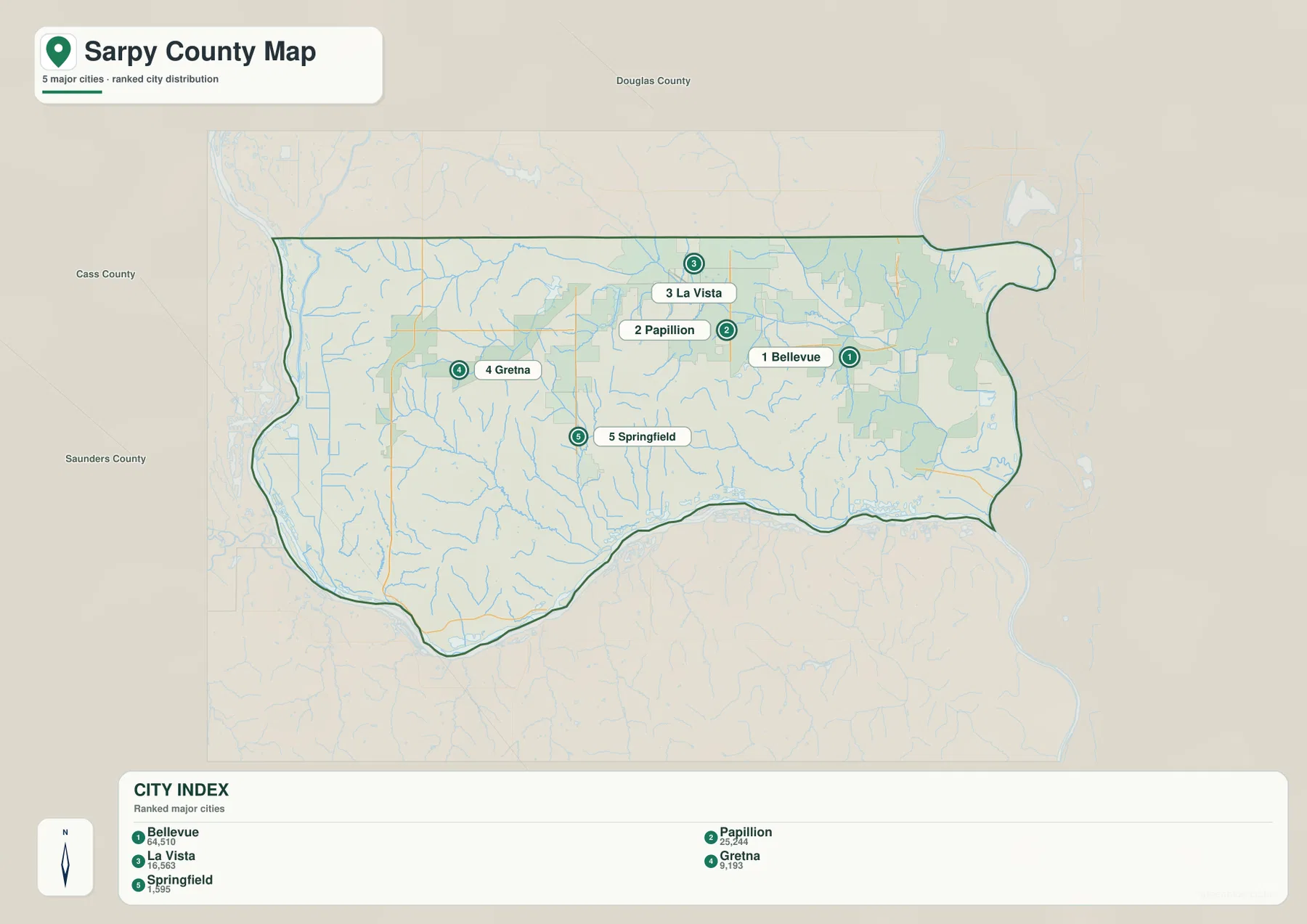
The ranking panel provides relative population context, but anyone who needs current population totals should use the latest Census or city estimates rather than relying on a static map. For geographic reading, the more useful point is that the largest communities are not evenly distributed. Bellevue, Papillion, and La Vista occupy a compact northeastern zone, while Gretna and Springfield provide reference points across the broader western and southern landscape.
Sarpy County’s official profile describes it as Nebraska’s smallest county by area, at about 241 square miles, while also reporting a 2020 Census population of 190,604. That combination helps explain why the city map looks so concentrated compared with many Nebraska county maps. A relatively small area contains several substantial urban communities, especially along the northern and eastern sides.
Platte, Missouri, and Elkhorn rivers around the county’s edges
The terrain-and-water map makes Sarpy County’s river setting unmistakable. The Platte River follows the southern boundary from west to east, the Missouri River forms the eastern side, and the Elkhorn River reaches the western edge. Seen together, the three rivers explain many of the county boundary’s curves and create a strong contrast between the interior hills and the broad lowlands near the largest waterways.
Inside the county, South Papillion Creek and West Papillion Creek cross the northern and central portions, while Buffalo Creek and Springfield Creek drain toward the Platte River. Papillion Creek appears near the southeast and continues toward the Missouri River. These smaller streams cut a dense network of valleys through the interior, adding much more relief than a road map alone suggests.
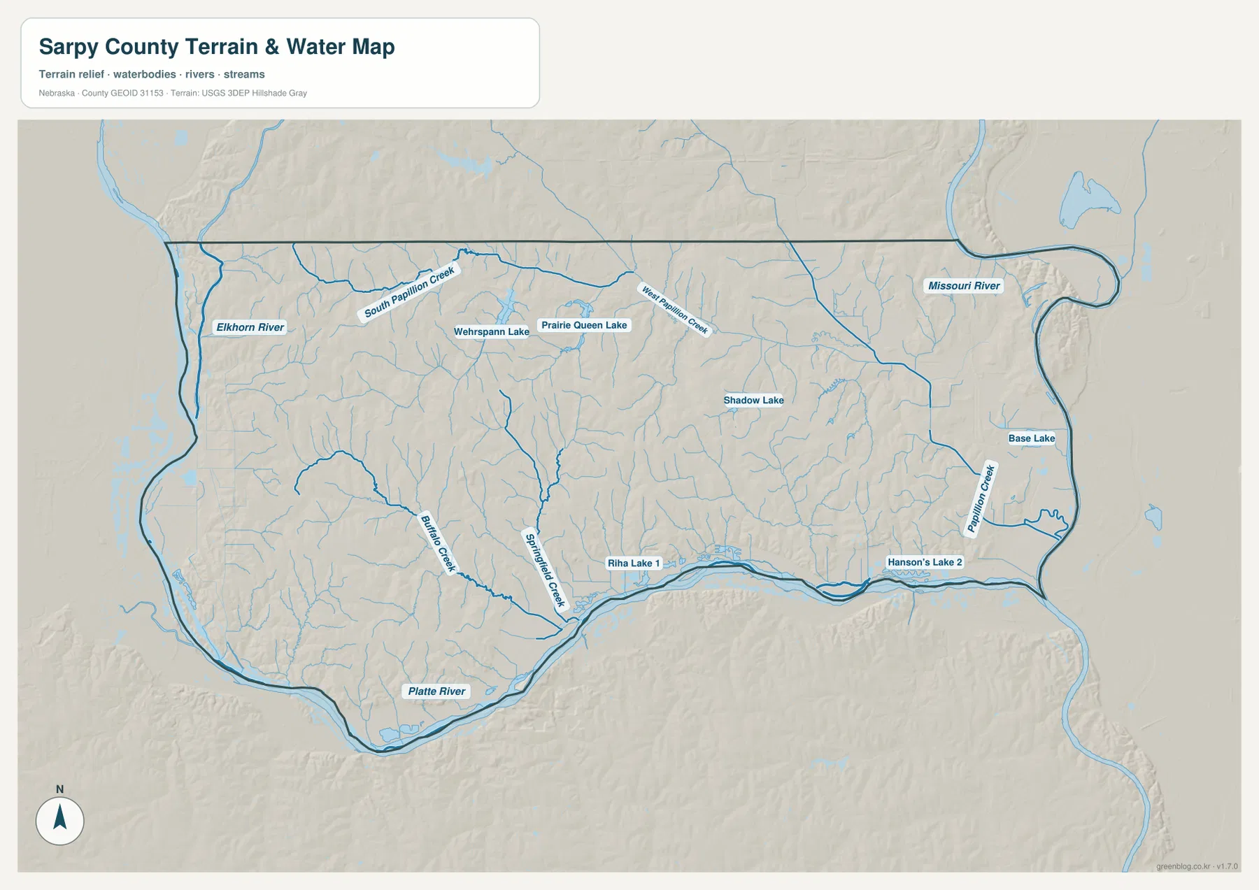
The map also labels Wehrspann Lake, Prairie Queen Lake, Shadow Lake, Base Lake, Riha Lake 1, and Hanson’s Lake 2. These labels are useful for orientation, but the image does not provide current water level, access, water-quality, or recreation status. Visitors planning fishing, boating, or park use should check the appropriate managing agency for current rules and conditions.
Blue line width and color should not be interpreted as discharge, water depth, or flood risk. This map is a county-scale reference for location. Floodplain decisions, property regulation, levee status, and safety questions require current official sources from FEMA, the local natural-resources district, USGS, or other responsible agencies. For general geography, the map works well because it places major rivers, tributaries, and lakes in one consistent view.
Western hills above the Platte and Missouri river lowlands
The elevation map reveals a strong contrast within a relatively small county. Brown and orange tones dominate the west and west-central hills, while green follows the broad lowlands along the Platte River in the south and the Missouri River in the east. The displayed surface ranges from roughly 289 to 398 meters, with a mean near 338 meters. The key geographic point is not the exact number at every location but the clear difference between higher interior hills and lower river margins.
The northeastern urban area is lower than the highest western ridges but is still cut by numerous creek valleys. Papillion Creek tributaries create green corridors through rolling terrain, while the Platte River valley forms a much broader low strip across the south. West and southwest of Gretna, stronger brown shading marks some of the county’s highest ground, creating a noticeable contrast with Bellevue and the river-edge lowlands.
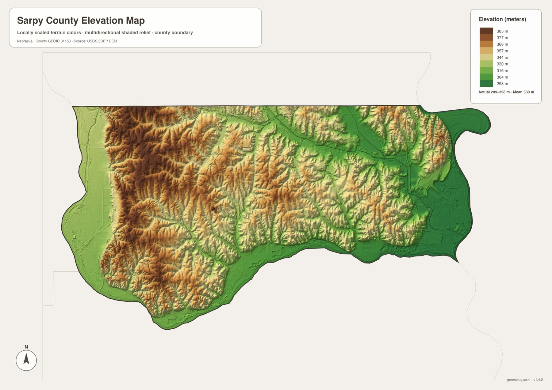
Comparing the water and elevation images makes the relationship easy to see. South Papillion Creek and West Papillion Creek occupy lower corridors through the interior, while Buffalo Creek and Springfield Creek descend toward the Platte. The river valleys are not isolated features; they are the lowest parts of a rolling landscape that rises noticeably toward western Sarpy County.
This elevation surface is intended for county-scale comparison, not parcel surveying or engineering. It should not be used to establish exact site elevations, road grades, building benchmarks, or design values. Those purposes require USGS source elevation data, professional surveying, or another suitable authoritative dataset.
Papillion as county seat and Bellevue’s connection to Sarpy County history
Sarpy County is named for Peter A. Sarpy, an early fur trader associated with the Bellevue area in the 1840s, according to the county’s official profile. Bellevue remains the largest city highlighted on the supplied city map and sits close to the Missouri River. The historical connection is useful because it ties the county name to the same eastern river corridor that remains prominent on modern maps.
Papillion is the county seat and occupies a central position between Bellevue and the western communities. La Vista lies immediately to the north, while Springfield provides a smaller reference point closer to the Platte River side of the county. This arrangement makes Papillion a convenient geographic anchor even when the reader is more interested in terrain and rivers than in county government.
Offutt Air Force Base lies south of Bellevue and is also identified by Sarpy County as a major presence in the county. The general map shows its location relative to Bellevue, U.S. 34, and the Missouri River side of the county, but this page is not a guide to military facilities or access. Its role here is simply to help orient the reader within the broader county landscape.
The official county profile places Sarpy County directly south of Omaha and lists Bellevue, Gretna, La Vista, Papillion, and Springfield as its main cities. That combination of closely spaced urban communities, major river boundaries, and rolling western terrain gives Sarpy a visual character that differs from many larger rural Nebraska counties. The four maps are particularly useful here because settlement and physical geography are both prominent.
Choosing a map for printing, teaching, or local comparison
Use the general county map when you need roads, major communities, the boundary, and nearby places in one view. Bellevue and Papillion are the easiest starting points, followed by La Vista, Gretna, and Springfield. The city-distribution graphic is cleaner when the goal is simply to compare the five major cities and see how strongly they cluster in the northeast.
The water map is best for tracing the Platte, Missouri, and Elkhorn rivers and the Papillion Creek system. The elevation image then shows why river corridors appear as broad lowlands and why the western part of the county contains stronger relief. In a classroom, students can locate the five cities first, identify the three major rivers next, and then compare those same areas on the elevation image.
High-resolution JPG files are better suited to printing and close inspection when small stream names and route numbers matter. These maps remain regional references rather than legal or safety documents. County boundaries can be checked against Census TIGER/Line data, waterways against USGS National Hydrography, and elevation against the USGS 3D Elevation Program.
Frequently Asked Questions
Which map is easiest for comparing Bellevue, Papillion, and La Vista?
The city-distribution map is the simplest choice because it highlights the five major cities without most road detail. Bellevue is in the east, Papillion lies farther west near the center, and La Vista is just north of Papillion. Use the general map when highway and local road context also matters.
Which sides of Sarpy County are defined by the Platte and Missouri rivers?
The Platte River follows the southern edge of the county, while the Missouri River forms the eastern side. The Elkhorn River reaches the western boundary, and the interior contains South Papillion Creek, West Papillion Creek, and several other tributaries.
Can the elevation map be used for surveying or construction design?
No. It is designed to compare the higher western hills with the lower river valleys at county scale. Exact site elevations, road grades, and engineering benchmarks require appropriate USGS source data or professional surveying.
Map File Information
Download the four high-resolution JPG maps shown on this page for Sarpy County in one ZIP archive.
- Included Files: Use only the versions confirmed in the article and supplied images
- File Type: Use the confirmed download contents
- Intended Use: Printing, education, presentations, and map-based projects
Related Maps
Sources and references
County-seat, city, area, population, naming, and Offutt Air Force Base background comes from the official Sarpy County website. The federal sources below provide authoritative references for boundaries, hydrography, and elevation data.
- Sarpy County – About Sarpy County
- U.S. Census Bureau – TIGER/Line Shapefiles
- USGS – National Hydrography
- USGS – 3D Elevation Program
Green Map creates custom-edited map images using open geographic data sources such as geoBoundaries, Natural Earth, OpenStreetMap, and government open data. These maps are edited visual materials, not raw data files, and are provided for education, documents, presentations, and graphic reference.