Morgan County occupies a deeply dissected part of central Missouri between the Lamine River drainage in the north and the Lake of the Ozarks shoreline in the south. Versailles is the clearest reference point near the center of the county, with Stover to the west, Barnett to the east, Syracuse to the north, and Gravois Mills and Laurie farther south. Route 52 crosses the middle of the county, Route 5 runs from Versailles toward the lake, and Route 135 provides another north-south reference around Stover. High-resolution map files are available for download in the section below.
This page separates those features into a general county map, a city distribution map, a terrain-and-water map, and an elevation map. The four high-resolution JPG originals can also be downloaded together in one ZIP for closer inspection, A3 printing, classroom use, reports, or other large-format reference work.
Table of Contents
Versailles ties together the county’s main road references
Versailles is the easiest place to begin reading the general map. Route 52 passes through the city from west to east, connecting the Stover side of the county with Barnett and the eastern boundary. Route 5 leaves Versailles toward the south and continues through the Gravois Mills and Laurie side of the county, making it the most obvious road reference for reaching the Lake of the Ozarks area.
Stover forms a second important road reference in the west. Route 135 runs through the area and connects local roads north and south of town. In the upper county, U.S. 50 crosses near the northern edge and provides a separate east-west corridor around Syracuse. The road pattern therefore changes noticeably from the broad northern uplands to the more winding lake country in the south.
Near Gravois Mills and Laurie, the roads bend more often because they cross narrow ridges and follow the spaces between reservoir arms. The contrast with the straighter sections farther north is easy to see even without reading every local road name. That change in road shape is one of the clearest visual clues that the southern part of Morgan County has a much more intricate shoreline and valley pattern.
Six highlighted places stretch from Syracuse to Laurie
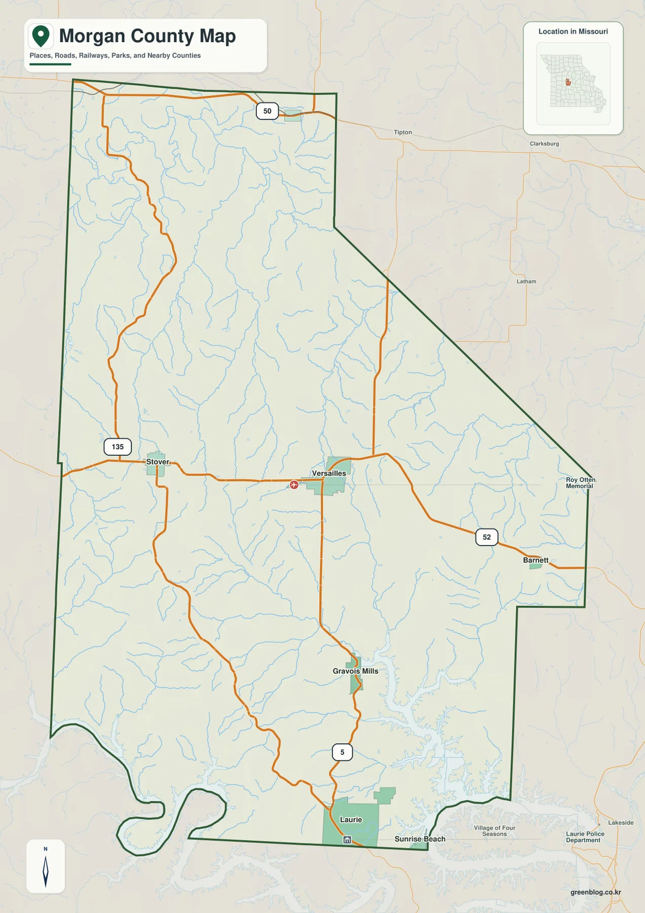
The city map highlights Versailles, Stover, Laurie, Syracuse, Barnett, and Gravois Mills. Versailles is ranked first in the map’s city index, Stover second, and Laurie third, followed by Syracuse, Barnett, and Gravois Mills. The ranking is a quick guide to the featured places, but the geographic spread is more useful when you are learning the county.
Versailles occupies the central part of the map, Stover lies west of it, and Barnett sits farther east. Syracuse is separated from the other highlighted towns near the northern edge, while Laurie and Gravois Mills form the southern pair near the Lake of the Ozarks. Once those six positions are familiar, it becomes much easier to understand where the creek valleys and higher ridges shown on the terrain maps are located.
The simplified city view is especially useful because Morgan County has many small roads and branching valleys. By removing most of that detail, the map makes the north-south contrast obvious: Syracuse is associated with the northern U.S. 50 corridor, Versailles and Stover define the middle, and Laurie and Gravois Mills belong to the lake-oriented south. For actual navigation, current road information should still be used.
Lamine River tributaries in the north and reservoir coves in the south
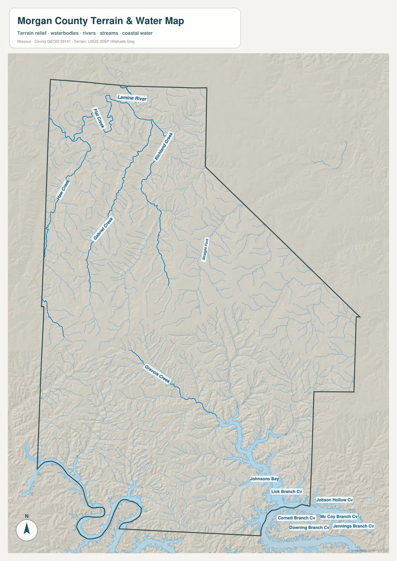
The terrain-and-water map shows a strong contrast between the northern and southern halves of the county. In the north, the Lamine River is the main named waterway, joined by streams such as Flat Creek and Richland Creek. Hawk Creek and Gabriel Creek occupy long valleys in the northwest, while smaller tributaries cut the uplands into a repeating pattern of ridges and narrow low corridors.
Farther south, Gravois Creek becomes the clearest named drainage. It winds southeast through the lower county before reaching the complex shoreline of the Lake of the Ozarks. Around the reservoir, Johnsons Bay and several named coves extend into former stream valleys, producing a much more deeply indented water edge than the Lamine River corridor in the north.
That shoreline pattern is one of the defining geographic features of southern Morgan County. Water reaches far into the surrounding hills, and many narrow branches separate ridges that would otherwise appear continuous. The map is intended for locating rivers, creeks, bays, and coves; it is not a flood-risk map, depth chart, navigation product, parcel map, or legal water-boundary survey.
Relief ranges from about 200 to 361 meters
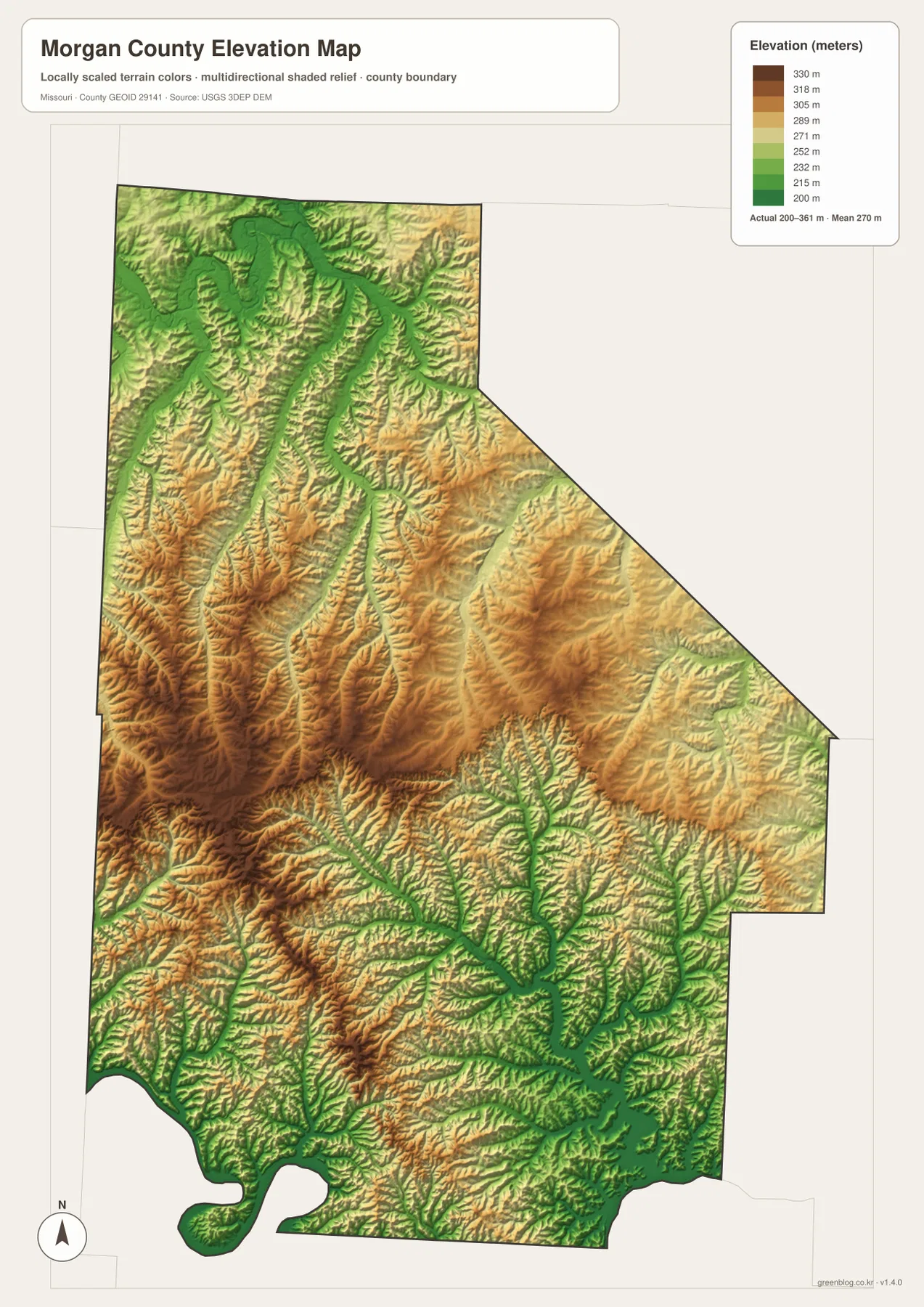
The elevation map reports an actual range of roughly 200 to 361 meters and a mean near 270 meters. The lowest greens follow the Lamine River and its tributary valleys across the north. Similar low corridors branch through the southern lake country, where the reservoir occupies former valleys and creates long green fingers between higher ridges.
The broadest higher ground appears across the central-western and southwestern interior. Brown and dark tan ridges rise south of Stover and west of Versailles, with many smaller creek valleys cutting into them. Around Syracuse, the relief is still noticeable, but the pattern is more strongly organized around valleys descending toward the Lamine River than around a single broad upland block.
The lake side of the county is especially intricate. High ridges repeatedly descend into narrow low valleys that are now partly occupied by the Lake of the Ozarks, so the elevation colors create a branching pattern around the shoreline. This county-scale elevation surface is useful for comparing broad relief but is not appropriate for engineering, drainage design, construction, parcel-level elevation decisions, or any task requiring survey-grade measurements.
Which map should you use first?
Use the general county map first when roads and settlement locations matter most. Versailles provides the clearest central anchor, Route 52 explains the east-west relationship between Stover and Barnett, Route 5 leads toward Gravois Mills and Laurie, and U.S. 50 helps locate the northern Syracuse area. The city map is faster when you only need the relative positions of the six highlighted places.
For rivers, creeks, and lake shoreline, the terrain-and-water map contains much more detail. After locating the Lamine River, Richland Creek, Gravois Creek, and the reservoir coves, switch to the elevation map to see how those water features occupy lower corridors between ridges. Comparing the two maps side by side makes the contrast between the northern river valleys and southern lake country especially clear.
The downloadable JPG originals provide more pixels than the WebP previews on the page and are better suited to enlargement, A3 printing, classroom handouts, reports, and personal reference. They remain general-purpose maps, however. Legal boundaries, land ownership, live traffic conditions, flood status, water levels, and precise site elevations should always be checked against the appropriate current official source.
Frequently Asked Questions
Which road connects Versailles with the Lake of the Ozarks side of Morgan County?
Route 5 is the clearest north-south road reference on the map. It runs south from Versailles toward Gravois Mills and Laurie, where the road network becomes more winding around reservoir arms and steep creek valleys.
How much elevation change is shown across Morgan County?
The elevation map shows an actual range of about 200 to 361 meters with a mean near 270 meters. The Lamine River and lake valleys are lowest, while the central-western and southwestern ridges contain some of the highest terrain.
Does the water map show the small coves around the Lake of the Ozarks?
Yes. The southern part of the map labels Johnsons Bay and several individual coves, along with Gravois Creek and smaller tributaries. The downloadable high-resolution JPG makes those shoreline details easier to inspect than the smaller page preview.
Map File Information
The download ZIP contains high-resolution JPG versions of the Morgan County general map, city map, terrain-and-water map, and elevation map.
- File Type: JPG
Related Maps
Sources and References
Boundary and road reference data are supported by U.S. Census Bureau TIGER/Line, water features by USGS National Hydrography, and elevation data by the USGS 3D Elevation Program. These maps are general geographic references and are not substitutes for legal surveys or current operational data.
Green Map creates custom-edited map images using open geographic data sources such as geoBoundaries, Natural Earth, OpenStreetMap, and government open data. These maps are edited visual materials, not raw data files, and are provided for education, documents, presentations, and graphic reference.